

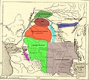
Maringa-Lopori-Wamba Landscape
Encyclopedia
The Maringa-Lopori-Wamba Landscape (MLW) is an ecologically sensitive landscape
in the Democratic Republic of the Congo
within the Maringa
/ Lopori
basin.
Since 1973 a Japanese team has been researching the bonobo
population near the village of Wamba
in 1973, and the Luo Scientific Reserve was established in 1990.
However, research was discontinued after political disorders started in 1991 followed by civil war in 1997, resuming only in the mid-2000s.
The human population as of 2007 was estimated to be 586,732 inhabitants with a density of 8 inhabitants/km2.
There were 2-4 inhabitants/km2 in the proposed or existing protected areas and 31.8 inhabitants/km2 in the proposed Sylvo-Agro-Pastoral zone.
 The local populace in the MLW were yam
and cassava
farmers who engaged in trade with river fishermen and pygmy
hunters..
In 1885 a force of the Manyema
people, followers of Tippu Tip
, the Swahili
-Zanzibar
i slave trader, arrived at the head of the Lopori River from Stanley Falls.
They took hostages from nearby villages to ransom in return for ivory
. By 1892 they had enrolled local people into their army and controlled the entire eastern half of the basin.
The Belgian administrators of the Congo Free State
was concerned by this development and in 1889 enacted the Monopoly Act which declared that all products in the area were to be under their jurisdiction alone.
The Free State also began a campaign to drive the slavers, traders and the Manyema from the region, the first stage of which was the establishment of a supply post at Basankusu
in May 1890.
The entire basin was under Free State control by 1898.
The Free State started to levy taxes payable in ivory, but soon switched to wild rubber.
By September 1892 the Free State was using its military forces to attack and occupy villages in the Lulonga
and Maringa river valleys in order to expand its tax base.
The concession to farm rubber was granted to the Abir Congo Company
, which established its headquarters at Basankusu in 1893.
Its position at the confluence of the Maringa and Lopori allowed ABIR to expand along these rivers and their tributaries, establishing new posts along the way.
The company established posts throughout the region, staffed by agents who were mainly paid on commission and used brutal methods to force the villagers to pay their rubber taxes.
The effort of rubber collection did not leave enough time for forming, and the villagers began to suffer from malnutrition and starvation. Fatal diseases such as Smallpox and Sleeping Sickness also spread in the region. To save time, harvesters resorted to cutting down the rubber plants to obtain their sap.
Reports of abuses led the Free State to conduct investigations into Abir's conduct, and in 1905 to take back the concession.
Soon after, with no remaining plants, the rubber tax was abolished.
The inhabitants are among the poorest in Africa, depending on natural resources to meet their basic needs.
Most of the people live by slash-and-burn agriculture, and rely on bushmeat such as porcupine, sitatunga, and forest hog for protein.
Cash crops include maize, cassave and groundnuts.
The growing population is placing more stress on the environment, and there is risk of a revival of logging that could harm the ability of the land to sustain the people and could jeopardize both biodiversity.
Local and international institutions headed by the African Wildlife Foundation
(AWF) have recently started developing a sustainable land use plan for the MLW. The plan aims to ensure that the economic and cultural needs of the inhabitants are met while conserving the environment.
The approach combines AWF's Heartland Conservation Process and the Central African Regional Program for the Environment (CARPE) Program Monitoring Plan.
A variety of tools are used including surveys, interviews with local people and satellite image interpretation.
|title=Maringa-Lopori-Wamba Landscape
|first1=Jef |last1=Dupain |first2=Janet |last2=Nackoney |first3=Jean-Paul |last3=Kibambe |first4=Didier |last4=Bokelo |first5=David |last5=Williams
|publisher=L'Observatoire des Forêts d'Afrique Centrale
|year=2008
|accessdate=2011-1014}}
Landscape ecology
Landscape ecology is the science of studying and improving relationships between urban development and ecological processes in the environment and particular ecosystems...
in the Democratic Republic of the Congo
Democratic Republic of the Congo
The Democratic Republic of the Congo is a state located in Central Africa. It is the second largest country in Africa by area and the eleventh largest in the world...
within the Maringa
Maringa River
The Maringa river is a river in the Democratic Republic of the Congo. The Maringa, and the Lopori River to the north, join near Basankusu to form the Lulonga River, a tributary of the Congo River....
/ Lopori
Lopori River
The Lopori river is a river in the Democratic Republic of the Congo. The Lopori, and the Maringa River to the south, join near Basankusu to form the Lulonga River, a tributary of the Congo River....
basin.
Since 1973 a Japanese team has been researching the bonobo
Bonobo
The bonobo , Pan paniscus, previously called the pygmy chimpanzee and less often, the dwarf or gracile chimpanzee, is a great ape and one of the two species making up the genus Pan. The other species in genus Pan is Pan troglodytes, or the common chimpanzee...
population near the village of Wamba
Wamba, Luo Reserve
Wamba is a village in the Luo Scientific Reserve, Tshuapa District of the Democratic Republic of the Congo.It is inhabited by Bongando people.The reserve is home to bonobos, threatened due to hunting....
in 1973, and the Luo Scientific Reserve was established in 1990.
However, research was discontinued after political disorders started in 1991 followed by civil war in 1997, resuming only in the mid-2000s.
Location
The Maringa-Lopori-Wamba (MLW) forest Landscape covers 74000 square kilometres (28,571.6 sq mi) in north-central Democratic Republic of the Congo.The human population as of 2007 was estimated to be 586,732 inhabitants with a density of 8 inhabitants/km2.
There were 2-4 inhabitants/km2 in the proposed or existing protected areas and 31.8 inhabitants/km2 in the proposed Sylvo-Agro-Pastoral zone.
History
Yam (vegetable)
Yam is the common name for some species in the genus Dioscorea . These are perennial herbaceous vines cultivated for the consumption of their starchy tubers in Africa, Asia, Latin America and Oceania...
and cassava
Cassava
Cassava , also called yuca or manioc, a woody shrub of the Euphorbiaceae native to South America, is extensively cultivated as an annual crop in tropical and subtropical regions for its edible starchy tuberous root, a major source of carbohydrates...
farmers who engaged in trade with river fishermen and pygmy
Pygmy
Pygmy is a term used for various ethnic groups worldwide whose average height is unusually short; anthropologists define pygmy as any group whose adult men grow to less than 150 cm in average height. A member of a slightly taller group is termed "pygmoid." The best known pygmies are the Aka,...
hunters..
In 1885 a force of the Manyema
Manyema
Manyema , a powerful and in the past warlike Bantu-Negroid people in the southeast of the Congo basin and in the Kigoma region of Western Tanzania.In Tanzania they include various sub tribes , wabwari, wamasanze, wabembe e.t...
people, followers of Tippu Tip
Tippu Tip
Tippu Tip or Tib , real name Hamad bin Muḥammad bin Jumah bin Rajab bin Muḥammad bin Sa‘īd al-Murghabī, , was a Swahili-Zanzibari trader. He was famously known as Tippu Tib after an eye disease which made him blind...
, the Swahili
Swahili people
The Swahili people are a Bantu ethnic group and culture found in East Africa, mainly in the coastal regions and the islands of Kenya, Tanzania and north Mozambique. According to JoshuaProject, the Swahili number in at around 1,328,000. The name Swahili is derived from the Arabic word Sawahil,...
-Zanzibar
Zanzibar
Zanzibar ,Persian: زنگبار, from suffix bār: "coast" and Zangi: "bruin" ; is a semi-autonomous part of Tanzania, in East Africa. It comprises the Zanzibar Archipelago in the Indian Ocean, off the coast of the mainland, and consists of numerous small islands and two large ones: Unguja , and Pemba...
i slave trader, arrived at the head of the Lopori River from Stanley Falls.
They took hostages from nearby villages to ransom in return for ivory
Ivory
Ivory is a term for dentine, which constitutes the bulk of the teeth and tusks of animals, when used as a material for art or manufacturing. Ivory has been important since ancient times for making a range of items, from ivory carvings to false teeth, fans, dominoes, joint tubes, piano keys and...
. By 1892 they had enrolled local people into their army and controlled the entire eastern half of the basin.
The Belgian administrators of the Congo Free State
Congo Free State
The Congo Free State was a large area in Central Africa which was privately controlled by Leopold II, King of the Belgians. Its origins lay in Leopold's attracting scientific, and humanitarian backing for a non-governmental organization, the Association internationale africaine...
was concerned by this development and in 1889 enacted the Monopoly Act which declared that all products in the area were to be under their jurisdiction alone.
The Free State also began a campaign to drive the slavers, traders and the Manyema from the region, the first stage of which was the establishment of a supply post at Basankusu
Basankusu
Basankusu is a town in Équateur Province, Democratic Republic of the Congo. It is the main town and administrative centre of the Territory of Basankusu. It boasts an airport, covered and open markets, a hospital and two recently installed cellphone networks....
in May 1890.
The entire basin was under Free State control by 1898.
The Free State started to levy taxes payable in ivory, but soon switched to wild rubber.
By September 1892 the Free State was using its military forces to attack and occupy villages in the Lulonga
Lulonga River
The Lulonga is a river in the Equateur province of Democratic Republic of the Congo. It is about 200 km long from its beginning at the town of Basankusu. There the Lopori and the Maringa join to form the Lulonga. The Lulonga river flows into the Congo River at the town Lulonga....
and Maringa river valleys in order to expand its tax base.
The concession to farm rubber was granted to the Abir Congo Company
Abir Congo Company
The Abir Congo Company was a company which harvested natural rubber in the Congo Free State, the private property of King Leopold II of Belgium. The company was founded with British and Belgian capital and was based in Belgium...
, which established its headquarters at Basankusu in 1893.
Its position at the confluence of the Maringa and Lopori allowed ABIR to expand along these rivers and their tributaries, establishing new posts along the way.
The company established posts throughout the region, staffed by agents who were mainly paid on commission and used brutal methods to force the villagers to pay their rubber taxes.
The effort of rubber collection did not leave enough time for forming, and the villagers began to suffer from malnutrition and starvation. Fatal diseases such as Smallpox and Sleeping Sickness also spread in the region. To save time, harvesters resorted to cutting down the rubber plants to obtain their sap.
Reports of abuses led the Free State to conduct investigations into Abir's conduct, and in 1905 to take back the concession.
Soon after, with no remaining plants, the rubber tax was abolished.
Threats
The MLW Landscape is in one of the least developed and most remote parts of the Congo Basin.The inhabitants are among the poorest in Africa, depending on natural resources to meet their basic needs.
Most of the people live by slash-and-burn agriculture, and rely on bushmeat such as porcupine, sitatunga, and forest hog for protein.
Cash crops include maize, cassave and groundnuts.
The growing population is placing more stress on the environment, and there is risk of a revival of logging that could harm the ability of the land to sustain the people and could jeopardize both biodiversity.
Local and international institutions headed by the African Wildlife Foundation
African Wildlife Foundation
The African Wildlife Foundation , founded in 1961 as the African Wildlife Leadership Foundation, is an international conservation organization that focuses on critically important landscapes in Africa....
(AWF) have recently started developing a sustainable land use plan for the MLW. The plan aims to ensure that the economic and cultural needs of the inhabitants are met while conserving the environment.
The approach combines AWF's Heartland Conservation Process and the Central African Regional Program for the Environment (CARPE) Program Monitoring Plan.
A variety of tools are used including surveys, interviews with local people and satellite image interpretation.
Sources
|url=http://www.observatoire-comifac.net/docs/edf2008/EN/SOF_23_Maringa.pdf|title=Maringa-Lopori-Wamba Landscape
|first1=Jef |last1=Dupain |first2=Janet |last2=Nackoney |first3=Jean-Paul |last3=Kibambe |first4=Didier |last4=Bokelo |first5=David |last5=Williams
|publisher=L'Observatoire des Forêts d'Afrique Centrale
|year=2008
|accessdate=2011-1014}}