Marañón River
Encyclopedia


Lima
Lima is the capital and the largest city of Peru. It is located in the valleys of the Chillón, Rímac and Lurín rivers, in the central part of the country, on a desert coast overlooking the Pacific Ocean. Together with the seaport of Callao, it forms a contiguous urban area known as the Lima...
, Peru
Peru
Peru , officially the Republic of Peru , is a country in western South America. It is bordered on the north by Ecuador and Colombia, on the east by Brazil, on the southeast by Bolivia, on the south by Chile, and on the west by the Pacific Ocean....
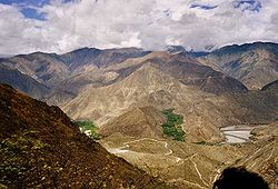
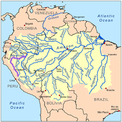
, flows through a deeply-eroded Andean
Andes
The Andes is the world's longest continental mountain range. It is a continual range of highlands along the western coast of South America. This range is about long, about to wide , and of an average height of about .Along its length, the Andes is split into several ranges, which are separated...
valley in a northwesterly direction, along the eastern base of the Cordillera
Cordillera
A cordillera is an extensive chain of mountains or mountain ranges, that runs along a coastline . It comes from the Spanish word cordilla, which is a diminutive of cuerda, or "cord"...
of the Andes, as far as 5 degrees 36' southern latitude; then it makes a great bend to the northeast, and cuts through the inland Andes, until at the Pongo de Manseriche
Pongo de Manseriche
The Pongo de Manseriche is a gorge in northwest Peru. The Marañón River runs through this gorge before it reaches the Amazon Basin.The Pongo de Manseriche is 3 miles long, located at 4° 27' 30" south latitude and 77° 34' 51" west longitude, just below the mouth of the Rio Santiago, and between it...
it flows through the plains. After its confluence with Río Ucayali, the Marañón is given the name of the Amazon River
Amazon River
The Amazon of South America is the second longest river in the world and by far the largest by waterflow with an average discharge greater than the next seven largest rivers combined...
.
Barred by reefs, and full of rapids and impetuous currents, the Marañón has never become a commercial avenue. At the point where it makes its great bend the river meets the Chinchipe
Chinchipe river
The Chinchipe River is a river in northern Peru. It rises in the Cajamarca Region's San Ignacio Province and flows in an eastwardly direction....
, which originates in southern Ecuador
Ecuador
Ecuador , officially the Republic of Ecuador is a representative democratic republic in South America, bordered by Colombia on the north, Peru on the east and south, and by the Pacific Ocean to the west. It is one of only two countries in South America, along with Chile, that do not have a border...
. Just downriver from this, the mountains close in on either side of the Marañón, forming narrow gorges or pongos
Pongo (geography)
A pongo is a type of canyon or narrow gorge along rivers in Peru, especially on the Marañón River and its affluents, in the Amazonas Region.See:...
for a length of 56 km (34.8 mi), where, besides numerous whirlpools, there are no less than 35 rapids, the series concluding with three cataracts just before reaching the river Imasa or Chunchunga, near the mouth of which Charles Marie de La Condamine
Charles Marie de La Condamine
Charles Marie de La Condamine was a French explorer, geographer, and mathematician. He spent ten years in present-day Ecuador measuring the length of a degree latitude at the equator and preparing the first map of the Amazon region based on astronomical observations.-Biography:Charles Marie de La...
embarked in the 18th century to descend the Amazon. In this region the general level of the country begins to decrease in elevation, with only a few mountain spurs, which from time to time push as far as the river and form small-scale pongos. The Aguaruna
Aguaruna
For the Aguaruna people's language, see Aguaruna language.The Aguaruna are an indigenous people of the Peruvian jungle. Historically, they lived primarily on the banks of the Marañón River, a tributary of the Amazon in northern Peru near the border with Ecuador...
people live on the river in this area.
The final pongo on the Marañón, the Pongo de Manseriche
Pongo de Manseriche
The Pongo de Manseriche is a gorge in northwest Peru. The Marañón River runs through this gorge before it reaches the Amazon Basin.The Pongo de Manseriche is 3 miles long, located at 4° 27' 30" south latitude and 77° 34' 51" west longitude, just below the mouth of the Rio Santiago, and between it...
, is 5 km (3.1 mi) long, just below the mouth of the Rio Santiago, and between it and the old abandoned missionary station of Borja. According to Captain Carbajal, who descended the Pongo de Manseriche in the little steamer "Napo," in 1868, it is a vast rent in the Andes about 600 m (2000 ft) deep, narrowing in places to a width of only 30 m (100 ft), the precipices "seeming to close in at the top." Through this canyon the Marañón leaps along, at times, at the rate of 20 km/h (12 miles an hour).
After passing the Pongo de Huaracayo (or Guaracayo), the cerros, or hills, gradually disappear, and for a distance of about 30 km (18.6 mi) the river is full of islands, and there is nothing visible from its low banks but an immense forest
Forest
A forest, also referred to as a wood or the woods, is an area with a high density of trees. As with cities, depending where you are in the world, what is considered a forest may vary significantly in size and have various classification according to how and what of the forest is composed...
-covered plain known as the selva baja ("low jungle") or Peru
Peru
Peru , officially the Republic of Peru , is a country in western South America. It is bordered on the north by Ecuador and Colombia, on the east by Brazil, on the southeast by Bolivia, on the south by Chile, and on the west by the Pacific Ocean....
vian Amazonia, home to indigenous peoples
Indigenous peoples
Indigenous peoples are ethnic groups that are defined as indigenous according to one of the various definitions of the term, there is no universally accepted definition but most of which carry connotations of being the "original inhabitants" of a territory....
such as the Urarina
Urarina
The Urarina are an indigenous people of the Peruvian Amazon Basin who inhabit the Chambira, Urituyacu, and Corrientes Rivers. According to both archaeological and historical sources, they have resided in the Chambira Basin of contemporary northeastern Peru for centuries. The Urarina refer to...
of the Chambira Basinhttp://www.upf.com/book.asp?id=DEANXS07, the Candoshi, and the Cocama-Cocamilla
Cocama-Cocamilla
Cocama is an indigenous language spoken by thousands of native people in western South America. It is spoken along the banks of the Northeastern lower Ucayali, lower Marañón, and Huallaga rivers and in neighboring areas of Brazil and an isolated area in Colombia. There are three dialects...
peoples. The Marañón river serves also as a frame for one of the most important novels of the Peruvian writer Ciro Alegría
Ciro Alegría
Ciro Alegría Bazán was a Peruvian journalist, politician, and novelist.-Biography:Born in Huamachuco District, he exposed the problematic of the native Peruvians, learning about their way of life. This understanding of how they were oppressed was the focus for his novels...
: La serpiente de oro (1935). http://enfenix.webcindario.com/literat/sigloxx/serpioro.phtml, http://enciclopedia.us.es/index.php/La_serpiente_de_oro_(1935)
See also
Maina IndiansMaina Indians
The Maina Indians are a group of tribes who lived or live along the north bank of the Marañón River in South America. They spoke varieties of the Omurano language and resided along the North bank of the Marañón....

