
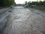
Mapocho River
Encyclopedia

Mapudungun
The Mapuche language, Mapudungun is a language isolate spoken in south-central Chile and west central Argentina by the Mapuche people. It is also spelled Mapuzugun and sometimes called Mapudungu or Araucanian...
Mapu chuco, " water that penetrates the land ") flows from the Andes
Andes
The Andes is the world's longest continental mountain range. It is a continual range of highlands along the western coast of South America. This range is about long, about to wide , and of an average height of about .Along its length, the Andes is split into several ranges, which are separated...
mountains onto the west and divides Chile
Chile
Chile ,officially the Republic of Chile , is a country in South America occupying a long, narrow coastal strip between the Andes mountains to the east and the Pacific Ocean to the west. It borders Peru to the north, Bolivia to the northeast, Argentina to the east, and the Drake Passage in the far...
's capital Santiago
Santiago, Chile
Santiago , also known as Santiago de Chile, is the capital and largest city of Chile, and the center of its largest conurbation . It is located in the country's central valley, at an elevation of above mean sea level...
in two.
Course
The Mapocho begins at the confluence of the San Francisco River and Molina River near 33.3735°S 70.397°W in the AndesAndes
The Andes is the world's longest continental mountain range. It is a continual range of highlands along the western coast of South America. This range is about long, about to wide , and of an average height of about .Along its length, the Andes is split into several ranges, which are separated...
. The main tributary of the former is Yerba Loca Creek, which drains the protected area that bears its same name. Molina River is fed by Iver Glacier, which lies on Cerro El Plomo
Cerro El Plomo
Cerro El Plomo is a mountain located in the Andes near Santiago, Chile. It is the largest peak visible from Santiago on clear days. The adequate season to climb this mountain is between November and March. In spring, soil conditions have abundant snow on the approach...
. A few kilometres westward from its source, the Mapocho receives the waters of the Arrayán Creek and enters to the urban area of Santiago.
The last western spurs of the Andes in this area force a change in the direction of the river, making that it begin to flow toward the south. In the vicinity of Cerro San Cristóbal
Cerro San Cristóbal
Cerro San Cristóbal is a hill in northern Santiago, Chile. It rises 880 m AMSL and about 300 m above the rest of Santiago; the peak is the second highest point in the city, after Cerro Renca. Its original indigenous name was Tupahue...
and just to the side of the Costanera Center
Costanera Center
Costanera Center is an ongoing development and construction of four skyscrapers being built in the Sanhattan financial district of Santiago, Chile by Cencosud...
project, the river collects the waters of the Canal San Carlos. From here, the river flows in a generally southwesterly direction to Plaza Baquedano area, which is a focal point of the city and the site where formerly the Mapocho split into two branches (the southern branch was turned into a promenade during the early years of the republic, now the Avenida Libertador General Bernardo O'Higgins avenue).
The river then turns northwest. In this portion of its course, some of the most meaningful landmarks of the city, arose along its southern bank. Those include the Parque Forestal
Parque Forestal
Parque Forestal is an urban park in the city of Santiago, Chile. The park was created on reclaimed land from the Mapocho River.Parque Forestal is located in the historical downtown of Santiago, west of Plaza Baquedano and east of Estación Mapocho...
, the Museo Nacional de Bellas Artes, the Mercado Central and the Estación Mapocho
Estación Mapocho
Built at the beginning of the 20th century, the Estación Mapocho was for a long time the hub for all rail traffic serving northern Chile, Valparaiso and Argentina. Built to celebrate the centennial of Chilean independence, the building has an obvious sentimental value that adds to its imposing...
. Farther northwest, two highway bridges connect the north and south sides of the river, which are part of the two branches of the Autopista Central
Autopista Central
Autopista Central is a modern, privatized, partially submerged highway in Chile. It is the longest of the Santiago highways with a length of .- External links :*...
.
Approximately at the longitude of the summit of Cerro Renca, the Mapocho changes its northwesterly flow to a southwesterly direction. From the southern portion of Comodoro Arturo Merino Benítez International Airport
Comodoro Arturo Merino Benítez International Airport
Comodoro Arturo Merino Benítez International Airport , also known as Pudahuel Airport and Santiago International Airport, located in Pudahuel, north-west of downtown Santiago, is Chile's largest aviation facility and the busiest international air passenger gateway to the country...
, the river turns south, to its outfall into the Maipo River
Maipo River
Maipo River is the main river flowing through Santiago Metropolitan Region, Chile. Its headwaters are on the west slope of Maipo volcano, in the Andes. Its most famous tributary is Mapocho River. The Maipo River is by far the major source of irrigation and potable water for the region.-Course:In...
.
Pollution
In March 2007, only 61% of the wastewater in Santiago was treated, though this increased to 71% by the end of the year.The Mapocho River remains contaminated by household, agricultural and industrial sewage, and by upstream copper-mining waste (from the several copper mines in the Andes, east of Santiago), being dumped unfiltered into the river. Laws force industry and local governments to process all their wastewater, but are loosely enforced. There are now a number of large wastewater processing and recycling plants under construction. There are ongoing plans to decontaminate the river and make it navigable.