
Map My Ancestors
Encyclopedia
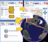
Map My Ancestors is an application for converting GEDCOM
files produced by genealogy software
into Keyhole Markup Language
(KML) files for viewing with KML-compatible programs such as Google Earth
or Google Maps
. It can also convert comma-separated values
(CSV) files produced by spreadsheet
or database
software into KML files.
The application identifies places in the source data and Geocode
s them to produce a list of latitudes and longitudes. The user has the opportunity to confirm map locations before viewing the data with Google Earth.
GEDCOM
GEDCOM, an acronym for GEnealogical Data COMmunication, is a proprietary and open de facto specification for exchanging genealogical data between different genealogy software...
files produced by genealogy software
Genealogy software
Genealogy software is computer software used to record, organize, and publish genealogical data. At a minimum, genealogy software collects the date and place of an individual's birth, marriage, and death, and stores the relationships of individuals to their parents, spouses, and children...
into Keyhole Markup Language
Keyhole Markup Language
Keyhole Markup Language is an XML notation for expressing geographic annotation and visualization within Internet-based, two-dimensional maps and three-dimensional Earth browsers. KML was developed for use with Google Earth, which was originally named Keyhole Earth Viewer. It was created by...
(KML) files for viewing with KML-compatible programs such as Google Earth
Google Earth
Google Earth is a virtual globe, map and geographical information program that was originally called EarthViewer 3D, and was created by Keyhole, Inc, a Central Intelligence Agency funded company acquired by Google in 2004 . It maps the Earth by the superimposition of images obtained from satellite...
or Google Maps
Google Maps
Google Maps is a web mapping service application and technology provided by Google, free , that powers many map-based services, including the Google Maps website, Google Ride Finder, Google Transit, and maps embedded on third-party websites via the Google Maps API...
. It can also convert comma-separated values
Comma-separated values
A comma-separated values file stores tabular data in plain-text form. As a result, such a file is easily human-readable ....
(CSV) files produced by spreadsheet
Spreadsheet
A spreadsheet is a computer application that simulates a paper accounting worksheet. It displays multiple cells usually in a two-dimensional matrix or grid consisting of rows and columns. Each cell contains alphanumeric text, numeric values or formulas...
or database
Database
A database is an organized collection of data for one or more purposes, usually in digital form. The data are typically organized to model relevant aspects of reality , in a way that supports processes requiring this information...
software into KML files.
The application identifies places in the source data and Geocode
Geocode
GEOCODE is a standardized all-natural number representation format specification for geospatial coordinate measurements that provide details of the exact location of geospatial point at, below, or above the surface of the earth at a specified moment of time.Geocode is patented under US Patents...
s them to produce a list of latitudes and longitudes. The user has the opportunity to confirm map locations before viewing the data with Google Earth.
Features
- Supports GEDCOM 5.5.1 draft's Latitude and Longitude extensions.
- GEDCOM custom tags created by Legacy Family TreeLegacy Family TreeLegacy Family Tree is genealogy software for Windows that assists family historians in tracking, organizing, printing, and sharing family history. The standard edition is distributed as freeware, with no restrictions, only requiring registration on the company's web site to download the software....
and RootsMagic are supported for latitude and longitude data.
See also
- Family Tree MappingFamily tree mappingFamily tree mapping is the process of geocoding places in family tree files to produce geospatial data suitable for viewing with a virtual globe or 2D mapping program.-Overview:...
- Google EarthGoogle EarthGoogle Earth is a virtual globe, map and geographical information program that was originally called EarthViewer 3D, and was created by Keyhole, Inc, a Central Intelligence Agency funded company acquired by Google in 2004 . It maps the Earth by the superimposition of images obtained from satellite...
Virtual GlobeVirtual globeA virtual globe is a 3D software model or representation of the Earth or another world. A virtual globe provides the user with the ability to freely move around in the virtual environment by changing the viewing angle and position. Compared to a conventional globe, virtual globes have the...
software - Bing Maps Platform