
Mamores
Encyclopedia
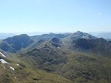
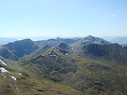
The Mamores are a group of mountains in the Lochaber
area of the Grampian Mountains
in the Scottish Highlands
. They form an east-west ridge approximately fifteen kilometres in length lying between Glen Nevis
to the north and Loch Leven
to the south.
 Ten of the ranges are classified as Munros; from west to east these are:
The main backbone of the Mamores stretches from Meall a' Chaorainn, a subsidiary top of Mullach nan Coirean, at the western end of the ridge, to Sgòr Eilde Beag, a top of Binnein Mòr some 10 km to the east. Three narrow arêtes run north from the main ridge connecting to the summits of Sgurr a' Mhàim, An Gearanach and Binnein Mòr. Beyond the eastern end of the ridge are two steep outlying peaks: Binnein Beag and Sgurr Eilde Mòr. Sandwiched between the remote upper section of Glen Nevis, and Lochs Eilde Mòr and Eilde Beag, these two peaks are the remotest in the Mamores.
For hillwalkers
the Mamores are accessible from either side - the village of Kinlochleven
lies on the southern side, whilst upper Glen Nevis gives access from the north. The full traverse is challenging, either as a long day for fit walkers or as a multi-day trip. Given the relative ease of access, several peaks can be combined to give a number of shorter day's walking. Probably the best known shorter route is the Ring of Steall, a circuit of the corrie
above Steall Falls. This route takes in four Munro peaks: Sgurr a' Mhàim, Am Bodach, Stob Coire a' Chàirn and An Gearanach.
Lochaber
District of Lochaber 1975 to 1996Highland council area shown as one of the council areas of ScotlandLochaber is one of the 16 ward management areas of the Highland Council of Scotland and one of eight former local government districts of the two-tier Highland region...
area of the Grampian Mountains
Grampian Mountains (Scotland)
The Grampian Mountains or Grampians are one of the three major mountain ranges in Scotland, occupying a considerable portion of the Scottish Highlands in northeast Scotland.-Extent:...
in the Scottish Highlands
Scottish Highlands
The Highlands is an historic region of Scotland. The area is sometimes referred to as the "Scottish Highlands". It was culturally distinguishable from the Lowlands from the later Middle Ages into the modern period, when Lowland Scots replaced Scottish Gaelic throughout most of the Lowlands...
. They form an east-west ridge approximately fifteen kilometres in length lying between Glen Nevis
Glen Nevis
Glen Nevis is a glen in Lochaber, Highland, Scotland, with Fort William at its foot. It is bordered to the south by the Mamore range, and to the north by the highest mountains in the British Isles: Ben Nevis, Càrn Mor Dearg, Aonach Mòr, and Aonach Beag...
to the north and Loch Leven
Loch Leven (Highlands)
Loch Leven 'is a sea loch on the west coast of Scotland. It is spelled Loch Lyon in Timothy Pont's map of the areaand is pronounced Li' un. There is a Leven in Lennox and another in Glen Lyon similarly pronounced...
to the south.
- Mullach nan CoireanMullach nan CoireanMullach nan Coirean is a Scottish mountain situated in the Mamores group of hills. It reaches a height of 939 metres and is located eight kilometres north-west of Kinlochleven...
(939 m) - Stob BànStob Bàn (Mamores)Stob Bàn is a Scottish mountain situated at the western end of the Mamores ridge, five and a half kilometres north-west of Kinlochleven. With a height of 999 metres it qualifies as a Munro...
(999 m) - Sgurr a' MhàimSgurr a' MhàimSgurr a’ Mhàim is a Scottish mountain situated five and a half kilometres north north-west of Kinlochleven in the Lochaber region of the Highland area.- Overview :...
(1099 m) - Am BodachAm BodachAm Bodach is a Scottish mountain which lies in the Mamores range, four kilometres north of Kinlochleven in the Highland council area.- Overview :...
(1032 m) - Stob Coire a' ChàirnStob Coire a' ChàirnStob Coire a’ Chàirn is a Scottish mountain situated in the Mamores range, 3.5 kilometres north of Kinlochleven. The mountain reaches a height of 981 metres and is regarded as one of the more modest peaks of the ten Munros in the Mamores, indeed for many years it was not named on OS maps...
(981 m) - An GearanachAn GearanachAn Gearanach is a Scottish mountain situated in the Mamore Forest, five and a half kilometres north of Kinlochleven in the Lochaber region of the Highland council area.- Overview :...
(982 m) - Na GruagaicheanNa GruagaicheanNa Gruagaichean is a Scottish mountain lying between Glen Nevis to the North and the village of Kinlochleven to the South in the Mamores mountain range in the Highlands, Scotland.-Overview:...
(1056 m) - Binnein MòrBinnein MòrBinnein Mòr is the highest peak in the Mamores, the range of mountains between Glen Nevis and Loch Leven in the Highlands of Scotland and lies five kilometres north north-east of Kinlochleven. The pyramidal summit of Binnein Mòr lies above the uninhabited upper section of Glen Nevis, north of the...
(1130 m) - Binnein BeagBinnein BeagBinnein Beag is a Scottish mountain situated at the eastern end of the Mamores range seven kilometres north north-east of Kinlochleven. It is a relatively small, conical peak which is connected to its larger neighbour, Binnein Mòr, by a bealach at 750m. Despite being overshadowed by Binnein Mòr, it...
(943 m) - Sgurr Eilde MòrSgurr Eilde MòrSgurr Eilde Mòr is a Scottish mountain situated in the Mamores range, 6 kilometers north-east of Kinlochleven. It is a steep, conical peak of scree and quartzite boulders, capped with a layer of schist. With a height of 1010 m it is classed as a Munro, so is popular with hillwalkers...
(1010 m)
The main backbone of the Mamores stretches from Meall a' Chaorainn, a subsidiary top of Mullach nan Coirean, at the western end of the ridge, to Sgòr Eilde Beag, a top of Binnein Mòr some 10 km to the east. Three narrow arêtes run north from the main ridge connecting to the summits of Sgurr a' Mhàim, An Gearanach and Binnein Mòr. Beyond the eastern end of the ridge are two steep outlying peaks: Binnein Beag and Sgurr Eilde Mòr. Sandwiched between the remote upper section of Glen Nevis, and Lochs Eilde Mòr and Eilde Beag, these two peaks are the remotest in the Mamores.
For hillwalkers
Hillwalking
In the British Isles, the terms hillwalking or fellwalking are commonly used to describe the recreational outdoor activity of walking on hills and mountains, often with the intention of visiting their summits...
the Mamores are accessible from either side - the village of Kinlochleven
Kinlochleven
Kinlochleven is a village in Lochaber, in the Scottish Highlands and lies at the eastern end of Loch Leven, a sea loch cutting into the western Scottish Highlands. To the north lie the Mamores ridge; to the south lie the mountains flanking Glen Coe...
lies on the southern side, whilst upper Glen Nevis gives access from the north. The full traverse is challenging, either as a long day for fit walkers or as a multi-day trip. Given the relative ease of access, several peaks can be combined to give a number of shorter day's walking. Probably the best known shorter route is the Ring of Steall, a circuit of the corrie
Cirque
Cirque may refer to:* Cirque, a geological formation* Makhtesh, an erosional landform found in the Negev desert of Israel and Sinai of Egypt*Cirque , an album by Biosphere* Cirque Corporation, a company that makes touchpads...
above Steall Falls. This route takes in four Munro peaks: Sgurr a' Mhàim, Am Bodach, Stob Coire a' Chàirn and An Gearanach.