

Malinao, Albay
Encyclopedia
Philippines
The Philippines , officially known as the Republic of the Philippines , is a country in Southeast Asia in the western Pacific Ocean. To its north across the Luzon Strait lies Taiwan. West across the South China Sea sits Vietnam...
. According to the 2007 census, it has a population of 39,516 people in 8,418 households.
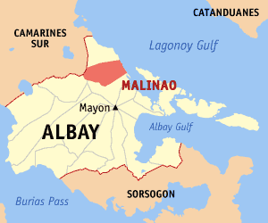
MALINAO, the prime rice granary of the first district of Albay, is a third class town located the northeastern rim of the southern-most tip of Luzon, which forms the Bicol Peninsula. To its north is the municipality of Tiwi; to its south, the City of Tabaco and to its west is the province of Camarines Sur.
The town occupies a narrow stretch of plains hemmed in by Lagonoy Gulf in the east and Mount Malinao on the west.
The mountain ranges of Malinao, a dormant volcano whose highest altitude is estimated at 1,584 meters above sea level, dominate a large part of the town’s total land area, which is 10,750 hectares or 107.50 square kilometers.
The world renowned Mayon Volcano lies southwest of Malinao, providing the town a majestic ambiance for its agricultural setup.
The town is 587 kilometers south of Manila, 32 kilometers north of Albay Provincial Capitol (the Provincial Seat of Government) and 5 kilometers north of Tabaco City, The leading trade center in the first district of Albay Province with an international port. Ther are twenty-nine (29) barangays, twenty-five (25) of which are rural areas and the remaining four (4) are urban.;
The total population climbed to 33,872 in 1995, an increase of 2359 individuals or 6.94% for five (5) years with an average households as of 2000.
Of these, less than ten (10) per cent or 3,301 reside in the urban barangays of Bagumbayan, Pawa, Payahan and Poblacion. The rest of the constituents meanwhile stay on the rural barangays, namely: Awang, Bagatangki, Balading, Balza, Bariw, Baybay, Bulang, Burabod, Cabunturan, Comun, Diaro, Estancia, Jonop, Labnig, Libod, Malolos, matalipni, Ogob, Quinarabasahan, Sta. Elena, Soa, Sugcad, Tagoytoy, Tanawan and Tuliw. The densest areas are Estancia, Labnig and Balading while Awang and Bagatangki are the least populated in the rural areas.
Majority of its population engages in agriculture and other agri-related enterprise.
The population thus, vis-à-vis land resources is yet blessed with having an abundant area for various allocation of land uses which nowadays considered a precious gem.
Brief history
The municipality of Malinao was founded in year 1600 or 79 years after Magellan landed in Cebu and planted the first Christian Cross.Between year 1600 to year 1616, Malinao was then part of the Diocese of Cagsawa (now Daraga). It became an independent bisita or sitio attached to Sawangan (now Legazpi City) until the year 1619 when separate religious administration was exercised with Rev. Francisco de Sta. Ana, OFM, as first pastor.
Local folklore speaks of a plant once rich in this town called "ALINAO." The prefix "MA," which denotes abundance of something in local dialect, was affixed by the natives in referring to the place abundant with Alinao, thus Ma-alinao and later corrupted to Malinao.
It was however in year 1916 when according to legendary account, Malinao got its name. A siege by Moros on town resulted in the abduction of seven women. Miraculously, the boat sank within the jurisdictional waters of Malinao and on that same spot in the sea across the island of natunawan because of the women's fervent prayer in canticles and "tarahades" or clear thoughts for the Blessed Virgin to sink the boat. From these "clear thoughts" of the seven women translated in Bicol dialect as "malinao na isip." The name of Malinao was given to the Municipality. It has since then the tradition among the residents particularly the women, to sing the canticles or tarahades in times of crisis or calamities or when they want to drive away epidemics and misfortunes.
Other information
LocationMalinao lies at the North-Eastern rim of the Southernmost tip of Luzon, which forms the Bicol Peninsula. It is 587 km. from Manila, 32 km. from Legazpi, and 5 km. from Tabaco.
Classification
Third Class Municipality
Political Boundaries
North: Municipality of Tiwi
South: Tabaco City
East: Lagunoy Gulf
West: Municipality of Buhi and Polangui
No. of Barangays: 29
Upland Barangays: 12
Lowland Barangays: 13
Coastal Barangays: 4
Physical Characteristics
Total Land Area: 10,750 hectares
Public Land: 72.60 hectares
Built-Up/Residential: 985.76 hectares
Agricultural: 5750.34 hectares
Irrigable - 2250 has.
Irrigated - 1873 has.
Forest: 1569.30 hectares
Timberland - 21.00 has.
2nd growth - 615.00 has.
Watershed - 870.00 has.
Mangrove/swap - 63.30 has.
Grassland/Shrub/Pasture: 15.00 hectares
Idle/Vacant Lot: 49.00 hectares
Nipas: 2308.00 hectares
Demographic Characteristics
Population (2007 NSO Survey): 39,516
No. of Households (2007 Brgy. Data: 8,418
Population Density (person/ha): 3.68
Average Household Size: 5
Communication Facilities
Telegraph: 1
Post Office: 1
Cellsites: 3 (Globe, Smart, Sun)
Power Supply (ALECO)
No. of Energized Barangays - 29
Unenergized Households - 4%
Major Agricultural Products
Major Crops
Palay (2 cropping)
Irrigated - 3709.44 has. - 11,754.00 MT
Rainfed - 635.35 has. - 1,992.90 MT
Abaca - 1260 has. - 252.00 MT
Coconut - 186 has. - 54.87 MT
Root Crops
Camote - 4.85 has. - 48.50 MT
Cassava - 3.77 has. - 45.50 MT
Gabi - 1.50 has. - 4.50 MT
Vegetable (Leafy) - 5.193 has. - 9.049 MT
Fruit Vegetable - 21.869 has. - 93.95 MT
Fruits - 36.29 has. - 229.4 MT
Sugarcane - 10 has. - 0.84 MT
Barangays
Malinao is politically subdivided into 29 barangayBarangay
A barangay is the smallest administrative division in the Philippines and is the native Filipino term for a village, district or ward...
s.
| No. | BARANGAY | BARANGAY CAPTAIN | SK CHAIRPERSON |
|---|---|---|---|
| 1 | Awang | Yolanda C. Matias | Shiela Marie S. Marudo |
| 2 | Bagatangki | Ramon B. San Juan | Rosaly C. Coralde |
| 3 | Bagumbayan | Marita E. Cansilao | Mariejoy A. Cano |
| 4 | Balading | Ofelia C. Bigata | Henrietta C. Bio |
| 5 | Balza | Nelson G. Rico | Stuart C. Brutas |
| 6 | Bariw | Justo C. Cornelio | Jessica C. Carillo |
| 7 | Baybay | Jose M. Cestina | Marilou C. Cepres |
| 8 | Bulang | Romeo P. Ceneta | Nimfa C. Coprada |
| 9 | Burabod | Clarita C. Coper | Jeffrey C. Avila |
| 10 | Cabunturan | Harrison B. Molo | Gerard B. Malagueño |
| 11 | Comun | Abundio D. Camu | Janice L. Bataller |
| 12 | Diaro | Natividad C. Cascabel | Aaron C. Cascabel |
| 13 | Estancia | Susan B. Nabor | Mariedel Nabor |
| 14 | Jonop | Josefina C. Florentino | Alian Ann C. Carullo |
| 15 | Labnig | Joel P. Cardano | Audrey Nichol O. Cargullo |
| 16 | Libod | Jose B. Bragais Sr. | Fernando P. Callada Jr. |
| 17 | Malolos | Nardito C. Carpina | Mian C. Capitin |
| 18 | Matalipni | Bernardo C. Cañeza | Melvin P. Callo |
| 19 | Ogob | Antonio C. Diaz | Neil B. Basmayor |
| 20 | Pawa | Antonio C. Celamor | Niña Ritter |
| 21 | Payahan | Rex B. Cruz | Jhane C. Cestina |
| 22 | Poblacion | Agnes B. Nuñez | Aila Marie C. Almazora |
| 23 | Quinarabasahan | Jason B. Cornel | Sandy B. Cuentas |
| 24 | Sta. Elena | Jesus C. Castelo | Jervis M. Ceperez |
| 25 | Soa | Salvador C. Caneo, Sr. | Lourdes C. Caneo |
| 26 | Sugcad | Epifanio C. Conde | Edronel Albaniel |
| 27 | Tagoytoy | Heracleo U. Diaz, Jr. | Maricris B. Regalado |
| 28 | Tanawan | Isidro C. Ceriola | Krisel C. Ceriola |
| 29 | Tuliw | Policarpio B. Ceneta | Analiza C. Pongan |