

Malanggad
Encyclopedia
Raigad district
Raigad District , also known as Raigarh District, is a district in the Indian state of Maharashtra. It is located in the Konkan region. The district was renamed after Raigad, the fort which was the former capital of the Maratha leader Shivaji, and is located in the interior regions of the district,...
, Maharashtra
Maharashtra
Maharashtra is a state located in India. It is the second most populous after Uttar Pradesh and third largest state by area in India...
. It has an elevation of 789 m above sea level.
Major features
Dargah
A Dargah is a Sufi shrine built over the grave of a revered religious figure, often a Sufi saint. Local Muslims visit the shrine known as . Dargahs are often associated with Sufi meeting rooms and hostels, known as khanqah...
of a Sufi saint - Haji Malang. At the other end of the plateau is the Panchi Pir which lies almost at the edge of the rock and is named after the five pirs who accompanied Haji Malang. This plateaus is called Pir Machi.
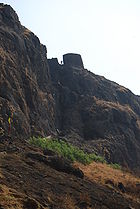
The next higher level is called the Sone Machi as it is the lower part of the fort. This is a projection of rock with is 70 feet broad and 100 feet long. It is shaped like an elephant trunk. It has a parapet wall with bastions on two sides but there are no machicolation
Machicolation
A machicolation is a floor opening between the supporting corbels of a battlement, through which stones, or other objects, could be dropped on attackers at the base of a defensive wall. The design was developed in the Middle Ages when the Norman crusaders returned. A machicolated battlement...
s to fire at the an invading army.
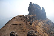
The highest level is the Citadel which is 200 yards long and 70 yards broad. This is the summit of the hill and has no fortifications. The water supply is from five cisterns at the top of the hill with a copper pipe to carry water to the lower levels.
Malanggad is different from other forts in Maharashtra. Whereas other forts have several gates and multiple watchtowers, Malanggad has only one small gate and one watchtower which is not independent but a part of the main gate itself. With a wall with no machicolations to fire at the enemy and no fortifications, Malanggad is one of the few forts to depend completely on natural aspects of the hill to defend itself.
History
Malanggad was built in the 7th century by Raja Nagal probably during the Yadav period. His is the oldest name associated with Malanggad and he is said to have improved access to the hill by means of an iron bridge.On 4 August, 1780, British troops under a Captain Abington, stormed Malanggad and took the Sone Machi(the middle level). The Marathas who held the fort then fled to the Citadel(the highest level) and managed to cut off his communication with Kalyan. Reinforcements arrrived in early October as Coloner Hartley and Captain Jameson and their troops advanced on Malanggad and finally defeated the Marathas. Thus in 1780, the English established themselves in Malanggad but they left after two years. The Peshwa
Peshwa
A Peshwa is the titular equivalent of a modern Prime Minister. Emporer Shivaji created the Peshwa designation in order to more effectively delegate administrative duties during the growth of the Maratha Empire. Prior to 1749, Peshwas held office for 8-9 years and controlled the Maratha army...
attributed this to the "power of the saint" and he sent to the shrine a cloth of gold trimmed with pearls set on silver posts.
After Konkan ceded to the British Raj
British Raj
British Raj was the British rule in the Indian subcontinent between 1858 and 1947; The term can also refer to the period of dominion...
in 1817, Malanggad fort resisted for several months. However, in January 1818 by a small force under a Colonel Kennedy, scaled the mountain and brought Malanggad under British rule. There is a local legend that in 1834 some Europeans, who went into the shrine with their shoes, were attacked by bees. It is believed that it belongs to the hindu saint Navnath panth and muslims acquired the fort in the name of hazi malang. The presence of the 'fish' symbolism at the tip of the dome is argued as a sign of 'machindranath' of the nath panth tradition.

Current use
On the February full moon (Magh Shuddh' Purnima) a large fair is attended by the people of all faiths from KalyanKalyan
Kalyan is a city in Thane district of Maharashtra, and a major railway station lying at the junction of the north-east and south-east lines of the suburban Mumbai division of the Central Railway, 53 km north-east of Mumbai. Kalyan is also a major Taluka place, a tehsil of the Thane district...
, Panvel
Panvel
Panvel is city and a municipal council in Raigad district in the state of Maharashtra. Panvel is also known as the gateway of Konkan region. It adjoins Navi Mumbai, and is just after the Thane district border. Panvel is located on the Yashwantrao Chavan Expressway about 21 kilometres from...
, Thane
Thane
Thane , is a city in Maharashtra, India, part of the Mumbai Metropolitan Region, northeastern suburb of Mumbai at the head of the Thane Creek. It is the administrative headquarters of Thane district. On 16 April 1853, G.I.P...
, and Mumbai
Mumbai
Mumbai , formerly known as Bombay in English, is the capital of the Indian state of Maharashtra. It is the most populous city in India, and the fourth most populous city in the world, with a total metropolitan area population of approximately 20.5 million...
. The annual pilgrimage to the shrine is during May. On reaching the top the pilgrims perform three rituals - washing their hands and feet in the large water cistern, eating wild figs from the trees growing around the shrine and throwing stones at a rock pinnacle on the south west side.