

Mahasthangarh
Encyclopedia
Bangladesh
Bangladesh , officially the People's Republic of Bangladesh is a sovereign state located in South Asia. It is bordered by India on all sides except for a small border with Burma to the far southeast and by the Bay of Bengal to the south...
. The village Mahasthan in Shibganj thana of Bogra District
Bogra District
Bogra is a northern district of Bangladesh, in the Rajshahi Division. It is called the gateway to the north Bengal. It is an industrial city where many small and mid sized industries are housed. Bogra district was a part of the ancient Pundravardhana territory and Bogra was the capital of...
contains the remains of an ancient city which was called Pundranagara or Paundravardhanapura in the territory of Pundravardhana
Pundravardhana
This article is about the historical territory. For the Mahabharata kingdom see Pundra KingdomPundravardhana , was a territory located in North Bengal in ancient times, home of the Pundra, a group of people speaking languages not of the Indo-European family.-Etymology:There are several theories...
. A limestone
Limestone
Limestone is a sedimentary rock composed largely of the minerals calcite and aragonite, which are different crystal forms of calcium carbonate . Many limestones are composed from skeletal fragments of marine organisms such as coral or foraminifera....
slab bearing six lines in Prakrit
Prakrit
Prakrit is the name for a group of Middle Indic, Indo-Aryan languages, derived from Old Indic dialects. The word itself has a flexible definition, being defined sometimes as, "original, natural, artless, normal, ordinary, usual", or "vernacular", in contrast to the literary and religious...
in Brahmi script
Brāhmī script
Brāhmī is the modern name given to the oldest members of the Brahmic family of scripts. The best-known Brāhmī inscriptions are the rock-cut edicts of Ashoka in north-central India, dated to the 3rd century BCE. These are traditionally considered to be early known examples of Brāhmī writing...
, discovered in 1931, dates Mahasthangarh to at least the 3rd century BC. The fortified area was in use till the 18th century AD.
Together with the ancient and mediaeval ruins, the mazhar (holy tomb) of Shah Sultan Balkhi Mahisawar
Shah Sultan Balkhi Mahisawar
Shah Sultan Balkhi Mahisawar was a 14th century Muslim saint. He preached Islam in Bogra District or Pundravardhana.-Who was he:...
built at site of a Hindu temple is located at Mahasthangarh. He was a dervish
Dervish
A Dervish or Darvesh is someone treading a Sufi Muslim ascetic path or "Tariqah", known for their extreme poverty and austerity, similar to mendicant friars in Christianity or Hindu/Buddhist/Jain sadhus.-Etymology:The Persian word darvīsh is of ancient origin and descends from a Proto-Iranian...
(holy person devoted to Islam) of royal lineage who came to the Mahasthangarh area, with the objective of spreading Islam among non-Muslims. He converted the people of the area to Islam and settled there.
Etymology
Mahasthan means a place that has excellent sanctity and garh means fort. Mahasthan was first mentioned in a SanskritSanskrit
Sanskrit , is a historical Indo-Aryan language and the primary liturgical language of Hinduism, Jainism and Buddhism.Buddhism: besides Pali, see Buddhist Hybrid Sanskrit Today, it is listed as one of the 22 scheduled languages of India and is an official language of the state of Uttarakhand...
text of the 13th century entitled Vallalcharita. It is also mentioned in an anonymous text Karatoya mahatmya,, circumstantially placed in 12th-13th century. The same text also mentions two more names to mean the same place – Pundrakshetra, land of the Pundras, and Pundranagara, city of the Pundras. In 1685, an administrative decree mentioned the place as Mastangarh, a mixture of Sanskrit and Persian
Persian language
Persian is an Iranian language within the Indo-Iranian branch of the Indo-European languages. It is primarily spoken in Iran, Afghanistan, Tajikistan and countries which historically came under Persian influence...
meaning fortified place of an auspicious personage. Subsequent discoveries have confirmed that the earlier name was Pundranagara or Paundravardhanapura, and that the present name of Mahasthangarh is of later origin.
Geography
Mahasthangarh, the ancient capital of PundravardhanaPundravardhana
This article is about the historical territory. For the Mahabharata kingdom see Pundra KingdomPundravardhana , was a territory located in North Bengal in ancient times, home of the Pundra, a group of people speaking languages not of the Indo-European family.-Etymology:There are several theories...
is located 11 km (6.8 mi) north of Bogra
Bogra District
Bogra is a northern district of Bangladesh, in the Rajshahi Division. It is called the gateway to the north Bengal. It is an industrial city where many small and mid sized industries are housed. Bogra district was a part of the ancient Pundravardhana territory and Bogra was the capital of...
on the Bogra
Bogra District
Bogra is a northern district of Bangladesh, in the Rajshahi Division. It is called the gateway to the north Bengal. It is an industrial city where many small and mid sized industries are housed. Bogra district was a part of the ancient Pundravardhana territory and Bogra was the capital of...
-Rangpur
Rangpur District
The district of Rangpur have 4924 mosques, 480 temples, 43 churches and six tombs.In an anthropologic view most people of Rangpur are having Rajbagshi blood in their veins...
highway, with a feeder road (running along the eastern side of the ramparts of the citadel for 1.5 km) leading to Jahajghata and site museum. Buses are available for Bogra from Dhaka
Dhaka
Dhaka is the capital of Bangladesh and the principal city of Dhaka Division. Dhaka is a megacity and one of the major cities of South Asia. Located on the banks of the Buriganga River, Dhaka, along with its metropolitan area, had a population of over 15 million in 2010, making it the largest city...
and take 4½ hours for the journey via Bangabandhu Jamuna Bridge
Jamuna Bridge
Bangabandhu Bridge, also called the Jamuna Multi-purpose Bridge , is a bridge opened in Bangladesh in June 1998. It connects Bhuapur on the Jamuna River's east bank to Sirajganj on its west bank. It was the 11th longest bridge in the world when constructed in 1998 and currently the 6th longest...
across the Jamuna River. Buses are available from Bogra
Bogra District
Bogra is a northern district of Bangladesh, in the Rajshahi Division. It is called the gateway to the north Bengal. It is an industrial city where many small and mid sized industries are housed. Bogra district was a part of the ancient Pundravardhana territory and Bogra was the capital of...
to Mahasthangarh. Rickshaws are available for local movement. Hired transport is available at Dhaka/ Bogra. Accommodation is available at Bogra. When travelling in a hired car, one can return to Dhaka the same day, unless somebody has a plan to visit Somapura Mahavihara
Somapura Mahavihara
Somapura Mahavihara in Paharpur, Badalgachhi Upazila, Naogaon District, Bangladesh is among the best known Buddhist viharas in the Indian Subcontinent and is one of the most important archeological sites in the country...
at Paharpur in the district of Naogaon and other places, or engage in a detailed study.
It is believed that the location for the city in the area was decided upon because it is one of the highest areas in Bangladesh. The land in the region is almost 36 m above sea level, whereas Dhaka
Dhaka
Dhaka is the capital of Bangladesh and the principal city of Dhaka Division. Dhaka is a megacity and one of the major cities of South Asia. Located on the banks of the Buriganga River, Dhaka, along with its metropolitan area, had a population of over 15 million in 2010, making it the largest city...
, the capital of Bangladesh, is around 6 m above sea level. Another reason for choosing this place was the position and size of the Karatoya
Karatoya River
Karatoya River , a small stream in Rajshahi Division of Bangladesh, was once a large and sacred river. A channel of it presently flows by the ancient ruins of Mahasthangarh in Bogra District. The Karatoya mahatmya bears testimony to its past greatness...
, which seemed to be as wide as the sea.
Mahasthangarh stands on the red soil of the Barind Tract
Barind Tract
Barind Tract is the largest Pleistocene era pysiographic unit in Bangladesh and the Bengal Basin. It covers most of Dinajpur, Rangpur, Pabna, Rajshahi, Bogra, and Joypurhat districts of Rajshahi Division...
which is slightly elevated within the largely alluvium area. The elevation of 15 to 25 metres above the surrounding areas makes it a relatively flood free physiographic unit.
Discovery
Several personalities contributed to the discovery and identification of the ruins at Mahasthangarh. F. Buchanan Hamilton was the first to locate and visit Mahasthangarh in 1808, C.J.O’Donnell, E.V.Westmacott, and Baveridge followed. Alexander Cunningham was the first to identify the place as the capital of PundravardhanaPundravardhana
This article is about the historical territory. For the Mahabharata kingdom see Pundra KingdomPundravardhana , was a territory located in North Bengal in ancient times, home of the Pundra, a group of people speaking languages not of the Indo-European family.-Etymology:There are several theories...
. He visited the site in 1889.
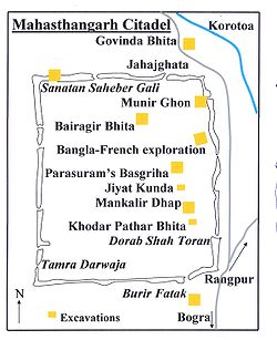
Citadel
The citadel (see map alongside), the fortified heart of the ancient city, is rectangular in plan, measuring roughly 1.523 km long from north to south, and 1.371 km from east to west, with high and wide ramparts in all its wings. The KaratoyaKaratoya River
Karatoya River , a small stream in Rajshahi Division of Bangladesh, was once a large and sacred river. A channel of it presently flows by the ancient ruins of Mahasthangarh in Bogra District. The Karatoya mahatmya bears testimony to its past greatness...
, once a mighty river but now a small stream, flows on its east.
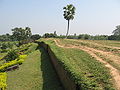
Till the 1920s, when excavations started, the inside of the citadel was higher than the surrounding areas by over 4 metres and was dotted with several straggling elevated pieces of land. The rampart looked like a jungle clad mud rampart with forced openings at several points. The rampart was 11–13 metres higher than the surrounding area. At its south-east corner stood a mazhar (holy tomb). A later day mosque (built in 1718-19) was also there.
At present there are several mounds and structural vestiges inside the fortifications. Of these a few of note are: Jiat Kunda (well possessing life giving power), Mankalir Dhap (place consecrated to Mankali), Parasuramer Basgriha (palace of a king named Parasuram), Bairagir Bhita (palace of a female anchorite), Khodar Pathar Bhita (place of stone bestowed by God), and Munir Ghon (a bastion). There are some gateways at different points: Kata Duar (in the north), Dorab Shah Toran (in the east), Burir Fatak (in the south), and Tamra Dawaza (in the west) At the north-eastern corner there is a flight of steps (a later addition) that goes by the name of Jahajghata. A little beyond Jahajghata and on the banks of the Karatoya is Govinda Bhita (a temple dedicated to Govinda). In front of it is the site museum, displaying some of the representative findings. Beside it is a rest house.
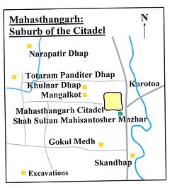
Suburb of the citadel
Besides the fortified area, there are around a hundred mounds spread over an area with a radius of 9 km. (See map alongside).Excavated mounds:
- Gobhindo Bhita, a temple close to the north-eastern corner of the fortified area.
- Khulnar Dhap, a temple 1 km to the west of the fortified area.
- Mangalkot, a temple 400 m to the south of Khulnar Dhap.
- Godaibari Dhap, a temple 1 km to the south of Khulnar Dhap.
- Totorom Panditer Dhap, a monastery 4 km to the north-west of the fortified area.
- Noropotir Dhap (Boshu Bhihara), a group of monasteries 1 km to the north-west of Totorom Ponditer Dhap (said to be the place where Po-shippo Bhihara mentioned by XuanzangXuanzangXuanzang was a famous Chinese Buddhist monk, scholar, traveler, and translator who described the interaction between China and India in the early Tang period...
(Hieun Tsang) was located). - Gokul Medh (Lokhindorer Bashar Ghor), a temple 3 km to the south of the fortified area (it is a small distance off the road from Bogra to Mahasthangarh).
- Shkonder Dhap, a temple 2 km to the south-east of Gokul Medh.
Major unexcavated mounds:
- Siladebhir Ghat.
- Chunoru Dighi Dhap.
- Kaibilki Dhap.
- Juraintala.
- Poroshuramer Shobhabati.
- Balai Dhap.
- Prochir Dhibi.
- Kanchir Hari Dhibi.
- Lohonar Dhap.
- Khujar Dhap.
- Doshatina Dhap.
- Dhoniker Dhap.
- Mondirir Dorgah.
- Bishmordana Dhibi.
- Malinar Dhap.
- Malpukuria Dhap.
- Yogir Dhap.
- Podmobhatir Dhap.
- Kanai Dhap.
- Dulu Mojhir Bhita.
- Podda Debhir Bhita.
- Rastala Dhap.
- Shoshitola Dhap.
- Dhonbandhor Dhap.
- Chader Dhap.
- Shindinath Dhap.
- Shalibahon Rajar Kacharibari Dhipi.
- Kacher Angina.
- Mongolnather Dhap.
- ChhoutoTengra/ Babur Dhap/ Kethar Dhap.
- Boro Tengra/ Shonyashir Dhap.
Excavations
Systematic archaeological excavation of Mahasthangarh was first started in 1928-29 under the guidance of K.N.Dikshit of the Archaeological Survey of India. The areas around Jahajghata, Munir Ghon and Bairagir Bhita were explored. Excavation was resumed in 1934-36 at Bairagir Bhita and Govinda Bhita. Excavation was carried out in 1960s around the Mazhar, Parasuramer Prasad, Mankalir Dhap, Jiat Kunda and in a part of the northern rampart. In the next phase excavation was carried out sporadically in parts of the east and north ramparts but the final report is yet to be published. In the period 1992-98 excavation was conducted in the area lying between Bairagir Bhita and the gateway exposed in 1991 as a Bangla-Franco joint venture, which is now in its second phase with excavation around the mazhar in the western side of the citadel.Movable antiquities
The excavations have led to the recovery of a large number of items, a few of which are listed here.Inscriptions: A 4.4 cm x 5.7 cm lime stone slab bearing six lines in Prakrit
Prakrit
Prakrit is the name for a group of Middle Indic, Indo-Aryan languages, derived from Old Indic dialects. The word itself has a flexible definition, being defined sometimes as, "original, natural, artless, normal, ordinary, usual", or "vernacular", in contrast to the literary and religious...
in Brahmi
Brāhmī script
Brāhmī is the modern name given to the oldest members of the Brahmic family of scripts. The best-known Brāhmī inscriptions are the rock-cut edicts of Ashoka in north-central India, dated to the 3rd century BCE. These are traditionally considered to be early known examples of Brāhmī writing...
script, discovered accidentally by a day labourer in 1931 was an important find. The text appears to be a royal order of Magadh, possibly during the rule of Asoka. It dates the antiquity of Mahasthangarh to 3rd century BC. An Arabic inscriptional slab of 1300-1301 discovered in 1911-12 mentions the erection of a tomb in honour of Numar Khan, who was a Meer-e-Vahar (lieutenant of the naval fleet). A Persian inscriptional slab of 1718-19 records the construction of a mosque during the reign of the Mughal emperor Farrukhshiyar.
Coins: Silver punch marked coins are datable to a period between the 4th century BC and the 1st-2nd century AD. Some uninscribed copper cast coins have been found. Two Gupta period coins have been reported from a nearby village named Vamanpara. A number of coins belonging to the sultans of 14th-15th century and British East India Company
British East India Company
The East India Company was an early English joint-stock company that was formed initially for pursuing trade with the East Indies, but that ended up trading mainly with the Indian subcontinent and China...
have been found.
Ceramics: Mostly represented by a vast number of shards.
Sculpture: A 5th century Buddha stone sculpture recovered from Vasu Vihara, a Lokesvara stone sculpture showing blending of Visnu and Avalokitsvara, salvaged from neighbouring Namuja village, a number sand stone door-frames, pillars and lintels (datable to 5th-12th century), numerous Buddha bronze sculpture datable to 10th-11th century, a terracotta Surya discovered at Mankalir Bhita, and numerous other pieces.
Terracotta Plaques: A number of terracotta plaques have been discovered.
Many of these are on display in the site museum, which is open Sunday to Thursday summer:10 am to 6 pm, winter:9 am to 5 pm. Recess:1-2 pm, Friday recess is from 12.30 to 2.30, opens at 9 am in summer, other timings same. Summer timings 1 April to 30 September, winter timings 1 October to 30 March. Books on Mahasthangarh and other archaeological sites in Bangladesh (in Bengali and English) are available at the ticket counter for the site museum.
Inside the citadel
Bairagir Bhita: Constructed/ reconstructed in four periods: 4th-5th century AD, 6th-7th century, 9th-10th century, and 11th century. Excavations have revealed impoverished base ruins resembling temples. Two sculptured sand stone pillars have been recovered.Khodarpathar Bhita: Some pieces of stone carved with transcendent Buddha along with devotees in anjali (kneeling with folded hands) recovered.
Parasuramer Prasad: Contains remains of three occupation periods - 8th century AD findings include stone Visnupatta of Pala period, 15th- 16th century findings include some glazed shreds of Muslim origin, and the third period has revealed two coins of the British East India Company
British East India Company
The East India Company was an early English joint-stock company that was formed initially for pursuing trade with the East Indies, but that ended up trading mainly with the Indian subcontinent and China...
issued in 1835 and 1853.
Mankalir Dhap: terracotta plaques, bronze Ganesha
Ganesha
Ganesha , also spelled Ganesa or Ganesh, also known as Ganapati , Vinayaka , and Pillaiyar , is one of the deities best-known and most widely worshipped in the Hindu pantheon. His image is found throughout India and Nepal. Hindu sects worship him regardless of affiliations...
, bronze Garuda
Garuda
The Garuda is a large mythical bird or bird-like creature that appears in both Hindu and Buddhist mythology.From an Indian perspective, Garuda is the Hindu name for the constellation Aquila and...
etc. were discovered. Base ruins of a 15-domed mosque (15th-16th century) was revealed.
Bangla
Bangladesh
Bangladesh , officially the People's Republic of Bangladesh is a sovereign state located in South Asia. It is bordered by India on all sides except for a small border with Burma to the far southeast and by the Bay of Bengal to the south...
-Franco
France
The French Republic , The French Republic , The French Republic , (commonly known as France , is a unitary semi-presidential republic in Western Europe with several overseas territories and islands located on other continents and in the Indian, Pacific, and Atlantic oceans. Metropolitan France...
joint venture: Excavations have revealed 18 archaeological layers, ranging from 5th century BC to 12th century AD, till virgin soil at a depth of around 17 m.
Outside the citadel
Govinda Bhita: Situated 185 m north-east of Jahajghata and opposite the site museum. Remains dated from 3rd century BC to 15th century AD. Base remains of two temples have been exposed.Totaram Panditer Dhap: Situated in the village Vihara, about 6 km north-west of the ciradel. Structural remains of a damaged monastery have been exposed.
Narapatir Dhap: Situated in the village Basu Vihara, 1.5 km north-west of Totaram Panditer Dhap. Base remains of two monasteries and a temple have been exposed. Cunningham identified this place as the one visited by Xuanzang
Xuanzang
Xuanzang was a famous Chinese Buddhist monk, scholar, traveler, and translator who described the interaction between China and India in the early Tang period...
(Hiuen Tsang) in the 7th century AD.
Gokul Medh: Also known as Behular Basar Ghar or Lakshindarer Medh, situated in the village Gokul, 3 km to the south of the citadel, off the Bogra-Rangpur road, connected by a narrow motorable road about 1 km. Excavations in 1934-36 revealed a terraced podium with 172 rectangular blind cells. It is dated 6th-7th century. Local mythology associates it with legendary Lakshmindara-Behula. The village Gokul also has several other mound Kansr Dhap has been excavated.
Skandher Dhap: Situated in village Baghopara on the Bogra-Rangpur road, 3.5 km to the south of the citadel, a sandstone Kartika
Kartika
Kartika or Karthika may refer to:* alternative transliteration of Kartik** Kartikeya, the son of Shiva in the Indian mythology* alternative transliteration of Karthika, a feminine name in Indian languages** Kartika Rane, Indian actress...
was found and structural vestiges of a damaged building were revealed. It is believed to be the remains of Skandha Mandira (temple consecrated to Kartika), mentioned in Karatoya mahatmya, as well as Kalhan’s Rajatarangin, written in 1149-50. There also are references to Skandhnagara as a suburb of Pundranagara. Baghopara village has three other mounds.
Khulnar Dhap: Situated in village Chenghispur, 700 m west of the north-west corner of the citadel has revealed remains of a temple. The mound is named after Khullana, wife of Chand Sadagar
Chand Sadagar
Chand Sadagar, , , was a rich and powerful merchant of Champak Nagar in ancient India. Bipradas Pipilai gave an account in his Manasamangal about the merchant ship of the trader Chand Saudagar proceeding to the sea, passing through Saptagram and Tribeni, the tri junction of the Ganges, Saraswati...
.
From the present findings it can be deduced that there was a city called Pundravardhana
Pundravardhana
This article is about the historical territory. For the Mahabharata kingdom see Pundra KingdomPundravardhana , was a territory located in North Bengal in ancient times, home of the Pundra, a group of people speaking languages not of the Indo-European family.-Etymology:There are several theories...
at Mahasthangarh with a vast suburb around it, on all sides except the east, where the once mighty Karatoya used to flow. It is evident that the suburbs of Pundravardhana extended at least to Baghopara on the south-west, Gokul on the south, Vamanpara on the west, and Sekendrabad on the north. However, the plan of the city and much of its history are still to be revealed.
Bhimer Jangal This well-known embankment starts from the north-east corner of Bogra town and proceeds northwards for about 30 miles to a marshy place called Damukdaher bit, under police station Govindaganj (Rangpur District) and it is said, goes oil to Ghoraghat. It is made of the red earth of the locality and retains at places even now a height of 20 feet above the level of the country. There is a break ill it of over three miles from Daulatpur (north west of Mahasthan-garh) to Hazaradighi (south-west, of it). About a mile south of Hazradighi. the stream Subil approaches the jangal and runs alongside it down to Bogra town.
Some people think that the Subil is a moat formed by digging the earth for the jangal but as there is no embankment on the northern reach of the Subil now called the Ato nala. which merges in the Kalidaha bil; north of Mahasthan-garh O'Donnell was probably right in saying that the Subil represents the western of the two branches into which the Karatoya divided above Mahasthan.
On the Bogra-Hazradighi section of thee jaligal, there are two cross embankments running down to the Karatoya, about 2 miles and 4 miles respectively north of Bogra town and there is a diagonal embankment connecting these cross bonds and then running along the Karatoya until it meets the main embankment near Bogra.
This jangal or embankment appears to have been of a military character, thrown up to protect the country on its east. The break roar Mahasthan may be due to the embankment having been washed away or to the existence of natural protection by the bit.
The Bhima to whom the embankment is ascribed may be the Kaivarta chief of the eleventh century who according to the Ramcharitam ruled over Varendra in succession to his father Rudraka and uncle Divyoka, who had ousted king Mahipala II of the Pala, dynasty. Bhima in his turn was defeated in battle and billed by Ramapala. Mahipala's son.
Jogir Bhaban South west of Bagtahali (beyond Chak Bariapara) and some 3 miles west of the khetlal road is a settlement of the Natha sect of Saiva sannyasis, known as Yogir-bhavan, forming the eastern section of Arora village. An account of this settlement is given by Beveridge, J.:1.S.T., 1878; p. 94. It occupies about so, bighas of land and forms the headquarters of the sect. of which there are branches at Yogigopha and Gorakh-kui, both in the Dinajpur District, the.former in its south-west part some 5 miles west of Paharpur, J.A.S.B.1875, p. 189, and the latter in its north-west part some 4 miles west of Nekmardan.
The shrines at Yogir-bhavan are situated in the south-west corner of an en¬closure or-math. One of them called Dharmma-dungi, bears a brick inscription, reading scrvva-siddha sana 1148 Sri Suphala ... (the year =1741 A.D.). 'In front of it is another shrine called `Gadighar,' where a fire is kept burn at all hours.
Outside the enclose are four temples, dedicated respectively to Kalabhai¬rava, Sarvamangala Durga and Gorakshanatha. The Kalabhairava temple contains a diva linga and bears a brick inscription reading Sri Ramasiddha sana 1173 sala (=1766 A.D.) ample Sri Jayanatha Nara-Narayana. The Sarva¬mangala temple contains three images of Hara-Gauri, one of Mahishamardini, a fragment of an Ashta-matrika slab, a fragment of a three-faced female figure probably Ushnishavijava (Sadhanamala; II. pl.XIV) and a four-armed female figure playing on a vina (evidently Sarasvati, but worshipped here as Sarva¬ mangala). Over the entrance is a brick inscription reading 1089 Meher Natha sadaka sri Abhirama Mehetara (the year =1681 A.D.). In the Durga temple is a stone image of Chamunda, and in the Gorakshanatha one, a Siva lihga. There are three brick built samadhis near the latter temple.
Arora South-west of the Dadhisugar and standing on the Masandighi, in Arora village; is Salvan Rajar bari referred to under Baghahali. This Silvan may possibly be the same as king Salavahan, son of Sahila-deva of the Chamba inscription who won the title of Kari-ghata-varsha (= hunjara-ghata-varsha ?) (R.C. Majumdar, vange kambojadhikara,' vanga-rani,Chaitara, 1330.B.S.p. 251, ind.Ant,XVII.pp. 7–13). Beveridge refers to this mound in JA.S.B., 1878, p 95.
This name of Sahila seems, to occur again in Sahiladitya lakshmam in v. 10 of the Silimpllr inscription (Ep. Ind,XIII, p. 291). If this identification is correct, then the word kaunjanraghatacarshcna in the Bangarh stone inscription (Gauda-raja-mala, p. 35) is really the title or virudha of the Gudapati of the Kumboja family and not the date of the inscription.
Teghar North of Chandnia hat the road skirts the bil and comes to Teghar village Which juts out into the bil 'Near about here are several mounds; such as Naras¬patir dhap. Kacher Angina (or glazed courtyard, a term applied to many ruins in these parts) etc. The biggest of these mounds, Mangal-nather dhap, (Fig. 6) is situated close to the point, from which a road branches off to Bihar. It is said that terra-cotta plaques as well as stone images were found at this site, but were all consigned to the neighbouring dighi.
Rojakpur Proceeding westward along the road from Gokul to Haripur, we pass into the western arm of the latter village, already referred to. and meet the Bogra¬ Khetlal road near the Chandnia hat. West of Haripur and south of the Somrai bil is the village of Rojakpur, into which, as already stated, the elevated ground from Chandnia hat extends. On this ground are two mounds called respectively Chandbhita. (probably referring to the Manasa legend) and Dhanbhandar. A little further west is another mound called Singhinath Dhap.
Mathura East of Bumanpara and extending up to the garh on the east and the Kalidaha bill on the north, is the village of Mathura, in Which there are several tank and on a ridge overlooking the Gilatala moat, two mounds called Parasuramer Sabhabati and Yogir Dhap.
Threats to Mahasthangarh
In a 2010 report titled Saving Our Vanishing HeritageSaving Our Vanishing Heritage
Saving Our Vanishing Heritage: Safeguarding Endangered Cultural Heritage Sites in the Developing World was a report released by Global Heritage Fund on October 17, 2010...
, Global Heritage Fund
Global Heritage Fund
Global Heritage Fund is a non-profit organization that operates internationally. Its mission statement says that it exists to protect and preserve significant and endangered cultural heritage sites in the developing world, through scientific excellence and community development...
identified Mahasthangarh as one of 12 worldwide sites most "On the Verge" of irreparable loss and damage, citing insufficient management (poor water drainage in particular) and looting as primary causes.
Anecdote
There is a local legend that Shah Sultan Balkhi MahisawarShah Sultan Balkhi Mahisawar
Shah Sultan Balkhi Mahisawar was a 14th century Muslim saint. He preached Islam in Bogra District or Pundravardhana.-Who was he:...
arrived at Pundravardhana
Pundravardhana
This article is about the historical territory. For the Mahabharata kingdom see Pundra KingdomPundravardhana , was a territory located in North Bengal in ancient times, home of the Pundra, a group of people speaking languages not of the Indo-European family.-Etymology:There are several theories...
in the garb of a fakir (mystic holy pedlar of Islamic philosophy) riding a fish. (Mahisawar is Sanskrit-Persian word meaning a person who rides a fish). He came from Balkh in Afghanistan with a retinue. The period of his arrival is variably put at 5th century AD, 11th century AD and 17th century AD. At that time there was a king named Parasuram with his seat and palace in Mahasthangarh
Pundravardhana
This article is about the historical territory. For the Mahabharata kingdom see Pundra KingdomPundravardhana , was a territory located in North Bengal in ancient times, home of the Pundra, a group of people speaking languages not of the Indo-European family.-Etymology:There are several theories...
. Mahisawar requested Parasuram for a piece of land to spread his prayer mat on which he could pray. The request was granted but the prayer mat started expanding as soon as it was laid on the ground. When the prayer mat reached the area around the palace bewildered Parasuram declared war. In the beginning the battle seemed to be favouring Parasuram. A scavenger Harapala informed Mahisawar that it was difficult to defeat the royal troops because of the pool called Jiat Kunda. A dead soldier bathed in the waters of Jiat Kunda came back to life. On knowing this Mahisawar asked a kite to drop a piece of beef in Jiat Kunda. When this was done, the pool lost its powers. The royal troops were on the verge of defeat. The commander of the royal troops, Chilhan, with a large number of his followers, went over to Mahisawar. Thereafter Parasuram and many members of the royal family committed suicide. There are many variations of this anecdote, some of which are sold in Bengali booklets in and around Mahasthangarh/Pundravardhana.
Some antiquity comparisons
MahasthangarhPundravardhana
This article is about the historical territory. For the Mahabharata kingdom see Pundra KingdomPundravardhana , was a territory located in North Bengal in ancient times, home of the Pundra, a group of people speaking languages not of the Indo-European family.-Etymology:There are several theories...
dates back to at least 3rd century BC and is acknowledged as the earliest city-site so far discovered in Bangladesh. Somapura Mahavihara
Somapura Mahavihara
Somapura Mahavihara in Paharpur, Badalgachhi Upazila, Naogaon District, Bangladesh is among the best known Buddhist viharas in the Indian Subcontinent and is one of the most important archeological sites in the country...
at Paharpur in Naogaon District
Naogaon District
Naogaon is a district in Northern Bangladesh. It is a part of the Rajshahi Division.-Upazilas:The district is divided into the following upazilas:*Naogaon Sadar Upazila*Manda Upazila*Niamatpur Upazila*Atrai Upazila*Raninagar Upazila...
was once the biggest Buddhist monastery south of the Himalayas. It dates from the 8th century AD. Mainamati
Mainamati
Mainamati is located almost 8 miles from the town of Comilla, Bangladesh. It is the home of one of the most important Buddhist archaeological sites in the region. There are a number of Buddhist sites in this region, dating approximately from 7th to 12th centuries CE...
ruins in Comilla District
Comilla District
The district of Comilla consists 4543 mosques, 379 temples, 98 churches, 34 Buddhist temples and six tombs.-Places of interest:Important landmarks include Kotbari, a cantonment, or military installation and Kandirpar, considered the heart of the Comilla district...
date back to 6th-13th centuries AD. In neighbouring West Bengal
West Bengal
West Bengal is a state in the eastern region of India and is the nation's fourth-most populous. It is also the seventh-most populous sub-national entity in the world, with over 91 million inhabitants. A major agricultural producer, West Bengal is the sixth-largest contributor to India's GDP...
, the ruins of Pandu Rajar Dhibi on the banks of the Ajay River
Ajay River
The Ajay River is a major river in Jharkhand and West Bengal. The word “Ajay” means “not conquered”.-Geography:The Ajay River originates on a small hill about 300 metres high, south west of Munger in Bihar. It then flows through Jharkhand and enters West Bengal at Simjuri, near Chittaranjan...
in Bardhaman district
Bardhaman District
'Bardhaman district is a district in West Bengal. The headquarter of the district is Bardhaman, though it houses other important industrial towns like Durgapur and Asansol...
date back to 2000 BC. However, this recent archaeological discovery has not yet been properly studied by outside experts and specialists in this field, and as such the historical value of many of the statements must be considered as uncertain. The ruins at Chandraketugarh
Chandraketugarh
Chandraketugarh is an archaeological site located beside the Bidyadhari river, about 35 km north-east of Kolkata, India, in the district of North 24 parganas, near the township of Berachampa and the Haroa Road railhead....
in 24 Parganas South and Rajbadidanga in Murshidabad district
Murshidabad district
Murshidabad district is a district of West Bengal in eastern India. Situated on the left bank of the river Ganges, the district is very fertile. Covering an area of 5,341 km² and having a population 5.863m it is a densely populated district and the ninth most populous in India...
date back to the early years of the Christian era.
External links
- Journey Plus Mahasthangarh
- Explore Mahasthangarh with Google Earth on Global Heritage NetworkGlobal Heritage NetworkGlobal Heritage Network , established by Global Heritage Fund , is an early warning and threats monitoring system for cultural heritage sites in developing countries...