

M3 (Cape Town)
Encyclopedia
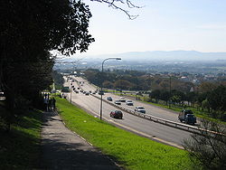
Limited-access road
A limited-access road known by various terms worldwide, including limited-access highway, dual-carriageway and expressway, is a highway or arterial road for high-speed traffic which has many or most characteristics of a controlled-access highway , including limited or no access to adjacent...
in Cape Town
Cape Town
Cape Town is the second-most populous city in South Africa, and the provincial capital and primate city of the Western Cape. As the seat of the National Parliament, it is also the legislative capital of the country. It forms part of the City of Cape Town metropolitan municipality...
, South Africa
South Africa
The Republic of South Africa is a country in southern Africa. Located at the southern tip of Africa, it is divided into nine provinces, with of coastline on the Atlantic and Indian oceans...
, connecting the upper part of the City Bowl
City Bowl
The City Bowl is a part of Cape Town in South Africa. It is a natural amphitheatre-shaped area bordered by Table Bay and defined by the mountains of Signal Hill, Lion's Head, Table Mountain and Devil's Peak....
to the Southern Suburbs
Southern Suburbs, Cape Town
The Southern Suburbs are a group of suburbs in Cape Town, Western Cape, South Africa. This group includes Rondebosch, Claremont, Plumstead, Ottery, Wynberg, Newlands, Constantia and Bishopscourt, and to some aspects Pinelands and Observatory too....
and ending in Tokai
Tokai, Cape Town
Tokai, a large residential suburb of Cape Town, South Africa, is situated on the foothills of the Constantiaberg, and is bordered by, Steenberg and Kirstenhof to the South, Bergvliet to the East, Constantia to the North and the SAFCOL pine tree plantations against the mountain to the...
. For most of its route it parallels - though further to the south and west - the M4 (Main Road), which was the original road connecting central Cape Town with the settlements to the south.
Route
The M3 begins at a traffic light on Buitengracht Street (the M62) and runs south-east as Buitensingel Street, a dual-carriage roadway. For the next three kilometres it runs south and then east through GardensGardens, Cape Town
Gardens is an inner-city suburb of Cape Town located just to the south of the city centre located in the higher elevations of the "City Bowl". It is located directly beneath Table Mountain and Lion's Head. It is an affluent neighbourhood populated mostly by young professionals and contains...
; it changes names regularly, being named Orange Street, Annandale Road, Mill Street and Jutland Avenue. At Roeland Street, which is numbered as Exit 1, the M3 becomes a grade separated dual carriageway and takes on the name De Waal Drive. From there it runs eastwards across the north face of Devil's Peak
Devil's Peak (Cape Town)
Devil's Peak is part of the mountainous backdrop to Cape Town. When looking at Table Mountain from the Victoria & Alfred Waterfront, or when looking at the standard picture postcard view of the mountain, the skyline is from left to right: the spire of Devil's Peak, the flat mesa of Table Mountain,...
to Hospital Bend
Hospital Bend
Hospital Bend is a major freeway junction, located to the east of the central business district of Cape Town, South Africa. It is the junction between the N2 national route and the M3 metropolitan expressway. Its unusual design led to notoriety as a traffic bottleneck and a frequent accident...
, located immediately next to Groote Schuur Hospital
Groote Schuur Hospital
Groote Schuur Hospital is a large, government-funded, teaching hospital situated on the slopes of Devil's Peak in the city of Cape Town, South Africa...
, where it intersects with the N2 Eastern Boulevard.
Around Hospital Bend the M3 is concurrent
Concurrency (road)
A concurrency, overlap, or coincidence in a road network is an instance of one physical road bearing two or more different highway, motorway, or other route numbers...
with the N2
N2 (South Africa)
The N2 is a National Route in South Africa; it is the main highway along the Indian Ocean coast of the country. The N2 starts in Cape Town in the Western Cape and runs through the cities of Port Elizabeth and East London in the Eastern Cape and Durban in KwaZulu-Natal to end at Ermelo in...
for approximately a kilometre; when the N2 branches off to the east as Settlers Way, the M3 runs south as Rhodes Drive past the University of Cape Town
University of Cape Town
The University of Cape Town is a public research university located in Cape Town in the Western Cape province of South Africa. UCT was founded in 1829 as the South African College, and is the oldest university in South Africa and the second oldest extant university in Africa.-History:The roots of...
. This section of the highway forms the western boundary of the suburbs of Mowbray
Mowbray, Cape Town
Mowbray is one of the Southern Suburbs of Cape Town, South Africa. Its original name was Driekoppen .-Geography:Mowbray is bounded on the west by the M3 freeway, beyond which lies Devil's Peak, and on the north by the N2 freeway, beyond which lies the suburb of Observatory...
, Rosebank
Rosebank, Cape Town
Rosebank is one of the Southern Suburbs of Cape Town, South Africa, located between the suburbs of Mowbray and Rondebosch.-Geography:Rosebank is located on the lower eastern slope of Devil's Peak, stretching down to the Liesbeeck River, and on the other side of the river up to the edge of...
, Rondebosch, and part of Newlands
Newlands, Cape Town
Newlands is an upmarket suburb of Cape Town, South Africa.It is located at the foot of Table Mountain in the Southern Suburbs of Cape Town, and is the wettest suburb in South Africa due to its high winter rainfall...
. It separates these suburbs from the Table Mountain National Park
Table Mountain National Park
Table Mountain National Park, previously known as the Cape Peninsula National Park, is a national park in Cape Town, South Africa, proclaimed on May 29, 1998, for the purpose of protecting the natural environment of the Table Mountain Chain, and in particular the rare fynbos vegetation...
, except where the Upper Campus of the University is located west of the freeway.
In Newlands
Newlands, Cape Town
Newlands is an upmarket suburb of Cape Town, South Africa.It is located at the foot of Table Mountain in the Southern Suburbs of Cape Town, and is the wettest suburb in South Africa due to its high winter rainfall...
, the M3 turns away from Table Mountain
Table Mountain
Table Mountain is a flat-topped mountain forming a prominent landmark overlooking the city of Cape Town in South Africa, and is featured in the flag of Cape Town and other local government insignia. It is a significant tourist attraction, with many visitors using the cableway or hiking to the top...
and loses its freeway status; there are 5 traffic lights along this section. In this area it is named variously Union Avenue, Paradise Road and Edinburgh Drive. Over Wynberg Hill, it regains freeway status, and is the first time one encounters the road sign indicating the M3 as a freeway. This section is known officially as the Simon van der Stel Freeway and colloquially as the Blue Route. It proceeds southward through Constantia
Constantia, Cape Town
Constantia is an affluent suburb of Cape Town, South Africa, situated about 15 kilometres south of the centre of Cape Town. The Constantia Valley lies to the east of and at the foot of the Constantiaberg mountain. Constantia Nek is a low pass linking to Hout Bay in the west.-History:Constantia is...
and Tokai
Tokai, Cape Town
Tokai, a large residential suburb of Cape Town, South Africa, is situated on the foothills of the Constantiaberg, and is bordered by, Steenberg and Kirstenhof to the South, Bergvliet to the East, Constantia to the North and the SAFCOL pine tree plantations against the mountain to the...
, terminating at exit 23, an intersection with Steenberg Road (the M42). Steenberg Road connects the terminus of the M3 with the M4 (Main Road) which continues south to Muizenberg
Muizenberg
Muizenberg is a beach-side suburb of Cape Town, South Africa. It is situated where the shore of the Cape Peninsula curves round to the east on the False Bay coast...
, Fish Hoek, and Simon's Town
Simon's Town
Simon's Town , sometimes spelled Simonstown; is a town in South Africa, near Cape Town which is home to the South African Navy. It is located on the shores of False Bay, on the eastern side of the Cape Peninsula. For more than two centuries it has been an important naval base and harbour...
, on the False Bay
False Bay
False Bay is a body of water defined by Cape Hangklip and the Cape Peninsula in the extreme South-West of South Africa.- Description and location :...
coast.
Original plans were for the M3 to continue southwards as a freeway, as can be seen by the unfinished strips of tar under the bridge.
The M3 passes through the following suburbs:
- Cape TownCape TownCape Town is the second-most populous city in South Africa, and the provincial capital and primate city of the Western Cape. As the seat of the National Parliament, it is also the legislative capital of the country. It forms part of the City of Cape Town metropolitan municipality...
CBDCentral business districtA central business district is the commercial and often geographic heart of a city. In North America this part of a city is commonly referred to as "downtown" or "city center"... - GardensGardens, Cape TownGardens is an inner-city suburb of Cape Town located just to the south of the city centre located in the higher elevations of the "City Bowl". It is located directly beneath Table Mountain and Lion's Head. It is an affluent neighbourhood populated mostly by young professionals and contains...
- Vredehoek
- Zonnebloem
- Woodstock
- ObservatoryObservatory, Cape TownObservatory is a suburb in Cape Town, South Africa, bordered by Mowbray to the south, and Salt River to the north. The area is best known as student neighborhood, most of whom attend the University of Cape Town located close by, and for being the home of the South African Astronomical Observatory...
- MowbrayMowbray, Cape TownMowbray is one of the Southern Suburbs of Cape Town, South Africa. Its original name was Driekoppen .-Geography:Mowbray is bounded on the west by the M3 freeway, beyond which lies Devil's Peak, and on the north by the N2 freeway, beyond which lies the suburb of Observatory...
- RosebankRosebank, Cape TownRosebank is one of the Southern Suburbs of Cape Town, South Africa, located between the suburbs of Mowbray and Rondebosch.-Geography:Rosebank is located on the lower eastern slope of Devil's Peak, stretching down to the Liesbeeck River, and on the other side of the river up to the edge of...
- RondeboschRondeboschRondebosch is one of the Southern Suburbs of Cape Town, South Africa. It is primarily a residential suburb, with a medium-size shopping area, a small business district as well as the main campus of the University of Cape Town.-History:...
- NewlandsNewlands, Cape TownNewlands is an upmarket suburb of Cape Town, South Africa.It is located at the foot of Table Mountain in the Southern Suburbs of Cape Town, and is the wettest suburb in South Africa due to its high winter rainfall...
- ClaremontClaremont, Cape TownClaremont is a suburb of Cape Town, South Africa. It is situated six miles south of the city, and is one of the so-called "Southern Suburbs". It is an important commercial and residential area, which is currently experiencing significant growth and development.-History:Until the arrival of Dutch...
- BishopscourtBishopscourt, Cape TownBishopscourt is a small, wealthy, residential suburb in the Southern Suburbs of Cape Town in the Western Cape, South Africa. It is part of the Cape Town Metropolitan Municipality, created in 2000, which includes the greater Cape Town area. It has approximately 350 houses most of which reside on...
- WynbergWynberg, Cape TownWynberg is a southern suburb of the City of Cape Town in Western Cape, South Africa. It is situated between Plumstead and Kenilworth, and is a main transport hub for the Southern Suburbs of Cape Town.- Geography :...
- ConstantiaConstantia, Cape TownConstantia is an affluent suburb of Cape Town, South Africa, situated about 15 kilometres south of the centre of Cape Town. The Constantia Valley lies to the east of and at the foot of the Constantiaberg mountain. Constantia Nek is a low pass linking to Hout Bay in the west.-History:Constantia is...
- Meadowridge
- BergvlietBergvlietBergvliet is a suburb of Cape Town, South Africa. Bergvliet, which means " Mountain Streamlet " in Afrikaans, is bordered by Retreat, Meadowridge, Kreupelbosch, Tokai, and Heathfield....
- TokaiTokai, Cape TownTokai, a large residential suburb of Cape Town, South Africa, is situated on the foothills of the Constantiaberg, and is bordered by, Steenberg and Kirstenhof to the South, Bergvliet to the East, Constantia to the North and the SAFCOL pine tree plantations against the mountain to the...
- Kirstenhof