

M275 motorway
Encyclopedia
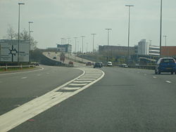
The M275 is a 2 miles (3.2 km) long, dual three-lane motorway in the county of Hampshire
, southern England
. It is the principal route for entering and leaving Portsmouth
. It continues as the A3
into Portsmouth, and meets the M27
at its northern terminus. From the motorway, there are scenic views over Portsmouth harbour, and the Sails of the South
between the two carriageways.
The M275 is one of few motorways in England not being the responsibility of the Highways Agency
. It is managed by Portsmouth City Council from the point where the slip roads to the M27 end. The M275 was not built with a full hard shoulder. For its entire length, a narrow verge is maintained, although there is space available for a full width shoulder. Instead, drivers are warned on entry from the A3 and M27 of the lack of hard shoulder, with signs saying "no hard shoulder for 2 miles".
 The motorway was opened throughout its entire length in 1976. A junction was originally planned for a new development in the Tipner
area of Portsmouth
, known as the Gateway Project, which was shelved at the time. However, the junction's construction was abandoned primarily because planners realised that it would breach regulations that there must be a minimum of 1.25 miles (2 km) between motorway junctions. Before construction was halted, significant work had been carried out, including four incomplete slip roads with no road surfacing, two bridges above the site for the main roundabout
, and realignment of Tipner Lane so that it served the roundabout. In 2001 the Sails of the South
was unveiled close to the site of the missing junction.
In 2005 Portsmouth City Council carried out a refurbishment of the road signs at the M27 junction. New signs were stuck over the old ones but were smaller, including unusual lane illustrations, disproportionate text, lack of route information, increased difficulty to read at a long distance and used incorrect fonts on them, annoying road users and road enthusiasts.
being Junction 1/12 (M275 Junction 1, M27 Junction 12). Most of the road signs have been replaced and the M27/M275 interchange has been remodelled to make it easier for drivers, including splitting one lane into two, although this has meant that some of the overhead gantry signs are now redundant. Portsmouth City Council, the body responsible for the M275, intends completion of the junction by 2009. The junction is now proposed for a link to a large park and ride site proposed underneath the junction.
Information above gathered from Advanced Direction Signs April 2011
Hampshire
Hampshire is a county on the southern coast of England in the United Kingdom. The county town of Hampshire is Winchester, a historic cathedral city that was once the capital of England. Hampshire is notable for housing the original birthplaces of the Royal Navy, British Army, and Royal Air Force...
, southern England
England
England is a country that is part of the United Kingdom. It shares land borders with Scotland to the north and Wales to the west; the Irish Sea is to the north west, the Celtic Sea to the south west, with the North Sea to the east and the English Channel to the south separating it from continental...
. It is the principal route for entering and leaving Portsmouth
Portsmouth
Portsmouth is the second largest city in the ceremonial county of Hampshire on the south coast of England. Portsmouth is notable for being the United Kingdom's only island city; it is located mainly on Portsea Island...
. It continues as the A3
A3 road
The A3, known as the Portsmouth Road for much of its length, is a dual carriageway, or expressway, which follows the historic route between London and Portsmouth passing close to Kingston upon Thames, Guildford, Haslemere and Petersfield. For much of its length, it is classified as a trunk road...
into Portsmouth, and meets the M27
M27 motorway
The M27 is a motorway in Hampshire, England. It is long and runs west-east from Cadnam to Portsmouth. It was opened in stages between 1975 and 1983. It is however unfinished as an extension to the east was planned...
at its northern terminus. From the motorway, there are scenic views over Portsmouth harbour, and the Sails of the South
Sails of the South
The Trimast, commonly referred to as the Sails of the South, is a –high structure situated between two carriageways of the M275 motorway just outside Portsmouth, England....
between the two carriageways.
The M275 is one of few motorways in England not being the responsibility of the Highways Agency
Highways Agency
The Highways Agency is an executive agency, part of the Department for Transport in England. It has responsibility for managing the core road network in England...
. It is managed by Portsmouth City Council from the point where the slip roads to the M27 end. The M275 was not built with a full hard shoulder. For its entire length, a narrow verge is maintained, although there is space available for a full width shoulder. Instead, drivers are warned on entry from the A3 and M27 of the lack of hard shoulder, with signs saying "no hard shoulder for 2 miles".
History
Tipner
Tipner is a residential district of Portsmouth, located on the north western corner of Portsea Island in southern England. It includes a housing estate, built during the 1930s, that used to function as married quarters for the Royal Navy, a yachting club, allotments, a primary school, Waterside...
area of Portsmouth
Portsmouth
Portsmouth is the second largest city in the ceremonial county of Hampshire on the south coast of England. Portsmouth is notable for being the United Kingdom's only island city; it is located mainly on Portsea Island...
, known as the Gateway Project, which was shelved at the time. However, the junction's construction was abandoned primarily because planners realised that it would breach regulations that there must be a minimum of 1.25 miles (2 km) between motorway junctions. Before construction was halted, significant work had been carried out, including four incomplete slip roads with no road surfacing, two bridges above the site for the main roundabout
Roundabout
A roundabout is the name for a road junction in which traffic moves in one direction around a central island. The word dates from the early 20th century. Roundabouts are common in many countries around the world...
, and realignment of Tipner Lane so that it served the roundabout. In 2001 the Sails of the South
Sails of the South
The Trimast, commonly referred to as the Sails of the South, is a –high structure situated between two carriageways of the M275 motorway just outside Portsmouth, England....
was unveiled close to the site of the missing junction.
In 2005 Portsmouth City Council carried out a refurbishment of the road signs at the M27 junction. New signs were stuck over the old ones but were smaller, including unusual lane illustrations, disproportionate text, lack of route information, increased difficulty to read at a long distance and used incorrect fonts on them, annoying road users and road enthusiasts.
Future plans
In 2005, the Tipner Gateway Project was resurrected along with plans for a junction. As previously, preparatory works have been carried out for the junction. Due to the regulations regarding junction spacing, the speed limit on the main carriageway of the M275 has been reduced to 60 mph (26.8 m/s), and 50 mph (22.4 m/s) on the slip roads and from the southern end of Mile End Road to the Kingston Crescent Junction. The latter junction is likely to be renamed Junction 3, with the new Tipner Junction becoming Junction 2, and the junction with the M27M27 motorway
The M27 is a motorway in Hampshire, England. It is long and runs west-east from Cadnam to Portsmouth. It was opened in stages between 1975 and 1983. It is however unfinished as an extension to the east was planned...
being Junction 1/12 (M275 Junction 1, M27 Junction 12). Most of the road signs have been replaced and the M27/M275 interchange has been remodelled to make it easier for drivers, including splitting one lane into two, although this has meant that some of the overhead gantry signs are now redundant. Portsmouth City Council, the body responsible for the M275, intends completion of the junction by 2009. The junction is now proposed for a link to a large park and ride site proposed underneath the junction.
Junctions
| M275 Motorway | |||
| Northbound exits | Junction | Southbound exits | Coordinates |
| Fareham Fareham The market town of Fareham lies in the south east of Hampshire, England, between the cities of Southampton and Portsmouth, roughly in the centre of the South Hampshire conurbation.It gives its name to the borough comprising the town and the surrounding area... , Southampton Southampton Southampton is the largest city in the county of Hampshire on the south coast of England, and is situated south-west of London and north-west of Portsmouth. Southampton is a major port and the closest city to the New Forest... , Gosport Gosport Gosport is a town, district and borough situated on the south coast of England, within the county of Hampshire. It has approximately 80,000 permanent residents with a further 5,000-10,000 during the summer months... M27(W) M27 motorway The M27 is a motorway in Hampshire, England. It is long and runs west-east from Cadnam to Portsmouth. It was opened in stages between 1975 and 1983. It is however unfinished as an extension to the east was planned... Chichester Chichester Chichester is a cathedral city in West Sussex, within the historic County of Sussex, South-East England. It has a long history as a settlement; its Roman past and its subsequent importance in Anglo-Saxon times are only its beginnings... , Brighton Brighton Brighton is the major part of the city of Brighton and Hove in East Sussex, England on the south coast of Great Britain... , Havant Havant Havant is a town in south east Hampshire on the South coast of England, between Portsmouth and Chichester. It gives its name to the borough comprising the town and the surrounding area. The town has rapidly grown since the end of the Second World War.It has good railway connections to London,... (A27), London (A3(M) A3 road The A3, known as the Portsmouth Road for much of its length, is a dual carriageway, or expressway, which follows the historic route between London and Portsmouth passing close to Kingston upon Thames, Guildford, Haslemere and Petersfield. For much of its length, it is classified as a trunk road... ) M27(E) M27 motorway The M27 is a motorway in Hampshire, England. It is long and runs west-east from Cadnam to Portsmouth. It was opened in stages between 1975 and 1983. It is however unfinished as an extension to the east was planned... |
Terminus M27 J12 |
Portsmouth (West) Portsmouth Portsmouth is the second largest city in the ceremonial county of Hampshire on the south coast of England. Portsmouth is notable for being the United Kingdom's only island city; it is located mainly on Portsea Island... , Ferries Portsmouth Harbour Portsmouth Harbour is a large natural harbour in Hampshire, England. Geographically it is a ria: formerly it was the valley of a stream flowing from Portsdown into the Solent River. The city of Portsmouth lies to the east on Portsea Island, and Gosport to the west on the mainland... M275 |
50.83757°N 1.08293°W |
| Cosham Cosham Cosham is a northern suburb of Portsmouth lying within the city boundary but off Portsea Island. It is mentioned in the Domesday Book of 1086 along with Drayton and Wymering and Bocheland , Frodington and Copenore on the island.The name is of Saxon origin and means "Cossa's homestead"... , Paulsgrove Paulsgrove Paulsgrove is an area of northern Portsmouth, Hampshire, England. Paulsgrove existed as a small hamlet on the old Portsmouth to Southampton road for many years. During the early twentieth century Paulsgrove Racecourse was built north of the village on the slopes of Portsdown Hill and a halt built... A27 A27 road The A27 is a major road in England. It runs from its junction with the A36 at Whiteparish in the county of Wiltshire. It closely parallels the south coast, where it passes through West Sussex and terminates at Pevensey in East Sussex.Between Portsmouth and Lewes, it is one of the busiest trunk... |
Start of Motorway | ||
| Start of Motorway | Terminus A3 |
Cross Channel Ferries, North End | 50.80957°N 1.08670°W |
| Out-of-City M275, Cross Channel Ferries Hilsea Hilsea Hilsea is a district of the city of Portsmouth in the English county of Hampshire. Hilsea is home to one of Portsmouth's main sports and leisure facilities - the Mountbatten centre. The City of Portsmouth Boys' School is also in Hilsea... , North End, Stamshaw Stamshaw Stamshaw is a residential district of Portsmouth, located on the north western corner of Portsea Island in southern England.Much of it consists of dense rows of 'two up, two down' terraced housing built during the late 19th century and early 20th century for dockyard workers and their families... A3 A3 road The A3, known as the Portsmouth Road for much of its length, is a dual carriageway, or expressway, which follows the historic route between London and Portsmouth passing close to Kingston upon Thames, Guildford, Haslemere and Petersfield. For much of its length, it is classified as a trunk road... (A27 A27 road The A27 is a major road in England. It runs from its junction with the A36 at Whiteparish in the county of Wiltshire. It closely parallels the south coast, where it passes through West Sussex and terminates at Pevensey in East Sussex.Between Portsmouth and Lewes, it is one of the busiest trunk... ) |
Road continues as A3 to Portsmouth (West) Portsmouth Portsmouth is the second largest city in the ceremonial county of Hampshire on the south coast of England. Portsmouth is notable for being the United Kingdom's only island city; it is located mainly on Portsea Island... and Isle of Wight Isle of Wight The Isle of Wight is a county and the largest island of England, located in the English Channel, on average about 2–4 miles off the south coast of the county of Hampshire, separated from the mainland by a strait called the Solent... Ferries |
||
Information above gathered from Advanced Direction Signs April 2011