
Lostine River
Encyclopedia

Wallowa River
The Wallowa River is a tributary of the Grande Ronde River, approximately long, in northeastern Oregon in the United States. It drains a valley on the Columbia Plateau in the northeast corner of the state north of Wallowa Mountains. It rises in southern Wallowa County, in the Wallowa Mountains in...
in northeastern Oregon
Oregon
Oregon is a state in the Pacific Northwest region of the United States. It is located on the Pacific coast, with Washington to the north, California to the south, Nevada on the southeast and Idaho to the east. The Columbia and Snake rivers delineate much of Oregon's northern and eastern...
in the United States.
It drains a portion of the Eagle Cap Wilderness
Eagle Cap Wilderness
Eagle Cap Wilderness is a wilderness area located in the Wallowa Mountains of northeastern Oregon , within the Wallowa–Whitman National Forest. The Wilderness was established in 1940. In 1964, it was included in the National Wilderness Preservation System...
of the Wallowa Mountains
Wallowa Mountains
The Wallowa Mountains are a mountain range located in the Columbia Plateau of northeastern Oregon in the United States. The range runs approximately 40 mi northwest to southeast in southwestern Wallowa County between the Blue Mountains to the west and the Snake River to the east. The range is...
in the Wallowa-Whitman National Forest
Wallowa-Whitman National Forest
The Wallowa–Whitman National Forest is a United States National Forest in Oregon. Formed by a merger of the formerly separate Wallowa and Whitman national forests, it is located in the northeastern corner of the state, in Wallowa, Baker, Union, Grant, and Umatilla counties in Oregon, and includes...
. It joins the Wallowa River at Wallowa
Wallowa, Oregon
Wallowa is a city in Wallowa County, Oregon, United States. The population was 869 at the 2000 census.-History:Wallowa was platted in 1889. Wallowa is a Nez Perce word describing a triangular structure of stakes that in turn supported a network of sticks called lacallas to form a fish trap. The Nez...
. In 1988, 16 miles (25.7 km) of the Lostine received National Wild and Scenic River
National Wild and Scenic River
National Wild and Scenic River is a designation for certain protected areas in the United States.The National Wild and Scenic Rivers Act was an outgrowth of the recommendations of a Presidential commission, the Outdoor Recreation Resources Review Commission...
designation.
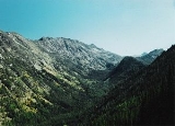
It rises as two forks, the East Fork (sometimes referred to as East Lostine River) and West Fork (shown on topographic maps as the Lostine River main stem) at elevations of more than 8000 feet (2,438.4 m) approximately 15 miles (24.1 km) south of the city of Lostine
Lostine, Oregon
Lostine is a city in Wallowa County, Oregon, United States. The population was 263 at the 2000 census.-Geography:According to the United States Census Bureau, the city has a total area of , all land.-Demographics:...
and 10 miles (16.1 km) west-southwest of Joseph
Joseph, Oregon
Joseph is a city in Wallowa County, Oregon, United States. Originally named Silver Lake and Lake City, in 1880 the city formally named itself for Nez Perce Chief Joseph. The population was 1,054 at the 2000 census.- History :...
. They meet at 45.1854294°N 117.3512976°W. It flows generally northward following a large U-shaped canyon. It exits the national forest at an elevation of 3930 feet (1,197.9 m) and gradually changes character as it reaches more level terrain which slopes gradually down to 3000 feet (914.4 m), where it meets the Wallowa River. The river's flow varies seasonally from about 50 cuft/s.
Irrigation diversions play a significant role in the river, both as input from the Minam Lake and Minam River
Minam River
The Minam River is a tributary of the Wallowa River, long, in northeastern Oregon in the United States. It drains a rugged wilderness area of the Wallowa Mountains west of La Grande....
and diversionary output to the Wallowa River
Wallowa River
The Wallowa River is a tributary of the Grande Ronde River, approximately long, in northeastern Oregon in the United States. It drains a valley on the Columbia Plateau in the northeast corner of the state north of Wallowa Mountains. It rises in southern Wallowa County, in the Wallowa Mountains in...
. These water diversions contributed to the end of the local run of coho salmon
Coho salmon
The Coho salmon, Oncorhynchus kisutch, is a species of anadromous fish in the salmon family. Coho salmon are also known as silver salmon or "silvers". It is the state animal of Chiba, Japan.-Description:...
, and reduced the population of the run of spring chinook salmon
Chinook salmon
The Chinook salmon, Oncorhynchus tshawytscha, is the largest species in the pacific salmon family. Other commonly used names for the species include King salmon, Quinnat salmon, Spring salmon and Tyee salmon...
to a low of 13 fish in 1999; both had been a historic source of food for the Nez Perce people. Since that year the chinook salmon run has recovered to 800 fish in 2005. An agreement between the farmers, the Nez Perce and the Oregon Water Trust
Oregon Water Trust
The Oregon Water Trust is an environmental organization based in the U.S. state of Oregon. Its mission is to restore surface water flows for healthier streams in Oregon by using cooperative, free-market solutions...
reached in 2005 have led to an effort to preserve the streamflow during the summer, helping the salmon run to survive. Since that year the chinook salmon population has increased to 3,000 fish in 2009.