
.gif)
Lordship Lane (Haringey)
Encyclopedia
Lordship Lane connects Wood Green
(N22) with Tottenham High Road
(N17). It lies in the London Borough of Haringey
and forms part of the A109 road.
. There were a number of these clearings in the vicinity and each is likely to have been the site of a few simple habitations. Lordship Lane would have begun as a track running through the forest from the clearing at Wood Green to Ermine Street
, the main Roman road
from London
to the north east.
During the 1000 years before the Norman Conquest, the county of Middlesex
was established and divided into administrative areas called Hundreds. Lordship Lane was in Edmonton Hundred
. The importance of the Hundred in local government declined as that of the Manor
grew. Manors were estates controlled by a landowner called the Lord of the Manor
. Tottenham’s manor house is on Lordship Lane. It is called Bruce Castle
.
By 1619 (the date of the first known map) the land to the north and south of Lordship Lane had been cleared of woodland and was mostly in cultivation. On this map the majority of the lane (from Chapmans Green to Tottenham High Road
) is called Berry Lane although its modern name was recorded in 1526. In 1904 tram tracks were laid to connect Wood Green with Tottenham
. These followed Lordship Lane as far as Bruce Castle. Between 1936 and 1939 the tram was replaced by trolleybuses. In 1961 these were in turn replaced by diesel buses.

is at the western end of Lordship Lane. It is served by the Piccadilly Line
.
report revealed that in 2004/5, Haringey Council collected £3.2m in fines for traffic offences occurring in the street, a figure greater than any other street in the country.

Wood Green
Wood Green is a district in north London, England, located in the London Borough of Haringey. It is situated north of Charing Cross. The area is identified in the London Plan as one of the metropolitan centres in Greater London.-History:...
(N22) with Tottenham High Road
Tottenham High Road
Tottenham High Road is the main thoroughfare through the district of Tottenham, in the London Borough of Haringey. It runs from Edmonton in the North to Stamford Hill in the South . It follows, for the whole of its length, the course of the erstwhile Roman Road, Ermine Street...
(N17). It lies in the London Borough of Haringey
London Borough of Haringey
The London Borough of Haringey is a London borough, in North London, classified by some definitions as part of Inner London, and by others as part of Outer London. It was created in 1965 by the amalgamation of three former boroughs. It shares borders with six other London boroughs...
and forms part of the A109 road.
History
Wood Green was originally a clearing in the dense forests of oak, ash and beech that covered most of what is now North LondonNorth London
North London is the northern part of London, England. It is an imprecise description and the area it covers is defined differently for a range of purposes. Common to these definitions is that it includes districts located north of the River Thames and is used in comparison with South...
. There were a number of these clearings in the vicinity and each is likely to have been the site of a few simple habitations. Lordship Lane would have begun as a track running through the forest from the clearing at Wood Green to Ermine Street
Ermine Street
Ermine Street is the name of a major Roman road in England that ran from London to Lincoln and York . The Old English name was 'Earninga Straete' , named after a tribe called the Earningas, who inhabited a district later known as Armingford Hundred, around Arrington, Cambridgeshire and Royston,...
, the main Roman road
Roman road
The Roman roads were a vital part of the development of the Roman state, from about 500 BC through the expansion during the Roman Republic and the Roman Empire. Roman roads enabled the Romans to move armies and trade goods and to communicate. The Roman road system spanned more than 400,000 km...
from London
London
London is the capital city of :England and the :United Kingdom, the largest metropolitan area in the United Kingdom, and the largest urban zone in the European Union by most measures. Located on the River Thames, London has been a major settlement for two millennia, its history going back to its...
to the north east.
During the 1000 years before the Norman Conquest, the county of Middlesex
Middlesex
Middlesex is one of the historic counties of England and the second smallest by area. The low-lying county contained the wealthy and politically independent City of London on its southern boundary and was dominated by it from a very early time...
was established and divided into administrative areas called Hundreds. Lordship Lane was in Edmonton Hundred
Edmonton (hundred)
Edmonton was an ancient hundred in the north of the county of Middlesex, England. Its former area has been mostly absorbed by the growth of London and it now corresponds to the London Borough of Enfield and parts of the London Borough of Barnet and London Borough of Haringey in Greater London and...
. The importance of the Hundred in local government declined as that of the Manor
Manorialism
Manorialism, an essential element of feudal society, was the organizing principle of rural economy that originated in the villa system of the Late Roman Empire, was widely practiced in medieval western and parts of central Europe, and was slowly replaced by the advent of a money-based market...
grew. Manors were estates controlled by a landowner called the Lord of the Manor
Lord of the Manor
The Lordship of a Manor is recognised today in England and Wales as a form of property and one of three elements of a manor that may exist separately or be combined and may be held in moieties...
. Tottenham’s manor house is on Lordship Lane. It is called Bruce Castle
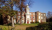
Bruce Castle
Bruce Castle is a Grade I listed 16th-century manor house in Lordship Lane, Tottenham, London. It is named after the House of Bruce who formerly owned the land on which it is built. Believed to stand on the site of an earlier building, about which little is known, the current house is one of the...
.
By 1619 (the date of the first known map) the land to the north and south of Lordship Lane had been cleared of woodland and was mostly in cultivation. On this map the majority of the lane (from Chapmans Green to Tottenham High Road
Tottenham High Road
Tottenham High Road is the main thoroughfare through the district of Tottenham, in the London Borough of Haringey. It runs from Edmonton in the North to Stamford Hill in the South . It follows, for the whole of its length, the course of the erstwhile Roman Road, Ermine Street...
) is called Berry Lane although its modern name was recorded in 1526. In 1904 tram tracks were laid to connect Wood Green with Tottenham
Tottenham
Tottenham is an area of the London Borough of Haringey, England, situated north north east of Charing Cross.-Toponymy:Tottenham is believed to have been named after Tota, a farmer, whose hamlet was mentioned in the Domesday Book; hence Tota's hamlet became Tottenham...
. These followed Lordship Lane as far as Bruce Castle. Between 1936 and 1939 the tram was replaced by trolleybuses. In 1961 these were in turn replaced by diesel buses.
Wood Green High Road (A105) to Perth Road
- Junction with A105A105 roadThe A105 road is an A road in London, England. It runs from Canonbury, in between Highbury and Dalston, to Enfield Town. The road is long. Part of the road forms Green Lanes, one of the longest streets in London, while the A105 also serves as the primary access route to the Shopping City shopping...
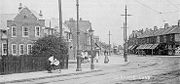
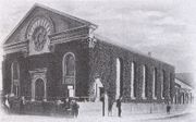
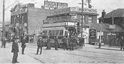
Wood Green High Road: The parade of shops shown in the old photograph turns the corner from Wood Green High Road on the left into Lordship Lane on the right. The leftmost of these (up to the bank) were demolished in 1931 to make way for Wood Green tube station. The bank remains but has a more imposing façade and is now a branch of Barclays. The trees are on what was then a small green and is now a concrete plaza called Spouters Corner.
- Wood Green Crown CourtCrown CourtThe Crown Court of England and Wales is, together with the High Court of Justice and the Court of Appeal, one of the constituent parts of the Senior Courts of England and Wales...
: In 1857 the Royal Masonic School for BoysRoyal Masonic School for BoysThe Royal Masonic School for Boys was an independent school for boys in England.From 1798 charities were set up for clothing and educating sons of needy Freemasons. They originally provided education by sending them to schools near to their homes...
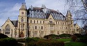
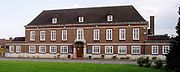
, for the sons of deceased and needy Freemasons, was founded on this site in the former Lordship Lodge on an estate of 10 acres (40,468.6 m²). Originally catering for 70 boys, the old house was replaced in 1865 by a substantial Gothic building with accommodation for 200. In 1898 the site was sold to the Home and Colonial School Society, which opened a Training College for Schoolmistresses in 1904. This ran until 1930 when the site was sold to the Tottenham District Gas Company, and the building renamed Woodall House after its chairman, Sir Colbert Woodall. It later became the offices of Eastern Gas until 1974 when the site was acquired by Haringey Council. The building was modernised and became the Wood Green Crown Court and Remand Centre with the rest of the site developed for housing. The building was struck by arson in c1989 and promptly rebuilt with a new and very assertive roof.
- The Lordship Pub: Formerly the Rat & Carrot. Originally His Lordship's Tavern opened by 1875.
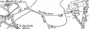
Perth Road to The Roundway (A1080)
- Chapmans Green: A very small park in traditional style with bowls and tennis. It holds a Green Flag AwardGreen Flag AwardThe Green Flag Award is the benchmark national standard for parks and green spaces in the United Kingdom. The scheme was set up in 1996 to recognise and reward green spaces in England and Wales that met the laid down high standards...
. - Two buildings, Pickering Court and an unnamed court occupy the site of a co-opThe Co-operative GroupThe Co-operative Group Ltd. is a United Kingdom consumer cooperative with a diverse range of business interests. It is co-operatively run and owned by its members. It is the largest organisation of this type in the world, with over 5.5 million members, who all have a say in how the business is...
grocery store that was destroyed by the only significant bomb strike to Lordship Lane during World War IIWorld War IIWorld War II, or the Second World War , was a global conflict lasting from 1939 to 1945, involving most of the world's nations—including all of the great powers—eventually forming two opposing military alliances: the Allies and the Axis...
. - Two pairs of semi-detached houses: Numbers 578 to 584. The 1950s style house grafted onto the end of a Victorian terrace is a consequence of the only significant bomb strike to Lordship Lane during World War IIWorld War IIWorld War II, or the Second World War , was a global conflict lasting from 1939 to 1945, involving most of the world's nations—including all of the great powers—eventually forming two opposing military alliances: the Allies and the Axis...
. - Lordship Lane Junior SchoolLordship Lane Junior SchoolLordship Lane Junior School is a primary school in Wood Green, Haringey, London, United Kingdom.-History:Lordship Lane Elementary Board School opened in 1905, with an adjoining infants school situated in Granville Road. The Elementary Board school comprised junior and boys' secondary schools...
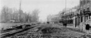
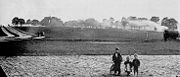
: Built in 1905 on land formerly belonging to Graingers farm. Opened in 1906 when a temporary school in Gladstone Avenue (opened 1889) transferred here. In the old photograph Ellenborough Road is on the left, Boreham Road is on the right and the Junior School is on the left. The tram is at the point where the Roundway and Downhills Way were laid out in the 1920s. - A1080 The Roundway: A major radial road into London which here reduces from a dual carriageway to a two way road. It was laid out in the 1930s and marks the boundary between N22 and N17N postcode areaThe N postcode area, also known as the London N postcode area, is the part of the London post town covering part of North London, England....
.
The Roundway (A1080) to The Roundway (A10)
- Edge of Tower Gardens estateTower Gardens EstateTower Gardens in North Tottenham is a distinctive semi-circular estate bounded by Lordship Lane and the Roundway. Constructed between 1904 and 1928, it was one of the first municipal "cottage estates" in the world. It is now a conservation area and recently featured in Open House London...
: Numbers 388 to 458. At the beginning of the twentieth century London County CouncilLondon County CouncilLondon County Council was the principal local government body for the County of London, throughout its 1889–1965 existence, and the first London-wide general municipal authority to be directly elected. It covered the area today known as Inner London and was replaced by the Greater London Council...
acquired 179 acre (0.72438794 km²) of fields to the north of the lane and by 1910 48 acre (0.19424928 km²) had been laid out on 'garden suburb' principles. The estate is now a conservation areaConservation areaA conservation areas is a tract of land that has been awarded protected status in order to ensure that natural features, cultural heritage or biota are safeguarded...
. - Edge of the Peabody Tottenham estate: Numbers 80 to 86, entrance, 88 to 124, entrance, 126 to 130. One hundred and fifty four terraced cottages were built in 1907 by the Peabody TrustPeabody TrustPeabody Trust , founded in 1862, is one of London's oldest and largest housing associations with over 19,000 properties. It also a charity and urban regeneration agency...
, a philanthropic Model Dwellings CompanyModel dwellings companyModel Dwellings Companies were a group of private companies in Victorian Britain that sought to improve the housing conditions of the working classes by building new homes for them, at the same time receiving a competitive rate of return on any investment...
funded by a trust set up by George PeabodyGeorge PeabodyGeorge Peabody was an American-British entrepreneur and philanthropist who founded the Peabody Trust in Britain and the Peabody Institute in Baltimore, and was responsible for many other charitable initiatives.-Biography:...
to build housing for the needy working classWorking classWorking class is a term used in the social sciences and in ordinary conversation to describe those employed in lower tier jobs , often extending to those in unemployment or otherwise possessing below-average incomes...
. In 2006 the estate buildings facing Lordship Lane were auctioned off for refurbishment by private individuals. - A10, the Roundway.
The Roundway (A10) to Tottenham High Road (A1010)
- Church Lane: Leads to All HallowsAll Hallows, TottenhamAll Hallows is an Anglican church in Tottenham, North London. It is one of the oldest buildings in the London Borough of Haringey, being built as All Saints Church in the 12th century. It was re-dedicated as All Hallows in the 15th century, standing adjacent to Bruce Castle and Tottenham Cemetery...
(Tottenham’s Parish Church) and Tottenham cemetery. The church is reputed to have been bestowed to Tottenham by David I of ScotlandDavid I of ScotlandDavid I or Dabíd mac Maíl Choluim was a 12th-century ruler who was Prince of the Cumbrians and later King of the Scots...
in 1134. Its tower is 14th century, and much of the rest is original. - Bruce CastleBruce CastleBruce Castle is a Grade I listed 16th-century manor house in Lordship Lane, Tottenham, London. It is named after the House of Bruce who formerly owned the land on which it is built. Believed to stand on the site of an earlier building, about which little is known, the current house is one of the...
: At the time of the Domesday Book (1086) the Lord of the Manor was Waltheof, son of Gospatric, Earl of Northumberland. Both father and son are commemorated in the names of streets in the Tower Gardens Estate, while the Earldom is commemorated in the name of an adjoining area called Northumberland ParkNorthumberland ParkNorthumberland Park may refer to:* Northumberland Park, London* Northumberland Park railway station, a London Underground station in Northumberland Park, London* Northumberland Park Depot, a London Underground depot in Northumberland Park, London...
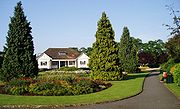
. Bruce Castle is now the Haringey Museum of Local History including an Archive and Library. The grounds form a park with a Green Flag AwardGreen Flag AwardThe Green Flag Award is the benchmark national standard for parks and green spaces in the United Kingdom. The scheme was set up in 1996 to recognise and reward green spaces in England and Wales that met the laid down high standards...
. - Railway Bridge: Formerly carried the Great Eastern RailwayGreat Eastern RailwayThe Great Eastern Railway was a pre-grouping British railway company, whose main line linked London Liverpool Street to Norwich and which had other lines through East Anglia...
line from Liverpool Street StationLiverpool Street stationLiverpool Street railway station, also known as London Liverpool Street or simply Liverpool Street, is both a central London railway terminus and a connected London Underground station in the north-eastern corner of the City of London, England...
to EnfieldEnfield TownEnfield Town is the historic town centre of Enfield, formerly in the county of Middlesex and now in the London Borough of Enfield. It is north north-east of Charing Cross...
, now operated by Network RailNetwork RailNetwork Rail is the government-created owner and operator of most of the rail infrastructure in Great Britain .; it is not responsible for railway infrastructure in Northern Ireland...
. - Terrace: Numbers 8 to 18. Dated 1826. "Bruce Terrace, a modest yellow-brick row, stands neglected by the railway line in Lordship Lane; it was built by an early 19th-century iron-founder, Thomas Finney, and some of the houses retain iron steps which were laid at the gate-ways instead of stone slabs."
- Junction with A1010A1010 roadThe A1010 is a road running through north London from Bruce Grove in Tottenham to Waltham Cross. It also used to continued north through Cheshunt to Turnford....
Tottenham High RoadTottenham High RoadTottenham High Road is the main thoroughfare through the district of Tottenham, in the London Borough of Haringey. It runs from Edmonton in the North to Stamford Hill in the South . It follows, for the whole of its length, the course of the erstwhile Roman Road, Ermine Street...
.
Tottenham High Road (A1010) to Bruce Grove (A10)
- Millicent Fawcett Court: A small, award-winning deck access council estate, built 1969-70 comprising three blocks arranged as an elongated "u", the long axis running north-south, about four stories high. None of the flats has a Lordship Lane address. Numbers 1 to 19 were (presumably) demolished to make way for it. Named after Millicent FawcettMillicent FawcettDame Millicent Garrett Fawcett, GBE was an English suffragist and an early feminist....
, suffragist and early feminist. The eastern part of the estate is built over the Moselle RiverRiver Moselle (London)The River Moselle, also referred to as Moselle Brook, is in North London and flows through Tottenham towards the Lea Valley. The river was originally a tributary of the River Lea, but it now flows into Pymmes Brook, another Lea tributary....
, which was re-culverted during construction of the estate. There have been buildings on this site since at least 1619[ M02] . - Enfield Magistrates Court:The Probation Service is housed in a modern building on the same site at number 71.
- Bruce Castle Court: A fifties-style apartment block with 1950s metal framed windows. In 1619 this site was called Slaughter House Yard
[ M02] . - A10 Bruce GroveBruce GroveBruce Grove is a ward in Tottenham, enclosed by Lordship Recreation Ground, Lordship Lane, Philip Lane, and the High Road.The Bruce Grove area of the Tottenham High Road has received a £1m grant from the Heritage Lottery Fund to restore the historic Victorian and Edwardian buildings to their...
Bruce Grove (A10) to Lordship Recreation Ground
- The Elmhurst Hotel: Built 1903.
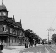
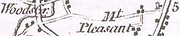
- Mount Pleasant RoadMount Pleasant RoadMount Pleasant Road is a major arterial thoroughfare in the Canadian city of Toronto, Ontario that travels from Jarvis Street south of Bloor Street north to Glen Echo Drive. The road is unique as one of the few arterial roads in Toronto to be created after the development of the suburbs which it...
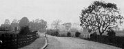
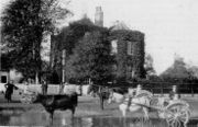
The old photograph shows preparations to lay the Metropolitan Electric Tramway Company’s route from Wood Green to Bruce Grove, opened in 1904. The turning on the right is Mount Pleasant Road. In the far distance the Elmhurst Public House is on the right and Bruce castle is on the left. The fields on the left were used in 1907 for the Peabody Estate. - Lido Estate: Laid out on the site of the former Lordship Lane Lido. The Lido was opened on 5 June 1937 by Mayor J. H. Morrell and officially called "The Tottenham Lido". It cost £30,000. It replaced the "Old Marshes Bath" after a long process begun in 1930 and delayed by the 1931 financial crisis and difficulty in getting Ministry of Health approval. It was a very popular summer attraction for many years. Attendance fell during a run of poor summers in the late 1970s and early 80's. It was finally closed in 1985 as a cost cutting measure by Haringey council. See Lidos in London no longer open, Tottenham Lido. Numbers 241A/B 243A/B 245A.
Lordship Recreation Ground to Downhills Way (B155)
- Public Toilets: This is (believed to be) a listed building.
- Lordship Recreation Ground: Opened in 1932 on about 100 acre (0.404686 km²) of the former Broadwater FarmBroadwater FarmBroadwater Farm, often referred to simply as "The Farm", is an area in Tottenham, North London, straddling the River Moselle. The eastern half of the area is dominated by the Broadwater Farm Estate , an experiment in high-density social housing built in the late 1960s...
acquired by Tottenham Urban District Council. In the intervening years it has shrunk somewhat as the edges have been nibbled at for development, especially for the infamous Broadwater Farm estate built in the early 1970s. The river MoselleRiver Moselle (London)The River Moselle, also referred to as Moselle Brook, is in North London and flows through Tottenham towards the Lea Valley. The river was originally a tributary of the River Lea, but it now flows into Pymmes Brook, another Lea tributary....
runs through the centre of the park.
Moselle Avenue to Wood Green High Road (A105)
- Mecca BingoThe Rank GroupThe Rank Group plc is a European gaming and leisure business. It is listed on the London Stock Exchange and is a constituent of the FTSE 250 Index.-History:...
: From the 1920s the site of the former City Bus company depot. After Nationalisation in 1947, the depot and starting point of the Eastern National routes to Southend and Westcliff. The building and forecourt were used for the non-studio scenes in the 1970s British TV series On the BusesOn The BusesOn the Buses was a British situation comedy created by Ronald Wolfe and Ronald Chesney which was broadcast in the UK from 1969 to 1973. The writers' previous successes with The Rag Trade and Meet the Wife were for the BBC, but the Corporation rejected On the Buses, not seeing much comedy potential...
. Services ceased in the early 1980s and the building was redeveloped as a W H SmithW H SmithWHSmith plc is a British retailer, headquartered in Swindon, Wiltshire, England. It is best known for its chain of high street, railway station, airport, hospital and motorway service station shops selling books, stationery, magazines, newspapers, and entertainment products...
'Do-it-all' centre. In the 1990s this was converted into the Bingo Hall. - Hollywood Green Showcase Cinema: For most of the twentieth century the Lordship Lane frontage of this site accommodated the Cinematograph Theatre building and Burridge and Company, undertakers. The Cinematograph was a purpose built cinema. It opened in 1910 and closed in the late 1920s. The building then became Garner's furniture depository and housed Harry Boult's School of Dancing on the first floor. In more recent years it become an indoor market hall. Both buildings were demolished in 1999 to make way for Hollywood Green a six screen cinema. Also visible in the old photograph is H D Chesser, Farrier (or Blacksmith) which survived as a going concern from 1770 to 1920s. There has been a building at the far west of the lane since at least 1619
[ M02] . - Spouters Corner: Was first used for a political meeting in 1867 by the Reform LeagueReform LeagueThe Reform League was established in 1865 to press for manhood suffrage and the ballot in Great Britain. It collaborated with the more moderate and middle class Reform Union and gave strong support to the abortive Reform Bill 1866 and the successful Reform Act 1867...
. By the end of the nineteenth century the common landCommon landCommon land is land owned collectively or by one person, but over which other people have certain traditional rights, such as to allow their livestock to graze upon it, to collect firewood, or to cut turf for fuel...
here had become a venue for stump orators and political gatherings, thereby acquiring its name. Its significance increased during the First World War and the inter-war years. It was also an assembly point for contracting local labour before Labour Exchanges were introduced in 1910. In the post war years it attracted both local and national political figures and saw CND meetings in the late 1950s and 1960s. In more recent years its use has waned as political speakers have favoured the forecourt of the Central Library. But it accommodates a large fir tree each Christmas.
Underground
Wood Green tube stationWood Green tube station
Wood Green is a London Underground station on the Piccadilly Line. The station is between Turnpike Lane and Bounds Green stations and is in Travelcard Zone 3. It is located at junction of Wood Green High Road and Lordship Lane...
is at the western end of Lordship Lane. It is served by the Piccadilly Line
Piccadilly Line
The Piccadilly line is a line of the London Underground, coloured dark blue on the Tube map. It is the fifth busiest line on the Underground network judged by the number of passengers transported per year. It is mainly a deep-level line, running from the north to the west of London via Zone 1, with...
.
Buses
Bus routes 123, 144, 243, 318 and W3 serve the lane:- 123 (Wood Green to Ilford) serves the central section of the lane between Westbury Avenue and Bruce Grove.
- 144 (Muswell Hill to Edmonton Green) serves the western end of the lane between Wood Green tube station to The Roundway (West Arm).
- 243London Buses route 243London Buses route 243 is a Transport for London contracted bus route in London, United Kingdom. The service is currently contracted to Arriva London.-History:...
(Wood Green to Waterloo) runs from its terminus at Wood Green tube station to Bruce Castle where it turns off down Bruce Grove. - 318 (North Middlesex Hospital to Stamford Hill) serves the eastern end of the lane between Tottenham High RoadTottenham High RoadTottenham High Road is the main thoroughfare through the district of Tottenham, in the London Borough of Haringey. It runs from Edmonton in the North to Stamford Hill in the South . It follows, for the whole of its length, the course of the erstwhile Roman Road, Ermine Street...
and The Roundway (East Arm). - W3 (Finsbury Park to Northumberland Park) serves a short stretch of the western end of the lane between Wood Green tube station and Perth Road.
Other
A Channel 4 NewsChannel 4 News
Channel 4 News is the news division of British television broadcaster Channel 4. It is produced by ITN, and has been in operation since the broadcaster's launch in 1982.-Channel 4 News:...
report revealed that in 2004/5, Haringey Council collected £3.2m in fines for traffic offences occurring in the street, a figure greater than any other street in the country.
CCTV
There are cameras (west to east):- At the west end of Lordship Lane, opposite the junction with Wood Green High Road
- Opposite Sprouters Corner
- Opposite Morley Avenue
- Opposite Boreham Road
- At the east end of Lordship Lane, opposite the junction with Tottenham High Road
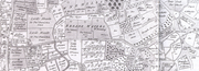
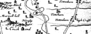
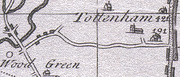
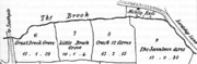
Maps (in chronological order)
- Survey of woods and groves in Edmonton, Tottenham and Enfield in Middlesex for the Dean and Chapter of St. Pauls by Israel Amyce, Surveyor, 1599; Gdl, MS 18798.
- Map of Tottenham 1619 accompanying the Earl of Dorset's survey 6" BCM.
- John OgilbyJohn OgilbyJohn Ogilby was a Scottish translator, impresario and cartographer. Best known for publishing the first British road atlas, he was also a successful translator, noted for publishing his work in handsome illustrated editions.-Life:Ogilby was born in or near Killemeare in November 1600...
’s Map of Middlesex c1677. - Edward Wyburd's Survey and Plan 1718.
- John Warburton Map of the City of London and Middlesex 1749.
- Topographic Map of The County of Middlesex 1754 by John Rocque (Reprinted by LMAS 1971).
- Extract from John Carey Map of Middlesex 1793.
- 1798 Tottenham Plan for Wyburd Survey by Henry Piper Spurling, by Jonathon and William Newton, 1817; BCM.
- Facsimile of the OS's Drawings of the London Area 1799–1808 OSD 152/Serial #104 Hampstead 2" to 1 miles (1.6 km) London Topographical Survey Publication Number 144 (1991).
- Milne's Land use map of Middlesex 1800.
- A New Map of Middlesex by John Cary 1802.
- Extract from a map of Tottenham, 1818. Drawn by Jonathon and William Newton for Robinson's History and Antiques of Tottenham. based on a 1798 survey.
- Survey of Middlesex 1818 - 17 2" to 1 miles (1.6 km).
- Greenwood's map of Middlesex, 1819.
- OS 1822 Sheet 71 London (David and Charles Ed. 1969) was sheet 7 of 1" old series.
- Tithe Commissioner's Map of Tottenham 1844.
- Ducketts Farm Fields Map c1846.
- OS 1864 of Middlesex, Parish of Tottenham 1st edition 25".
- OS 1869-82 1st edition (25 inch).
- OS 1873 1st edition, Middlesex sheet XII.
- OS 1894-96, London sheet 3, Middlesex sheet VII 15 1:2500 (25 inch).
- OS 1894–1937 Sheet III 14, 15, 16, 17, 26 (5 ft) Middlesex.
- 1st edition (5 ft) Middlesex.
- 2nd edition London Sheet III 14, 15, 16, 17, 26 (5 ft).
- 1894-1922 Land Registry Series Sheet III 14, 15, 16, 17, 26 (5 ft).
- OS 1896 (6 inch). May be County Series and three sheets: Essex, London & Middlesex.
- Railways into Wood green circa 1900.
- OS 1912 - 14 (3rd edition) (25 inch).
- OS 1920 (6 inch). May be County Series and three sheets: Essex, London & Middlesex.
- 1934-9 LCC Revised OS Sheet III 14, 15, 16, 17, 26 (5 ft).
- 251935-7 OS Revised (5 ft) Sheet III 14, 15, 16, 17, 26.
- LCC 1940 (25 inch).
- OS 1946 (6 inch). May be County Series and three sheets: Essex, London & Middlesex.
| Abbreviations | |
| BCM | Bruce Castle Museum |
| LCC | London County Council |
| LMAS | London and Midland Archaeological Society, Museum of London. |
| OS | Ordnance Survey |