

Lohagad
Encyclopedia
- For the fort in Rajasthan see Lohagarh FortLohagarh FortLohagarh Fort is situated at Bharatpur in Rajasthan, India. It was constructed by Bharatpur Jat rulers. Maharaja Suraj Mal used all his power and wealth to a good cause, and built numerous forts and palaces across his kingdom, one of them being the Lohagarh Fort , which was one of the strongest...
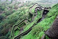

On the west side, there is a long and narrow wall-like fortified spur called Vinchukata (Marathi
Marathi language
Marathi is an Indo-Aryan language spoken by the Marathi people of western and central India. It is the official language of the state of Maharashtra. There are over 68 million fluent speakers worldwide. Marathi has the fourth largest number of native speakers in India and is the fifteenth most...
for Scorpion's tail; see picture) because of its shape. Lohagad has a long history with several dynasties occupying it at different periods of time: Satavahanas, Chalukyas, Rashtrakutas, Yadavas, Bahamanis, Nizamshahis, Mughals and Marathas. Shivaji captured it in 1648 CE, but he was forced to surrender it to the Mughals in 1665 CE by the Treaty of Purandar
Treaty of Purandar
The Treaty of Purandar may be referring to one of the articles below.*Treaty of Purandar - Between Rajput Jai Singh I and Maratha Shivaji Maharaj.*Treaty of Purandar - Between the Peshwa of the Maratha Empire and the British East India Company....
. Shivaji recaptured the fort in 1670 CE and used it for keeping his treasury.
How to reach the fort
From MumbaiMumbai
Mumbai , formerly known as Bombay in English, is the capital of the Indian state of Maharashtra. It is the most populous city in India, and the fourth most populous city in the world, with a total metropolitan area population of approximately 20.5 million...
, you can take a train
Train
A train is a connected series of vehicles for rail transport that move along a track to transport cargo or passengers from one place to another place. The track usually consists of two rails, but might also be a monorail or maglev guideway.Propulsion for the train is provided by a separate...
to Lonavla. Malawli is the next station from Lonavla in the direction toward Pune. There are a number of local trains operating between Lonavla and Pune
Pune
Pune , is the eighth largest metropolis in India, the second largest in the state of Maharashtra after Mumbai, and the largest city in the Western Ghats. Once the centre of power of the Maratha Empire, it is situated 560 metres above sea level on the Deccan plateau at the confluence of the Mula ...
; you can take any of them. From Pune
Pune
Pune , is the eighth largest metropolis in India, the second largest in the state of Maharashtra after Mumbai, and the largest city in the Western Ghats. Once the centre of power of the Maratha Empire, it is situated 560 metres above sea level on the Deccan plateau at the confluence of the Mula ...
, you can take any of these locals.
From Malawli railway station, the fort is just 9 km away. Vehicles can go up to the foot of the hill. From here, which is near a village called Lohagaon, there are steps to the fort, numbering approximately 500.
However, people can also walk all the way till the fort. Bhaja Caves
Bhaja Caves
Bhaja Caves are a group of 22 rock-cut caves dating back to 200 BC located at Karli, near Lonavala, Maharashtra. The location of Bhaja caves is not far from location of Karla Caves and these are stylistically similar to the Karla Caves...
is on the way to Lohagad if a small diversion is taken. This walk is a particular favorite of trekkers, especially in the monsoon. It is a simple and easy trek and the distance from Malawli station to Bhaje gaav takes about 20 min. Distance between Malavli and Lohagadwadi can be covered in around 2-2.5 hrs. The trekking route becomes mucky when it rains and trekkers will have difficulty to walk till the fort. The walk is very enjoyable especially the picturesque scenery, lush green grass, cool mountain air, and the pleasant salubrious climate. A variety of birds and insects can also be spotted in these hills.
There is a way to reach by Road.
There are two different routes to reach the base of Lohgad by car.
For people traveling from Mumbai or staying back in PCMC, the route is via Lonavala.
If starting from Pune take old Mumbai Pune highway.
Just after you cross toll plaza before lonavala, keep your left till you cross “Manshakti”
There is a Y type left turn just after “Manshakti”
Take that left and drive for another 200 odd meter to take very first left again
You are on way to lohgad after crossing the place called “Bhangarwadi” from where it is just 8–10 km. If you come across a railway crossing and Mumbai-Pune highway twice you are on right track.
You are on way to Paud, continue till you reach “Dudhiware Khind”
Just before it, take left for Lohgad from here it is around 4 km max.
The road ahead is very steep with couple of sharp turns but safe.
For people traveling from Pune city, the route is via Chandani chowk – Pirangut - Paud
After reaching Paud take right and drive for around 40 odd km.
Just after you cross “Dudhiware Khind” you reach to the same place
Take right for Lohgad base.
It is tar road and you can reach comfortably till the “Paytha”. Have a safe drive. It’s a wonderful place and should be tried in between mid August to mid Sept. when you can still have rain but the intensity comes down.
When it rains, the top of the fort is covered with mist and clouds and becomes particularly wet. It is advisable to carry protective gear during the rainy season (mid-June to mid-September). Further, food is not easily available on the route. Most of the food stalls sell water, poha, tea/coffee, snacks, and soft drinks.
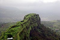
A panoramic view of the Pawna dam can be seen from the fort.
Places nearby
- Malawali railway station
- Mumbai-Pune ExpresswayMumbai-Pune ExpresswayThe Mumbai Pune Expressway , officially the Yashwantrao Chavan Expressway is India's first six-lane concrete, high-speed, access controlled tolled expressway. It spans a distance of connecting Mumbai, the administrative capital of Maharashtra and the financial capital of India, with Pune, an...
(10 km) - Bhaja CavesBhaja CavesBhaja Caves are a group of 22 rock-cut caves dating back to 200 BC located at Karli, near Lonavala, Maharashtra. The location of Bhaja caves is not far from location of Karla Caves and these are stylistically similar to the Karla Caves...
(2 km from Malawali), once home to Buddhist monks - Karla CavesKarla CavesThe Karla Caves or Karle Caves are a complex of ancient Indian Buddhist rock-cut cave shrines developed over two periods – from the 2nd century BC to the 2nd century AD, and from the 5th century to the 10th century. The oldest of the cave shrines is believed to date back to 160 BC...
- Lonavala hill stationHill stationA hill station is a town located at a higher elevation than the nearby plain or valley. The term was used mostly in colonial Asia , but also in Africa , for towns founded by European colonial rulers as refuges from the summer heat, up where temperatures are cooler...
(20 km) - Bushi Dam from Lonavala Market
- Ambey Valley Around 22 km from Bushi Dam
External links
For more information and pictures about Lohagad please visit Lohagad Fort