
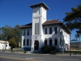
Live Oak, Florida
Encyclopedia
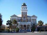
Suwannee County, Florida
Suwannee County is a county located in the state of Florida. As of 2000, the population was 34,844. The U.S. Census Bureau 2005 estimate for the county was 38,624 . Its county seat is Live Oak, Florida. Suwannee County was a dry county until August, 2011.....
, Florida
Florida
Florida is a state in the southeastern United States, located on the nation's Atlantic and Gulf coasts. It is bordered to the west by the Gulf of Mexico, to the north by Alabama and Georgia and to the east by the Atlantic Ocean. With a population of 18,801,310 as measured by the 2010 census, it...
. The city is the county seat
County seat
A county seat is an administrative center, or seat of government, for a county or civil parish. The term is primarily used in the United States....
of Suwannee County and is located east of Tallahassee, Florida
Tallahassee, Florida
Tallahassee is the capital of the U.S. state of Florida. It is the county seat and only incorporated municipality in Leon County, and is the 128th largest city in the United States. Tallahassee became the capital of Florida, then the Florida Territory, in 1824. In 2010, the population recorded by...
. The population was 6,480 at the 2000 census. As of 2004, the population recorded by the U.S. Census Bureau is 6,828 http://www.census.gov/popest/cities/tables/SUB-EST2004-04-12.xls.
U.S. Highway 90
U.S. Route 90
U.S. Route 90 is an east–west United States highway. Despite the "0" in its route number, U.S. 90 never was a full coast-to-coast route; it has always ended at Van Horn, Texas. A short-lived northward extension to U.S...
, U.S. Highway 129
U.S. Route 129
U.S. Route 129 is an offshoot route of U.S. Route 29, which it intersects near Athens, Georgia. US 129 currently runs for 582 miles from Knoxville, Tennessee, to Chiefland, Florida, at U.S. Route 19 and U.S. Route 98. It passes through the states of Tennessee, North Carolina, Georgia and Florida...
and Interstate 10
Interstate 10
Interstate 10 is the fourth-longest Interstate Highway in the United States, after I-90, I-80, and I-40. It is the southernmost east–west, coast-to-coast Interstate Highway, although I-4 and I-8 are further south. It stretches from the Pacific Ocean at State Route 1 in Santa Monica,...
are major highways running through Live Oak.
One other Florida
Florida
Florida is a state in the southeastern United States, located on the nation's Atlantic and Gulf coasts. It is bordered to the west by the Gulf of Mexico, to the north by Alabama and Georgia and to the east by the Atlantic Ocean. With a population of 18,801,310 as measured by the 2010 census, it...
county also has a community named Live Oak, which is located in Washington County
Washington County, Florida
Washington County is a county located in the state of Florida. As of 2000, the population was 20,973. The U.S. Census Bureau 2005 estimate for the county was 22,299. Its county seat is Chipley, Florida...
.
History
The history of Live Oak dates back to before the Civil War, in the 1840s and 1850s. Before it was a town, it was a popular gathering place for railroad workers. The beautiful landscape, which provided an abundant amount of shade and fresh spring water, was ideal for workers looking for somewhere to rest. After the Civil War, the population began to grow tremendously. By 1880, the town was already starting to take its current shape.Geography
Live Oak is located at 30.294570°N 82.985931°W. Live Oak is located within Suwannee County, which is surrounded on three sides by the Suwannee RiverSuwannee River
The Suwannee River is a major river of southern Georgia and northern Florida in the United States. It is a wild blackwater river, about long. The Suwannee River is the site of the prehistoric Suwannee Straits which separated peninsular Florida from the panhandle.-Geography:The river rises in the...
made famous by Stephen Foster
Stephen Foster
Stephen Collins Foster , known as the "father of American music", was the pre-eminent songwriter in the United States of the 19th century...
.
According to the United States Census Bureau
United States Census Bureau
The United States Census Bureau is the government agency that is responsible for the United States Census. It also gathers other national demographic and economic data...
, the city has a total area of 6.96 square miles (18 km²), all land.
The land mass of Suwannee County sits on a limestone bed riddled with underground freshwater streams that surface in dozens of beautiful springs. This phenomenon, known as "Karst topography
Karst topography
Karst topography is a geologic formation shaped by the dissolution of a layer or layers of soluble bedrock, usually carbonate rock such as limestone or dolomite, but has also been documented for weathering resistant rocks like quartzite given the right conditions.Due to subterranean drainage, there...
", gives the area a local supply of renewable fresh water and abundant sources of fishing. It is also known as a world class cave diving
Cave diving
Cave diving is a type of technical diving in which specialized equipment is used to enable the exploration of caves which are at least partially filled with water. In the United Kingdom it is an extension of the more common sport of caving, and in the United States an extension of the more common...
site for SCUBA
Scuba diving
Scuba diving is a form of underwater diving in which a diver uses a scuba set to breathe underwater....
enthusiasts.
Demographics
As of the censusCensus
A census is the procedure of systematically acquiring and recording information about the members of a given population. It is a regularly occurring and official count of a particular population. The term is used mostly in connection with national population and housing censuses; other common...
of 2000, there were 6,480 people, 2,361 households, and 1,562 families residing in the city. The population density
Population density
Population density is a measurement of population per unit area or unit volume. It is frequently applied to living organisms, and particularly to humans...
was 931.7 per square mile (359.5/km²). There were 2,745 housing units at an average density of 394.7 per square mile (152.3/km²). The racial makeup of the city was 58.24% White, 37.65% African American, 0.25% Native American, 0.79% Asian, 0.03% Pacific Islander, 1.84% from other races
Race (United States Census)
Race and ethnicity in the United States Census, as defined by the Federal Office of Management and Budget and the United States Census Bureau, are self-identification data items in which residents choose the race or races with which they most closely identify, and indicate whether or not they are...
, and 1.20% from two or more races. Hispanic or Latino of any race were 8.61% of the population.
There were 2,361 households out of which 30.5% had children under the age of 18 living with them, 39.5% were married couples living together, 22.0% had a female householder with no husband present, and 33.8% were non-families. 28.4% of all households were made up of individuals and 13.5% had someone living alone who was 65 years of age or older. The average household size was 2.60 and the average family size was 3.13.
In the city the population was spread out with 26.6% under the age of 18, 11.0% from 18 to 24, 24.1% from 25 to 44, 20.1% from 45 to 64, and 18.1% who were 65 years of age or older. The median age was 36 years. For every 100 females there were 93.3 males. For every 100 females age 18 and over, there were 88.6 males.
The median income for a household in the city was $24,380, and the median income for a family was $29,099. Males had a median income of $22,403 versus $20,154 for females. The per capita income
Per capita income
Per capita income or income per person is a measure of mean income within an economic aggregate, such as a country or city. It is calculated by taking a measure of all sources of income in the aggregate and dividing it by the total population...
for the city was $12,374. About 19.6% of families and 23.9% of the population were below the poverty line, including 27.9% of those under age 18 and 20.9% of those age 65 or over.
External links
- Live Oak Daily Democrat historical newspaper for Live Oak, Florida fully and openly available in the Florida Digital Newspaper Library
- City of Live Oak City website
- Live Oak Suwannee Online