Little Saskatchewan River
Encyclopedia
The Little Saskatchewan River is a river in western Manitoba
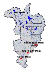
. It originates in Riding Mountain National Park at Lake Audy and flows about 65 miles (104.6 km) south through the communities of Minnedosa
and Rapid City
. Its approximate length is 185 km. It joins the Assiniboine River
about 6 miles (9.7 km) west of Brandon
. The watershed has an area of 1400 square miles (3,626 km²). The watershed includes numerous lakes and three man made reservoirs (Minnedosa Lake, Rapid City Reservoir and Lake Wahtopanah
.
In 1911 the Geographic Board of Canada adopted the name Minnedosa River but restored the original name in 1978. Some early settlers to the area arrived when the river was in flood and thought it was the Saskatchewan River
.
The maximum mean daily discharge near Rivers, Manitoba was 3640 cubic feet (103.1 m³) per second on April 14, 1969. Average annual runoff is about 115000 acre.ft, the equivalent of 1.4 inches (35.6 mm) from the entire area or about 7% of the total annual precipitation.
Manitoba
Manitoba is a Canadian prairie province with an area of . The province has over 110,000 lakes and has a largely continental climate because of its flat topography. Agriculture, mostly concentrated in the fertile southern and western parts of the province, is vital to the province's economy; other...
. It originates in Riding Mountain National Park at Lake Audy and flows about 65 miles (104.6 km) south through the communities of Minnedosa
Minnedosa, Manitoba
Minnedosa is a town in the southwestern part of the Canadian province of Manitoba. Situated 50 kilometres north of Brandon, Manitoba on the Little Saskatchewan River, the name means "flowing water" in Sioux. The population of Minnedosa reported in the 2006 Statistics Canada Census was 2,474...
and Rapid City
Rapid City, Manitoba
Rapid City is a town in southwest Manitoba, Canada located about 30km north of Brandon, Manitoba. Rapid City is situated in the Rural Municipality of Saskatchewan and is built on the banks of the Little Saskatchewan River. The town is a small farming community with a population of about five...
. Its approximate length is 185 km. It joins the Assiniboine River
Assiniboine River
The Assiniboine River is a river that runs through the prairies of Western Canada in Saskatchewan and Manitoba. It is a tributary of the Red River. The Assiniboine is a typical meandering river with a single main channel embanked within a flat, shallow valley in some places and a steep valley in...
about 6 miles (9.7 km) west of Brandon
Brandon, Manitoba
Brandon is the second largest city in Manitoba, Canada, and is located in the southwestern area of the province. Brandon is the largest city in the Westman region of Manitoba. The city is located along the Assiniboine River. Spruce Woods Provincial Park and CFB Shilo are a relatively short distance...
. The watershed has an area of 1400 square miles (3,626 km²). The watershed includes numerous lakes and three man made reservoirs (Minnedosa Lake, Rapid City Reservoir and Lake Wahtopanah
Lake Wahtopanah
Lake Wahtopanah, also known as Rivers Reservoir, is a lake on the Little Saskatchewan River near the town of Rivers, Manitoba. Its dam was built by the Prairie Farm Rehabilitation Administration in 1960 to supplement water supplies for irrigation. It also provides the water supply for the town of...
.
In 1911 the Geographic Board of Canada adopted the name Minnedosa River but restored the original name in 1978. Some early settlers to the area arrived when the river was in flood and thought it was the Saskatchewan River
Saskatchewan River
The Saskatchewan River is a major river in Canada, approximately long, flowing roughly eastward across Saskatchewan and Manitoba to empty into Lake Winnipeg...
.
The maximum mean daily discharge near Rivers, Manitoba was 3640 cubic feet (103.1 m³) per second on April 14, 1969. Average annual runoff is about 115000 acre.ft, the equivalent of 1.4 inches (35.6 mm) from the entire area or about 7% of the total annual precipitation.

