

List of villages and settlements in Namibia
Encyclopedia
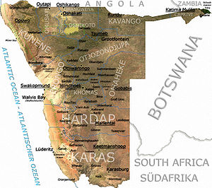
Namibia
Namibia, officially the Republic of Namibia , is a country in southern Africa whose western border is the Atlantic Ocean. It shares land borders with Angola and Zambia to the north, Botswana to the east and South Africa to the south and east. It gained independence from South Africa on 21 March...
n government
Government
Government refers to the legislators, administrators, and arbitrators in the administrative bureaucracy who control a state at a given time, and to the system of government by which they are organized...
has vested in them: Places with a village council are villages, they are the smallest entities of local government. All other places except cities and towns are not self-governed, they are called settlements.
Villages
- AranosAranosAranos is a settlement in Hardap Region, Namibia. Since August 2010 it has town status. The place normally receives an annual average rainfall of , although in the 2010/2011 rainy season were measured.-Politics:...
- AroabAroabAroab is a village with a population of approximately 2500 in the Keetmanshoop district in the Karas region in the southeast of Namibia. Being situated on the edge of the Kalahari desert, the average annual rainfall is about 150-200mm...
- BersebaBersebaBerseba is a village in the Karas Region of southern Namibia and the district capital of the Berseba electoral constituency...
- Bethanie
- Gibeon
- GochasGochasGochas is a village in Hardap Region, Namibia. It is located southeast of Mariental on the way to the Mata Mata border post to the Kgalagadi Transfrontier Park. The village has been the main settlement of the ǃKharakhoen , a subtribe of the Nama people, since 1889.-References:...
- KamanjabKamanjabKamanjab is a village and a constituency in the Kunene region in Namibia. It has a population of 6,012.-References:...
- KoësKoësKoës is a village in the Karas Region of south-eastern Namibia. It belongs to the Keetmanshoop Rural electoral constituency.-References:...
- KongolaKongolaKongola is a village and the district capital of the Kongola Constituency in Namibia's Caprivi Strip. It is situated on the national road B8 . Kongola has a petrol station and a wholesaler. Although the village is situated on a national power line, it has not yet been connected to the electricity...
- MaltahöheMaltahöheMaltahöhe is a village in Namibia, about 110 km west of Mariental in the Hardap Region.The settlement has about 2,400 inhabitants. Maltahöhe got its name from the German Hauptmann Henning von Burgsdorf who supervised a police station of the German colonial administration there in 1895. He...
- LeonardvilleLeonardville, NamibiaLeonardville is a village in Omaheke Region in eastern Namibia. It belongs to the Aminuis electoral constituency. The place normally receives an annual average rainfall of , although in the 2010/2011 rainy season were measured....
- OshikukuOshikukuOshikuku is a village in Omusati Region in the north of Namibia. It is the district capital of Oshikuku Constituency and scheduled to be upgraded to "town" status before November 2010....
- OtaviOtaviOtavi is a town of 4,000 inhabitants in the Otjozondjupa Region of central Namibia. It is the district capital of the Otavi electoral constituency. Most of the area is dolomitic and the district was in the past renowned for its mineral wealth...
- OtjineneOtjineneOtjinene is a village in the Omaheke Region of Namibia. Otjinene is the district capital of Otjinene Constituency. As of July 2004, the town had no tarred streets.-References:...
- Outapi
- RunduRunduRundu is the capital of the Kavango Region, northern Namibia, on the border with Angola on the banks of the Okavango River about 1000 m above sea level. The place normally receives an annual average rainfall of , although in the 2010/2011 rainy season were measured.Rundu grows rapidly...
- StamprietStamprietStampriet is a village in Hardap Region, Namibia. It is located 10 km north of Mariental.-Local authority results, 2010:In the 2010 local authority election, a total of 349 votes were cast in the village. SWAPO won with approximately 74% of the vote...
- UisUisUis is a village located in Erongo Region, Namibia. It belongs to the Dâures electoral constituency. Located in the former Damaraland, it is known for the local mineral wealth. The settlement has approximately 3,600 inhabitants and owns of land....
- TsesTsesTses is a village in Karas Region, Namibia with a population of approximately 1000; probably 1000 more live in the surrounding semi-desert farming hinterland. It is situated one kilometre off the main B1 highway from Windhoek to Cape Town and Johannesburg, opposite the turning to Berseba and...
- WitvleiWitvleiWitvlei is a populated settlement in Steinhausen Constituency, Omaheke Region, Namibia. It is known for producing high quality meat.-References:...
- OkambondeOkambondeOkambonde is a village in the northern part of Namibia. It is situated just east of Oniipa and is one of the villages used as entrance into some Uukwanyama villages such as Oshaango, Onamukulo, Okongo, and Eenhana....
Settlements
- AusAus, NamibiaAus is a village in Karas Region in southern Namibia. It lies on a railway line and the B4 national road, 230 km west of Keetmanshoop and about 125 km east of Lüderitz. Trains from Keetmanshoop now terminate at the village but formerly continued on to Lüderitz. The village is small but...
- AussenkehrAussenkehrAussenkehr is a farm on the banks of the Orange River in the south of Namibia hard on the border with South Africa. Aussenkehr falls within the Karasburg Constituency of the Karas Region and is situated downstream of Noordoewer. Over time, Aussenkehr has evolved into a large settlement...
- in the process of gaining town status - FransfonteinFransfonteinFransfontein is a small settlement in Kunene Region, Namibia. It is the hometown of Deputy Prime Minister of Namibia Libertine Amathila.-References:...
- Groß Aub
- GrünauGrünau, NamibiaGrünau is a settlement in southern Namibia, west of Karasburg in the Karas region. It is linked to the South African border posts near Noordoewer via the B1 and Nakop via the B3. Grünau belongs to the Karasburg electoral constituency.-References:...
- HelmeringhausenHelmeringhausenHelmeringhausen is a settlement in southern Namibia in the Berseba Constituency in the Karas Region. It is located 200 km northeast of Lüderitz and 500 km south of Windhoek on the crossing of the national roads C14 and C13 , and the road D414 .Helmeringhausen does not have an official governing...
- Hochfeld
- KalkfeldKalkfeldKalkfeld is a settlement in the Otjozondjupa region of Namibia. It is situated halfway between Omaruru and Otjiwarongo on the national road C33 and belongs to the Omatako electoral constituency. The place normally receives an annual average rainfall of , although in the 2010/2011 rainy season were...
- Kalkrand
- Klein AubKlein AubKlein Aub is a village in the Rehoboth Rural constituency in the Hardap Region of central Namibia. Situated on the junction of the unpaved roads C14 and D1290 it contains a store and two schools....
- KombatKombatKombat is a small settlement at the southern margin of the Otavi Mountainland in northern Namibia. It lies on the road between Otavi and Grootfontein. It was founded around a copper mine that was operated for many years during and before the 1970s by Tsumeb Corporation Limited...
- Möwe Bay
- NoordoewerNoordoewerNoordoewer is a town in southern Namibia. Its name means 'North Bank' in Afrikaans, in reference to the north bank of the Orange River, on which it is located...
- in the process of gaining town status - OkonjimaOkonjimaOkonjima is a village in Namibia. It is located among the Omboroko mountains,and overlooking is a small waterfall. The AfriCat Foundation is located in the village....
- OshikangoOshikangoOshikango is a village in northern Namibia and a border post to Angola. Since 2004 it is part of the town of Helao Nafidi but still maintains its own village council. It is the district capital of the Oshikango Constituency...
- OshiveloOshivelo- History :In early 2005, the first stage of the new Northern Railway was opened from Tsumeb, this section being 89km long. The next section runs to Oshikango near the Angolan border. The next section to be built may be to the iron ore mines at Cassinga....
- Rosh PinahRosh PinahRosh Pinah is a mining town located in southern Namibia, close to the border with South Africa. West of the town lies Diamond Area 1, the main diamond mining area of Namibia. Rosh Pinah belongs to the Oranjemund electoral constituency. The town is connected via road to Aus....
- SchuckmannsburgSchuckmannsburgSchuckmannsburg is an African village in the Caprivi Strip in northeastern Namibia with a population of about 800. It belongs to the Kabbe electoral constituency of the Caprivi Region...
- SeeheimSeeheimSeeheim is a settlement in Karas Region, southern Namibia. The only notable structures in Seeheim today are the hotel and the railway station; only a handful of people live there. Seeheim belongs to the Keetmanshoop Rural electoral constituency.- History :...
- SeeisSeeisSeeis [ˈseːaɪs] is a small settlement in the Khomas Region of central Namibia. It is situated on the B6 national road east of Hosea Kutako International Airport on the turnoff of the dirt road D1458. The Seeis Rivier, an ephemeral river, cuts the settlement...
- SesfonteinSesfonteinSesfontein is a settlement in the Kunene Region of Namibia. It is the district capital of the Sesfontein electoral constituency, its population is 7,358. Sesfontein derives its name from the six fountains which have their source in the vicinity....
- SolitaireSolitaire, NamibiaSolitaire is a small settlement in the Khomas Region of central Namibia near the Namib-Naukluft National Park. It features the only gasoline station, post office, and the only general dealer between the dunes at Sossusvlei and the coast at Walvis Bay, as well as to the capital Windhoek...
- TrekkopjeTrekkopjeTrekkopje is a settlement in Namibia, 45 kilometres north-east of Swakopmund on the road to Usakos. About 20 km to the north the Trekkopje uranium mine is under construction. It will be Southern Africa's largest uranium mine when it reaches full production capacity in 2013....
- UutapiUutapiOutapi, also known as Uutapi and Ombalantu, is a town in northern Namibia near the border with Angola situated 90km northwest of Oshakati. It is the capital of Omusati region and the district capital of the Outapi electoral constituency...
- WarmbadWarmbad, NamibiaWarmbad is a settlement located in the Karas Region of southern Namibia. It is situated south of Karasburg at the Homs River, close to the border with South Africa, and belongs to the Karasburg electoral constituency.First occupied by traders, hunters, and missionaries of different congregations,...
- Wilhelmstal
See also
- List of cities and towns in Namibia
- Geography of NamibiaGeography of NamibiaAt , Namibia is the world's thirty-fourth largest country . After Mongolia, Namibia is the least densely populated country in the world .-Geographical areas:...
- Regions of NamibiaRegions of NamibiaThe administrative division of Namibia is tabled by Delimitation Commissions and accepted or declined by the National Assembly. The First Delimitation Commission chaired by Judge President Johan Strydom suggested in 1992 that Namibia be divided into 13 Regions, a number that has not been amended...