
Grünau, Namibia
Encyclopedia
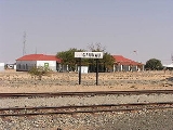
Grünau is a settlement in southern Namibia
, west of Karasburg
in the Karas region. It is linked to the South African border posts near Noordoewer
via the B1
and Nakop
via the B3
. Grünau belongs to the Karasburg electoral constituency
.
Namibia
Namibia, officially the Republic of Namibia , is a country in southern Africa whose western border is the Atlantic Ocean. It shares land borders with Angola and Zambia to the north, Botswana to the east and South Africa to the south and east. It gained independence from South Africa on 21 March...
, west of Karasburg
Karasburg
Karasburg is city of 4,000 inhabitants in the Karas Region of southern Namibia and the district capital of the Karasburg electoral constituency. It lies at the heart of the southern Namibian sheep farming industry.- Location :...
in the Karas region. It is linked to the South African border posts near Noordoewer
Noordoewer
Noordoewer is a town in southern Namibia. Its name means 'North Bank' in Afrikaans, in reference to the north bank of the Orange River, on which it is located...
via the B1
B1 road (Namibia)
The B1 is one of the most important roads in Namibia, passing through the centre of the country in a north-south direction. It connects Noordoewer on the South African border with Oshikango in the north on the Angolan border...
and Nakop
Nakop
Nakop is a small town and border post in southeastern Namibia, on its border with South Africa. It lies ten kilometres north of the Orange River....
via the B3
B3 road (Namibia)
The B3 is a national highway of Namibia. It passes through the Karas Region of Namibia in the south for 160 kilometres, connecting Nakop near South Africa to the B1 at Grünau.-References:*http://www.hentiesbaytourism.com/touristinfo.htm...
. Grünau belongs to the Karasburg electoral constituency
Karasburg Constituency
Karasburg is a constituency in the Karas Region of Namibia, with a population of 16,000. The main towns are Karasburg and Grünau; other populated places include Warmbad and Aussenkehr, and the border settlements of Ariamsvlei and Noordoewer...
.