

List of plateaus and mesas of Utah
Encyclopedia
Plateau
In geology and earth science, a plateau , also called a high plain or tableland, is an area of highland, usually consisting of relatively flat terrain. A highly eroded plateau is called a dissected plateau...
s and mesa
Mesa
A mesa or table mountain is an elevated area of land with a flat top and sides that are usually steep cliffs. It takes its name from its characteristic table-top shape....
s of Utah
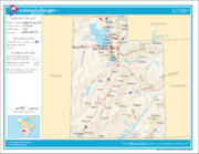
Utah
Utah is a state in the Western United States. It was the 45th state to join the Union, on January 4, 1896. Approximately 80% of Utah's 2,763,885 people live along the Wasatch Front, centering on Salt Lake City. This leaves vast expanses of the state nearly uninhabited, making the population the...
.
Garfield CountyGarfield County, UtahGarfield County is a county located in the U.S. state of Utah. As of 2000 the population was 4,735. It was named for James A. Garfield, President of the United States in 1881. Its county seat and largest city is Panguitch.-Geography:...
A
- Aquarius PlateauAquarius PlateauThe Aquarius Plateau is a physiographic region within Garfield and Wayne counties in south-central Utah. The plateau, an uplift on the much larger Colorado Plateau, is the highest in North America...
M
- Markagunt PlateauMarkagunt PlateauThe Markagunt Plateau is an plateau located in southwestern Utah between Interstate 15 and U.S. Route 89. It is one of the plateaus that make up the High Plateaus Section of the Colorado Plateau. The plateau encompasses Cedar Breaks National Monument and is part of Cedar Mountain District of...
S
- Sevier Plateau
W
- Wildcat Mesa
Uintah CountyUintah County, UtahThis page deals with the Utah County. For the Wyoming County, see Uinta County, Wyoming.Uintah County is a county located in the U.S. state of Utah. As of 2000 the population was 25,224 and by 2009 was estimated at 31,536. It was named for the Ute Indians, the tribe that lives in the basin. Its...
D
- Diamond Mountain Plateau
E
- East Tavaputs Plateau
Y
- Yampa Plateau
Washington CountyWashington County, UtahAs of the census of 2000, there were 90,354 people, 29,939 households, and 23,442 families residing in the county. The population density was 37 people per square mile . There were 36,478 housing units at an average density of 15 per square mile...
H
- Hurricane Mesa
K
- Kolob Terrace
S
- Smith Mesa
Wayne CountyWayne County, UtahWayne County is a county located in the U.S. state of Utah. It was formed from Piute County in 1892. The county gets its name from a man who served as delegate to the constitutional convention, in honor of his son who was dragged to death by a horse. As of 2000 the population was 2,509, and by...
A
- Awapa Plateau
S
- Sams Mesa
- South Caineville Mesa
T
- Thompson Mesa
See also
- List of mountain ranges of Utah
- List of rivers of Utah
- List of valleys of Utah