

List of mountains and hills of Saint Helena, Ascension and Tristan da Cunha
Encyclopedia
This is a list of mountains and hills in Saint Helena, Ascension and Tristan da Cunha
, listed by height.

Saint Helena, Ascension and Tristan da Cunha
Saint Helena, Ascension and Tristan da Cunha is a British overseas territory and overseas territory of the European Union consisting of the islands of Saint Helena, Ascension Island and the Tristan da Cunha group...
, listed by height.
List of mountains and hills
Over 1000m
| Mountain or hill | Height | Island | Notes |
|---|---|---|---|
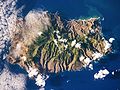
| Queen Mary's Peak Queen Mary's Peak Queen Mary's Peak is the summit of the island of Tristan da Cunha, in the South Atlantic Ocean. It has an elevation of 2,062 metres above sea level. It is named after Mary of Teck, the Queen consort of King George V... |
2062 metres (6,765.1 ft) | Tristan da Cunha Tristan da Cunha Tristan da Cunha is a remote volcanic group of islands in the south Atlantic Ocean and the main island of that group. It is the most remote inhabited archipelago in the world, lying from the nearest land, South Africa, and from South America... |
an Ultra prominent peak Ultra prominent peak An ultra prominent peak, or Ultra for short, is a mountain with a topographic prominence of or more. There are a total of roughly 1,524 such peaks in the world. Some are famous even to non-climbers, such as Mount Everest, Aconcagua, and Mount McKinley , while others are much more obscure... tallest in whole overseas territory and on the island |
| Mount Olav | 1969 metres (6,460 ft) | Tristan da Cunha |
750m to 1000m
| Mountain or hill | Height | Island | Notes |
|---|---|---|---|
| Edinburgh Peak | 910 metres (2,985.6 ft) | Gough Island Gough Island Gough Island , also known historically as Gonçalo Álvares or Diego Alvarez, is a volcanic island in the South Atlantic Ocean. It is a dependency of Tristan da Cunha and part of the British overseas territory of Saint Helena, Ascension and Tristan da Cunha... (Tristan da Cunha) |
tallest on the island |
| Expedition Peak | 909 metres (2,982.3 ft) | Gough Island | |
| Green Mountain Green Mountain Green Mountain is a common name for "The Peak", the highest point, on Ascension Island which has gained some fame for claims that it is one of very few large-scale artificial forests.-History and Vegetation:... "The Peak" |
859 metres (2,818.2 ft) | Ascension Island Ascension Island Ascension Island is an isolated volcanic island in the equatorial waters of the South Atlantic Ocean, around from the coast of Africa and from the coast of South America, which is roughly midway between the horn of South America and Africa... |
tallest on the island |
| Centre Rowett | 836 metres (2,742.8 ft) | Gough Island | highest of the Mount Rowett peaks |
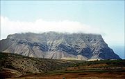
| Diana's Peak Diana's Peak Diana's Peak is the highest point, at , on the island of Saint Helena, a British overseas territory in the South Atlantic Ocean. It is of volcanic origin. It was proclaimed a national park in March 1996, the first on the island. It is covered in tree fern thicket.The peak is located at the... |
818 metres (2,683.7 ft) | Saint Helena Saint Helena Saint Helena , named after St Helena of Constantinople, is an island of volcanic origin in the South Atlantic Ocean. It is part of the British overseas territory of Saint Helena, Ascension and Tristan da Cunha which also includes Ascension Island and the islands of Tristan da Cunha... |
tallest on the island |
| Nigel's Cap | 811 metres (2,660.8 ft) | Gough Island | |
| North Rowett | 808 metres (2,650.9 ft) | Gough Island | one of the Mount Rowett peaks |
| West Rowett | 805 metres (2,641.1 ft) | Gough Island | one of the Mount Rowett peaks |
| High Peak | 798 metres (2,618.1 ft) | Saint Helena | |
| False Peak | 757 metres (2,483.6 ft) | Gough Island |
500m to 750m
| Mountain or hill | Height | Island | Notes |
|---|---|---|---|
| Sandy Bay Ridge | 747 metres (2,450.8 ft) | Saint Helena | |
| Sea-hen Crag | 710 metres (2,329.4 ft) | Gough Island | |
| High Hill | 707 metres (2,319.6 ft) | Saint Helena | |
| White Point | 694 metres (2,276.9 ft) | Saint Helena | |
| Hag's Tooth | 692 metres (2,270.3 ft) | Gough Island | |
| Hooper's Ridge | 691 metres (2,267.1 ft) | Saint Helena | |
| Flagstaff Hill | 688 metres (2,257.2 ft) | Saint Helena | |
| Halley's Mount | 680 metres (2,231 ft) | Saint Helena | named for Edmond Halley Edmond Halley Edmond Halley FRS was an English astronomer, geophysicist, mathematician, meteorologist, and physicist who is best known for computing the orbit of the eponymous Halley's Comet. He was the second Astronomer Royal in Britain, following in the footsteps of John Flamsteed.-Biography and career:Halley... |
| Tavistock Crag | 640 metres (2,099.7 ft) | Gough Island | |
| The Saddle | 639 metres (2,096.5 ft) | Saint Helena | |
| Triple Peak | 634 metres (2,080.1 ft) | Gough Island | |
| The Haystack | 616 metres (2,021 ft) | Saint Helena | highest point of The Barn |
| Weather Post | 608 metres (1,994.8 ft) | Ascension Island | |
| Long Range | 588 metres (1,929.1 ft) | Saint Helena | |
| Mount Argus | 587 metres (1,925.9 ft) | Gough Island | |
| High Knoll High Knoll Fort High Knoll Fort is a redoubt-style fort of the English East India Company on Saint Helena, an island and British overseas territory in the South Atlantic Ocean... |
584 metres (1,916 ft) | Saint Helena | |
| Joan Hill | 579 metres (1,899.6 ft) | Saint Helena | |
| Blue Point | 573 metres (1,879.9 ft) | Saint Helena | |
| Green Hill | 570 metres (1,870.1 ft) | Gough Island | |
| Stone Top Ridge | 566 metres (1,857 ft) | Saint Helena | height given near "The Bellstone" |
| Swale's Fen | 561 metres (1,840.6 ft) | Inaccessible Island Inaccessible Island Inaccessible Island is an extinct volcano, 14 km² in area, rising out of the South Atlantic Ocean 45 km southwest of Tristan da Cunha. Inaccessible Island is located at . It is part of the archipelago of Tristan da Cunha, which is part of the overseas territory of the United Kingdom,... (Tristan da Cunha) |
tallest on the island; on Gony Ridge |
| Red Hill | 546 metres (1,791.3 ft) | Ascension Island | ("The Ring") |
| White Hill | 543 metres (1,781.5 ft) | Saint Helena | |
| Devil's Ashpit | 536 metres (1,758.5 ft) | Ascension Island | location of NASA Challenger Centre |
| Piccolo Hill | 529 metres (1,735.6 ft) | Saint Helena | |
| White Hill | 525 metres (1,722.4 ft) | Ascension Island | |
| Boulder Hill | 510 metres (1,673.2 ft) | Inaccessible Island | on Gony Ridge |
250m to 500m
| Mountain or hill | Height | Island | Notes |
|---|---|---|---|
| Great Stone Top | 494 metres (1,620.7 ft) | Saint Helena | |
| Lot's Wife | 462 metres (1,515.7 ft) | Saint Helena | (also a rock off the north coast of Gough Island) |
| Lot | 454 metres (1,489.5 ft) | Saint Helena | |
| Cairn Peak | 323 metres (1,059.7 ft) | Inaccessible Island | |
| Sisters Peak | 445 metres (1,460 ft) | Ascension Island | |
| Boxwood Hill | 434 metres (1,423.9 ft) | Saint Helena | |
| Sandy Bay Barn | 431 metres (1,414 ft) | Saint Helena | |
| Rupert's Hill | 405 metres (1,328.7 ft) | Saint Helena | |
| Horse Point | 403 metres (1,322.2 ft) | Saint Helena | |
| Round Hill | 388 metres (1,273 ft) | Inaccessible Island | |
| Denstone Hill | 384 metres (1,259.8 ft) | Inaccessible Island | |
| Spoon Crater | 364 metres (1,194.2 ft) | Ascension Island | |
| Traveller's Hill | 357 metres (1,171.3 ft) | Ascension Island | also name of nearby RAF base |
| The Fid | 355 metres (1,164.7 ft) | Gough Island | |
| South East Crater | 349 metres (1,145 ft) | Ascension Island | |
| 337 metres (1,105.6 ft) | Nightingale Island Nightingale Island Nightingale Island is an island in the South Atlantic Ocean, 3 km² in area, part of the Tristan da Cunha group of islands. They are administered by the United Kingdom as part of the overseas territory of Saint Helena, Ascension and Tristan da Cunha.... (Tristan da Cunha) |
tallest on the island | |
| Joe's Hill | 330 metres (1,082.7 ft) | Inaccessible Island | |
| Lady Hill | 329 metres (1,079.4 ft) | Ascension Island | |
| South Hill | 323 metres (1,059.7 ft) | Inaccessible Island | |
| Sugar Loaf Hill | 272 metres (892.4 ft) | Saint Helena | |
| Ladder Hill | 268 metres (879.3 ft) | Saint Helena | |
| Cross Hill | 263 metres (862.9 ft) | Ascension Island |
50m to 250m
| Mountain or hill | Height | Island | Notes |
|---|---|---|---|
| Bears Back | 240 metres (787.4 ft) | Ascension Island | |
| Dark Slope Crater | 234 metres (767.7 ft) | Ascension Island | |
| Broken Tooth | 228 metres (748 ft) | Ascension Island | ("East Crater") |
| South Gannet Hill | 228 metres (748 ft) | Ascension Island | |
| Goat Pound Ridge | 227 metres (744.8 ft) | Saint Helena | |
| Richmond Hill | 210 metres (689 ft) | Gough Island | SE of the island, near the Meteorological Station |
| Pig Beach Hill | 207 metres (679.1 ft) | Inaccessible Island | |
| Egg Island | 79 metres (259.2 ft) | Saint Helena |
Other hills and hill features
NB: Many of these hills and features are over 200m.| Mountain or hill | Height | Island | Notes |
|---|---|---|---|
| Cat Hill | Ascension Island | location of the main US base | |
| Letter Box | Ascension Island | ||
| Devil's Riding School | Ascension Island | a crater | |
| Devil's Cauldron | Ascension Island | a crater, near Weather Post | |
| Round Hill | Ascension Island | ||
| Booby Hill | Ascension Island | ||
| Holland's Crater | Ascension Island | ||
| Dune Hills | Inaccessible Island | ||
| Long Ridge | Inaccessible Island | ||
| Little Stone Top | Saint Helena | ||
| Mount Vesey | Saint Helena | ||
| Drummond's Point | Saint Helena | ||
| Munden's Mount | Saint Helena | ||
| Green Hill | Saint Helena | ||
| Cuckold's Point | Saint Helena | near Diana's Peak | |
| Mount Actaeon | Saint Helena | near Diana's Peak | |
| Mount Ross | Saint Helena | ||
| Bunker's Hill | Saint Helena | ||
| Silver Hill | Saint Helena | ||
| Blue Hill Blue Hill, Saint Helena Blue Hill is a hill and one of eight districts of the island of Saint Helena, a British overseas territory in the South Atlantic Ocean, located in the west and southwest of the island. Its main settlement, with the location of the community centre, is Blue Hill Village... |
Saint Helena | ||
| The Saddle | Saint Helena | ||
| Beach Hill | Saint Helena | ||
| Horse Point | Saint Helena | ||
| Turk's Cap | Saint Helena | ||
| Thompson's Hill | Saint Helena | ||
| King & Queen Rocks | Saint Helena | ||
| Horse Ridge | Saint Helena | ||
| Dry Gut Hill | Saint Helena | ||
| Botley's Point | Saint Helena | ||
| Rock Mount | Saint Helena | ||
| Sheep Knoll | Saint Helena | ||
| Powell's Valley Hill | Saint Helena | ||
| Brown's Hill | Saint Helena | ||
| Bonfire Ridge | Saint Helena | ||
| Woodland's Hill | Saint Helena | ||
| Isaac's Hill | Saint Helena | ||
| Round Hill | Tristan da Cunha | ||
| Cave Gulch Hill | Tristan da Cunha | ||
| Red Hill | Tristan da Cunha |
See also
- Geography of Saint HelenaGeography of Saint HelenaSaint Helena is an island in the South Atlantic Ocean, about mid-way between South America and Africa, at the geographic coordinates . St Helena has a land area of 122 square kilometres and is part of a wider territory called Saint Helena, Ascension and Tristan da Cunha which includes Ascension...
- Geography of Tristan da CunhaGeography of Tristan da CunhaTristan da Cunha is an archipelago of five islands in the southern Atlantic Ocean, the largest of which is the island of Tristan da Cunha itself and the second-largest the remote bird haven Gough Island...
External links
- Google Terrain map of St Helena
Sources
- Gizimap's St Helena & Dependencies (2011)