
List of city parks of Erie, Pennsylvania
Encyclopedia
This is a list of the city parks and playgrounds of Erie, Pennsylvania
. Those annotated with a ward affiliation are "officially named, designated, established, and located as public parks, public parks and playgrounds, and public playgrounds of the city." Also included here are selected parks operated by the Erie City School District
and nearby Millcreek
and Harborcreek townships. Erie County
no longer operates parks, having passed all of its holdings to local governments.
The same article ranked the parks for various characteristics:

Erie, Pennsylvania
Erie is a city located in northwestern Pennsylvania in the United States. Named for the lake and the Native American tribe that resided along its southern shore, Erie is the state's fourth-largest city , with a population of 102,000...
. Those annotated with a ward affiliation are "officially named, designated, established, and located as public parks, public parks and playgrounds, and public playgrounds of the city." Also included here are selected parks operated by the Erie City School District
Erie City School District
The Erie School District is the school district that serves metropolitan Erie, Pennsylvania in the United States. It is a member of the Northwest Tri-County IU 5....
and nearby Millcreek
Millcreek Township, Erie County, Pennsylvania
Millcreek Township is a township in Erie County, Pennsylvania, United States. The population was 53,515 at the 2010 census. It is the largest suburb of Erie, Pennsylvania and the sixth-largest municipality in the state; larger than the cities of Altoona and Harrisburg.Millcreek Township is home to...
and Harborcreek townships. Erie County
Erie County, Pennsylvania
Erie County is a county located in the U.S. state of Pennsylvania. As of 2010, the population was 280,566. Its county seat is the City of Erie.- Geography :...
no longer operates parks, having passed all of its holdings to local governments.
Statistics and rankings
The Erie Times-News discussed the city parks in their entirety in "City Boasts Dozens of Parks" on 4 June 2000. The city has 56 city parks, which includes:- 3 golf courses
- 11 undeveloped parks (Roma Park, McClelland Park)
- 12 passive parks, manicured but lacking recreational equipment (Perry Square, Gridley Park)
- 28 active parks, with playgrounds and/or sports facilities
- 12 ballfields (3 at 21st and Bauer Sts)
- 19½ basketball courts (4 at Burton Park)
- 14 tennis courts (6 at Frontier Park)
- 1 skate park (Columbus Park)
The same article ranked the parks for various characteristics:
- Largest: Glenwood
- Smallest: 19th and Wayne, and Euclid Park, each only 1/3 acre
- Most popular: Glenwood Park, Frontier Park, Walczak Park, and Rodger Young Park
- Hidden jewel: E 41st and Brewer has unique playground equipment
- Underappreciated: Hillside, McKinley, Columbus, Lighthouse, and Barbara Nitkiewicz Parks
- Best playgrounds: Glenwood, Burton, Rodger Young, and Liberty Parks
- Prettiest views: Chautauqua and Branch Parks have nice views of Lake ErieLake ErieLake Erie is the fourth largest lake of the five Great Lakes in North America, and the tenth largest globally. It is the southernmost, shallowest, and smallest by volume of the Great Lakes and therefore also has the shortest average water residence time. It is bounded on the north by the...
; Walczak Park has a panoramic view of city and lake; and Frontier Park has the arboretum.
Public partnerships
The City of Erie coordinates management of a number of city parks with commercial and public stakeholders interested in green space and what it means for quality of life and the economy. Major parks like Frontier Park and Perry Square have advocacy groups with formal relationships linking the city, the public, and corporate sponsors. Other parks, like McClelland Park, Washington Park, and Woodland Avenue Park are supported by neighborhood groups that seek development funds and advocate for their local community parkland. The mayor is planning a formal adopt-a-park program to recognize all non-governmental efforts to maintain city parks. The city also integrates city park improvements into city development projects, such as the major renovation underway involving Griswold Park near Union Station.List of parks
- Attorney Richard D. Agresti Baseball Field at Victory Playground is located at West 13th Street and Lincoln, nestled near the Interstate 79 interchange. It was developed by the city in 2003. It has a small playground, covered picnic area, and parking for about forty vehicles.(Ward 3) (See Victory Park)
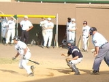
- Ainsworth FieldAinsworth FieldAinsworth Field is a 3,000 seat baseball stadium located in Erie, Pennsylvania. It hosted the Erie Sailors and other Erie based minor league teams between 1928 and 1994. In 1995, it was made obsolete for professional use by the opening of Jerry Uht Park...
is a baseball stadium located between West 22nd Street on the north, West 24th Street on the south, Cranberry Street on the east, and Washington Place on the west. It is on the grounds of Roosevelt Middle School. It is the former home of Erie minor league baseball, having been replaced by Jerry Uht ParkJerry Uht ParkJerry Uht Park is a 6,952-seat baseball-only stadium in Erie, Pennsylvania that hosted its first regular season baseball game on June 20, 1995, as the tenants of the facility, the Erie SeaWolves, defeated the Jamestown Jammers....
in 1995.
- The Ainsworth Athletic Field was dedicated on 25 August 1947 in honor of J. C. Ainsworth "in appreciation of his outstanding accomplishments as civic leader, physical director, friend, and counselor of the youth of this community." It was rededicated in 1980 by the Erie City School DistrictErie City School DistrictThe Erie School District is the school district that serves metropolitan Erie, Pennsylvania in the United States. It is a member of the Northwest Tri-County IU 5....
, which continues to provide funding for the stadium. Hallgren, Restifo, and Loop were the architects for the 1980 renovations, while Eriez Construction was the general contractor.
- Allen-Hetico Memorial Field. (see Bayview Park)
- Ted Amendola Memorial Field is located just south of the Bayfront Parkway at Front Street and Wallace. The field is located in Wallace Playground. (Ward 1)
- Asbury Farm Community Park is a recreational park located on the west side of Asbury Road, just south of West 38th Street in the Asbury section of southwestern Millcreek Township. It contains four tennis courts, a baseball field, sand volleyball, a playground, and a large covered picnic area. It is operated by Millcreek Township.
- Asbury Woods Nature Center, once known as the Asbury Park Nature Center, is 200 acre (0.809372 km²) of parkland located on the east side of Asbury Road, just south of West 38th Street in the Asbury section of southwestern Millcreek Township. The center is a large facility, with educational interpretation areas, a pavilion, gardens and fountains, and a large parking area. On the west side of Asbury Road is the associated greenway, with several miles of hiking trails through young deciduous forest and pine woods, as well as trails and raised wooden walkways through bogs and marshes along Walnut CreekWalnut Creek (Lake Erie)Walnut Creek is a tributary of Lake Erie in Erie County, Pennsylvania in the United States. It has a drainage basin of and is part of the Lake Erie Watershed....
. Despite its proximity to Erie International AirportErie International AirportErie International Airport / Tom Ridge Field is a public airport serving northwestern Pennsylvania and is located five miles southwest of the central business district of Erie, a city in Erie County. It features commercial service by regional airlines, connecting passengers to hubs in the...
only a mile away, it is quiet and secluded. The nature center and greenway are operated by the Millcreek Township School DistrictMillcreek Township School DistrictMillcreek Township School District is a school district serving Millcreek Township, a suburb of Erie, Pennsylvania. The total enrollment is 7,464 students.The District was the pilot district in the Start S.M.A.R.T...
.
- Avalon Park is a small wooded park just outside the city limits in Millcreek Township. Established in 1926 and adopted by the neighborhood in 1992, the park is situated on the north side of West 6th Street between California Street and Pittsburgh Street.
- Gregory Stuart Baldwin Park is a park located on West 26th Street between Berst Avenue and Geist Road in the Dock Junction section of the city. (Ward 6)
- Bayview Park is a park with a large open field, a basketball court, and a small playground with swings. It contains Allen-Hetico Memorial Field, which was developed by the city in 1983. It has a backstop and bleachers but lacks a baseball diamond and dugouts. The park has a wonderful view of Liberty Park and nearby marinas along West 2nd Street between Chestnut Street and Cherry Street, far above the Bayfront Parkway and Lake Erie. (Ward 4)
- Belle Valley Park is located in Millcreek Township.
- Roman Blaszczyk Field is a baseball field developed by the city in 1983. It is located south of East 12th Street between Wayne Street and the Bayfront ConnectorBayfront ConnectorThe Bayfront Connector is a , four-lane expressway that connects Interstate 90 to downtown Erie, Pennsylvania.- Route description :At the intersection of East 12th Street, the Bayfront Parkway becomes the Bayfront Connector and picks up the concurrency with Pennsylvania Route 290...
. The field is located within Kosciuszko Park in honor of Tadeusz KościuszkoTadeusz KosciuszkoAndrzej Tadeusz Bonawentura Kościuszko was a Polish–Lithuanian and American general and military leader during the Kościuszko Uprising. He is a national hero of Poland, Lithuania, the United States and Belarus...
. (Ward 2)
- George "Pat" Brabender Memorial Park is a baseball field developed by the city in 1983. It is located south of West 21st Street, north of West 23rd Street, east of Baur Avenue, and west of Emerson Avenue in the Dock Junction section of the city. (Ward 6)
- Jim Brutcher Field. (see Pulaski Park)
- Burton Park is an unmarked park and playground located to the south of East 38th Street and north of Pine Avenue. It contains tennis courts, basketball courts, and a large lawn. (Ward 5)
- John G. Carney Park is located at Woodlawn Avenue and Cameron Road, just northeast of the Bayfront ConnectorBayfront ConnectorThe Bayfront Connector is a , four-lane expressway that connects Interstate 90 to downtown Erie, Pennsylvania.- Route description :At the intersection of East 12th Street, the Bayfront Parkway becomes the Bayfront Connector and picks up the concurrency with Pennsylvania Route 290...
and west of the Erie Industrial Park. (Ward 5)
- Cassidy Park is a 22 acres (89,030.9 m²) passive recreation park planned for a location south of the intersection of Zimmerly Road and Love Road overlooking Walnut Creek in Millcreek Township. It is expected to include an indoor-outdoor picnic shelter, a small playground, a sand volleyball court, a fishing pier at creekside, restrooms, and parking for 50 to 75 vehicles. 17 acres (68,796.6 m²) of parkland would remain undeveloped except for nature trails. The township purchased the land, which was once known as the Cassidy Campground, in December 2006 for $316,500. The same company that developed Asbury Woods Nature Center, which is also along Walnut Creek, has been selected to develop Cassidy Park.
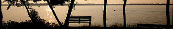
- Chautauqua Park is a small park located in a quiet northeastern Erie neighborhood on an elevated shoreline along Lake Erie. The park, which was developed in 1993, is located at the eastern end of Lakeside Drive. It has a covered picnic area and grill, as well as several benches from which one might enjoy the lake view. A utility road at the eastern edge of the park leads down to a stretch of beach, but a no-swimming sign is posted due to the city pumping station situated nearby. A root-stepped path down a sharp ravine on the western side of the park also leads to the waterfront. (Ward 1)
- Chestnut Street Park is located at Bayfront Parkway and Chestnut Street. The park has two boat launch ramps.
- Columbus Park is a small park off Cherry Street between West 15th Street and West 16th Street in the Little Italy section of the city. The park is named for Christopher ColumbusChristopher ColumbusChristopher Columbus was an explorer, colonizer, and navigator, born in the Republic of Genoa, in northwestern Italy. Under the auspices of the Catholic Monarchs of Spain, he completed four voyages across the Atlantic Ocean that led to general European awareness of the American continents in the...
. (Ward 3)
- Cranch Park is a small, unmarked park located on Lakeside Drive near Cranch Avenue. It has a grassy knoll, a rock outcropping down by the lakeshore, and two park benches from which to enjoy the wonderful view. The park (and avenue) are likely named in memory of Edward Cranch, MD (16 October 1851 - 20 May 1920), a prominent Erie homeopath.(Ward 1)
- Elk Creek Access is a small park along the west bank of Elk CreekElk Creek (Lake Erie)Elk Creek is a tributary of Lake Erie in Erie County, Pennsylvania in the United States. The creek is part of the Lake Erie Watershed and has a drainage basin of . Elk Creek is stocked with brown trout and steelhead by the Pennsylvania Fish and Boat Commission.- Course :Elk Creek has its origins...
in northwestern Girard TownshipGirard Township, Erie County, PennsylvaniaGirard Township is a township in Erie County, Pennsylvania, United States. The population was 5,133 at the 2000 census.-Geography:According to the United States Census Bureau, the township has a total area of , of which, of it is land and of it is water.-Demographics:As of the census of 2000,...
. Popular for its steelhead fishing, the park is situated between Pennsylvania Route 5Pennsylvania Route 5Pennsylvania Route 5 is a westward continuation of New York State Route 5 in Pennsylvania. It runs from North East, Pennsylvania at the New York-Pennsylvania border to near Erie, a total of . The highway is called the Purple Heart Highway and mostly called Lake Road...
on the south and Lake Erie on the north. The Pennsylvania Department of Conservation and Natural ResourcesPennsylvania Department of Conservation and Natural ResourcesThe Pennsylvania Department of Conservation and Natural Resources , established on July 1, 1995, is the agency in the U.S. State of Pennsylvania responsible for maintaining and preserving the state's 117 state parks and 20 state forests; providing information on the state's natural resources; and...
proposed to buy the 81 acres (327,795.7 m²) parcel in 2007 from Girard for $400,000 in order to join it to contiguous Erie Bluffs State Park, which has been the park's western neighbor since June 2004.
- Erie Bluffs State ParkErie Bluffs State ParkErie Bluffs State Park is a Pennsylvania state park in Girard and Springfield Townships, Erie County, Pennsylvania in the United States. The park is the largest undeveloped stretch of land overlooking Lake Erie in Pennsylvania. Erie Bluffs State Park is just north of Pennsylvania Route 5 near Lake...
is a 540 acres (2.2 km²) Pennsylvania state park with one mile (1.6 km) of undeveloped Lake Erie shoreline in Girard TownshipGirard Township, Erie County, PennsylvaniaGirard Township is a township in Erie County, Pennsylvania, United States. The population was 5,133 at the 2000 census.-Geography:According to the United States Census Bureau, the township has a total area of , of which, of it is land and of it is water.-Demographics:As of the census of 2000,...
and Springfield TownshipSpringfield Township, Erie County, PennsylvaniaSpringfield Township is a township in Erie County, Pennsylvania, United States. The population was 3,378 at the 2000 census.-Geography:According to the United States Census Bureau, the township has a total area of 37.8 square miles , of which, 37.7 square miles of it is land and...
. It has 90 feet (27.4 m) bluffs with deep forest, wetlands, archaeologic sites, and picturesque views of the lake. It is located on Pennsylvania Route 5Pennsylvania Route 5Pennsylvania Route 5 is a westward continuation of New York State Route 5 in Pennsylvania. It runs from North East, Pennsylvania at the New York-Pennsylvania border to near Erie, a total of . The highway is called the Purple Heart Highway and mostly called Lake Road...
, just west of Elk Creek Access in western Girard, about 12 miles (19.3 km) west of Erie. The park, established by the governor on 4 June 2004, was acquired in December 2003 from Reliant Energy and is being managed by officials stationed at Presque Isle State Park. Erie Bluffs is popular with local hikers and bird watchers but after nearly five years is as yet relatively unknown to the general public due to public access limitations. Parking for 24 vehicles and an informational kiosk have been provided through grants from the state, and a new sign may finally be installed in 2009. More elaborate plans for the park, including additional parking, a fishing pier, and a Pennsylvania Department of Conservation and Natural ResourcesPennsylvania Department of Conservation and Natural ResourcesThe Pennsylvania Department of Conservation and Natural Resources , established on July 1, 1995, is the agency in the U.S. State of Pennsylvania responsible for maintaining and preserving the state's 117 state parks and 20 state forests; providing information on the state's natural resources; and...
proposal to buy the neighboring 81 acres (327,795.7 m²) Elk Creek Access from Girard Township for $400,000, could take years to come to fruition..
- Euclid Park is a small park located along the eastern shoreline of Lake Erie. (Ward 1)
- Larry Fabrizi Park was dedicated in 2005. It was formerly called Cloverdale Park. It is a small grassy park located just south of West 26th Street at Harvard Street. Mr. Fabrizi was an elected District Justice in the city of Erie for 31 years, serving up until his death in 1992.(Ward 6)
- Franklin Park is an unmarked playground off East 10th Street at Marne Road in northeastern Erie. This treed park includes a baseball field. (Ward 1)
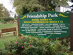
- Friendship Park is an urban park located north of East 14th Street near Reed Street, where a woodchip path and some yellow paint mask the railroad tracks that once led to a coal yard on the property. The signed park, which contains flower gardens and several tall birdhouses to attract song birds, has a smart split-rail fence surrounding the property and a number of park benches from which to enjoy the scene. A community project, the park was developed as part of the US government's Community Capacity Development Office'sCommunity Capacity Development OfficeThe Community Capacity Development Office is an office of the United States Department of Justice and a component of the Office of Justice Programs...
Weed and Seed program.
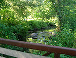
- Frontier Park is one of the more significant of Erie's city parks, with many recreational and educational uses. The park is located on 33 acres (133,546.4 m²) of land along the west side of the Bayfront Parkway between West 6th Street and West 8th Street in northwestern Erie. This community park was developed in 1974.
- Half a dozen fields are available for children's soccer leagues, picnicking, and other activities. Six lit tennis courts and a children's playground are enjoyed along West 6th Street, where off-street parking holds approximately two dozen vehicles. Paved walks make a circuit of the park and include two crossings of the west branch of Cascade Creek. Joggers, bikers, and pedestrians on these paths can explore both flat and hilly terrain, lawn areas and reedy swamps, and a deep woods tree canopy and open spaces. A bike path connects Frontier Park to the Bayfront bikeway. Plans are afoot for an ice rink.
- The Lake Erie Arboretum at Frontier Park (LEAF) was dedicated on 8 September 2001, after four years of local planning, fund raising, and planting. The LEAF program includes over 225 species of trees in an arboretumArboretumAn arboretum in a narrow sense is a collection of trees only. Related collections include a fruticetum , and a viticetum, a collection of vines. More commonly, today, an arboretum is a botanical garden containing living collections of woody plants intended at least partly for scientific study...
, what organizers nickname a tree museum. Dan Dahlkemper, owner of Dahlkemper Landscape Architects and Contractors, was the landscape architect for the project. An amphitheater with four stony rows of seating for approximately 75 persons is embedded in a wooded hillside not far from West 6th Street. The amphitheater is called the Patricia McCain Outdoor Classroom. The Labyrinth at LEAF was added to the park in 2005. (Ward 4)
- Garden Heights Playground is located at East 40th Street and Brewer in the Garden Heights section of the southeast corner of the city. (Ward 5)
- Garden Park is a small park at Sassafras Street and Norman Way, located just east of Glenwood Park and west of State Street at West 35th Street. (Ward 5)
- Glenwood Park is a significant park in Erie. The park is accessible from Glenwood Park Avenue, along both sides of which it meanders north and south between West 30th Street and West Grandview Boulevard in the Glenwood section of the city. West 38th Street crosses the park east and west from a point just east of Cherry Street. The main entrance to the Erie ZooErie ZooThe Erie Zoo , is a zoological park in Erie, Pennsylvania. It is located on of land in Glenwood Park, just off West 38th Street between Cherry Street and Glenwood Park Avenue...
, JMC Ice Arena, and Kuschinski Family Horseshoe Courts is found at Shunpike Road off West 38th Street. The Joseph Martin Golf Club is in the southwest corner of the park. Magyar Park, which was relocated in 2006 to the northwest corner of West 38th Street and Glenwood Park Avenue, contains a monument to the Hungarian Revolution of 1956. (Ward 5)
- Gridley Park is named for Charles Vernon GridleyCharles Vernon GridleyCharles Vernon Gridley was an officer in the United States Navy during the American Civil War and the Spanish-American War.-Early life:...
, who married and had a family while stationed in Erie in the early 1870s. Gridley served with distinction at the Battle of Mobile Bay during the American Civil War, and commanded the US Navy flagship Olympia at the Battle of Manila Bay during the Spanish-American War. A memorial erected by the city in 1913 in his honor stands in the small median running down the center of Liberty Street. The park is two full blocks wide, centered on Liberty Street, with Poplar Street on the east, Plum Street on the west, Park Avenue North on the north, and Park Avenue South on the south. Each block has a central garden hub, with sidewalks radiating out to the corners and lining the park at the street edge. Of particular interest: the plaque on Captain Gridley's memorial is etched on sheet metal recovered from the USS Maine. The park was initially called Cascade Park. (Ward 4)
- Griswold Park was dedicated on December 3, 1927, by Mayor Joseph Crane Williams. The park is located between Sassafras Street on the west, Peach StreetPeach StreetPeach Street, part of U.S. Route 19, is a main artery serving downtown Erie, Pennsylvania. Once surrounded by nothing but rolling hills and farmland, "Upper Peach Street" , is the most significant center of urban sprawl in Erie and is now home to numerous strip plazas, a major shopping mall and...
on the east, West 13th Street on the north, and West 14th Street on the south. The park is situated near Union StationUnion Station (Erie)Union Station is a train station in downtown Erie, Pennsylvania. It opened on December 3, 1927. It is served by Amtrak, the national railroad passenger system, which maintains a small office in the building...
.
- The park is named for Matthew GriswoldMatthew Griswold (congressman)Matthew Griswold was an American Congressman from Erie, Pennsylvania.Matthew Griswold was the grandson of congressman Roger Griswold and the great-grandson of governor Matthew Griswold...
, US Congressman and part owner of Erie's Selden and Griswold Manufacturing Company, famous maker of now-collectible cast iron skillets.
- Griswold Plaza, which is on the northwest corner of the park, was dedicated in 1930 to Griswold's son, Matthew Griswold, Jr, who served as General Manager of the Erie works of the General Electric Company. The son, who headed the dedication of the neighboring park three years earlier, died in the interim and was memorialized by the city.
- The park contains a cast-aluminum marker honoring the famous magician Harry KellarHarry KellarHarry Kellar was an American magician who presented large stage shows during the late 19th and early 20th centuries....
, whose childhood home was situated near the park. The marker, placed by the Pennsylvania Historical and Museum CommissionPennsylvania Historical and Museum CommissionThe Pennsylvania Historical and Museum Commission is the governmental agency of the Commonwealth of Pennsylvania responsible for the collection, conservation and interpretation of Pennsylvania's historic heritage...
and the Erie Art MuseumErie Art MuseumErie Art Museum is an art museum in Erie, Pennsylvania with a collection of over 7,000 objects, including American ceramics, Tibetan paintings, Indian bronzes, contemporary baskets, and many other categories...
, was dedicated on May 9, 2008.
- The Erie Redevelopment Authority plans a $51 million urban renewal project to construct 143 new residential units in the four blocks between State Street, Sassafras Street, West 12th Street, and West 14th Street, including up to fourteen town houses along Peach Street and West 13th Street, which each bisect the area. The one-acre park, a feature of the new neighborhood, will be extended and better lit as a result of the project, which is expected to begin in the summer of 2008. Gardens and water will be added, while a gazebo that has attracted the homeless will be relocated to a different park.
- The park hosted the Erie Farmers' MarketFarmers' marketA farmers' market consists of individual vendors—mostly farmers—who set up booths, tables or stands, outdoors or indoors, to sell produce, meat products, fruits and sometimes prepared foods and beverages...
from its inception in 2004 through the summer of 2007, after which the market was moved to Perry SquarePerry SquarePerry Square is one of the series of city squares planned by famed surveyor Andrew Ellicott in downtown Erie, Pennsylvania, USA. The park diverts the flow of 6th Street for two wooded city blocks bisected by State Street, which separates the city's eastern and western halves...
due to the above construction. Regional farmers pay a one-time fee to sell their produce weekly during the summer months. (Ward 3)
- C. Francis Haggerty Park is a fairly large recreational park located along the eastern side of Route 79, with an entrance off West 32nd Street. It has a baseball field and basketball courts. It was developed by the city in 1973. Mr Haggerty was Erie's City Treasurer in 1969. Lohse Playground is found in this park at West 27th Street and Gerry Avenue. (Ward 6)
- Harborcreek Community Park is a large park located south of Buffalo RoadU.S. Route 20U.S. Route 20 is an east–west United States highway. As the "0" in its route number implies, US 20 is a coast-to-coast route. Spanning , it is the longest road in the United States, and the route sparsely parallels Interstate 90...
in Harborcreek Township. The park, which hosts Harborfest every July, is used extensively by local schools and community groups for year-round sporting and recreation.
- Bobby Harrison Field. (see Rodger Young Park)
- Headwaters Conservation Park is a 35 acres (141,640.1 m²) park located on Wager Road near Interstate 90Interstate 90Interstate 90 is the longest Interstate Highway in the United States at . It is the northernmost coast-to-coast interstate, and parallels US 20 for the most part. Its western terminus is in Seattle, at Edgar Martinez Drive S. near Safeco Field and CenturyLink Field, and its eastern terminus is in...
and Pennsylvania Route 8Pennsylvania Route 8Pennsylvania Route 8 is a major long route in western Pennsylvania. Officially, PA 8 is named the William Flinn Highway. Its southern terminus is at Interstate 376, U.S. Route 22, and U.S. Route 30 in Pittsburgh...
in Millcreek Township. One of two parks owned by Erie County, Headwaters consists of hardwood forest, wetlands, and grasslands at the source of Mill CreekMill Creek (Lake Erie)The Mill Creek is a long tributary of Lake Erie in Erie County in the U.S. state of Pennsylvania. It flows from Millcreek Township through the city of Erie, into Presque Isle Bay....
. The scars of old logging skids and poor farming practices are in evidence. Since the county has no parks department, Headwaters is managed by the Erie County Conservation District. The park is the home of the Headwaters Conservation Park Natural Resource Center, a 10000 square feet (929 m²) facility devoted to interpretation of environmental and conservation related to the Lake Erie WatershedLake Erie Watershed (Pennsylvania)Lake Erie Watershed is a major drainage catchment in northwestern Pennsylvania, consisting of lands with direct runoff and sub-watersheds with waterways that flow into Lake Erie and Presque Isle Bay from Crawford and Erie counties, as well as from New York...
. Seventy-five percent of the funding for the $493,000 resource center, which was dedicated in August 2002, was raised by private donations.
- Hillside Park is a playground established in October 1996. It can be accessed through an entrance along the east side of Old French Road. The park consists of the land between East 39th Street on the north and East Lakeview Boulevard on the south. The park is just west of Mercyhurst CollegeMercyhurst CollegeMercyhurst College is a Catholic liberal arts college in Erie, Pennsylvania, USA.-History:On September 20, 1926, Mercyhurst College opened its doors just a few blocks away from the city's southern boundary. It was founded by the Sisters of Mercy of the Erie Diocese, who were led by Mother M. Borgia...
. One of two baseball fields in this park is named in honor of local Negro League and Major League BaseballMajor League BaseballMajor League Baseball is the highest level of professional baseball in the United States and Canada, consisting of teams that play in the National League and the American League...
player Sam JethroeSam JethroeSamuel Jethroe, nicknamed "The Jet" , was an American center fielder in Negro League and Major League Baseball. With the Cincinnati & Cleveland Buckeyes he won a pair of batting titles, hit .340 over seven seasons from 1942 to 1948, and helped the team to two pennants and the Negro League World...
. (Ward 5)
- Sam Jethroe Field. (see Hillside Park)
- Martin Luther King, Jr. Park is a small park on the north side of West 4th Street near Chestnut Street. It is named for the civil rights activist, Martin Luther King, Jr.Martin Luther King, Jr.Martin Luther King, Jr. was an American clergyman, activist, and prominent leader in the African-American Civil Rights Movement. He is best known for being an iconic figure in the advancement of civil rights in the United States and around the world, using nonviolent methods following the...
.
- Kosciuszko Park is a park located south of East 12th Street between Wayne Street and the Bayfront ConnectorBayfront ConnectorThe Bayfront Connector is a , four-lane expressway that connects Interstate 90 to downtown Erie, Pennsylvania.- Route description :At the intersection of East 12th Street, the Bayfront Parkway becomes the Bayfront Connector and picks up the concurrency with Pennsylvania Route 290...
. The park was named in honor of Tadeusz KościuszkoTadeusz KosciuszkoAndrzej Tadeusz Bonawentura Kościuszko was a Polish–Lithuanian and American general and military leader during the Kościuszko Uprising. He is a national hero of Poland, Lithuania, the United States and Belarus...
. Within the park is Roman Blaszczyk Field, a baseball field developed by the city in 1983. (Ward 2)
- Lake Erie Community Park is located in Lake City, PennsylvaniaLake City, PennsylvaniaLake City is a borough in Erie County, Pennsylvania, United States. The population was 2,811 at the 2000 census. It is part of the Erie Metropolitan Statistical Area.-Geography:Lake City is located at ....
. Access to the park is from Pennsylvania Route 5Pennsylvania Route 5Pennsylvania Route 5 is a westward continuation of New York State Route 5 in Pennsylvania. It runs from North East, Pennsylvania at the New York-Pennsylvania border to near Erie, a total of . The highway is called the Purple Heart Highway and mostly called Lake Road...
, just west of Pennsylvania Route 18Pennsylvania Route 18Pennsylvania Route 18 is a major north–south highway in Western Pennsylvania whose southern terminus is at the West Virginia state line in Greene County, Pennsylvania near the village of Garrison, while the northern terminus is at PA Route 5 in Lake City, Pennsylvania...
.
- Lake Front Drive Park. (see Land Lighthouse Park)
- Lake Park is a small, unmarked grassy margin located in a quiet northeast Erie neighborhood off East 6th Street, along the shoreline of Lake Erie. It is situated between Lake Avenue on the east, Park Way on the west, and may cross Lakeside Drive into some undeveloped woodland that abuts Lake Erie. (Ward 1)
- Lakeside Park is a green space north of West 2nd Street between Peach Street and Sassafras Street.
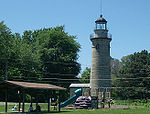
- Land Lighthouse Park is a park along the shoreline of Lake Erie just east of Presque Isle peninsula. The Erie Land LightErie Land LightThe Erie Land Light, also known as the Old Presque Isle Light, is a lighthouse in Erie, Pennsylvania. It is one of the three lighthouses in Erie, along with the Presque Isle Light and the North Pier Light. The lighthouse is located in Lighthouse Park at the end of Lighthouse Street.The lighthouse...
, Lake Front Drive Park, and McCarty Playground are all situated within this same location at the foot of Dunn Boulevard and Lighthouse Road, just off East Lake Road (Alternate Route 5). (Ward 1)
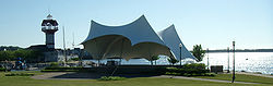
- Liberty Park is a community park located on Pier III, just off the Bayfront Parkway at the shore of Lake Erie. The park contains 8.5 acres (34,398.3 m²) of public access walkways, playgrounds, and sand volleyball courts. The Pepsi Amphitheater hosts a number of popular events within the park. Water taxis provide service to Presque Isle State Park. The park is adjacent to the Bay Harbor Marina.
- William McKinley Park is a park located at East 21st Street and East Avenue. The park, which is associated with the William McKinley Elementary School, contains basketball and tennis courts.
- Nate Levy Park, also known as Nate Levy - Jaycee Park, is a park located at East 2nd Street and Holland Street. The park contains a playground and tennis courts.
- Lohse Playground. (see C. Francis Haggerty Park)
- Magyar Park. (see Glenwood Park)
- McCarty Playground. (see Land Lighthouse Park)
- The land that local street maps and an old wooden sign label as McClelland Park, but is referred to by the City of Erie as Project 70 Site #6, is a large undeveloped city park property located due east of the Erie Industrial Park in eastern Erie. It is situated to the east of McClelland Avenue and to the west of Bird Drive between East 26th Street on the north and East 31st Street on the south. The property was known locally as Old Maids' Hill. Its 56 acres (226,624.2 m²) of land were purchased in the 1960s as thirteen individual parcels for use as a park or playground with approximately $56,000 in grant money from the Project 70 Act. The property is bisected south to north by a shale-bottomed stream known as McDaniel's Run. The southern half of the property is covered in a hardwood forest consisting of oak, cherry, and white birch. The northern portion has low, dense brush with the occasional hardwood sapling and thorn apple as well as the foundations of an abandoned building the origins of which remain unknown. The city has considered bond issues to capitalize development of the park, but no progress has been made to date. Several informal trails pass throughout the park.
- The city was cited in 1990 and again in 1997 for dumping road sweeper waste on the property, in violation of the Project 70 Act, so an ordinance was added to the city code in 1997 prohibiting same. While the city no longer dumps in the park, some city residents use the park margins instead of city services to dispose of yard debris and old Christmas trees.
- 19th and Wayne is a recreational area with basketball courts at East 19th Street and Wayne Street.
- Barbara Nitkiewicz Field is a small park with a grassy lawn, some ornamental trees and a small playground. It is located at West 3rd Street and Cascade Street, just south of where the Bayfront Parkway turns away from the bay. (Ward 4)
- Orush Park is described by the city as being located between West 27 Street and West 29th Street near Harvard Street.. It is presumably adjacent to Larry Fabrizi Park (above), but there are no indications of a park. The local newspaper puts it one block west of Harvard and five blocks long instead of two. The Erie Times-News describes it as "a narrow strip of land between Ellsworth Avenue and Hudson Street from West 27th to West 32nd Streets. It covers a sewer line, and it has largely been taken over by nearby property owners."
- Pebble Lake Playground is on the east side of Washington Avenue at West 26th Street. (Ward 6)
- Pepsi Amphitheater. (see Liberty Park)
- Perry SquarePerry SquarePerry Square is one of the series of city squares planned by famed surveyor Andrew Ellicott in downtown Erie, Pennsylvania, USA. The park diverts the flow of 6th Street for two wooded city blocks bisected by State Street, which separates the city's eastern and western halves...
is a major downtown Erie park centered on State Street, with French Street on the east, Peach Street on the west, Park Row North on the north, and Park Row South on the south. A statue of Oliver Hazard PerryOliver Hazard PerryUnited States Navy Commodore Oliver Hazard Perry was born in South Kingstown, Rhode Island , the son of USN Captain Christopher Raymond Perry and Sarah Wallace Alexander, a direct descendant of William Wallace...
, hero of the War of 1812War of 1812The War of 1812 was a military conflict fought between the forces of the United States of America and those of the British Empire. The Americans declared war in 1812 for several reasons, including trade restrictions because of Britain's ongoing war with France, impressment of American merchant...
, stands in the park. Adjacent to the park are City Hall, the Federal Court House, the Erie County Courthouse, and the Erie History Center. A $358,000 upgrade of the park is scheduled for spring 2008 as part of the city's downtown revitalization program, which is being implemented by the Philadelphia consulting firm Kise Straw and Kolodner. (Wards 1 and 4)
- Presque Isle State ParkPresque Isle State ParkPresque Isle State Park is a Pennsylvania state park on an arching sandy peninsula that juts into Lake Erie, west of the city of Erie, in Millcreek Township, Erie County, Pennsylvania, in the United States. The peninsula sweeps northeastward, surrounding Presque Isle Bay along the park's...
, consisting of most of Presque Isle peninsula, is the largest park in the region. It supports a variety of recreational and educational activities for millions of visitors annually.
- Pulaski Park is a park and playground located north of East 12th Street between Brandes Street and Hess Avenue. It was named in honor of Kazimierz Pułaski, but no sign showing his name is visible. The park contains Jim Brutcher Field and Joseph Wronek Memorial Field, each developed by the city in 1983. Joseph Wronek is described on the park's scoreboard as a sportsman, veteran, and competitor. The park also contains a treed parkland and a playground with swings.(Ward 2)
- Ravine Park is a sizable but undeveloped park forming a wooded ravineRavineA ravine is a landform narrower than a canyon and is often the product of streamcutting erosion. Ravines are typically classified as larger in scale than gullies, although smaller than valleys. A ravine is generally a fluvial slope landform of relatively steep sides, on the order of twenty to...
surrounding Ravine Drive, just off Crescent Drive, in the Kahkwa section of northwest Erie. Ravine Drive, which passes along the bottom of the ravine and provides the only access to the parkland, serves primarily as a beautiful, secluded access road to the Erie Yacht ClubErie Yacht ClubThe Erie Yacht Club, located on the far southwestern shore of Presque Isle Bay in Erie, Pennsylvania, is one of the oldest yacht clubs in America.-History:...
and the numerous private residences at Ferncliff Beach. (Ward 4)
- Reservoir Park is located south of West Grandview Boulevard between Cherry Street and Hillcrest Avenue in the Glenwood section of the city.
- Roessler Park was developed by the city in 1973. It is located between East 15th Street on the north, the railroad tracks on the south, Wayne Street on the east, and Ash Street on the west. (accessible via Ash Street) The park contains a playground, covered picnic area, benches, and a grassy lawn.
- Roma Park is an undeveloped parkland located between Zimmerman Road on the east, Roma Drive on the west, East 31st Street on the north, and East 35th Street on the south. Connell Elementary School, adjacent to the park on E 38th Street, has a large recreational area behind the school. (Ward 5)
- Ruby Schaaf Park is a park located south of West 19th Street on Myrtle Street. It contains a playground and basketball courts. It was formerly known as the Myrtle Street Playground. (Ward 6)
- William L Scott Park is a large park operated by Millcreek Township in its Tracydale North section. It was first developed by Erie County in December 1978 and passed to the control of the local township circa 2005. The park is situated just to the east of the entrance to Presque Isle State Park. The park is named for a prominent gentleman named William Lawrence ScottWilliam Lawrence ScottWilliam Lawrence Scott was a Democratic member of the U.S. House of Representatives from Pennsylvania. His body is buried at Erie Cemetery.-Family:...
, who twice represented Erie to the U.S Congress and twice served as Erie's mayor. The park contains two baseball fields, a small playground, beach volleyball, and a picnic area. The Presque Isle Rotary Club carved out the Bay Trail hiking trail. The north end of the park contains a private BMXBMXBicycle motocross or BMX refers to the sport in which the main goal is extreme racing on bicycles in motocross style on tracks with inline start and expressive obstacles, and it is also the term that refers to the bicycle itself that is designed for dirt and motocross cycling.- History :BMX started...
racingBMX racingBMX racing is a type of off-road bicycle racing. The format of BMX was derived from motocross racing. BMX bicycle races are sprint races on purpose-built off-road single-lap race tracks. The track usually small a starting gate for up to eight racers, a groomed, serpentine, dirt race course made of...
operation. The Sommerheim Park Archaeological DistrictSommerheim Park Archaeological DistrictThe Sommerheim Park Archaeological District includes a group of six archaeological sites west of Erie, Pennsylvania in the United States. The sites are in Sommerheim Park, one of the few undeveloped areas of the Lake Erie shoreline, in Millcreek Township...
is located within the park.
- Shades Beach Park is a lakeside recreational area, beach, and marina north of Lake Road EastPennsylvania Route 5Pennsylvania Route 5 is a westward continuation of New York State Route 5 in Pennsylvania. It runs from North East, Pennsylvania at the New York-Pennsylvania border to near Erie, a total of . The highway is called the Purple Heart Highway and mostly called Lake Road...
in Harborcreek Township. Once part of the Erie County park system, control passed from the county to the township in the late 1990s. Federal, state, and county funding totaling $2.6 million provided a boat launch and other major improvements.
- Six Mile Creek Park is 450 acres (1.8 km²) of undeveloped land surrounding Six-Mile Creek, situated just south of Interstate 90Interstate 90Interstate 90 is the longest Interstate Highway in the United States at . It is the northernmost coast-to-coast interstate, and parallels US 20 for the most part. Its western terminus is in Seattle, at Edgar Martinez Drive S. near Safeco Field and CenturyLink Field, and its eastern terminus is in...
in Harborcreek Township. Purchased from the state by Erie County with Project 70 Land Acquisition and Borrowing ActProject 70 Land Acquisition and Borrowing ActProject 70 Land Acquisition and Borrowing Act is a public lands acquisition law enacted in the Commonwealth of Pennsylvania on 22 June 1964. It permits the state to issue bonds for the purchase of lands for public parks, reservoirs, and other conservation, recreation, and historical preservation...
funds in the late 1960s, the park is the responsibility of the Erie County Department of Planning, which relies on the Erie County Conservation District to oversee the property. With state approval, the county could pass control of the park to Harborcreek, which operates a highly regarded parks department, if obligatory Project 70 public access modification costs can be absorbed by the state.
- South Pier is located at the northern tip of Port Access Road, just off the Bayfront Parkway where it meets the Bayfront ConnectorBayfront ConnectorThe Bayfront Connector is a , four-lane expressway that connects Interstate 90 to downtown Erie, Pennsylvania.- Route description :At the intersection of East 12th Street, the Bayfront Parkway becomes the Bayfront Connector and picks up the concurrency with Pennsylvania Route 290...
. The site offers a view of Presque Isle BayPresque Isle BayPresque Isle Bay is a natural bay located off the coast of Erie, Pennsylvania, United States. Its embayment is about in length, about across at its widest point, and an average depth of about . The bay is bounded on the north and west by a recurved peninsula that makes up Presque Isle State Park...
, Lake Erie, and the channel between them; Presque Isle State Park, the US Coast Guard Station, and Perry Monument. Parking and picnic facilities are available. The Captain John E. Lampe Marina is a close walk. A paved walkway runs along the wooded eastern side of Port Access Road.
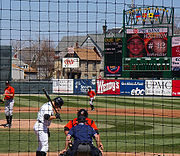
- Jerry Uht ParkJerry Uht ParkJerry Uht Park is a 6,952-seat baseball-only stadium in Erie, Pennsylvania that hosted its first regular season baseball game on June 20, 1995, as the tenants of the facility, the Erie SeaWolves, defeated the Jamestown Jammers....
is a baseball stadium where the Erie SeawolvesErie SeaWolvesThe Erie SeaWolves are a minor league baseball team based in Erie, Pennsylvania. The team, which plays in the Eastern League, is the Double-A affiliate of the Detroit Tigers Major League Baseball club....
minor league baseball team plays.
- Viaduct Playground is located at East 17th Street and Franklin Street, between Buffalo Road and the railroad tracks. (Ward 2)
- Victory Park is a small park just south of West 12th Street at the Interstate 79 interchange. (Ward 3) (see Agresti Baseball Field at Victory Playground)
- Joseph A Walczak, Sr. Park was developed by the city in 1974. It is located at the end of Alan Drive South off of Zimmerman Road in the North View section of southeastern Erie. Mr. Walczak was president of the city council in 1969. The park contains a baseball field with bleechers and dugouts, a playground, basketball courts, and a covered picnic area. (Ward 5)
- Wallace Playground is located just south of the Bayfront Parkway at Front Street and Wallace. It contains a playground, as well as soccer and softball facilities. The field is called the Ted Amendola Memorial Field. (Ward 1)
- Washington Park is a park located between Raspberry Street and Cascade Street and 23rd Street and 24th Street. (Ward 6)
- Wayne Park is located in northeastern Erie. It is named for Anthony WayneAnthony WayneAnthony Wayne was a United States Army general and statesman. Wayne adopted a military career at the outset of the American Revolutionary War, where his military exploits and fiery personality quickly earned him a promotion to the rank of brigadier general and the sobriquet of Mad Anthony.-Early...
, a general in the American Revolution. (Ward 1)
- West Grandview Park is located in Erie Heights in the southwest corner of the city, just east of Interstate 79Interstate 79Interstate 79 is an Interstate Highway in the eastern United States, designated from Interstate 77 in Charleston, West Virginia to Pennsylvania Route 5 and Pennsylvania Route 290 in Erie, Pennsylvania...
. The headquarters of the Lord CorporationLord CorporationLORD Corporation is a privately held company that designs, manufactures and markets devices and systems to manage mechanical motion and control noise and vibration. The company formulates, produces and sells general purpose and specialty adhesives and coatings; and develops products and systems...
are situated adjacent to the park.
- Woodland Park is an undeveloped wooded park in the Woodland Park section of northwestern Erie. The park is situated along Grove Street between Delaware and Lincoln, just north of the junction of Interstate 79 and West 12th Street. (Ward 3)
- Woodlawn Park is a small park located at West 32nd Street and Harvard Street.
- Joseph Wronek Memorial Field. (see Pulaski Park)
- Rodger Young Park is an unmarked park located on both sides of Downing Avenue between Buffalo Road and the railroad tracks. This expansive park contains Bobby Harrison Field, a football/soccer field with stadium seating which was developed by the city in 2005.
- Zuck Park is located on the east side of Zuck Drive and north of West Grandview Blvd in Millcreek Township. The park was deeded to Millcreek Township in 1988 by the city, which had closed the park due to liability insurance costs. Millcreek reopened the park in March 1989 after $14,000 in renovations.
See also
- Parks Laid Out With Original Plans of City Make Erie Beautiful, Erie Dispatch, 31 December 1911
- Sure Sign of Winter, Erie Times, 20 August 1932
- City Proud of Parks, Erie Dispatch, 17 March 1935
- Quiet, Restful Zuck Park Monument to Two Men, ----, 4 March 1938
- Glenwood's Bridge Has Double Use, Erie Times, 31 August 1946
- Beautiful Parks For All to Enjoy, Erie Times News, 24 June 1973
External links
- Erie City Parks and Recreation Bureau is part of Erie's Public Works Department.
- 2009 City of Erie Summer Parks and Recreation Program
- For further information about Erie parks, check out the Keystone Active Zone(KAZ) website.
- Local city ordinances Article 955.02 gives a roster of park and playground area designations and locations Codified Ordinances of Erie, Part 9, orig. pp. 73–77 (pdf pp. 161–165)