

List of cities, towns and villages in the Solomon Islands
Encyclopedia
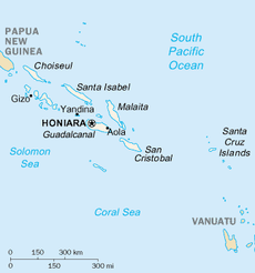
This is a list of cities, towns and villages in the Solomon Islands
.

Solomon Islands
Solomon Islands is a sovereign state in Oceania, east of Papua New Guinea, consisting of nearly one thousand islands. It covers a land mass of . The capital, Honiara, is located on the island of Guadalcanal...
.
| City, town or village | Coordinates Geographic coordinate system A geographic coordinate system is a coordinate system that enables every location on the Earth to be specified by a set of numbers. The coordinates are often chosen such that one of the numbers represent vertical position, and two or three of the numbers represent horizontal position... | |Island | Province Provinces of the Solomon Islands Solomon Islands is currently divided into 9 provinces. The national capital, Honiara, on the island of Guadalcanal, is separately governed as Capital Territory.-History:... |
|
|---|---|---|---|---|
| Auki Auki Auki is the provincial capital of Malaita Province, Solomon Islands. It is situated on the northern end of Langalanga Lagoon on the north-west coast of Malaita Island. There are daily flights between the Solomons capital of Honiara and Auki... |
8.76°N 160.70°W | Malaita Malaita Malaita is the largest island of the Malaita Province in the Solomon Islands. A tropical and mountainous island, Malaita's pristine river systems and tropical forests have not been exploited. Malaita is the most populous island of the Solomon Islands, with 140,000 people or more than a third of the... |
Malaita Province Malaita Province Malaita Province is one of the largest provinces of the Solomon Islands. It is named for its largest island, Malaita . Other islands include South Malaita Island , Sikaiana Island, and Ontong Java Atoll. The provincial capital and largest urban center is Auki, located on Big Malaita... |
|
| Buala Buala Buala is a town in the Solomon Islands.Buala is located on Santa Isabel Island . Buala consists of Jejevo station and Buala Village. Buala is located on a side of a hill so there is no place for the town to expand, therefore there is still no road in that township. Kubolota, Tithiro, and Maglau are... |
8.16°N 159.62°W | Santa Isabel Island Santa Isabel Island Santa Isabel Island is the longest in the Solomon Islands, South Pacific, and the largest in the group of islands in Isabel Province.-Location and geographic data:... |
Isabel Province Isabel Province Isabel Province is one of the provinces of the Solomon Islands. It has a population of around 30,000 . The capital is Buala on Santa Isabel Island.Santa Isabel is the longest Island in the Solomon Islands, South Pacific... |
|
| Gizo (Ghizo) | 8.10°N 156.85°W | Ghizo Island Ghizo Island Ghizo Island, home to Gizo the capital of the Western Province, Solomon Islands. The island is named after an infamous local head-hunter. It is located west of New Georgia and Kolombangara.... |
Western Province Western Province (Solomon Islands) Western Province is the largest of the provinces of the Solomon Islands. The area is renowned for its beautiful tropical islands, excellent diving and snorkelling, coral reefs and WWII wrecks, ecotourism lodges, and head-hunting shrines... |
|
| Honiara Honiara Honiara, population 49,107 , 78,190 , is the capital of the Solomon Islands and of Guadalcanal Province, although it is a separately administered town... |
9.43°N 159.91°W | Guadalcanal Guadalcanal Guadalcanal is a tropical island in the South-Western Pacific. The largest island in the Solomons, it was discovered by the Spanish expedition of Alvaro de Mendaña in 1568... |
Guadalcanal Province Guadalcanal Province Guadalcanal Province is one of the provinces of the Solomon Islands, consisting of the island of Guadalcanal. It is a 2,510 square mile island and is largely a jungle. Its name was given by Pedro de Ortega Valencia, born in the village of Guadalcanal in Seville, Spain... |
|
| Kirakira Kirakira Kirakira the provincial capital of the Makira-Ulawa Province in the Solomon Islands. Kirakira is located on the north coast of Makira , the largest island of the province. It has roads running east to the Warihito River and west to Maro'u Bay.The Kirakira Airport is served by Solomon Airlines,... (Kaokaona) |
10.44°N 161.88°W | Makira Makira The island of Makira is the largest island of Makira-Ulawa Province in the Solomon Islands. The island is located east of Guadalcanal and south of Malaita. The largest and capital city is Kirakira.... (San Cristobal) |
Makira-Ulawa Province Makira-Ulawa Province Makira-Ulawa Province is one of the provinces of the Solomon Islands. The main part of the province is Makira Island. It has a population of 31,006... |
|
| Lata Lata, Solomon Islands Lata is the provincial capital of Temotu Province, Solomon Islands. As of 2007, it has 553 inhabitants. There are a few rest houses for over night stays. There is a Post office, Telecom office and numerous stores.... (Santa Cruz) |
10.71°N 165.83°W | n/a | Nendo Island Nendo Island Nendo is the largest and most important of the Santa Cruz Islands, located in the Temotu province of the Solomon Islands. The island is also known as Santa Cruz, Ndeni, Nitendi or Ndende... |
Temotu Province Temotu Province Temotu is the easternmost province of the Solomon Islands. The province was formerly known as Santa Cruz Islands Province. It consists, essentially, of two chains of islands which run parallel to each other from the northwest to the southeast.- Islands :... |
| Munda Munda (Solomon Islands) Munda is the largest settlement on the island of New Georgia in the Western Province of the Solomon Islands, and consists of a number of villages... |
8.33°N 157.27°W | n/a | New Georgia New Georgia New Georgia is the largest island of the Western Province of the Solomon Islands.-Geography:This island is located in the New Georgia Group, an archipelago including most of the other larger islands in the province... |
Western Province Western Province (Solomon Islands) Western Province is the largest of the provinces of the Solomon Islands. The area is renowned for its beautiful tropical islands, excellent diving and snorkelling, coral reefs and WWII wrecks, ecotourism lodges, and head-hunting shrines... |
| Noro | 8.22°N 157.22°W | New Georgia New Georgia New Georgia is the largest island of the Western Province of the Solomon Islands.-Geography:This island is located in the New Georgia Group, an archipelago including most of the other larger islands in the province... |
Western Province Western Province (Solomon Islands) Western Province is the largest of the provinces of the Solomon Islands. The area is renowned for its beautiful tropical islands, excellent diving and snorkelling, coral reefs and WWII wrecks, ecotourism lodges, and head-hunting shrines... |
|
| Taro Island Taro Island Taro Island is a small island in the Solomon Islands with 507 inhabitants, capital of Choiseul Province and is located in Choiseul Bay off the northwest coast.... |
6.72°N 156.43°W | Taro Island Taro Island Taro Island is a small island in the Solomon Islands with 507 inhabitants, capital of Choiseul Province and is located in Choiseul Bay off the northwest coast.... |
Choiseul Province Choiseul Province The Choiseul Province is one of the nine provinces of the Solomon Islands. It lies between the island of Bougainville and Santa Isabel in the west of the Solomon Islands.... |
|
| Tigoa Tigoa Tigoa is a village in the Solomon Islands, on Rennell Island. It is the capital of Rennell and Bellona province. It is located approximately 40–60 ft above sea level.... (Tinggoa) |
11.54°N 160.03°W | n/a | Rennell Island Rennell Island Rennell Island, locally known as Mungava, is the main island of two inhabited islands that make up the Rennell and Bellona Province in the Solomon Islands. Rennell Island has a land area of that is about long and wide. It is the second largest raised coral atoll in the world with the largest lake... (Mungava) |
Rennell and Bellona Province |
| Tulagi Tulagi Tulagi, less commonly Tulaghi, is a small island in the Solomon Islands, just off the south coast of Florida Island. The town of the same name on the island Tulagi, less commonly Tulaghi, is a small island (5.5 km by 1 km) in the Solomon Islands, just off the south coast of Florida... (Tulaghi) |
9.09°N 160.15°W | Tulagi Tulagi Tulagi, less commonly Tulaghi, is a small island in the Solomon Islands, just off the south coast of Florida Island. The town of the same name on the island Tulagi, less commonly Tulaghi, is a small island (5.5 km by 1 km) in the Solomon Islands, just off the south coast of Florida... |
Central Province Central Province (Solomon Islands) The Central Province is one of the provinces of the Solomon Islands, covering the Russell Islands, Nggela Islands and Savo Island. Its area comprises 615 km² and had a population of 21,577 as of 1999. The capital is Tulagi.-Islands:*Aeaun... |