

List of bridges on the National Register of Historic Places in Montana
Encyclopedia
This is a list of bridge
s and tunnel
s on the National Register of Historic Places
in the U.S. state
of Montana
.
Bridge
A bridge is a structure built to span physical obstacles such as a body of water, valley, or road, for the purpose of providing passage over the obstacle...
s and tunnel
Tunnel
A tunnel is an underground passageway, completely enclosed except for openings for egress, commonly at each end.A tunnel may be for foot or vehicular road traffic, for rail traffic, or for a canal. Some tunnels are aqueducts to supply water for consumption or for hydroelectric stations or are sewers...
s on the National Register of Historic Places
National Register of Historic Places
The National Register of Historic Places is the United States government's official list of districts, sites, buildings, structures, and objects deemed worthy of preservation...
in the U.S. state
U.S. state
A U.S. state is any one of the 50 federated states of the United States of America that share sovereignty with the federal government. Because of this shared sovereignty, an American is a citizen both of the federal entity and of his or her state of domicile. Four states use the official title of...
of Montana
Montana
Montana is a state in the Western United States. The western third of Montana contains numerous mountain ranges. Smaller, "island ranges" are found in the central third of the state, for a total of 77 named ranges of the Rocky Mountains. This geographical fact is reflected in the state's name,...
.
| Name | Image | Built | Listed | Location | County | Type |
|---|---|---|---|---|---|---|
| Bad Route Creek Bridge | 2011-4-28 | Fallon vicinity Fallon, Montana As of the census of 2000, there were 138 people, 63 households, and 36 families residing in the CDP. The population density was 27.2 people per square mile . There were 95 housing units at an average density of 18.7 per square mile... 46°58′24"N 105°8′0"W |
Dawson Dawson County, Montana -Economy:Dawson County is known for its dryland grain, coal mines and gas and oil wells. There are 522 current farms and ranches, and 296 commercial businesses.-Demographics:... |
Reinforced Concrete Bridges in Montana, 1900-1958 MPS | ||
| Bell Street Bridge | 1926 | 1988-02-03 | Glendive Glendive, Montana Glendive is a city in and the county seat of Dawson County, Montana, United States. The population was 4,935 at the 2010 census.The town of Glendive is located in South Eastern Montana and is considered by many as an agricultural hub of Eastern Montana... 47°6′20"N 104°43′9"W |
Dawson Dawson County, Montana -Economy:Dawson County is known for its dryland grain, coal mines and gas and oil wells. There are 522 current farms and ranches, and 296 commercial businesses.-Demographics:... |
Warren through trusses | |
| Big Horn River Bridge | 2010-01-04 | Custer Custer, Montana Custer is a census-designated place in Yellowstone County, Montana, United States. The population was 145 at the 2000 census.This community bears the name of U.S... |
Treasure Treasure County, Montana - Demographics :As of the census of 2000, there were 861 people, 357 households, and 242 families residing in the county. The population density was - Demographics :... |
|||
| Bluewater Creek Bridge | 2011-4-28 | Fromberg vicinity Fromberg, Montana Fromberg is a town in Carbon County, Montana, United States. It is part of the Billings, Montana Metropolitan Statistical Area. The population was 486 at the 2000 census.-Geography:Fromberg is located at .... 45°22′10"N 108°52′56"W |
Carbon Carbon County, Montana -National protected areas:* Bighorn Canyon National Recreation Area * Custer National Forest * Gallatin National Forest -Economy:During the early history of Carbon County, coal mining was the predominant industry... |
Reinforced Concrete Bridges in Montana, 1900-1958 MPS | ||
| Browne's Bridge | 2010-01-04 | Glen Glen, Montana Glen is an unincorporated community in Beaverhead County, Montana, United States. Although Glen is unincorporated, it has a post office with a ZIP code of 59732. Glen lies on U.S. Route 91 south of Melrose and north of Dillon.-References:... |
Beaverhead Beaverhead County, Montana -National protected areas:* Beaverhead National Forest * Big Hole National Battlefield* Nez Perce National Historical Park * Red Rock Lakes National Wildlife Refuge-History:... |
|||
| Carbella Bridge | 2010-01-04 | Gardiner Gardiner, Montana Gardiner is a census-designated place in Park County, Montana, United States, along the 45th parallel. The population was 851 at the 2000 census.... 45°12′16.25"N 110°54′5.61"W |
Park Park County, Montana Park Counties in Montana and Wyoming are among the very few pairs of counties in the United States with the same name to border each other across state lines.-National protected areas:* Custer National Forest * Gallatin National Forest... |
|||
| Carter Bridge | 2011-4-28 | Livingston vicinity Livingston, Montana -Geography:Livingston is located at , at an altitude of 4.501 feet .According to the United States Census Bureau, the city has a total area of , of which, of it is land and 0.38% is waters.-Climate:-Demographics:... 45°35′49"N 110°34′2"W |
Park Park County, Montana Park Counties in Montana and Wyoming are among the very few pairs of counties in the United States with the same name to border each other across state lines.-National protected areas:* Custer National Forest * Gallatin National Forest... |
Reinforced Concrete Bridges in Montana, 1900-1958 MPS | ||
| Conley Street Bridge | 2011-4-28 | Deer Lodge Deer Lodge, Montana Deer Lodge is a city in and the county seat of Powell County, Montana, United States. The population was 3,421 at the 2000 census. The city is perhaps best known as the home of the Montana State Prison, a major local employer... 46°23′26"N 112°44′14"W |
Powell Powell County, Montana -National protected areas:* Beaverhead-Deerlodge National Forest * Flathead National Forest * Grant-Kohrs Ranch National Historic Site* Helena National Forest * Lolo National Forest * Bob Marshall Wilderness Area... |
Reinforced Concrete Bridges in Montana, 1900-1958 MPS | ||
| Hardy Bridge | 2010-01-04 | Cascade Cascade, Montana Cascade is a town in Cascade County, Montana, United States. The population was 819 at the 2000 census. It is part of the 'Great Falls, Montana Metropolitan Statistical Area'.-Geography:... |
Cascade Cascade County, Montana -National protected areas:*Benton Lake National Wildlife Refuge*Lewis and Clark National Forest -Economy:Malmstrom Air Force Base is a driving force in the regional economy... |
|||
| Dearborn River High Bridge | 1897 | 2003-12-18 | Augusta Augusta, Montana Augusta is a census-designated place in Lewis and Clark County, Montana, United States. The population was 284 at the 2000 census. It is named after the daughter of D. J... 47°16′52"N 112°23′25"W |
Lewis and Clark Lewis and Clark County, Montana -National protected areas:* Flathead National Forest * Helena National Forest * Lewis and Clark National Forest * Lolo National Forest * Rocky Mountain Front Conservation Area -Demographics:... |
Pratt half-deck truss | |
| Flathead Bridge | 2010-7-17 | Columbia Falls vicinity Columbia Falls, Montana Columbia Falls is a city in Flathead County, Montana, United States. The population was 3,645 at the 2000 census.-Geography:Columbia Falls is located at .... |
Flathead Flathead County, Montana -National protected areas:* Pacific Northwest National Scenic Trail * Flathead National Forest * Glacier National Park * Kootenai National Forest * Lolo National Forest * Lost Trail National Wildlife Refuge-Demographics:... |
|||
| Forsyth Bridge | 1905, 1939 | 1990-02-12 | Forsyth Forsyth, Montana Forsyth is a city in and the county seat of Rosebud County, Montana, United States. The population was 1,944 at the 2000 census. Forsyth was established in 1876 as the first settlement on the Yellowstone River, and in 1882 residents named the town after General James William Forsyth who commanded... 46°15′57"N 106°41′31"W |
Rosebud Rosebud County, Montana -Demographics:As of the census of 2000, there were 9,383 people, 3,307 households, and 2,417 families residing in the county. The population density was 2 people per square mile . There were 3,912 housing units at an average density of 1 per square mile... |
Pennsylvania truss bridge | |
| Fort Benton Bridge | 1888 | 1980-08-06 | Fort Benton Fort Benton, Montana Fort Benton is a city in and the county seat of Chouteau County, Montana, United States. A portion of the city was designated as a National Historic Landmark District in 1961. Established a full generation beforethe U.S... 47°49′2"N 110°39′38"W |
Chouteau Chouteau County, Montana -National protected areas:* Lewis and Clark National Forest * Upper Missouri River Breaks National Monument -Economy:Chouteau County is the largest winter wheat producer for the state of Montana... |
||
| Fromberg Concrete Arch Bridge | 1914 | 1993-01-28 | Fromberg Fromberg, Montana Fromberg is a town in Carbon County, Montana, United States. It is part of the Billings, Montana Metropolitan Statistical Area. The population was 486 at the 2000 census.-Geography:Fromberg is located at .... 45°23′31"N 108°53′39"W |
Carbon Carbon County, Montana -National protected areas:* Bighorn Canyon National Recreation Area * Custer National Forest * Gallatin National Forest -Economy:During the early history of Carbon County, coal mining was the predominant industry... |
Concrete arch bridge | |
| Hutchins Bridge | 1902 | 1999-03-18 | Cameron Cameron, Montana Cameron in an unincorporated community in Madison County, Montana, United States.It was named for its early settlers, the Cameron family. The first post office was established between 1890-93 in the home of Addison Bovey Cameron. He and his brother Josie had a store and the post office on the... 44°53′20"N 111°34′47"W |
Madison Madison County, Montana -National protected areas:*Beaverhead National Forest *Deerlodge National Forest *Gallatin National Forest -Demographics:As of the census of 2000, there were 6,851 people, 2,956 households, and 1,921 families residing in the county. The population density was 2 people per square mile... |
Pratt Through Truss | |
| Joliet Bridge | 1901 | 1986-05-02 | Joliet Joliet, Montana Joliet is a town in Carbon County, Montana, United States. It is part of the Billings, Montana Metropolitan Statistical Area. The population was 575 at the 2000 census.-Geography:Joliet is located at .-Notable residents:... 45°29′14"N 108°58′32"W |
Carbon Carbon County, Montana -National protected areas:* Bighorn Canyon National Recreation Area * Custer National Forest * Gallatin National Forest -Economy:During the early history of Carbon County, coal mining was the predominant industry... |
Pratt through truss | |
| Kearney Rapids Bridge | 1911, 1931 | 1994-07-22 | Bigfork Bigfork, Montana Bigfork is a census-designated place in Flathead County, Montana, United States. The population was 1,421 at the 2000 census.-Geography:Bigfork is located at .... |
Flathead Flathead County, Montana -National protected areas:* Pacific Northwest National Scenic Trail * Flathead National Forest * Glacier National Park * Kootenai National Forest * Lolo National Forest * Lost Trail National Wildlife Refuge-Demographics:... |
Pratt through truss | |
| Lewis and Clark Bridge Lewis and Clark Bridge (Wolf Point, Montana) The Lewis and Clark Bridge at Wolf Point, Montana spans the Missouri River between McCone and Roosevelt counties. It is also known as Wolf Point Bridge, Missouri River Bridge, or Site No. 24RV438. It was listed on the National Register of Historic Places in 1997.... |
1930 | 1997-11-24 | Wolf Point Wolf Point, Montana Wolf Point is a city in and the county seat of Roosevelt County, Montana, United States. The population was 2,621 at the 2010 census. It is the largest community on the Fort Peck Indian Reservation. Wolf Point is the home of the annual Wild Horse Stampede, held every year during the second weekend... 48°4′2"N 105°32′6"W |
McCone McCone County, Montana -Demographics:As of the census of 2000, there were 1,977 people, 810 households, and 596 families residing in the county. The population density was 1 people per square mile . There were 1,087 housing units at an average density of 0 per square mile... |
Pennsylvania Through Truss | |
| Little Blackfoot River Bridge | 2010-01-04 | Avon Avon, Montana Avon is a census-designated place in Powell County, Montana, United States. The population was 124 at the 2000 census.-Geography:Avon is located at .... |
Powell Powell County, Montana -National protected areas:* Beaverhead-Deerlodge National Forest * Flathead National Forest * Grant-Kohrs Ranch National Historic Site* Helena National Forest * Lolo National Forest * Bob Marshall Wilderness Area... |
|||
| Missouri River Bridge | 2010-01-04 | Wolf Creek Wolf Creek, Montana Wolf Creek is an unincorporated community in Lewis and Clark County, Montana, United States. Wolf Creek is located along Interstate 15 north of Helena. Wolf Creek has a post office with ZIP code 59648.- In popular culture :... |
Lewis and Clark Lewis and Clark County, Montana -National protected areas:* Flathead National Forest * Helena National Forest * Lewis and Clark National Forest * Lolo National Forest * Rocky Mountain Front Conservation Area -Demographics:... |
|||
| Morel Bridge | 1914, 1959 | 2000-12-12 | Anaconda Anaconda, Montana Anaconda, county seat of Anaconda City/Deer Lodge County, is located in mountainous southwestern Montana. The Continental Divide passes within 8 miles of the community with the local Pintler Mountain range reaching 10,379 feet... 46°9′28"N 112°46′16"W |
Deer Lodge Deer Lodge County, Montana -National protected areas:*Beaverhead National Forest *Deerlodge National Forest -Demographics:As of the census of 2000, there were 9,417 people, 3,995 households, and 2,524 families residing in the county. The population density was 13 people per square mile . There were 4,958 housing units at an... |
Rainbow Arch Bridge | |
| Natural Pier Bridge | 2010-01-04 | Alberton Alberton, Montana Alberton is a town in Mineral County, Montana, United States. The population was 374 at the 2000 census. It was named for Albert J. Earling, president of the Chicago, Milwaukee, St. Paul and Pacific Railroad. Alberton was the location of a major chlorine chemical release in 1996... |
Mineral Mineral County, Montana -Demographics:As of the census of 2000, there were 3,884 people, 1,584 households, and 1,067 families residing in the county. The population density was 3 people per square mile . There were 1,961 housing units at an average density of 2 per square mile... |
|||
| Powder River Bridge | 2010-01-04 | Terry Terry, Montana -Demographics:As of the census of 2000, there were 611 people, 294 households, and 171 families residing in the town. The population density was 866.2 people per square mile . There were 387 housing units at an average density of 548.7 per square mile... |
Prairie Prairie County, Montana -Demographics:As of the census of 2000, there were 1,199 people, 537 households, and 354 families residing in the county. The population density was -Demographics:... |
|||
| Ptarmigan Tunnel Ptarmigan Tunnel The Ptarmigan Tunnel was built in 1930 through the Ptarmigan Wall at an elevation of in Glacier National Park, near Many Glacier. The tunnel allows hikers to avoid a strenuous climb over very steep terrain between Many Glacier and the Belly River valley... |
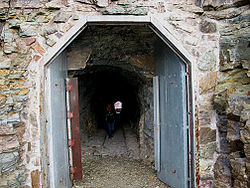 |
1930 | 1986-02-14 | West Glacier West Glacier, Montana West Glacier is a small unincorporated community in eastern Flathead County, Montana, United States. The town is at the west entrance to Glacier National Park and is located on U.S. Route 2 and a main line of the BNSF Railway. The headquarters complex for Glacier National Park is located nearby... 48°51′13"N 113°42′24"W |
Flathead Flathead County, Montana -National protected areas:* Pacific Northwest National Scenic Trail * Flathead National Forest * Glacier National Park * Kootenai National Forest * Lolo National Forest * Lost Trail National Wildlife Refuge-Demographics:... |
|
| Scenic Bridge | 2010-01-04 | Tarkio Tarkio, Montana Tarkio is a place in Montana, located in Mineral County.Tarkio falls in Mountain Time Zone and observes daylight saving time.Tarkio's elevation is 2,940 feet above sea level.Tarkio is approximately 40 miles outside of Missoula, MT.... |
Mineral Mineral County, Montana -Demographics:As of the census of 2000, there were 3,884 people, 1,584 households, and 1,067 families residing in the county. The population density was 3 people per square mile . There were 1,961 housing units at an average density of 2 per square mile... |
|||
| Sheep Creek Bridge | 2011-4-28 | Wolf Creek vicinity Wolf Creek, Montana Wolf Creek is an unincorporated community in Lewis and Clark County, Montana, United States. Wolf Creek is located along Interstate 15 north of Helena. Wolf Creek has a post office with ZIP code 59648.- In popular culture :... 46°58′39"N 112°4′53"W |
Lewis and Clark Lewis and Clark County, Montana -National protected areas:* Flathead National Forest * Helena National Forest * Lewis and Clark National Forest * Lolo National Forest * Rocky Mountain Front Conservation Area -Demographics:... |
Reinforced Concrete Bridges in Montana, 1900-1958 MPS | ||
| Tenth Street Bridge Tenth Street Bridge (Great Falls, Montana) The Tenth Street Bridge is a concrete arch bridge in Great Falls, Montana, spanning the Missouri River. The bridge was designed by engineer Ralph Adams of Spokane, Washington and Great Falls architect George Shanley, and was completed in 1920... |
1920 | 1996-04-25 | Great Falls Great Falls, Montana Great Falls is a city in and the county seat of Cascade County, Montana, United States. The population was 58,505 at the 2010 census. It is the principal city of the Great Falls, Montana Metropolitan Statistical Area, which encompasses all of Cascade County... 47°31′7"N 111°17′22"W |
Cascade Cascade County, Montana -National protected areas:*Benton Lake National Wildlife Refuge*Lewis and Clark National Forest -Economy:Malmstrom Air Force Base is a driving force in the regional economy... |
open spandrel bridge | |
| Theodore Roosevelt Memorial Bridge | 1912 | 2006-12-27 | Troy Troy, Montana Troy is a city in Lincoln County, Montana, United States. The population was 957 at the 2000 census.-Geography:Troy is located at .... 48°28′12"N 115°53′11"W |
Lincoln Lincoln County, Montana -National protected areas:* Pacific Northwest National Scenic Trail *Flathead National Forest *Kaniksu National Forest *Kootenai National Forest -Demographics:... |
Parker-through truss | |
| Toston Bridge Toston Bridge The Toston Bridge is a National Registered Historic Place spanning the Missouri River, on an abandoned segment of old U.S. Route 287, at Toston, Montana. It was added to the Register on July 20, 2005.The placard reads:... |
1919, 1920 | 2005-07-20 | Toston Toston, Montana Toston is a census-designated place in Broadwater County, Montana, United States. The population was 105 at the 2000 census.-Geography:Toston is located at .... 46°10′19"N 111°26′34"W |
Broadwater Broadwater County, Montana -Economy:Agriculture is one of the primary industries in Broadwater County. RY Timber and Wheat Montana Bakery were the largest private employers according to the 2000 Census.-Demographics:... |
Warren through truss | |
| Williams Street Bridge | 1894, 1895 | 2006-11-29 | Helena Helena, Montana Helena is the capital city of the U.S. state of Montana and the county seat of Lewis and Clark County. The 2010 census put the population at 28,180. The local daily newspaper is the Independent Record. The Helena Brewers minor league baseball and Helena Bighorns minor league hockey team call the... 46°36′19"N 112°5′14"W |
Lewis and Clark Lewis and Clark County, Montana -National protected areas:* Flathead National Forest * Helena National Forest * Lewis and Clark National Forest * Lolo National Forest * Rocky Mountain Front Conservation Area -Demographics:... |
Pratt Pony truss | |
| Yellowstone River Bridge | 2010-01-04 | Fallon Fallon, Montana As of the census of 2000, there were 138 people, 63 households, and 36 families residing in the CDP. The population density was 27.2 people per square mile . There were 95 housing units at an average density of 18.7 per square mile... |
LePrairie Prairie County, Montana -Demographics:As of the census of 2000, there were 1,199 people, 537 households, and 354 families residing in the county. The population density was -Demographics:... |