

List of bridges on the National Register of Historic Places in Kentucky
Encyclopedia
This is a list of bridge
s and tunnel
s on the National Register of Historic Places
in the U.S. state
of Kentucky
.
Bridge
A bridge is a structure built to span physical obstacles such as a body of water, valley, or road, for the purpose of providing passage over the obstacle...
s and tunnel
Tunnel
A tunnel is an underground passageway, completely enclosed except for openings for egress, commonly at each end.A tunnel may be for foot or vehicular road traffic, for rail traffic, or for a canal. Some tunnels are aqueducts to supply water for consumption or for hydroelectric stations or are sewers...
s on the National Register of Historic Places
National Register of Historic Places
The National Register of Historic Places is the United States government's official list of districts, sites, buildings, structures, and objects deemed worthy of preservation...
in the U.S. state
U.S. state
A U.S. state is any one of the 50 federated states of the United States of America that share sovereignty with the federal government. Because of this shared sovereignty, an American is a citizen both of the federal entity and of his or her state of domicile. Four states use the official title of...
of Kentucky
Kentucky
The Commonwealth of Kentucky is a state located in the East Central United States of America. As classified by the United States Census Bureau, Kentucky is a Southern state, more specifically in the East South Central region. Kentucky is one of four U.S. states constituted as a commonwealth...
.
| Name | Image | Built | Listed | Location | County | Type | |
|---|---|---|---|---|---|---|---|
| Barren River L & N Railroad Bridge | 1980-11-26 | Bowling Green Bowling Green, Kentucky Bowling Green is the third-most populous city in the state of Kentucky after Louisville and Lexington, with a population of 58,067 as of the 2010 Census. It is the county seat of Warren County and the principal city of the Bowling Green, Kentucky Metropolitan Statistical Area with an estimated 2009... 37°0′10"N 86°25′56"W |
Warren Warren County, Kentucky Warren County is a county located in the U.S. state of Kentucky, specifically the Pennyroyal Plateau and Western Coal Fields regions. It is included in the Bowling Green, Kentucky, Metropolitan Statistical Area. The population was 113,792 in the 2010 Census. The county seat is Bowling Green... |
Camelback | |||
| Beech Fork Bridge, Mackville Road | 1884 | 1989-02-10 | Springfield Springfield, Kentucky Springfield is a city in and county seat of Washington County, Kentucky, United States. The population was 2,634 at the 2000 census. It was established in 1793 and probably named for springs in the area.-Geography:... 37°42′15"N 85°8′46"W |
Washington Washington County, Kentucky Washington County is a county located in the U.S. state of Kentucky. As of 2000, the population was 10,916. Its county seat is Springfield. The county is named for George Washington. Washington County was the first county formed in the Commonwealth of Kentucky when it reached statehood... |
Pratt thru truss | ||
| Bennett's Mill Covered Bridge | 1976-03-26 | Greenup Greenup, Kentucky Greenup is a city in Greenup County, Kentucky, at the confluence of the Ohio and Little Sandy Rivers. The population was 1,198 at the 2000 census. It is the county seat of Greenup County. Greenup is named in honor of Christopher Greenup.... 38°37′50"N 82°55′37"W |
Greenup Greenup County, Kentucky Greenup County is a county located in the U.S. state of Kentucky. It was formed in 1804. As of 2000, the population was 36,891. Its county seat is Greenup. The county is named in honor of Christopher Greenup.... |
||||
| Cabin Creek Covered Bridge | 1976-03-26 | Tollesboro Tollesboro, Kentucky Tollesboro is an unincorporated community in Lewis County, Kentucky, United States. It lies along the Ohio River west of Greenup. The community is part of the Maysville Micropolitan Statistical Area. It is the birthplace of Lucille P. Markey, a racehorse breeder and philanthropist.... 38°37′13"N 83°37′16"W |
Lewis Lewis County, Kentucky Lewis County is a county located in the U.S. state of Kentucky. As of 2000, the population was 14,092. Its county seat is Vanceburg. The county is named for Meriwether Lewis.Lewis County is part of the Maysville Micropolitan Statistical Area.-Geography:... |
Burr Truss | |||
| Cartwright Creek Bridge | 1884 | 1989-02-10 | Springfield Springfield, Kentucky Springfield is a city in and county seat of Washington County, Kentucky, United States. The population was 2,634 at the 2000 census. It was established in 1793 and probably named for springs in the area.-Geography:... 37°39′34"N 85°16′23"W |
Washington Washington County, Kentucky Washington County is a county located in the U.S. state of Kentucky. As of 2000, the population was 10,916. Its county seat is Springfield. The county is named for George Washington. Washington County was the first county formed in the Commonwealth of Kentucky when it reached statehood... |
Single span metal truss | ||
| Cincinnati Southern Railroad Culvert | 1876 | 1998-04-09 | Danville Danville, Kentucky Danville is a city in and the county seat of Boyle County, Kentucky, United States. The population was 16,218 at the 2010 census.Danville is the principal city of the Danville Micropolitan Statistical Area, which includes all of Boyle and Lincoln counties.... 37°41′54"N 84°46′48"W |
Boyle Boyle County, Kentucky Boyle County is a county located in the U.S. state of Kentucky. Its county seat is Danville. In 2000, its population was 28,432. It was formed in 1842 and named for John Boyle , a U.S... |
stone culvert | ||
| Clifton Road Culvert | 1997-11-21 | Clifton 37°38′31"N 84°41′44"W |
Boyle Boyle County, Kentucky Boyle County is a county located in the U.S. state of Kentucky. Its county seat is Danville. In 2000, its population was 28,432. It was formed in 1842 and named for John Boyle , a U.S... |
stone culvert | |||
| College Street Bridge | 1915 | 1980-11-26 | Bowling Green Bowling Green, Kentucky Bowling Green is the third-most populous city in the state of Kentucky after Louisville and Lexington, with a population of 58,067 as of the 2010 Census. It is the county seat of Warren County and the principal city of the Bowling Green, Kentucky Metropolitan Statistical Area with an estimated 2009... 36°59′48"N 86°25′50"W |
Warren Warren County, Kentucky Warren County is a county located in the U.S. state of Kentucky, specifically the Pennyroyal Plateau and Western Coal Fields regions. It is included in the Bowling Green, Kentucky, Metropolitan Statistical Area. The population was 113,792 in the 2010 Census. The county seat is Bowling Green... |
|||
| Colville Covered Bridge | 1877 | 1974-12-30 | Millersburg Millersburg, Kentucky Millersburg is a city in Bourbon County, Kentucky, United States. The population was 842 at the 2000 census. It is part of the Lexington–Fayette Metropolitan Statistical Area.-Geography:Millersburg is located at .... 38°19′29"N 84°12′12"W |
Bourbon Bourbon County, Kentucky Bourbon County is a county located in the U.S. state of Kentucky. It is the remnant of what was previously a much larger Bourbon County, established as part of Virginia in 1785, and comprising what are now thirty-four modern Kentucky counties... |
Burr truss | ||
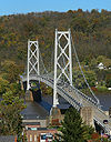
| Covington and Cincinnati Suspension Bridge |  |
1856, 1867 | 1975-05-15 | Covington Covington, Kentucky -Demographics:As of the census of 2000, there were 43,370 people, 18,257 households, and 10,132 families residing in the city. The population density was 3,301.3 people per square mile . There were 20,448 housing units at an average density of 1,556.5 per square mile... 39°5′32"N 84°30′34"W |
Kenton Kenton County, Kentucky Kenton County is a county located in the Commonwealth of Kentucky, United States. It was formed in 1840. In 2010, the population was 159,720. It is the third most populous county in Kentucky behind Jefferson County and Fayette County. Its county seats are Covington and Independence... |
Suspension bridge | |
| Doe Run Trestle | 1989-02-10 | Springfield Springfield, Kentucky Springfield is a city in and county seat of Washington County, Kentucky, United States. The population was 2,634 at the 2000 census. It was established in 1793 and probably named for springs in the area.-Geography:... 37°46′40"N 85°17′40"W |
Washington Washington County, Kentucky Washington County is a county located in the U.S. state of Kentucky. As of 2000, the population was 10,916. Its county seat is Springfield. The county is named for George Washington. Washington County was the first county formed in the Commonwealth of Kentucky when it reached statehood... |
||||
| East Main Street Bridge | 1890, 1905 | 1986-03-28 | Corbin Corbin, Kentucky - Economy :Originally formed by L&N Railroad, rail transport was the backbone of the local economy in the first half of the twentieth century. While the railroad continues to play an important role, the decline of the rail industry in the latter half of the twentieth century, as well as the loss... 36°57′5"N 84°5′7"W |
Knox Knox County, Kentucky Knox County is a county located in the U.S. state of Kentucky. As of 2000, the population was 31,795. Its county seat is Barbourville. The county is named for General Henry Knox... , Whitley Whitley County, Kentucky Whitley County is a county located in the state of Kentucky. 2005 census projections list its population at 38,029 . The county seat is at Williamsburg, though the largest city is Corbin, and the county's District Court sits in both cities... |
Pratt through truss | ||
| General U.S. Grant Bridge | 1927, 1939 | 2001-05-31 | South Portsmouth 38°43′29"N 82°59′53"W |
Greenup Greenup County, Kentucky Greenup County is a county located in the U.S. state of Kentucky. It was formed in 1804. As of 2000, the population was 36,891. Its county seat is Greenup. The county is named in honor of Christopher Greenup.... |
Cable suspension bridge | ||
| Goddard Bridge Goddard Bridge Spanning the Goddard Bridge crosses the Sand Lick Creek just off Kentucky 32, about 8 miles south of Flemingsburg on Maddox road in Goddard, Ky. The Pea Ridge Mountains and an old country church provide a scenic backdrop.... |
1933 | 1975-08-22 | Goddard 38°21′44"N 83°36′56"W |
Fleming Fleming County, Kentucky Fleming County is a county located in the U.S. state of Kentucky. It was formed in 1798. As of 2000, the population was 13,792. Its county seat is Flemingsburg. The county is named for Colonel John Fleming. It's a prohibition or dry county... |
|||
| Goose Creek Foot Bridge | 1928 | 1985-04-19 | Greensburg Greensburg, Kentucky Greensburg is a city in Green County, Kentucky, United States. The population was 2,396 at the 2000 census. It is the county seat of Green County... 37°15′36"N 85°30′1"W |
Green Green County, Kentucky Green County is a county located in the U.S. state of Kentucky. It was formed in 1793. As of 2000, the population was 11,518. Its county seat is Greensburg. The county is named for Nathanael Greene... |
|||
| Hillsboro Covered Bridge Hillsboro Covered Bridge The Hillsboro Covered Bridge, known locally as the "Hillsboro-Grange City Covered Bridge", spans Fox Creek in Fleming County adjacent to Kentucky Route 111, 13.6 miles southeast of Flemingsburg, Kentucky... |
1976-03-26 | Hillsboro 38°15′17"N 83°39′11"W |
Fleming Fleming County, Kentucky Fleming County is a county located in the U.S. state of Kentucky. It was formed in 1798. As of 2000, the population was 13,792. Its county seat is Flemingsburg. The county is named for Colonel John Fleming. It's a prohibition or dry county... |
||||
| Hornsby Bridge | 1903 | 1988-12-27 | Eminence Eminence, Kentucky Eminence is a city in Henry County, Kentucky, United States. The population was 2,231 at the 2000 census. Eminence is the largest city in Henry County. Eminence is home to the world's largest loudspeaker manufacturing company, Eminence Speaker... 38°19′4"N 85°12′16"W |
Shelby Shelby County, Kentucky Shelby County is a county located in the U.S. state of Kentucky. As of 2010, the population was 42,074. Its name is in honor of Isaac Shelby, the first Governor of Kentucky. Its county seat is Shelbyville... |
|||
| Johnson Creek Covered Bridge | 1874 | 1976-09-27 | Mount Olivet Mount Olivet, Kentucky Mount Olivet is a city in and the county seat of Robertson County, Kentucky, United States. The population was 289 at the 2000 census. The population has declined from 442 in 1970, 346 in 1980, and 384 in 1990.... 38°28′52"N 83°58′37"W |
Robertson Robertson County, Kentucky Robertson County is a county located in the U.S. state of Kentucky. As of 2010, the population was 2,282. Its county seat is Mount Olivet, Kentucky. The county is named for George Robertson, a Kentucky Congressman from 1817 to 1821. Robertson is a prohibition or dry county... |
Smith Truss | ||
| KY 2541 Bridge | 1884 | 1988-01-27 | Greenup Greenup, Kentucky Greenup is a city in Greenup County, Kentucky, at the confluence of the Ohio and Little Sandy Rivers. The population was 1,198 at the 2000 census. It is the county seat of Greenup County. Greenup is named in honor of Christopher Greenup.... 38°34′50"N 82°50′25"W |
Greenup Greenup County, Kentucky Greenup County is a county located in the U.S. state of Kentucky. It was formed in 1804. As of 2000, the population was 36,891. Its county seat is Greenup. The county is named in honor of Christopher Greenup.... |
Pratt through truss | ||
| Lee's Creek Covered Bridge Lee's Creek Covered Bridge Lee's Creek Covered Bridge is a historic wooden bridge on Lee's Creek Road south of Kentucky Route 8 near Dover, Kentucky. It is long with a double set of Queen post trusses on each side.... |
1835 | 1976-03-26 | Dover Dover, Kentucky Dover is a city in Mason County, Kentucky, United States. The population was 316 at the 2000 census. It is part of the Maysville Micropolitan Statistical Area.-Geography:Dover is located at .... 38°44′59"N 83°52′44"W |
Mason Mason County, Kentucky Mason County is a county located in the U.S. state of Kentucky. As of 2000, the population was 16,800. Its county seat is Maysville. The county is named for George Mason, a Virginia delegate to the U.S. Constitutional Convention, known as the "Father of the Bill of Rights"... |
Queenpost design | ||
| Long Lick Creek Bridge | 1989-02-10 | Willisburg Willisburg, Kentucky Willisburg is a city in Washington County, Kentucky, United States. The population was 304 at the 2000 census. The center of population of Kentucky is located in Willisburg .-Geography:Willisburg is located at .... 37°48′38"N 85°12′45"W |
Washington Washington County, Kentucky Washington County is a county located in the U.S. state of Kentucky. As of 2000, the population was 10,916. Its county seat is Springfield. The county is named for George Washington. Washington County was the first county formed in the Commonwealth of Kentucky when it reached statehood... |
Single span metal truss | |||
| Louisville Municipal Bridge, Pylons and Administration Building | 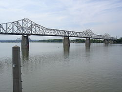 |
1928, 1929 | 1984-03-08 | Louisville Louisville, Kentucky Louisville is the largest city in the U.S. state of Kentucky, and the county seat of Jefferson County. Since 2003, the city's borders have been coterminous with those of the county because of a city-county merger. The city's population at the 2010 census was 741,096... |
Clark Clark County, Kentucky Clark County is a county located in the U.S. state of Kentucky. It was formed in 1793. The population was 35,613 in the 2010 Census. Its county seat is Winchester, Kentucky... , Jefferson Jefferson County, Kentucky As of the census of 2000, there were 693,604 people, 287,012 households, and 183,113 families residing in the county. The population density was . There were 305,835 housing units at an average density of... |
Warren through truss | |
| Maysville-Aberdeen Bridge Simon Kenton Memorial Bridge The Simon Kenton Memorial Bridge is a suspension bridge built in 1931 that crosses the Ohio River and connects Maysville, Kentucky and Aberdeen, Ohio. Its main span is 1,060 feet long, and the total length of the bridge is 1,991 feet... |
 |
1930, 1931 | 1983-06-30 | Maysville Maysville, Kentucky Maysville is a city in and the county seat of Mason County, Kentucky, United States. The population was 8,993 at the 2000 census, making it the fiftieth largest city in Kentucky by population. Maysville is on the Ohio River, northeast of Lexington. It is the principal city of the Maysville... 38°39′19"N 83°45′27"W |
Mason Mason County, Kentucky Mason County is a county located in the U.S. state of Kentucky. As of 2000, the population was 16,800. Its county seat is Maysville. The county is named for George Mason, a Virginia delegate to the U.S. Constitutional Convention, known as the "Father of the Bill of Rights"... |
Steel Suspension | |
| Mitchellsburg Louisville and Nashville Railroad Culvert | 1998-04-09 | Mitchellsburg 37°36′5"N 84°57′10"W |
Boyle Boyle County, Kentucky Boyle County is a county located in the U.S. state of Kentucky. Its county seat is Danville. In 2000, its population was 28,432. It was formed in 1842 and named for John Boyle , a U.S... |
brick and stone culvert | |||
| Mount Zion Covered Bridge | 1871 | 1976-03-26 | Mooresville 37°49′40"N 85°15′23"W |
Washington Washington County, Kentucky Washington County is a county located in the U.S. state of Kentucky. As of 2000, the population was 10,916. Its county seat is Springfield. The county is named for George Washington. Washington County was the first county formed in the Commonwealth of Kentucky when it reached statehood... |
Burr truss | ||
| Newport and Cincinnati Bridge |  |
1868, 1872, 1896 | 2001-04-17 | Newport Newport, Kentucky Newport is a city in Campbell County, Kentucky, United States, at the confluence of the Ohio and Licking rivers. The population was 15,273 at the 2010 census. Historically, it was one of four county seats of Campbell County. Newport is part of the Greater Cincinnati, Ohio Metro Area which... 39°6′3"N 84°30′2"W |
Campbell Campbell County, Kentucky Campbell County is a county located in the U.S. state of Kentucky. It was formed on December 17, 1794, from sections of Scott, Harrison and Mason counties. As of 2010, the population was 90,336. Its county seats are Alexandria and Newport... |
Subdivided Pratt truss | |
| Oldtown Covered Bridge | 1976-03-26 | Oldtown 38°25′53"N 82°53′42"W |
Greenup Greenup County, Kentucky Greenup County is a county located in the U.S. state of Kentucky. It was formed in 1804. As of 2000, the population was 36,891. Its county seat is Greenup. The county is named in honor of Christopher Greenup.... |
||||
| Pauley Bridge | 1940 | 1992-03-26 | Pikeville Pikeville, Kentucky Pikeville is a city in Pike County, Kentucky. The population was 6,903 at the 2010 census. It is the county seat of Pike County.-History:On March 25, 1822, the county's government officials decided to build a new county seat named Liberty, one and one-half mile below the mouth of the Russell Fork... 37°29′33"N 82°32′8"W |
Pike Pike County, Kentucky Pike County is a county located in the U.S. state of Kentucky. As of 2010, the population was 65,024. Its county seat is Pikeville. Pike is Kentucky's largest county in terms of land area. Pike County is the 11th largest county in Kentucky in terms of population preceded by Bullitt County and... |
Suspension bridge | ||
| Richardsville Road Bridge | 1980-11-26 | Bowling Green Bowling Green, Kentucky Bowling Green is the third-most populous city in the state of Kentucky after Louisville and Lexington, with a population of 58,067 as of the 2010 Census. It is the county seat of Warren County and the principal city of the Bowling Green, Kentucky Metropolitan Statistical Area with an estimated 2009... 37°1′14"N 86°26′51"W |
Warren Warren County, Kentucky Warren County is a county located in the U.S. state of Kentucky, specifically the Pennyroyal Plateau and Western Coal Fields regions. It is included in the Bowling Green, Kentucky, Metropolitan Statistical Area. The population was 113,792 in the 2010 Census. The county seat is Bowling Green... |
Bowstring | |||
| Ringos Mill Covered Bridge Ringos Mill Covered Bridge The Ringos Mill Covered Bridge spans Fox Creek in Fleming County in a single 90-foot span. It was named for a grist mill situated 50 yards downstream.... |
1867 | 1976-03-26 | Flemingsburg Flemingsburg, Kentucky Flemingsburg is a city in Fleming County, Kentucky, United States. The population was 3,010 at the 2000 census. It is the county seat of Fleming County.-Geography:Flemingsburg is located at .... 38°16′6"N 83°36′38"W |
Fleming Fleming County, Kentucky Fleming County is a county located in the U.S. state of Kentucky. It was formed in 1798. As of 2000, the population was 13,792. Its county seat is Flemingsburg. The county is named for Colonel John Fleming. It's a prohibition or dry county... |
|||
| Stone Bridge at Chaplin Creek | 1998-04-09 | Parksville Parksville, Kentucky Parksville is a small unincorporated community on the Chaplin River in south central Boyle County, Kentucky, United States. It is located at the eastern end of Ky Route 300, where it intersects with Ky Route 34, near the US Post Office. The global position of Parksville is 37.597N latitude and... 37°35′51"N 84°54′38"W |
Boyle Boyle County, Kentucky Boyle County is a county located in the U.S. state of Kentucky. Its county seat is Danville. In 2000, its population was 28,432. It was formed in 1842 and named for John Boyle , a U.S... |
stone bridge | |||
| Switzer Covered Bridge | 1855 | 1974-09-06 | Switzer 38°15′14"N 84°45′8"W |
Franklin Franklin County, Kentucky As of the census of 2000, there were 47,687 people, 19,907 households, and 12,840 families residing in the county. The population density was . There were 21,409 housing units at an average density of... |
|||
| Tank Pond Railroad Underpass | 1915 | 1998-04-09 | Mitchellsburg 37°35′44"N 84°54′39"W |
Boyle Boyle County, Kentucky Boyle County is a county located in the U.S. state of Kentucky. Its county seat is Danville. In 2000, its population was 28,432. It was formed in 1842 and named for John Boyle , a U.S... |
engineering structure | ||
| Town Branch Bridge | 1932 | 1989-05-18 | Prestonsburg Prestonsburg, Kentucky Prestonsburg is a city in and the county seat of Floyd County, Kentucky, United States. It lies in the eastern part of the state, along the banks of the Levisa Fork of the Big Sandy River. It was founded in 1797 by Col. John Preston—for whom it was named—along with Solomon Stratton, Matthias... 37°39′49"N 82°46′23"W |
Floyd Floyd County, Kentucky Floyd County is a county located in the U.S. state of Kentucky. It was formed in 1800. As of 2000, the population was 42,441. Its county seat is Prestonsburg. The county is named for Colonel John Floyd .-History:... |
Open-spandrel rainbow arch | ||
| Valley Pike Covered Bridge Valley Pike Covered Bridge The Valley Pike Covered Bridge is a historic bridge located in Mason County, Kentucky. It crosses the Frasure Branch of Lee Creek. It was added to the National Register of Historic Places in 1976.... |
 |
1976-03-26 | Maysville Maysville, Kentucky Maysville is a city in and the county seat of Mason County, Kentucky, United States. The population was 8,993 at the 2000 census, making it the fiftieth largest city in Kentucky by population. Maysville is on the Ohio River, northeast of Lexington. It is the principal city of the Maysville... 38°40′27"N 83°52′20"W |
Mason Mason County, Kentucky Mason County is a county located in the U.S. state of Kentucky. As of 2000, the population was 16,800. Its county seat is Maysville. The county is named for George Mason, a Virginia delegate to the U.S. Constitutional Convention, known as the "Father of the Bill of Rights"... |
Single Kingpost truss | ||
| Walcott Covered Bridge Walcott Covered Bridge The Walcott Covered Bridge The Walcott Covered Bridge is situated at a point where Kentucky Highway 1159 previously crossed Locust Creek in Bracken County, Kentucky. A concrete bridge was constructed in 1954, about 200 feet northwest of the covered bridge and the older structure was then... |
1975-06-10 | Brooksville Brooksville, Kentucky Brooksville is a city in Bracken County, Kentucky, in the United States. As of the 2000 census, the city's population was 589. It is the county seat of Bracken County.... 38°44′0"N 84°6′2"W |
Bracken Bracken County, Kentucky Bracken County is a county located in the U.S. state of Kentucky. It was formed in 1797. The population was 8,488 in the 2010 Census. Its county seat is Brooksville, Kentucky.-History:... |
Queen & King post type truss | |||
| West Prestonsburg Bridge | 1928 | 1989-05-18 | Prestonsburg Prestonsburg, Kentucky Prestonsburg is a city in and the county seat of Floyd County, Kentucky, United States. It lies in the eastern part of the state, along the banks of the Levisa Fork of the Big Sandy River. It was founded in 1797 by Col. John Preston—for whom it was named—along with Solomon Stratton, Matthias... 37°40′20"N 82°46′46"W |
Floyd Floyd County, Kentucky Floyd County is a county located in the U.S. state of Kentucky. It was formed in 1800. As of 2000, the population was 42,441. Its county seat is Prestonsburg. The county is named for Colonel John Floyd .-History:... |
Rainbow arch single span | ||
| Yatesville Covered Bridge | 1907 | 1976-03-26 | Fallsburg 38°8′41"N 82°41′5"W |
Lawrence Lawrence County, Kentucky Lawrence County is a county located in the U.S. state of Kentucky. As of 2000, the population was 15,569. Its county seat is Louisa. The county is named for James Lawrence, and co-founded by Isaac Bolt, who served as a Lawrence County Commissioner and Justice of the Peace. It is the home of... |
Howe Truss | ||
| East Fork Covered Bridge | 1924 | removed 1982-04-09 |
Fallsburg | Lawrence Lawrence County, Kentucky Lawrence County is a county located in the U.S. state of Kentucky. As of 2000, the population was 15,569. Its county seat is Louisa. The county is named for James Lawrence, and co-founded by Isaac Bolt, who served as a Lawrence County Commissioner and Justice of the Peace. It is the home of... |
|||
| Sherburne Covered Suspension Bridge | 1867, 1868 | removed 1990-02-06 |
Sherburne | Fleming Fleming County, Kentucky Fleming County is a county located in the U.S. state of Kentucky. It was formed in 1798. As of 2000, the population was 13,792. Its county seat is Flemingsburg. The county is named for Colonel John Fleming. It's a prohibition or dry county... |