

List of beaches in Oregon
Encyclopedia
List of beaches in Oregon enumerates all landmarks designated as a beach
in the U.S. state
of Oregon
.
Beach
A beach is a geological landform along the shoreline of an ocean, sea, lake or river. It usually consists of loose particles which are often composed of rock, such as sand, gravel, shingle, pebbles or cobblestones...
in the U.S. state
U.S. state
A U.S. state is any one of the 50 federated states of the United States of America that share sovereignty with the federal government. Because of this shared sovereignty, an American is a citizen both of the federal entity and of his or her state of domicile. Four states use the official title of...
of Oregon
Oregon
Oregon is a state in the Pacific Northwest region of the United States. It is located on the Pacific coast, with Washington to the north, California to the south, Nevada on the southeast and Idaho to the east. The Columbia and Snake rivers delineate much of Oregon's northern and eastern...
.
| name | elevation | coordinate | USGS Map | GNIS url |
|---|---|---|---|---|
| Agate Beach (Cape Arago, Oregon) | 13 ft (4 m) | 43°15′11"N 124°23′14"W | Cape Arago | |
| Agate Beach (Tillamook, Oregon) | 13 ft (4 m) | 45°27′57"N 123°58′28"W | Netarts | |
| Agate Beach (Port Orford, Oregon) | 23 ft (7 m) | 42°44′52"N 124°30′49"W | Port Orford OE W | |
| Agate Beach (Gold Beach, Oregon) | 3 ft (0.9144 m) | 42°28′14"N 124°25′19"W | Gold Beach | |
| Arcadia Beach (Oregon) | 23 ft (7 m) | 45°50′21"N 123°57′40"W | Arch Cape | |
| Arizona Beach (Oregon) | 7 ft (2.1 m) | 42°36′54"N 124°23′59"W | Ophir | |
| Baker Beach (Oregon) | 10 ft (3 m) | 44°04′34"N 124°07′36"W | Mercer Lake OE W | |
| Bandon Beach (Coos County, Oregon) | 0 ft (0 m) | 43°06′37"N 124°26′12"W | Bandon | |
| Barley Beach (Oregon) | 36 ft (11 m) | 42°27′24"N 124°25′19"W | Gold Beach | |
| Bastendorff Beach | 0 ft (0 m) | 43°20′43"N 124°20′54"W | Charleston | |
| Broughton Beach | 10 ft (3 m) | 45°35′59"N 122°36′19"W | Mount Tabor | |
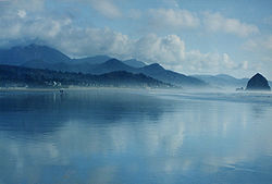
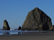
| Cannon Beach, Oregon Cannon Beach, Oregon Cannon Beach is a city in Clatsop County, Oregon, United States. The population was 1,588 as of the 2000 census. The 2007 estimate is 1,680 residents.- History :... |
20 ft (6.1 m) | 45°52′54"N 123°57′51"W | Tillamook Head | |
| Chapman Beach | 46 ft (14 m) | 45°54′12"N 123°57′50"W | Tillamook Head | |
| Cottonwood Beach (Oregon) | 7 ft (2.1 m) | 46°04′44"N 122°54′19"W | Rainier | |
| Cove Beach, Oregon | 26 ft (7.9 m) | 45°47′17"N 123°58′05"W | Arch Cape | |
| Crescent Beach (Oregon) | 46 ft (14 m) | 45°54′52"N 123°58′13"W | Tillamook Head | |
| Dibblees Beach | 3 ft (0.9144 m) | 46°07′01"N 122°59′19"W | Rainier | |
| Goble Beach (Oregon) | 10 ft (3 m) | 46°01′09"N 122°52′29"W | Kalama | |
| Harris Beach (Oregon) | 26 ft (7.9 m) | 42°03′51"N 124°18′18"W | Brookings | |
| Holly Beach (Oregon) | 13 ft (4 m) | 44°28′11"N 124°04′54"W | Waldport | |
| Indian Beach (Oregon) | 33 ft (10.1 m) | 45°55′40"N 123°58′40"W | Tillamook Head | |
| Jones Beach (Oregon) | 7 ft (2.1 m) | 46°08′21"N 123°18′34"W | Nassa Point | |
| Kiwanda Beach | 46 ft (14 m) | 45°09′05"N 123°58′27"W | Nestucca Bay | |
| Koberg Beach | 79 ft (24.1 m) | 45°41′57"N 121°28′03"W | White Salmon | |
| Lighthouse Beach (Oregon) | 30 ft (9.1 m) | 43°20′20"N 124°21′59"W | Charleston | |
| Lone Ranch Beach | 3 ft (0.9144 m) | 42°05′54"N 124°20′34"W | Brookings | |
| Lyons Beach (Oregon) | 13 ft (4 m) | 45°49′59"N 122°47′49"W | Saint Helens | |
| McNary Beach (Oregon) | 344 ft (104.9 m) | 45°55′44"N 119°16′54"W | Umatilla | |
| Merchants Beach (Coos County, Oregon) | 0 ft (0 m) | 43°14′13"N 124°23′31"W | Bullards | |
| Moolack Beach Moolack Beach Moolack Beach is an undeveloped sandy beach on the Oregon Coast about 4 miles north of Newport in Lincoln County, United States. It is almost 8 km in length with the south end at Yaquina Head and the north end at Otter Rock, the site of Devils Punch Bowl State Natural Area... |
0 ft (0 m) | 44°41′59"N 124°03′55"W | Newport North | |
| Nehalem Beach | 23 ft (7 m) | 45°39′59"N 123°56′14"W | Nehalem | |
| Neskowin Beach | 7 ft (2.1 m) | 45°06′04"N 123°59′09"W | Neskowin | |
| North Beach (Oregon) | 23 ft (7 m) | 43°23′05"N 124°18′59"W | Empire | |
| Nye Beach | 23 ft (7 m) | 44°38′32"N 124°03′44"W | Newport North | |
| Ona Beach | 0 ft (0 m) | 44°31′34"N 124°04′34"W | Newport South | |
| Ophir Beach Ophir Beach Ophir Beach is an undeveloped sandy beach on the Oregon Coast seven miles north of Gold Beach in Curry County, United States. It is more than in length with the south end at Nesika Beach and the north end at a cape named the Devils Backbone. The beach is bounded by U.S. Route 101 on the east... |
82 ft (25 m) | 42°32′59"N 124°23′39"W | Ophir | |
| Pumice Beach (Oregon) | 5200 ft (1,585 m) | 43°08′59"N 122°09′59"W | Diamond Lake | |
| Red Mill Beach (Oregon) | 3 ft (0.9144 m) | 46°05′14"N 122°55′19"W | Rainier | |
| Sacchi Beach | 16 ft (4.9 m) | 43°15′51"N 124°23′01"W | Cape Arago | |
| San Salvador Beach (Oregon) | 79 ft (24.1 m) | 45°13′18"N 123°01′37"W | Dayton | |
| Short Beach (Oregon) Short Beach (Oregon) Short Beach is a 1,000-meter stretch of beach on the northern Oregon Coast in the United States. It is not named for its length. Locals guess that both the beach and the creek that runs onto it—Short Creek, several miles in length—were named after an early resident of the area... |
115 ft (35.1 m) | 45°28′29"N 123°58′06"W | Netarts | |
| Short Sand Beach | 59 ft (18 m) | 45°45′45"N 123°58′02"W | Arch Cape | |
| Sixes Beach (Oregon) | 0 ft (0 m) | 42°51′04"N 124°32′44"W | Cape Blanco | |
| Sundial Beach (Oregon) | 20 ft (6.1 m) | 45°34′00"N 122°24′18"W | Camas | |
| Sunset Beach (Gearhart, Oregon) | 20 ft (6.1 m) | 46°05′19"N 123°56′09"W | Gearhart | |
| Sunset Beach (Nehalem, Oregon) | 33 ft (10.1 m) | 45°41′38"N 123°56′20"W | Nehalem | |
| Sunset Beach (Tillamook, Oregon) | 108 ft (32.9 m) | 45°58′29"N 123°56′49"W | Tillamook Head | |
| Wakeman Beach (Oregon) | 13 ft (4 m) | 42°29′14"N 124°25′14"W | Gold Beach | |
| Westport Beach (Oregon) | 7 ft (2.1 m) | 46°08′39"N 123°22′44"W | Cathlamet | |
| Whisky Run Beach (Oregon) | 10 ft (3 m) | 43°12′42"N 124°23′42"W | Bullards | |
| Wilson Beach (Oregon) | 43 ft (13.1 m) | 45°25′41"N 123°56′16"W | Netarts |