

List of airports in Nepal
Encyclopedia
Airport
An airport is a location where aircraft such as fixed-wing aircraft, helicopters, and blimps take off and land. Aircraft may be stored or maintained at an airport...
s in Nepal
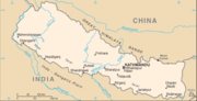
Nepal
Nepal , officially the Federal Democratic Republic of Nepal, is a landlocked sovereign state located in South Asia. It is located in the Himalayas and bordered to the north by the People's Republic of China, and to the south, east, and west by the Republic of India...
, sorted by location.
Nepal , officially the Federal Democratic Republic of Nepal, is a landlocked
Landlocked
A landlocked country is a country entirely enclosed by land, or whose only coastlines lie on closed seas. There are 48 landlocked countries in the world, including partially recognized states...
country in South Asia
South Asia
South Asia, also known as Southern Asia, is the southern region of the Asian continent, which comprises the sub-Himalayan countries and, for some authorities , also includes the adjoining countries to the west and the east...
. It is bordered to the north by the People's Republic of China
People's Republic of China
China , officially the People's Republic of China , is the most populous country in the world, with over 1.3 billion citizens. Located in East Asia, the country covers approximately 9.6 million square kilometres...
, and to the south, east, and west by the Republic of India. Nepal
Nepal
Nepal , officially the Federal Democratic Republic of Nepal, is a landlocked sovereign state located in South Asia. It is located in the Himalayas and bordered to the north by the People's Republic of China, and to the south, east, and west by the Republic of India...
is divided into 14 administrative zones (अञ्चल, "anchal"), which are divided into 75 districts (जिल्ला, "jilla"). The nation's capital and the country's largest metropolitan
Metropolis
A metropolis is a very large city or urban area which is a significant economic, political and cultural center for a country or region, and an important hub for regional or international connections and communications...
city is Kathmandu.
Airports
Airport names shown in bold indicate the airport has scheduled service on commercial airlines.| Location served | ICAO ICAO airport code The ICAO airport code or location indicator is a four-character alphanumeric code designating each airport around the world. These codes are defined by the International Civil Aviation Organization, and published in ICAO Document 7910: Location Indicators.The ICAO codes are used by air traffic... |
IATA IATA airport code An IATA airport code, also known an IATA location identifier, IATA station code or simply a location identifier, is a three-letter code designating many airports around the world, defined by the International Air Transport Association... |
Airport name | Coordinates Geographic coordinate system A geographic coordinate system is a coordinate system that enables every location on the Earth to be specified by a set of numbers. The coordinates are often chosen such that one of the numbers represent vertical position, and two or three of the numbers represent horizontal position... |
|---|---|---|---|---|
| Baglung Baglung Baglung, is a town in western Nepal, 275 km west of Kathmandu. It is the administrative headquarters of Baglung District and Dhawalagiri Zone. Baglung is a major business, financial, educational, and healthcare center for the people of Kali Gandaki valley.... |
VNBL | BGL | Baglung Airport | 28°12′46"N 083°39′59"E |
| Baitadai | VNBT | BIT | Baitadai Airport | 29°27′50"N 080°32′58"E |
| Bajhang | VNBG | BJH | Bajhang Airport Bajhang Airport Bajhang Airport is an airport serving Bajhang, a district in the Seti Zone in Nepal.-Facilities:The airport resides at an elevation of above mean sea level. It has one runway which is in length.... |
29°32′18"N 081°11′02"E |
| Bajura Bajura District -Towns and villages:Atichaur,Baddhu,Wai,Barhabise,Bichhiya,Bramhatola,Budhiganga,Chhatara,Dahakot,Dogadi,Gotree,Gudukhati,Jagannath,Jayabageswori,Jugada,Kailashmandau,Kanda,Kolti,Kotila,Kuldeumadau,Manakot,Martadi,Pandusain,Rugin,Sappata,... |
VNBR | BJU | Bajura Airport Bajura Airport Bajura Airport is an airport serving Bajura, a district in the Seti Zone in Nepal.-Facilities:The airport resides at an elevation of above mean sea level. It has one runway which is in length.-Airlines and destinations:... |
29°30′10"N 081°40′04"E |
| Bhadrapur Bhadrapur, Mechi Bhadrapur is a town and municipality in Jhapa District in the Mechi Zone of south-eastern Nepal. It is known As a one of oldest municipalities of Nepal. At the time of the 2001 Nepal census it had a population of 18,145 people.... / Chandragadhi Chandragadhi Chandragadhi is a town and municipality and district headquarters of Jhapa District in the Mechi Zone of south-eastern Nepal. At the time of the 1991 Nepal census it had a population of 12,259 people living in 2345 individual households.... |
VNCG | BDP | Bhadrapur Airport Bhadrapur Airport Bhadrapur Airport , also known as Chandragadhi Airport, is an airport serving Bhadrapur and Chandragadhi, both towns in the Jhapa district in the Mechi zone in Nepal.-Facilities:The airport resides at an elevation of above mean sea level... (Chandragadhi Airport) |
26°34′14"N 088°04′45"E |
| Bhairahawa | VNBW | BWA | Gautam Buddha Airport Gautam Buddha Airport Gautam Buddha Airport , also known as Bhairahawa Airport, is an airport serving Bhairahawa , a municipality of the Rupandehi district in the Lumbini zone in Nepal. Rabin Sharma served as the chief of the airport until 2008.-Facilities:... (Bhairahawa Airport) |
27°30′20"N 083°24′58"E |
| Bharatpur Bharatpur, Nepal Bharatpur is a city in the central-southern part of Nepal. Located in Chitwan Valley, Bharatpur is the district headquarters of the Chitwan District, as well as a separate Municipal authority, and is the seventh largest city of Nepal with the population of 89,323 . The estimated population for... |
VNBP | BHR | Bharatpur Airport Bharatpur Airport Bharatpur Airport is an airport serving Bharatpur, a city in the Chitwan district in Narayani zone in Nepal.The airport is located southwest of Bharatpu. It is operated by the Civil Aviation Authority of Nepal and is served by Nepal Airlines, the national airline which earns most of its revenue... |
27°40′41"N 084°25′46"E |
| Bhojpur Bhojpur, Nepal Bhojpur is a town in Eastern Nepal. It is the district headquarters of Bhojpur district, a hilly/mountainous district in Kosi Zone. At the time of the 1991 Nepal census it had a population of 5823 people living in 1199 households.... |
VNBJ | BHP | Bhojpur Airport Bhojpur Airport Bhojpur Airport is an airport serving Bhojpur, a town in the Bhojpur district in the Kosi zone in Nepal.-Facilities:The airport resides at an elevation of above mean sea level. It has one runway which is in length. This airport has helped the people of Bhojpur as there is only about 3.5 km of... |
27°08′51"N 087°03′03"E |
| Biratnagar | VNVT | BIR | Biratnagar Airport Biratnagar Airport Biratnagar Airport is an airport serving Biratnagar, a city of the Morang district in the Kosi zone in Nepal.-Facilities:Nepal government owned and operated, Biratnagar Airport began its service on 6 July 1958, the same year the nation's first Royal Nepal Airlines began its scheduled domestic and... |
26°28′53"N 087°15′50"E |
| Chaurjhari | VNCJ | HRJ | Chaurjhari Airport Chaurjhari Airport Chaurjhari Airport is an airport serving Chaurjhari, in the Rukum district of the Rapti zone in Nepal.... |
28°00′N 083°50′E |
| Dang (Tulsipur Tulsipur, Rapti Tulsipur is a town and V.D.C. in Dang Deokhuri District in the Rapti Zone of south-western Nepal. It is also the district's main bazaar. The 1991 Nepal census counted 13,815 persons in 2,540 households. Dang Airport is about two km south of the town center... / Tribhuvannagar Tribhuvannagar Tribhuvan Nagar, renamed as Ghorahi is a municipality of Dang Valley, Dang Deokhuri District of Rapti Zone, southwest Nepal.Tribhuvannagar can be reached by the road that goes 23 kilometers North from Lamahi, a small town on the Mahendra highway.... ) |
VNDG | DNP | Dang Airport (Tulsipur Airport, Tribhuvannagar Airport) | 28°06′40"N 082°17′39"E |
| Darchula | VNDL | DAP | Darchula Airport | 29°40′09"N 080°32′54"E |
| Dhangadhi Dhangadhi Dhangadhi is a city in Far western Nepal bordering India. It is the capital of Kailali District in the province of Seti.Located in the Far Western Region of Nepal on the border of India, the city of Dhangadhi is one of the entry points into the country for people traveling from India.It was... |
VNDH | DHI | Dhangadhi Airport Dhangadhi Airport Dhangadhi Airport is an airport serving Dhangadhi, the capital city of the Kailali District in the Seti Zone in Nepal.-Facilities:The airport resides at an elevation of above mean sea level. It has one runway which is in length. This airport has recently been extended and black topped to be able... (Dhangarhi Airport) |
28°45′12"N 080°34′55"E |
| Dolpa Dolpa District -Geography:Dolpa is the largest district of Nepal covering 5.36% of the total landmass of the country. Located between 28°24’ N - 29°43’ N latitude, and 82°24’ E - 83°38’ E longitude, the elevation in Dolpa ranges from above sea level... |
VNDP | DOP | Dolpa Airport Dolpa Airport Dolpa Airport is an airport serving Dolpa, a district in the Karnali zone in Nepal.-Facilities:The airport resides at an elevation of above mean sea level. It has one runway designated 06/24 with a dirt surface measuring .-Airlines and destinations:... |
28°59′09"N 082°49′09"E |
| Doti Doti District -History:Doti was a medieval kingdom of Nepal founded by Niranjan Malla Deo, the younger brother of Abhay Pal of Askot. Rulers of Doti were called 'Raika'... |
VNDT | SIH | Doti Airport (Silgadi Doti Airport) | 29°15′47"N 080°56′10"E |
| Gorkha | VNGK | GKH | Gorkha Airport | 28°03′N 084°29′E |
| Janakpur | VNJP | JKR | Janakpur Airport Janakpur Airport Janakpur Airport is an airport serving Janakpur, a city in and the administrative headquarters of the Dhanusa District in the Janakpur Zone in Nepal.-Facilities:... |
26°42′31"N 085°55′20"E |
| Jiri Jiri Jiri is a village development committee in Dolakha District in the Janakpur Zone of north-eastern Nepal. At the time of the 1991 Nepal census it had a population of 7,138 people living in 1,508 individual households.... |
VNJI | JIR | Jiri Airport | 27°37′N 086°13′E |
| Jomsom Jomsom Jomsom , also known as Dzongsam or New Fort, is a town located at an altitude of 2800m in Mustang, Nepal. It extends over both the banks of the Kali Gandaki River. Along the banks of Kali Gandaki river there are rocks holy to the Hindus. The soaring peaks of Dhaulagiri and Nilgiri form a backdrop... |
VNJS | JMO | Jomsom Airport Jomsom Airport Jomsom Airport is an airport serving Jomsom, a town in the Mustang District of the Dhawalagiri Zone in Nepal. It is known as one of the world's most dangerous airfields and is a particular favourite of flight simulator fans.-Facilities:... |
28°46′56"N 083°43′21"E |
| Jumla Jumla (town) Jumla is the capital of the Jumla District in the Karnali Zone of Nepal, a landlocked country of Southeast Asia. The town is located at an altitude of 2514 metres .-Geography:... |
VNJL | JUM | Jumla Airport Jumla Airport Jumla Airport is an airport serving Jumla, the capital of the Jumla District in the Karnali Zone in Nepal.-Facilities:The airport resides at an elevation of above mean sea level. It has one asphalt paved runway designated 09/27 which measures .... |
29°16′27"N 082°11′36"E |
| Kathmandu | VNKT | KTM | Tribhuvan International Airport Tribhuvan International Airport Tribhuvan International Airport is an international airport situated in Kathmandu, Nepal.Tribhuvan is the sole international airport in Nepal. There are two terminals, one domestic and one international... |
27°41′47"N 085°21′32"E |
| Lamidanda Lamidanda Not to be confused with Lamidanda of Kavrepalanchok District, a stop on the Araniko Highway.Lamidanda is a village and Village Development Committee in Khotang District in the Sagarmatha Zone of eastern Nepal. At the time of the 1991 Nepal census it had a population of 2,728 persons living in 478... |
VNLD | LDN | Lamidanda Airport Lamidanda Airport Lamidanda Airport is an airport serving Lamidanda, a village in the Khotang district of the Sagarmatha zone in Nepal.-Facilities:The airport resides at an elevation of above mean sea level... |
27°15′10"N 086°40′17"E |
| Langtang Langtang Langtang is a region in Nepal to the north of Kathmandu and bordering Tibet. It is protected as Langtang National Park and has a number of high peaks including Langtang Lirung . As of 2010, the entrance ticket to the park cost 2400 Nepali Rupees for foreigners.About 4,500 people live inside the... |
VNLT | LTG | Langtang Airport | 28°12′N 085°35′E |
| Lukla Lukla Lukla is a town in the Khumbu area of the Solukhumbu District in the Sagarmatha Zone of north-eastern Nepal. Situated at , it is a popular place for visitors to the Himalayas near Mount Everest to arrive... |
VNLK | LUA | Tenzing-Hillary Airport (Lukla Airport) | 27°41′16"N 086°43′53"E |
| Mahendranagar Mahendranagar Bhim Dutta, formerly Mahendranagar , is a city and municipality in far western Nepal, six kilometres from the border of India and the Mahakali River... |
VNMN | XMG | Mahendranagar Airport Mahendranagar Airport Mahendranagar Airport is an airport serving Mahendranagar, a city in the Kanchanpur district of the Mahakali zone in western Nepal.-Facilities:The airport resides at an elevation of above mean sea level. It has one runway which is in length.... |
28°57′48"N 080°08′53"E |
| Manang Manang Manang is a town in the Manang District of Nepal. It is located at 28°40'0N 84°1'0E with an altitude of . At the time of the 1991 Nepal census it had a population of 391 people living in 120 individual households.... |
VNMA | NGX | Manang Airport Manang Airport Manang Airport is an airport serving Manang valley, a town in the Manang district of the Gandaki zone in Nepal. The airport is situated 2,5 kilometer East of Manang town. -Facilities:... |
28°38′N 084°00′E |
| Meghauli Meghauli Meghauli is a village development committee in Chitwan District in the Narayani Zone of southern Nepal. At the time of the 1991 Nepal census it had a population of 12,281 people living in 2027 individual households.... |
VNMG | MEY | Meghauli Airport Meghauli Airport Meghauli Airport is an airport serving Meghauli, a village in the Chitwan district of the Narayani zone in southern Nepal.-Facilities:The airport resides at an elevation of above mean sea level. It has one runway which is in length.... |
27°35′N 084°14′E |
| Mountain | MWP | Mountain Airport | 28°00′N 085°20′E | |
| Nepalgunj Nepalgunj Nepalgunj , also spelled Nepalganj, is a municipality in Banke District, Nepal on the Terai plains near the southern border with Bahraich district, Uttar Pradesh state of India. It is 16 km south of Kohalpur and the east-west Mahendra Highway.... |
VNNG | KEP | Nepalgunj Airport Nepalgunj Airport Nepalgunj Airport is an airport serving Nepalgunj , a municipality in Banke district of the Bheri zone in Nepal.The airport has been in service since 1961. It is a major domestic hub after TIA in terms of number of airport network, and also second largest airport in Nepal in terms of land area,... |
28°06′13"N 081°40′01"E |
| Phaplu | VNPL | PPL | Phaplu Airport Phaplu Airport -External links:* at YouTube* at YouTube* at YouTube... |
27°31′05"N 086°35′04"E |
| Pokhara Pokhara Pokhara Sub-Metropolitan City is the second largest city of Nepal. Pokhara is city of close to 350,000 inhabitants in central Nepal located at 28.25°N, 83.99°E, which is the centre of the country from east to west or from north to south, 198 km west of Kathmandu or 90 km west of Mugling, and... |
VNPK | PKR | Pokhara Airport Pokhara Airport Pokhara Airport , is a regional airport serving Pokhara in Nepal. The airport was established July 4, 1958 and is operated by the government . It offers regular connections to Kathmandu, Jomsom and seasonal connections to Manang... |
28°12′03"N 083°58′55"E |
| Rajbiraj Rajbiraj Rajbiraj, a mid-sized town in south-eastern Nepal, 16 kilometers north of the Indian border. It is the administrative headquarters of the Saptari district. It has an airfield with flights to Kathmandu. The government planned to convert the airport to an international airport but the program is... |
VNRB | RJB | Rajbiraj Airport | 26°31′N 086°45′E |
| Ramechhap Ramechhap Ramechhap the headquarters of Ramechhap District in the Janakpur Zone of Nepal. It is located at 27°19'60N 86°4'60E with an altitude of 1218 metres .... |
VNRC | RHP | Ramechhap Airport Ramechhap Airport Ramechhap Airport is an airport serving Ramechhap, in the Ramechhap district of the Janakpur zone in Nepal.-Facilities:The airport resides at an elevation of above mean sea level. It has one runway which is in length.... |
27°23′38"N 086°03′41"E |
| Rara National Park Rara National Park Rara National Park is a protected area in the Himalayas of Nepal and was established in 1976. Covering an area of in the Mugu and Dolpa districts, it is the country's smallest national park. Its main feature is Rara Lake at an altitude of... |
TAL | Talcha Airport | 29°25′48"N 081°00′00"E | |
| Rolpa Rolpa District Rolpa of 210,004. Livang is the district's administrative center.By Nepalese standards, Rolpa is an underdeveloped area plagued by low life expectancy and poverty . It was a major flashpoint in the 1996-2006 Civil War.Adjoining districts are Dang to the south, Pyuthan to the east, Salyan to the... |
VNRP | RPA | Rolpa Airport | 28°16′N 082°46′E |
| Rukumkot Rukumkot Rukumkot is a town located in a valley in Rukum district, Nepal approximately 350 kilometres west of Kathmandu. Nearby is a pond called Rukmini Tal Rukumkot is a town located in a valley in Rukum district, Nepal approximately 350 kilometres west of Kathmandu. Nearby is a pond called Rukmini Tal... |
VNRK | RUK | Rukumkot Airport Rukumkot Airport Rukumkot Airport is an airport serving Rukumkot, a town in the Rukum district of the Rapti zone in Nepal.-Facilities:The airport resides at an elevation of above mean sea level. It has one runway which is in length.... |
28°38′N 082°12′E |
| Rumjatar Rumjatar Rumjatar is a village development committee in Okhaldhunga District in the Sagarmatha Zone of mid-eastern Nepal. At the time of the 1991 Nepal census it had a population of 2,825 living in 600 individual households.-External links:*... |
VNRT | RUM | Rumjatar Airport Rumjatar Airport Rumjatar Airport is an airport serving Rumjatar, a village in the Okhaldhunga district of the Sagarmatha zone in Nepal.-Facilities:The airport resides at an elevation of above mean sea level. It has one runway which is in length.... |
27°18′13"N 086°33′02"E |
| Sanfebagar | VNSR | FEB | Sanfebagar Airport Sanfebagar Airport Sanfebagar Airport is an airport in Sanfebagar in the Achham District of the Seti Zone in Nepal .... |
29°14′N 081°13′E |
| Simara Simara, Nepal Simara is a village development committee in Sarlahi District in the Janakpur Zone of south-eastern Nepal. At the time of the 1991 Nepal census it had a population of 5971 people living in 1051 individual households.-External links:*... / Birganj Birganj Birganj is a sub-metropolitan municipality and border town in Parsa District in the Narayani Zone of southern Nepal. It lies 283 km south of the capital Kathmandu, 3 km north of the border of the Indian state of Bihar. As an entry point to Nepal from Patna and Calcutta it is also known... |
VNSI | SIF | Simara Airport Simara Airport Simara Airport is an airport serving Pipara Simara in Nepal. The airport was established July 4, 1958 and is operated by the Civil Aviation Authority of Nepal.-Airlines and destinations:... |
27°09′34"N 084°58′48"E |
| Simikot Simikot Simikot is a mountainous town in the Himalayas of northwest Nepal, near the border with the Tibet Autonomous Region of China. It is the administrative headquarters of the Humla district in the Karnali Zone of Nepal.... |
VNST | IMK | Simikot Airport Simikot Airport Simikot Airport is an airport serving Simikot, a town in the Humla district of the Karnali zone in Nepal. This airport has recently been surfaced.-Facilities:... |
29°58′16"N 081°49′08"E |
| Surkhet Surkhet Surkhet is a district in the Bheri Zone of the Mid-Western Development Region of Nepal. Birendranagar is the administrative headquarter of Surkhet as well as the whole Mid-Western Development Region... |
VNSK | SKH | Surkhet Airport Surkhet Airport Surkhet Airport is an airport in Surkhet, Nepal . This airport is one of the hub airports in Mid-Western Nepal. Surkhet Airport is 5 km from the city of Birendranagar and is sometimes referred to as Birendranagar Airport.-Airlines & Destinations:... |
28°35′N 081°38′E |
| Syanboche | VNSB | SYH | Syanboche Airport | 27°49′N 086°44′E |
| Taplejung Taplejung Taplejung is the headquarters of Taplejung District in the Mechi Zone of Nepal. It is located at 27°21'0N 87°40'0E with an altitude of 1441 metres .... |
VNTJ | TPJ | Taplejung Airport Taplejung Airport Taplejung Airport is an airport serving Taplejung, in the Taplejung district of the Mechi zone in Nepal. It is also known as Suketar Airport.-Airlines and destinations:... (Suketar Airport) |
27°21′04"N 087°41′44"E |
| Tikapur Tikapur Tikapur is a municipality in Kailali District in the Seti Zone of western Nepal. At the time of the 1991 Nepal census it had a population of 25639 living in 3804 individual households.-References:... |
VNTP | TPU | Tikapur Airport Tikapur Airport Tikapur Airport is an airport in Kailali District in the Seti Zone of western Nepal. It sits at an elevation of above mean sea level.... |
28°31′N 081°09′E |
| Tumlingtar Tumlingtar Tumlingtar is a region and a city, in Eastern Nepal, between Arun river and Sabha River in Kosi Zone. It is also the deepest valley and biggest Tar of Nepal. It is situated at 27.30 N, 87.20 E.-Demographics:... |
VNTR | TMI | Tumlingtar Airport Tumlingtar Airport Tumlingtar Airport , also known as Tumling Tar Airport, is an airport serving Tumlingtar, a city in Nepal.-Facilities:The airport resides at an elevation of above mean sea level. It has one runway which is in length.-Airlines and destinations:... |
27°18′54"N 087°11′36"E |
See also
- Transport in NepalTransport in Nepal-Railways:total: 59 km; between Janakpur and Jainagar, close to Indian bordernarrow gauge: 59 km of gauge-Railway links with adjacent countries: China - proposed - gauge India - yes - gauge preferred, gauge obsolete...
- List of airports by ICAO code: V#VN - Nepal
- Wikipedia:WikiProject Aviation/Airline destination lists: Asia#Nepal