

List of Registered Historic Places in Washington County, Pennsylvania
Encyclopedia
This is intended to be a complete list of the properties and districts on the National Register of Historic Places
National Register of Historic Places
The National Register of Historic Places is the United States government's official list of districts, sites, buildings, structures, and objects deemed worthy of preservation...
in Washington County
Washington County, Pennsylvania
-Government and politics:As of November 2008, there are 152,534 registered voters in Washington County .* Democratic: 89,027 * Republican: 49,025 * Other Parties: 14,482...
, Pennsylvania
Pennsylvania
The Commonwealth of Pennsylvania is a U.S. state that is located in the Northeastern and Mid-Atlantic regions of the United States. The state borders Delaware and Maryland to the south, West Virginia to the southwest, Ohio to the west, New York and Ontario, Canada, to the north, and New Jersey to...
, United States
United States
The United States of America is a federal constitutional republic comprising fifty states and a federal district...
. The locations of National Register properties and districts for which the latitude and longitude coordinates are included below, may be seen in a Google map.
There are 95 properties and districts listed on the National Register in the county. Four sites are further designated as National Historic Landmark
National Historic Landmark
A National Historic Landmark is a building, site, structure, object, or district, that is officially recognized by the United States government for its historical significance...
s.
Current listings
| Landmark name | Image | Date listed | Location | City or Town | Summary | |
|---|---|---|---|---|---|---|
| 1 | Edward G. Acheson House Edward G. Acheson House The Edward G. Acheson House is a house at 908 Main St. in Monongahela, in Washington County, Pennsylvania in the United States.According to the National Park Service, "From 1890 to 1895 this brick house was the home of scientist Edward G. Acheson... |
908 Main Street 40°12′19"N 79°55′59"W |
Monongahela Monongahela, Pennsylvania Monongahela, colloquially called "Mon City," is a Third Class City in Washington County, Pennsylvania, United States and is part of the Pittsburgh Metro Area, located approximately south of the city proper. The population was 4,761 at the 2000 census... |
|||
| 2 | Administration Building, Washington and Jefferson College McMillan Hall McMillan Hall is a building on the campus of Washington & Jefferson College in Washington, Pennsylvania, United States. Built in 1793, it is the only surviving building from Washington Academy... |
Washington & Jefferson College Washington & Jefferson College Washington & Jefferson College, also known as W & J College or W&J, is a private liberal arts college in Washington, Pennsylvania, in the United States, which is south of Pittsburgh... campus 40°10′13.3"N 80°14′28"W |
Washington Washington, Pennsylvania Washington is a city in and the county seat of Washington County, Pennsylvania, United States, within the Pittsburgh Metro Area in the southwestern part of the state... |
|||
| 3 | Bailey Covered Bridge Bailey Covered Bridge Bailey Covered Bridge is a historic covered bridge in Amity, Washington County, Pennsylvania. It crosses Ten Mile Creek. It is 15 by 66 feet. It was constructed in 1899 on property owned by the Bailey brothers. The original structure was burned in 1994 and replaced with the current structure... |
Bailey Road spanning Ten Mile Creek, southeast of Prosperity 40°1′14"N 80°11′45"W |
Amwell Township | |||
| 4 | Beallsville Historic District Beallsville Historic District Beallsville Historic District is a historic district in Beallsville, Pennsylvania. It is designated as a historic district by the Washington County History & Landmarks Foundation.... |
Roughly, Main Street, Chestnut Alley, and South Alley between West Alley and Oak Alley 40°3′54"N 80°1′23"W |
Beallsville Beallsville, Pennsylvania Beallsville is a borough in Washington County, Pennsylvania, United States. The population was 511 at the 2000 census. Much of the borough has been designated the Beallsville Historic District.-Geography:Beallsville is located at .... |
|||
| 5 | Bethel African American Episcopal Church of Monongahela City Bethel African American Episcopal Church of Monongahela City Bethel African American Episcopal Church of Monongahela City is a historic church at the junction of 7th and Main Streets in Monongahela City, Pennsylvania.It was built in 1871 and added to the National Register in 2002.... |
Junction of 7th and Main Streets 40°12′19"N 79°55′51.6"W |
Monongahela Monongahela, Pennsylvania Monongahela, colloquially called "Mon City," is a Third Class City in Washington County, Pennsylvania, United States and is part of the Pittsburgh Metro Area, located approximately south of the city proper. The population was 4,761 at the 2000 census... |
|||
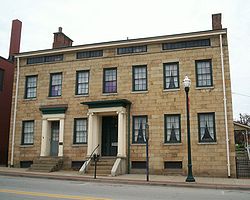
| 6 | David Bradford House David Bradford House David Bradford House, in Washington, Pennsylvania was the home of David Bradford, a leader of the Whiskey Rebellion.It is designated as a historic public landmark by the Washington County History & Landmarks Foundation.-History:... |
175 South Main Street 40°10′5"N 80°14′42"W |
Washington Washington, Pennsylvania Washington is a city in and the county seat of Washington County, Pennsylvania, United States, within the Pittsburgh Metro Area in the southwestern part of the state... |
|||
| 7 | Samuel Brownlee House Samuel Brownlee House Samuel Brownlee House is a historic building in Washington, Pennsylvania. It is designated as a historic residential landmark/farmstead by the Washington County History & Landmarks Foundation.-References:... |
North of Eighty-Four on Pennsylvania Route 519 Pennsylvania Route 519 Pennsylvania Route 519 runs in a north–south route through central Washington County connecting the Glyde area of North Bethlehem Township at the southern terminus with the Hickory area of Mt... 40°12′24"N 80°7′41"W |
North Strabane Township | |||
| 8 | Scott Brownlee Covered Bridge Scott Brownlee Covered Bridge Scott Brownlee Covered Bridge is a historic covered bridge in West Finley, Pennsylvania. It is designated as a historic bridge by the Washington County History & Landmarks Foundation.... |
Off Pennsylvania Route 231 Pennsylvania Route 231 Pennsylvania Route 231 is an long state highway located in Washington county in Pennsylvania. The southern terminus is at PA 18 near Old Concord. The northern terminus is at PA 50 in Avella.-Route description:... 40°2′38"N 80°23′53"W |
East Finley Township | |||
| 9 | Brownsville Bridge Brownsville Bridge The Brownsville Bridge, also known as the Intercounty Bridge, is a truss bridge that carries vehicular traffic across the Monongahela River between Brownsville, Pennsylvania and West Brownsville, Pennsylvania. The bridge was completed in 1914 to replace an 1831 wooden structure that was ill suited... |
State Route 4025 over the Monongahela River Monongahela River The Monongahela River is a river on the Allegheny Plateau in north-central West Virginia and southwestern Pennsylvania in the United States... 40°1′20"N 79°53′26"W |
West Brownsville West Brownsville, Pennsylvania West Brownsville is a borough in Washington County, Pennsylvania, United States. The population was 1,075 at the 2000 census.-Geography:West Brownsville is located at .... |
Extends into Fayette County | ||
| 10 | Caldwell Tavern Caldwell Tavern Caldwell Tavern is a historic building in Claysville, Pennsylvania. It is designated as a historic residential landmark/farmstead by the Washington County History & Landmarks Foundation.... |
Junction of U.S. Route 40 U.S. Route 40 U.S. Route 40 is an east–west United States highway. As with most routes whose numbers end in a zero, U.S. 40 once traversed the entire United States. It is one of the original 1920s U.S. Highways, and its first termini were San Francisco, California, and Atlantic City, New Jersey... and Township Route 474, northeast of Claysville 40°8′21"N 80°21′36"W |
Buffalo Township Buffalo Township, Washington County, Pennsylvania Buffalo Township is a township in Washington County, Pennsylvania, United States. The population was 2,100 at the 2000 census.-Geography:According to the United States Census Bureau, the township has a total area of , of which, of it is land and 0.05% is water.-Demographics:As of the census of... |
|||
| 11 | Canonsburg Armory Canonsburg Armory The Canonsburg Armory is a former Pennsylvania National Guard armory in Canonsburg, Pennsylvania. It was listed on the National Register of Historic Places on December 22, 1989.... |
West College Street and North Central Avenue 40°15′37.27"N 80°11′14.48"W |
Canonsburg Canonsburg, Pennsylvania Canonsburg is a borough in Washington County, Pennsylvania, southwest of Pittsburgh. Canonsburg was laid out by Colonel John Canon in 1789 and incorporated in 1802.... |
|||
| 12 | Cement City Historic District Cement City Historic District Cement City Historic District is a historic district in Donora, Pennsylvania.It is designated as a historic district by the Washington County History & Landmarks Foundation.... |
Roughly Chestnut and Walnut Streets from Modisette Avenue to Bertha Avenue and along Ida and Bertha Streets 40°10′15"N 79°51′56"W |
Donora Donora, Pennsylvania Donora is a borough in Washington County, Pennsylvania, south of Pittsburgh on the Monongahela river. Donora was incorporated in 1901. Donora got its name from a combination of William Donner and Nora Mellon, banker Andrew W. Mellon's wife. Agriculture, coal-mining, steel-making, wire-making, and... |
|||
| 13 | Centerville Historic District Centerville Historic District (Centerville, Pennsylvania) Centerville Historic District is a historic district in Centerville, Pennsylvania.It is designated as a historic district by the Washington County History & Landmarks Foundation.... |
Roughly Old National Pike from Linton Road to its junction with Pennsylvania Route 481 Pennsylvania Route 481 Pennsylvania Route 481 is an long state highway located in Washington county in Pennsylvania. The southern terminus is at US 40 in Centerville. The northern terminus is at PA 88/PA 136/PA 837 in Monongahela.-Route description:... 40°2′42"N 79°58′35"W |
Centerville Centerville, Washington County, Pennsylvania Centerville is a borough in Washington County, Pennsylvania, United States. The population was 3,390 at the 2000 census.-Geography:Centerville is located at .... |
|||
| 14 | Charleroi Historic District Charleroi Historic District Charleroi Historic District is a historic district in Charleroi, Pennsylvania.... |
Roughly bounded by 1st and 13th Streets, Oakland Avenue, and the former Pennsylvania Railroad Pennsylvania Railroad The Pennsylvania Railroad was an American Class I railroad, founded in 1846. Commonly referred to as the "Pennsy", the PRR was headquartered in Philadelphia, Pennsylvania.... tracks 40°8′24"N 79°54′0"W |
Charleroi Charleroi, Pennsylvania Charleroi is a borough in Washington County, Pennsylvania, along the Monongahela River, 25 miles south of Pittsburgh. Charleroi was settled in 1890 and incorporated in 1891. The population in 1900 stood at 5,930; in 1910, 9,615; in 1920, 11,516, and in 1940, 10,784... |
|||
| 15 | Charleroi-Monessen Bridge | State Route 2018 over the Monongahela River Monongahela River The Monongahela River is a river on the Allegheny Plateau in north-central West Virginia and southwestern Pennsylvania in the United States... 40°9′6"N 79°54′15"W |
North Charleroi North Charleroi, Pennsylvania North Charleroi is a borough in Washington County, Pennsylvania, United States. The population was 1,409 at the 2000 census.The city is also known as "Lock 4". Previously Lock and Dam #4 was located on this side of the Monongahela River, and the place had this name. Lock and Dam #4 was later... |
Extends into Monessen Monessen, Pennsylvania Monessen is a city in Westmoreland County, Pennsylvania, United States. The population was 8,669 at the 2000 census. In 1940, 20,257 people lived there. In 1990 the population was 13,026. Steel-making was a prominent industry in Monessen, which was a Rust Belt borough in the "Mon Valley" of... in Westmoreland County National Register of Historic Places listings in Westmoreland County, Pennsylvania This is a list of the National Register of Historic Places listings in Westmoreland County, Pennsylvania.This is intended to be a complete list of the properties and districts on the National Register of Historic Places in Westmoreland County, Pennsylvania, United States... |
||
| 16 | Crawford Covered Bridge Crawford Covered Bridge Crawford Covered Bridge is a historic Queen post truss covered bridge in West Finley, Pennsylvania. The 11'7" by 39' bridge has high sidewalls, a roof made of sheet metal, and crosswise planking. It is open to traffic across the Robinson Fork of Wheeling Creek.It is designated as a historic... |
Crawford Road spanning Robinson Fork Wheeling Creek Wheeling Creek (West Virginia) Wheeling Creek is a tributary of the Ohio River, 25 miles long, in the Northern Panhandle of West Virginia in the United States, with a watershed extending into southwestern Pennsylvania. Via the Ohio River, it is part of the watershed of the Mississippi River, draining an area of... 39°59′56"N 80°28′21"W |
West Finley Township | |||
| 17 | Dager-Wonsettler Farmstead Dager-Wonsettler Farmstead Dager-Wonsettler Farmstead is a historic building in Glyde, Pennsylvania. It is designated as a historic residential landmark/farmstead by the Washington County History & Landmarks Foundation.... |
1044 National Park, 0.5 mile (0.80467 km) northwest of the junction of Pennsylvania Route 519 Pennsylvania Route 519 Pennsylvania Route 519 runs in a north–south route through central Washington County connecting the Glyde area of North Bethlehem Township at the southern terminus with the Hickory area of Mt... and U.S. Route 40 U.S. Route 40 U.S. Route 40 is an east–west United States highway. As with most routes whose numbers end in a zero, U.S. 40 once traversed the entire United States. It is one of the original 1920s U.S. Highways, and its first termini were San Francisco, California, and Atlantic City, New Jersey... 40°7′49"N 80°8′51"W |
Amwell Township | |||
| 18 | Danley Covered Bridge Danley Covered Bridge Danley Covered Bridge is an historic Queen post truss covered bridge in West Finley, Pennsylvania.It is designated as a historic bridge by the Washington County History & Landmarks Foundation.... |
Dogwood Hill Road spanning Robinson Fork Wheeling Creek Wheeling Creek (West Virginia) Wheeling Creek is a tributary of the Ohio River, 25 miles long, in the Northern Panhandle of West Virginia in the United States, with a watershed extending into southwestern Pennsylvania. Via the Ohio River, it is part of the watershed of the Mississippi River, draining an area of... 40°3′18"N 80°26′22"W |
West Finley Township | |||
| 19 | Horn Davis Overholtzer Bridge Horn Davis Overholtzer Bridge Horn Davis Overholtzer Bridge is a historic covered bridge in North Fredericktown, Pennsylvania.It is designated as a historic bridge by the Washington County History & Landmarks Foundation.... |
Spanning Ten Mile Creek southeast of Fairfield 40°0′29"N 80°3′45"W |
West Bethlehem Township | Extends into Morgan Township in Greene County National Register of Historic Places listings in Greene County, Pennsylvania This is a list of the National Register of Historic Places listings in Greene County, Pennsylvania.This is intended to be a complete list of the properties and districts on National Register of Historic Places in Greene County, Pennsylvania, United States... |
||
| 20 | Day Covered Bridge Day Covered Bridge Day Covered Bridge is a historic Queen post truss covered bridge in Morris Township, Washington County, Pennsylvania. It is 12' by 36'6" and rests on three stone and mortar abutments. It was renovated in 2003, in a project that added steel support beams, a new roof, flooring and sidewalls.It is... |
_pa.jpg) |
Covered Bridge Road spanning Short Creek, south of Prosperity 40°1′46"N 80°17′35"W |
Morris Township Morris Township, Washington County, Pennsylvania Morris Township is a township in Washington County, Pennsylvania, United States. The population was 1,272 at the 2000 census.-Geography:According to the United States Census Bureau, the township has a total area of 28.4 square miles , of which, 28.4 square miles of it is land and... |
||
| 21 | Margaret Derrow House Margaret Derrow House Margaret Derrow House is a historic building in Claysville, Pennsylvania.It is designated as a historic residential landmark/farmstead by the Washington County History & Landmarks Foundation.-References:... |
West Main Street, west of the Claysville borough limits 40°6′56"N 80°24′59"W |
Donegal Township Donegal Township, Washington County, Pennsylvania Donegal Township is a township in Washington County, Pennsylvania, United States. The population was 2,428 at the 2000 census.-Geography:According to the United States Census Bureau, the township has a total area of , of which, of it is land and of it is water.-Demographics:As of the census of... |
|||
| 22 | Devil's Den, McClurg Covered Bridge Devil's Den, McClurg Covered Bridge Devil's Den, McClurg Covered Bridge is a historic King post truss covered bridge in Paris, Pennsylvania. The bridge crosses a small ravine in Hanover Township Park of the Old Stubenville Pike. It is only open to foot traffic. It is 12'3" wide and 24' long, with red vertical plank siding, three... |
Hanover Township park 40°25′28.52"N 80°26′47.51"W |
Hanover Township Hanover Township, Washington County, Pennsylvania Hanover Township is a township in Washington County, Pennsylvania, United States. The population was 2,795 at the 2000 census. Hillman State Park, a Pennsylvania state park and the First Niagara Pavilion concert venue are located in Hanover Township.... |
Moved from original location along King's Creek to Hanover Township park in 1987 | ||
| 23 | Doak-Little House Doak-Little House The Doak-Little House is a historic building in South Strabane Township, Pennsylvania.It is designated as a historic residential landmark/farmstead by the Washington County History & Landmarks Foundation.... |
U.S. Route 40 U.S. Route 40 U.S. Route 40 is an east–west United States highway. As with most routes whose numbers end in a zero, U.S. 40 once traversed the entire United States. It is one of the original 1920s U.S. Highways, and its first termini were San Francisco, California, and Atlantic City, New Jersey... 0.5 mile (0.80467 km) west of South Strabane 40°8′34"N 80°10′26"W |
South Strabane Township | |||
| 24 | Joseph Dorsey House Joseph Dorsey House Joseph Dorsey House is historic building in West Brownsville, Pennsylvania. It is designated as a historic residential landmark/farmstead by the Washington County History & Landmarks Foundation.-References:... |
113 Cherry Avenue, west of West Brownsville 40°1′14"N 79°55′24"W |
Centerville Centerville, Washington County, Pennsylvania Centerville is a borough in Washington County, Pennsylvania, United States. The population was 3,390 at the 2000 census.-Geography:Centerville is located at .... |
|||
| 25 | Dusmal House Dusmal House Dusmal House is a historic building in Gastonville, Pennsylvania.It is designated as a historic residential landmark/farmstead by the Washington County History & Landmarks Foundation.... |
East of Gastonville off Gilmore Road 40°15′10"N 79°57′55"W |
Union Township Union Township, Washington County, Pennsylvania Union Township is a township in Washington County, Pennsylvania, United States. The population was 5,599 at the 2000 census.-Geography:According to the United States Census Bureau, the township has a total area of 15.7 square miles , of which, 15.4 square miles of it is land and... |
|||
| 26 | East Washington Historic District East Washington Historic District The East Washington Historic District is a historic district in East Washington, Pennsylvania that is listed on the National Register of Historic Places... |
Roughly bounded by North, East, and Wade Avenues and Wheeling, Beau, and Chestnut Streets 40°10′18"N 80°14′4"W |
East Washington East Washington, Pennsylvania East Washington is a borough in Washington County, Pennsylvania, United States. The population was 1,930 at the 2000 census.-Geography:East Washington is located at .... |
|||
| 27 | Ebenezer Covered Bridge Ebenezer Covered Bridge Ebenezer Covered Bridge is a historic covered bridge in Ginger Hill, Pennsylvania.It is designated as a historic bridge by the Washington County History & Landmarks Foundation.... |
Mingo Creek County Park spanning Mingo Creek 40°11′28"N 80°2′28"W |
Nottingham Township | Moved from original location spanning South Fork Maple Creek at Ginger Hill in 1977 | ||
| 28 | Erskine Covered Bridge Erskine Covered Bridge Erskine Covered Bridge is a historic covered bridge in West Alexander, Pennsylvania.It is designated as a historic bridge by the Washington County History & Landmarks Foundation.... |
Erskine Road spanning Middle Wheeling Creek, south of West Alexander 40°3′59"N 80°30′59"W |
West Finley Township | |||
| 29 | First National Bank of Charleroi First National Bank of Charleroi First National Bank of Charleroi is a historic building in Charleroi, Pennsylvania. It was listed on the National Register of Historic Places on February 7, 2007.- History :... |
210 Fifth Street 40°8′25"N 79°53′52"W |
Charleroi Charleroi, Pennsylvania Charleroi is a borough in Washington County, Pennsylvania, along the Monongahela River, 25 miles south of Pittsburgh. Charleroi was settled in 1890 and incorporated in 1891. The population in 1900 stood at 5,930; in 1910, 9,615; in 1920, 11,516, and in 1940, 10,784... |
|||
| 30 | Molly Fleming House Molly Fleming House Molly Fleming House is a historic building in California, Pennsylvania.It is designated as a historic residential landmark/farmstead by the Washington County History & Landmarks Foundation.-References:... |
616 Wood Street 40°3′48"N 79°53′27.75"W |
California California, Pennsylvania California is a borough in Washington County, Pennsylvania, United States, along the Monongahela River. The population was 5,274 as of the 2000 census. California is the home of California University of Pennsylvania. Founded in 1849, the borough was named for the territory of California following... |
|||
| 31 | Philip Friend House Philip Friend House Philip Friend House is a historic building in North Bethlehem Township, Pennsylvania, USA.It is designated as a historic residential landmark/farmstead by the Washington County History & Landmarks Foundation.-References:... |
105 Little Daniels Run Road 40°4′14"N 80°7′31"W |
North Bethlehem Township | |||
| 32 | Harrison House Harrison House (Centerville, Pennsylvania) Harrison House is a historic building in Centerville, Pennsylvania.It is designated as a historic residential landmark/farmstead by the Washington County History & Landmarks Foundation.... |
Old Route 40 40°2′19"N 79°57′12"W |
Centerville Centerville, Washington County, Pennsylvania Centerville is a borough in Washington County, Pennsylvania, United States. The population was 3,390 at the 2000 census.-Geography:Centerville is located at .... |
|||
| 33 | Hawthorne School Hawthorne School (Canonsburg, Pennsylvania) The Hawthorne School was a historic, Tudor Revival school building in Canonsburg, Pennsylvania. It was listed on the National Register of Historic Places on May 8, 1986.... |
Hawthorne and Bluff Streets 40°15′37.63"N 80°11′47"W |
Canonsburg Canonsburg, Pennsylvania Canonsburg is a borough in Washington County, Pennsylvania, southwest of Pittsburgh. Canonsburg was laid out by Colonel John Canon in 1789 and incorporated in 1802.... |
|||
| 34 | Henry Covered Bridge Henry Covered Bridge (Pennsylvania) Henry Covered Bridge is a historic covered bridge in Monongahela, PennsylvaniaIt is designated as a historic bridge by the Washington County History & Landmarks Foundation.... |
Mansion Hill Road spanning Mingo Creek, west of Monongahela 40°12′8"N 80°1′1"W |
Nottingham Township | |||
| 35 | Hill's Tavern Hill's Tavern Hill's Tavern is a historic building in Scenery Hill, Pennsylvania.It is designated as a historic public landmark by the Washington County History & Landmarks Foundation.... |
U.S. Route 40 U.S. Route 40 U.S. Route 40 is an east–west United States highway. As with most routes whose numbers end in a zero, U.S. 40 once traversed the entire United States. It is one of the original 1920s U.S. Highways, and its first termini were San Francisco, California, and Atlantic City, New Jersey... in Scenery Hill 40°5′8"N 80°4′11"W |
North Bethlehem Township | |||
| 36 | Huffman Distillery and Chopping Mill Huffman Distillery and Chopping Mill Huffman Distillery and Chopping Mill is a historic building in Cokeburg, Pennsylvania.It is designated as a historic residential landmark/farmstead by the Washington County History & Landmarks Foundation.... |
Caldwell Road, 2 miles (3.2 km) north of the junction with Pennsylvania Route 917 Pennsylvania Route 917 Pennsylvania Route 917 is a long state highway located in Washington county in Pennsylvania. The southern terminus is at US 40 in North Bethlehem Township. The northern terminus is at PA 136 in Fallowfield Township.-Route description:... , north of Cokeburg 40°7′21"N 80°3′59"W |
Somerset Township Somerset Township, Washington County, Pennsylvania Somerset Township is a township in Washington County, Pennsylvania, United States. The population was 2,701 at the 2000 census.-Geography:... |
|||
| 37 | Hughes Covered Bridge Hughes Covered Bridge Hughes Covered Bridge is a historic covered bridge in Amwell Township, Washington County, Pennsylvania. Currently, it is used only for foot traffic. The Queenpost truss bridge is 12'4" wide and 55'6" long... |
Spans Ten Mile Creek, southeast of Prosperity 40°1′59"N 80°9′37"W |
Amwell Township | |||
| 38 | Jackson's Mill Covered Bridge Jackson's Mill Covered Bridge (Washington County, Pennsylvania) Jackson's Mill Covered Bridge is a historic covered bridge in Marianna, Pennsylvania.It is designated as a historic bridge by the Washington County History & Landmarks Foundation.... |
Kings Creek Road spanning Kings Creek, northwest of Burgettstown 40°25′26.08"N 80°29′21.3"W |
Hanover Township Hanover Township, Washington County, Pennsylvania Hanover Township is a township in Washington County, Pennsylvania, United States. The population was 2,795 at the 2000 census. Hillman State Park, a Pennsylvania state park and the First Niagara Pavilion concert venue are located in Hanover Township.... |
|||
| 39 | Jennings-Gallagher House Jennings-Gallagher House Jennings-Gallagher House is a historic building in California, Pennsylvania.It is designated as a historic residential landmark/farmstead by the Washington County History & Landmarks Foundation.... |
429 Wood Street 40°3′52"N 79°53′26"W |
California California, Pennsylvania California is a borough in Washington County, Pennsylvania, United States, along the Monongahela River. The population was 5,274 as of the 2000 census. California is the home of California University of Pennsylvania. Founded in 1849, the borough was named for the territory of California following... |
|||
| 40 | Kinder's Mill Kinder's Mill Kinder's Mill is a historic building in Deemston, Pennsylvania.It is designated as a historic residential landmark/farmstead by the Washington County History & Landmarks Foundation.... |
State Route 2011 at Piper Road 40°1′51"N 80°3′18"W |
Deemston Deemston, Pennsylvania Deemston is a borough in Washington County, Pennsylvania, United States. The population was 809 at the 2000 census.-Geography:Deemston is located at .... |
|||
| 41 | Krepps Covered Bridge Krepps Covered Bridge Krepps Covered Bridge is a historic covered bridge in Midway, Pennsylvania.It is designated as a historic bridge by the Washington County History & Landmarks Foundation.-References:... |
Covered Bridge Road, southeast of Cherry Valley and southwest of Midway 40°20′26"N 80°19′53"W |
Mount Pleasant Township Mount Pleasant Township, Washington County, Pennsylvania Mount Pleasant Township is a township in Washington County, Pennsylvania, in the United States. As of the 2000 census, the township population was 3,422.-Geography:... |
|||
| 42 | Leatherman Covered Bridge Leatherman Covered Bridge Leatherman Covered Bridge is a historic covered bridge in Cokeburg, Pennsylvania.It is designated as a historic bridge by the Washington County History & Landmarks Foundation.-References:... |
Leatherman Bridge Road, north of Cokeburg 40°6′33.25"N 80°4′18"W |
North Bethlehem Township | |||
| 43 | LeMoyne Crematory LeMoyne Crematory The LeMoyne Crematory was the first crematory in the United States. Francis Julius LeMoyne had it built in 1876, with the first cremation in world history being preformed on December 6, 1876.... |
Northwestern corner of the junction of Redstone Road and Elm Street, southeast of Washington 40°9′38"N 80°14′16"W |
North Franklin Township | |||
| 44 | F. Julius LeMoyne House F. Julius Lemoyne House F. Julius LeMoyne House is Georgian-style house built in 1812.It was declared a National Historic Landmark in 1997.The house is operated as a historic house museum by the Washington County Historical Society, which offers guided tours year round. The house contains period artifacts and is... |
 |
49 East Maiden Street 40°10′5"N 80°14′36"W |
Washington Washington, Pennsylvania Washington is a city in and the county seat of Washington County, Pennsylvania, United States, within the Pittsburgh Metro Area in the southwestern part of the state... |
||
| 45 | Moses Little Tavern Moses Little Tavern Moses Little Tavern is a historic building in Laboratory, Pennsylvania.It is designated as a historic residential landmark/farmstead by the Washington County History & Landmarks Foundation.... |
438 East National Pike, southeast of Laboratory 40°8′58"N 80°11′19"W |
Amwell Township | |||
| 46 | David Longwell House David Longwell House David Longwell House is a historic building in Monongahela, Pennsylvania.It is designated as a historic residential landmark/farmstead by the Washington County History & Landmarks Foundation.-References:... |
711 West Main Street 40°12′19"N 79°55′53"W |
Monongahela Monongahela, Pennsylvania Monongahela, colloquially called "Mon City," is a Third Class City in Washington County, Pennsylvania, United States and is part of the Pittsburgh Metro Area, located approximately south of the city proper. The population was 4,761 at the 2000 census... |
|||
| 47 | Lyle Covered Bridge Lyle Covered Bridge The Lyle Covered Bridge is a historic covered bridge in Raccoon, Pennsylvania.It is designated as a historic bridge by the Washington County History & Landmarks Foundation.-References:... |
Kramer Road spanning Brush Run, north of Raccoon 40°27′15.26"N 80°22′31.85"W |
Hanover Township Hanover Township, Washington County, Pennsylvania Hanover Township is a township in Washington County, Pennsylvania, United States. The population was 2,795 at the 2000 census. Hillman State Park, a Pennsylvania state park and the First Niagara Pavilion concert venue are located in Hanover Township.... |
|||
| 48 | Malden Inn Malden Inn Malden Inn is a historic building in Blainsburg, Pennsylvania.It is designated as a historic residential landmark/farmstead by the Washington County History & Landmarks Foundation.... |
West of Blainsburg on U.S. Route 40 U.S. Route 40 U.S. Route 40 is an east–west United States highway. As with most routes whose numbers end in a zero, U.S. 40 once traversed the entire United States. It is one of the original 1920s U.S. Highways, and its first termini were San Francisco, California, and Atlantic City, New Jersey... 40°2′15"N 79°55′50"W |
California California, Pennsylvania California is a borough in Washington County, Pennsylvania, United States, along the Monongahela River. The population was 5,274 as of the 2000 census. California is the home of California University of Pennsylvania. Founded in 1849, the borough was named for the territory of California following... |
|||
| 49 | Isaac Manchester House Isaac Manchester House Isaac Manchester House is a historic building in Avella, Pennsylvania.It is designated as a historic residential landmark/farmstead by the Washington County History & Landmarks Foundation.... |
2 miles (3.2 km) south of Avella on Pennsylvania Route 231 Pennsylvania Route 231 Pennsylvania Route 231 is an long state highway located in Washington county in Pennsylvania. The southern terminus is at PA 18 near Old Concord. The northern terminus is at PA 50 in Avella.-Route description:... 40°15′17"N 80°27′40"W |
Independence Township Independence Township, Washington County, Pennsylvania Independence Township is a township in Washington County, Pennsylvania, United States. The population was 1,676 at the 2000 census.-Geography:... |
|||
| 50 | Marianna Historic District Marianna Historic District (Marianna, Pennsylvania) Marianna Historic District is a historic district in Marianna, Pennsylvania.It is designated as a historic district by the Washington County History & Landmarks Foundation.... |
Roughly bounded by Ten Mile Creek, Beeson Avenue Hill, and 6th and 7th Streets 40°1′21"N 80°5′53"W |
Marianna Marianna, Pennsylvania Marianna is a borough in Washington County, Pennsylvania, United States. The population was 626 at the 2000 census.-History:Marianna was built as a mining town for the Pittsburg Buffalo Company in 1907 and was incorporated in 1910. At the time of its construction, the Marianna Mine was among the... |
|||
| 51 | Martin Farmstead Martin Farmstead The Martin Farmstead is a historic building in Washington, Pennsylvania.It is designated as a historic residential landmark/farmstead by the Washington County History & Landmarks Foundation.... |
Pennsylvania Route 136 Pennsylvania Route 136 Pennsylvania Route 136 is a long state highway located in Washington, Allegheny, and Westmoreland counties in Pennsylvania. The western terminus is at US 40 & PA 18 in Washington... , 2 miles (3.2 km) west of Eighty-Four 40°11′1"N 80°10′6"W |
South Strabane Township | |||
| 52 | Martin's Mill Covered Bridge Martin's Mill Covered Bridge (Marianna, Pennsylvania) Martin's Mill Covered Bridge is a historic covered bridge in Marianna, Pennsylvania.It is designated as a historic bridge by the Washington County History & Landmarks Foundation.... |
West of Marianna crossing Ten Mile Creek 40°0′49"N 80°7′54"W |
Amwell and West Bethlehem Townships | |||
| 53 | Dr. Joseph Maurer House Dr. Joseph Maurer House The Dr. Joseph Maurer House is a historic house in Washington, Pennsylvania.It is designated as a historic residential landmark/farmstead by the Washington County History & Landmarks Foundation.... |
97 West Wheeling Street 40°10′8.71"N 80°14′50.86"W |
Washington Washington, Pennsylvania Washington is a city in and the county seat of Washington County, Pennsylvania, United States, within the Pittsburgh Metro Area in the southwestern part of the state... |
|||
| 54 | Blaney Mays Covered Bridge Blaney Mays Covered Bridge Blaney Mays Covered Bridgeis a historic covered bridge in Claysville, PennsylvaniaIt is designated as a historic bridge by the Washington County History & Landmarks Foundation.-References:... |
Waynesburg Road spanning Middle Wheeling Creek, southwest of Claysville 40°5′17"N 80°29′15"W |
Donegal Township Donegal Township, Washington County, Pennsylvania Donegal Township is a township in Washington County, Pennsylvania, United States. The population was 2,428 at the 2000 census.-Geography:According to the United States Census Bureau, the township has a total area of , of which, of it is land and of it is water.-Demographics:As of the census of... |
|||
| 55 | Meadowcroft Rockshelter | West of Avella 40°17′11"N 80°29′30"W |
Jefferson Township Jefferson Township, Washington County, Pennsylvania Jefferson Township is a township in Washington County, Pennsylvania, United States. The population was 1,218 at the 2000 census.-Geography:... |
|||
| 56 | Longdon L. Miller Covered Bridge Longdon L. Miller Covered Bridge Longdon L. Miller Covered Bridge is a historic covered bridge in West Finley, Pennsylvania.It is designated as a historic bridge by the Washington County History & Landmarks Foundation.-References:... |
Miller Creek Road spanning Templeton Fork Wheeling Creek Wheeling Creek (West Virginia) Wheeling Creek is a tributary of the Ohio River, 25 miles long, in the Northern Panhandle of West Virginia in the United States, with a watershed extending into southwestern Pennsylvania. Via the Ohio River, it is part of the watershed of the Mississippi River, draining an area of... , west of Enon 39°58′41"N 80°26′47"W |
West Finley Township | |||
| 57 | Mingo Creek Presbyterian Church and Churchyard Mingo Creek Presbyterian Church and Churchyard Mingo Creek Presbyterian Church and Churchyard is a historic church in Courtney, Pennsylvania.It was built in 1793 and added to the National Register of Historic Places in 1992.... |
Junction of Pennsylvania Route 88 Pennsylvania Route 88 Pennsylvania Route 88 is a long north–south state highway located in southwestern Pennsylvania. The southern terminus of the route is at U.S. Route 119 in Point Marion less than from the Pennsylvania-West Virginia border. The northern terminus is at Pennsylvania Route 51 in Pittsburgh... and Mingo Church Road, northwest of Courtney 40°13′44"N 79°59′50"W |
Union Township Union Township, Washington County, Pennsylvania Union Township is a township in Washington County, Pennsylvania, United States. The population was 5,599 at the 2000 census.-Geography:According to the United States Census Bureau, the township has a total area of 15.7 square miles , of which, 15.4 square miles of it is land and... |
|||
| 58 | Monongahela Cemetery Monongahela Cemetery Monongahela Cemetery is a historic cemetery in Monongahela City, Pennsylvania, established in 1863.-Notable interments:*Robert Grant Furlong , US Congressman*Baptiste "Bap" Manzini , professional football player-External links:*... |
Cemetery Hill Road at Gregg Street 40°11′39"N 79°55′20"W |
Monongahela Monongahela, Pennsylvania Monongahela, colloquially called "Mon City," is a Third Class City in Washington County, Pennsylvania, United States and is part of the Pittsburgh Metro Area, located approximately south of the city proper. The population was 4,761 at the 2000 census... |
|||
| 59 | Montgomery House Montgomery House (Claysville, Pennsylvania) Montgomery House is a historic building in Claysville, Pennsylvania.It is designated as a historic residential landmark/farmstead by the Washington County History & Landmarks Foundation.... |
West Main Street 40°6′57"N 80°24′58"W |
Claysville Claysville, Pennsylvania Claysville is a borough in Washington County, Pennsylvania, United States. The population was 724 at the 2000 census. Claysville Elementary School, part of the McGuffey School District is located in Claysville.... |
|||
| 60 | Thomas Munce House Thomas Munce House Thomas Munce House is a historic building in Washington, Pennsylvania.It is designated as a historic residential landmark/farmstead by the Washington County History & Landmarks Foundation.-References:... |
Pennsylvania Route 136 Pennsylvania Route 136 Pennsylvania Route 136 is a long state highway located in Washington, Allegheny, and Westmoreland counties in Pennsylvania. The western terminus is at US 40 & PA 18 in Washington... , 3 miles (4.8 km) east of Washington 40°11′13"N 80°10′48"W |
South Strabane Township | |||
| 61 | John H. Nelson House John H. Nelson House John H. Nelson House is a historic building in Fallowfield, Pennsylvania.It is designated as a historic residential landmark/farmstead by the Washington County History & Landmarks Foundation.-References:... |
104 Colvin Road 40°8′4"N 79°57′28"W |
Fallowfield Township | |||
| 62 | Old Main, California State College | 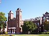 |
California State College California University of Pennsylvania California University of Pennsylvania is a public university located in California, Pennsylvania, USA. Founded in 1852, it is a member of the Pennsylvania State System of Higher Education. Cal U's enrollment is approximately 9,400.The main campus consists of about 38 buildings situated on 92 acres... campus 40°3′57"N 79°53′8"W |
California California, Pennsylvania California is a borough in Washington County, Pennsylvania, United States, along the Monongahela River. The population was 5,274 as of the 2000 census. California is the home of California University of Pennsylvania. Founded in 1849, the borough was named for the territory of California following... |
||
| 63 | Robert Parkinson Farm Robert Parkinson Farm Robert Parkinson Farm is a historic building in Morris Township, Pennsylvania.It is designated as a historic residential landmark/farmstead by the Washington County History & Landmarks Foundation.... |
Pennsylvania Route 18 Pennsylvania Route 18 Pennsylvania Route 18 is a major north–south highway in Western Pennsylvania whose southern terminus is at the West Virginia state line in Greene County, Pennsylvania near the village of Garrison, while the northern terminus is at PA Route 5 in Lake City, Pennsylvania... , 0.4 mile (0.643736 km) north of Old Concord 40°0′44"N 80°20′0"W |
Morris Township Morris Township, Washington County, Pennsylvania Morris Township is a township in Washington County, Pennsylvania, United States. The population was 1,272 at the 2000 census.-Geography:According to the United States Census Bureau, the township has a total area of 28.4 square miles , of which, 28.4 square miles of it is land and... |
|||
| 64 | Pennsylvania Railroad Freight Station Pennsylvania Railroad Freight Station (Washington, Pennsylvania) The Pennsylvania Railroad Freight Station, also called the Chartiers Valley Railway Freight Station, is a historic, former train station building in Washington, Pennsylvania... |
111 Washington Street 40°10′20"N 80°15′15"W |
Washington Washington, Pennsylvania Washington is a city in and the county seat of Washington County, Pennsylvania, United States, within the Pittsburgh Metro Area in the southwestern part of the state... |
|||
| 65 | Pennsylvania Railroad Passenger Station California Area Public Library The California Area Public Library is the public library serving California, Pennsylvania and is a branch of the Washington County Library System... |
100 Wood Street 40°4′5"N 79°53′21"W |
California California, Pennsylvania California is a borough in Washington County, Pennsylvania, United States, along the Monongahela River. The population was 5,274 as of the 2000 census. California is the home of California University of Pennsylvania. Founded in 1849, the borough was named for the territory of California following... |
|||
| 66 | Pine Bank Covered Bridge Pine Bank Covered Bridge Pine Bank Covered Bridge is a historic covered bridge in Studa, Pennsylvania.It is designated as a historic bridge by the Washington County History & Landmarks Foundation.-References:... |
Meadowcroft Rockshelter and Museum of Rural Life, southwest of Studa crossing a ravine 40°17′20"N 80°29′27"W |
Jefferson Township Jefferson Township, Washington County, Pennsylvania Jefferson Township is a township in Washington County, Pennsylvania, United States. The population was 1,218 at the 2000 census.-Geography:... |
|||
| 67 | Plant's Covered Bridge Plant's Covered Bridge Plant's Covered Bridge is a historic covered bridge in West Finley, Pennsylvania.It is designated as a historic bridge by the Washington County History & Landmarks Foundation.-References:... |
Skyview Road spanning Templeton Fork Wheeling Creek 40°1′16"N 80°24′58"W |
East Finley Township | |||
| 68 | Ralston Freeman Covered Bridge Ralston Freeman Covered Bridge Ralston Freeman Covered Bridge is a historic covered bridge in Paris, Pennsylvania.It is designated as a historic bridge by the Washington County History & Landmarks Foundation.-References:... |
North of Paris crossing Aunt Clara's Fork of King's Creek 40°26′49.19"N 80°30′25.64"W |
Hanover Township Hanover Township, Washington County, Pennsylvania Hanover Township is a township in Washington County, Pennsylvania, United States. The population was 2,795 at the 2000 census. Hillman State Park, a Pennsylvania state park and the First Niagara Pavilion concert venue are located in Hanover Township.... |
|||
| 69 | Regester Log House Regester Log House Regester Log House is a historic building in Fredericktown, Pennsylvania.It is designated as a historic residential landmark/farmstead by the Washington County History & Landmarks Foundation.... |
North of Fredericktown off Pennsylvania Route 88 Pennsylvania Route 88 Pennsylvania Route 88 is a long north–south state highway located in southwestern Pennsylvania. The southern terminus of the route is at U.S. Route 119 in Point Marion less than from the Pennsylvania-West Virginia border. The northern terminus is at Pennsylvania Route 51 in Pittsburgh... 40°0′43"N 79°59′47"W |
East Bethlehem Township | |||
| 70 | Ringland Tavern Ringland Tavern Ringland Tavern is a historic building in Scenery Hill, Pennsylvania.It is designated as a historic residential landmark/farmstead by the Washington County History & Landmarks Foundation.... |
U.S. Route 40 U.S. Route 40 U.S. Route 40 is an east–west United States highway. As with most routes whose numbers end in a zero, U.S. 40 once traversed the entire United States. It is one of the original 1920s U.S. Highways, and its first termini were San Francisco, California, and Atlantic City, New Jersey... in Scenery Hill 40°5′3"N 80°4′6"W |
North Bethlehem Township | |||
| 71 | Roberts House Roberts House (Canonsburg, Pennsylvania) The Roberts House is a historic building in Canonsburg, Pennsylvania.It is designated as a historic residential landmark/farmstead by the Washington County History & Landmarks Foundation.... |
225 North Central Avenue 40°15′40.1"N 80°11′14.83"W |
Canonsburg Canonsburg, Pennsylvania Canonsburg is a borough in Washington County, Pennsylvania, southwest of Pittsburgh. Canonsburg was laid out by Colonel John Canon in 1789 and incorporated in 1802.... |
|||
| 72 | Frank L. Ross Farm Frank L. Ross Farm Frank L. Ross Farm is a historic building in North Bethlehem Township, Pennsylvania.It is designated as a historic residential landmark/farmstead by the Washington County History & Landmarks Foundation.... |
Pennsylvania Route 519 Pennsylvania Route 519 Pennsylvania Route 519 runs in a north–south route through central Washington County connecting the Glyde area of North Bethlehem Township at the southern terminus with the Hickory area of Mt... , 0.3 mile (0.482802 km) north of U.S. Route 40 U.S. Route 40 U.S. Route 40 is an east–west United States highway. As with most routes whose numbers end in a zero, U.S. 40 once traversed the entire United States. It is one of the original 1920s U.S. Highways, and its first termini were San Francisco, California, and Atlantic City, New Jersey... 40°7′56"N 80°8′1"W |
North Bethlehem and South Strabane Townships | |||
| 73 | "S" Bridge Claysville S Bridge The Claysville "S" Bridge is a historic S bridge in Washington County, Pennsylvania.It is designated as a historic bridge by the Washington County History & Landmarks Foundation.... |
U.S. Route 40 U.S. Route 40 U.S. Route 40 is an east–west United States highway. As with most routes whose numbers end in a zero, U.S. 40 once traversed the entire United States. It is one of the original 1920s U.S. Highways, and its first termini were San Francisco, California, and Atlantic City, New Jersey... at Pennsylvania Route 221 Pennsylvania Route 221 Pennsylvania Route 221 is an long state highway located in Greene and Washington counties in Pennsylvania. The southern terminus is at PA 188 near Jefferson. The northern terminus is at PA 231 in Acheson.-Greene County:... , 6 miles (9.7 km) west of Washington 40°8′22"N 80°21′0"W |
Buffalo Township Buffalo Township, Washington County, Pennsylvania Buffalo Township is a township in Washington County, Pennsylvania, United States. The population was 2,100 at the 2000 census.-Geography:According to the United States Census Bureau, the township has a total area of , of which, of it is land and 0.05% is water.-Demographics:As of the census of... |
|||
| 74 | Sawhill Covered Bridge Sawhill Covered Bridge Sawhill Covered Bridge is a historic covered bridge in Taylorstown, Pennsylvania.It is designated as a historic bridge by the Washington County History & Landmarks Foundation.-References:... |
Off Pennsylvania Route 221 Pennsylvania Route 221 Pennsylvania Route 221 is an long state highway located in Greene and Washington counties in Pennsylvania. The southern terminus is at PA 188 near Jefferson. The northern terminus is at PA 231 in Acheson.-Greene County:... , northwest of Taylorstown 40°10′48"N 80°24′59"W |
Blaine Township | |||
| 75 | Scenery Hill Historic District Scenery Hill Historic District Scenery Hill Historic District is a historic district in Scenery Hill, Pennsylvania.It is designated as a historic district by the Washington County History & Landmarks Foundation.... |
Roughly National Pike East/U.S. Route 40 U.S. Route 40 U.S. Route 40 is an east–west United States highway. As with most routes whose numbers end in a zero, U.S. 40 once traversed the entire United States. It is one of the original 1920s U.S. Highways, and its first termini were San Francisco, California, and Atlantic City, New Jersey... between Scenery Hill Cemetery and Kinder Road in Scenery Hill 40°5′8"N 80°4′17"W |
North Bethlehem Township | |||
| 76 | Sprowl's Covered Bridge Sprowl's Covered Bridge Sprowl's Covered Bridge is a historic covered bridge in West Finley, Pennsylvania.It is designated as a historic bridge by the Washington County History & Landmarks Foundation.-References:... |
Off Pennsylvania Route 231 Pennsylvania Route 231 Pennsylvania Route 231 is an long state highway located in Washington county in Pennsylvania. The southern terminus is at PA 18 near Old Concord. The northern terminus is at PA 50 in Avella.-Route description:... 40°0′39"N 80°24′25"W |
East Finley Township | |||
| 77 | Stephenson-Campbell House Stephenson-Campbell House Stephenson-Campbell House is a historic building in Cecil, Pennsylvania.It is designated as a historic residential landmark/farmstead by the Washington County History & Landmarks Foundation.... |
At the end of Tomahawk Claim Lane, off Reissing Road 40°20′31"N 80°11′43"W |
Cecil Township | |||
| 78 | Taylorstown Historic District Taylorstown Historic District (Taylorstown, Pennsylvania) Taylorstown Historic District is a historic district in Taylorstown, Pennsylvania.It is designated as a historic district by the Washington County History & Landmarks Foundation.... |
Main Street in Taylorstown 40°9′35"N 80°22′45"W |
Blaine Township | |||
| 79 | James Thome Farm James Thome Farm James Thome Farm is a historic building in Eighty Four, Pennsylvania.It is designated as a historic residential landmark/farmstead by the Washington County History & Landmarks Foundation.... |
213 Linnwood Road, northwest of Eighty Four 40°11′53"N 80°9′30"W |
North Strabane Township | |||
| 80 | Trinity Hall | 1 miles (1.6 km) south of Washington on Pennsylvania Route 18 Pennsylvania Route 18 Pennsylvania Route 18 is a major north–south highway in Western Pennsylvania whose southern terminus is at the West Virginia state line in Greene County, Pennsylvania near the village of Garrison, while the northern terminus is at PA Route 5 in Lake City, Pennsylvania... 40°9′53"N 80°14′56"W |
North Franklin Township | |||
| 81 | Ulery Mill Ulery Mill Ulery Mill is a historic building in Marianna, Pennsylvania.It is designated as a historic residential landmark/farmstead by the Washington County History & Landmarks Foundation.... |
Southeast of Marianna 40°0′40"N 80°4′32"W |
West Bethlehem Township | |||
| 82 | US Post Office-Charleroi | 638 Fallowfield Avenue 40°8′24"N 79°54′2"W |
Charleroi Charleroi, Pennsylvania Charleroi is a borough in Washington County, Pennsylvania, along the Monongahela River, 25 miles south of Pittsburgh. Charleroi was settled in 1890 and incorporated in 1891. The population in 1900 stood at 5,930; in 1910, 9,615; in 1920, 11,516, and in 1940, 10,784... |
|||
| 83 | Washington Armory Washington Armory The Washington Armory is a former Pennsylvania National Guard armory in Washington, Pennsylvania. It was listed on the National Register of Historic Places on May 9, 1991.... |
76 West Maiden Street 40°10′2.23"N 80°14′47.36"W |
Washington Washington, Pennsylvania Washington is a city in and the county seat of Washington County, Pennsylvania, United States, within the Pittsburgh Metro Area in the southwestern part of the state... |
|||
| 84 | Washington County Courthouse Washington County Courthouse (Pennsylvania) The Washington County Courthouse is located in on Main Street in downtown Washington, Pennsylvania and is currently still in operation.It was listed on the National Register of Historic Places on July 30, 1974.... |
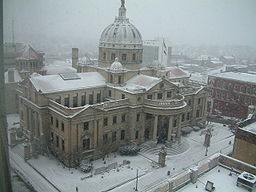 |
South Main Street 40°10′13.62"N 80°14′44.89"W |
Washington Washington, Pennsylvania Washington is a city in and the county seat of Washington County, Pennsylvania, United States, within the Pittsburgh Metro Area in the southwestern part of the state... |
||
| 85 | Washington County Jail Washington County Jail (Washington, Pennsylvania) The Washington County Jail is located on Cherry Street, beside the courthouse, in downtown Washington, Pennsylvania.It was listed on the National Register of Historic Places on July 30, 1974... |
Cherry Street 40°10′12.85"N 80°14′46.78"W |
Washington Washington, Pennsylvania Washington is a city in and the county seat of Washington County, Pennsylvania, United States, within the Pittsburgh Metro Area in the southwestern part of the state... |
|||
| 86 | Webster Donora Bridge | State Route 1022 over the Monongahela River Monongahela River The Monongahela River is a river on the Allegheny Plateau in north-central West Virginia and southwestern Pennsylvania in the United States... 40°11′3"N 79°51′8"W |
Donora Donora, Pennsylvania Donora is a borough in Washington County, Pennsylvania, south of Pittsburgh on the Monongahela river. Donora was incorporated in 1901. Donora got its name from a combination of William Donner and Nora Mellon, banker Andrew W. Mellon's wife. Agriculture, coal-mining, steel-making, wire-making, and... |
Extends into Rostraver Township in Westmoreland County National Register of Historic Places listings in Westmoreland County, Pennsylvania This is a list of the National Register of Historic Places listings in Westmoreland County, Pennsylvania.This is intended to be a complete list of the properties and districts on the National Register of Historic Places in Westmoreland County, Pennsylvania, United States... |
||
| 87 | Welsh-Emery House Welsh-Emery House Welsh-Emery House is a historic building in Richeyville, Pennsylvania.It is designated as a historic residential landmark/farmstead by the Washington County History & Landmarks Foundation.... |
114 Emery Road 40°2′58"N 80°0′4"W |
Centerville Centerville, Washington County, Pennsylvania Centerville is a borough in Washington County, Pennsylvania, United States. The population was 3,390 at the 2000 census.-Geography:Centerville is located at .... |
|||
| 88 | West Alexander Historic District West Alexander Historic District West Alexander Historic District is a historic district in West Alexander, Pennsylvania.It is designated as a historic district by the Washington County History & Landmarks Foundation.... |
Roughly bounded by Main, North Liberty, and Mechanic Streets in West Alexander 40°6′15"N 80°30′37"W |
Donegal Township Donegal Township, Washington County, Pennsylvania Donegal Township is a township in Washington County, Pennsylvania, United States. The population was 2,428 at the 2000 census.-Geography:According to the United States Census Bureau, the township has a total area of , of which, of it is land and of it is water.-Demographics:As of the census of... |
|||
| 89 | West Middletown Historic District West Middletown Historic District West Middletown Historic District is a historic district in West Middletown, Pennsylvania.It is designated as a historic district by the Washington County History & Landmarks Foundation.... |
Main Street 40°14′34"N 80°25′34"W |
West Middletown West Middletown, Pennsylvania West Middletown is a borough in Washington County, Pennsylvania, United States. The population was 144 at the 2000 census.-Geography:West Middletown is located at .... |
|||
| 90 | John White House John White House (Chartiers Township, Pennsylvania) John White House is a historic building in Chartiers Township, Pennsylvania.It is designated as a historic residential landmark/farmstead by the Washington County History & Landmarks Foundation.-References:... |
2151 North Main Street Extension 40°12′28"N 80°15′25"W |
Chartiers Township | |||
| 91 | Wilson's Mill Covered Bridge Wilson's Mill Covered Bridge Wilson's Mill Covered Bridge is a historic covered bridge in Avella, Pennsylvania.It is designated as a historic bridge by the Washington County History & Landmarks Foundation.-References:... |
Oakleaf Road spanning Cross Creek, southeast of Avella 40°15′32.4"N 80°22′39.6"W |
Cross Creek and Hopewell Hopewell Township, Washington County, Pennsylvania Hopewell Township is a township in Washington County, Pennsylvania, United States. The population was 992 at the 2000 census.-Geography:According to the United States Census Bureau, the township has a total area of , all of it land.-Demographics:... Townships |
|||
| 92 | Levi Wilson Tavern Levi Wilson Tavern Levi Wilson Tavern is a historic building in Buffalo Township, PennsylvaniaIt is designated as a historic residential landmark/farmstead by the Washington County History & Landmarks Foundation.... |
U.S. Route 40 U.S. Route 40 U.S. Route 40 is an east–west United States highway. As with most routes whose numbers end in a zero, U.S. 40 once traversed the entire United States. It is one of the original 1920s U.S. Highways, and its first termini were San Francisco, California, and Atlantic City, New Jersey... , 1.5 miles (2.4 km) east of the S Bridge 40°9′0"N 80°19′44"W |
Buffalo Township Buffalo Township, Washington County, Pennsylvania Buffalo Township is a township in Washington County, Pennsylvania, United States. The population was 2,100 at the 2000 census.-Geography:According to the United States Census Bureau, the township has a total area of , of which, of it is land and 0.05% is water.-Demographics:As of the census of... |
|||
| 93 | Cerl Wright Covered Bridge Cerl Wright Covered Bridge Cerl Wright Covered Bridge is a historic covered bridge in Bentleyville, Pennsylvania.It is designated as a historic bridge by the Washington County History & Landmarks Foundation.-References:... |
Ridge Road, northwest of Bentleyville crossing North Fork of Pigeon Creek 40°9′32"N 80°2′56"W |
Somerset Township Somerset Township, Washington County, Pennsylvania Somerset Township is a township in Washington County, Pennsylvania, United States. The population was 2,701 at the 2000 census.-Geography:... |
|||
| 94 | Enoch Wright House Enoch Wright House -References:... |
815 Venetia Road 40°14′59"N 80°1′44"W |
Peters Township Peters Township, Washington County, Pennsylvania Peters Township is a township in Washington County, Pennsylvania, United States. The population was 17,566 at the 2000 census.-Geography:... |
|||
| 95 | Wyit Sprowls Covered Bridge Wyit Sprowls Covered Bridge Wyit Sprowls Covered Bridge is a covered bridge in West Finley, Pennsylvania.It is designated as a historic bridge by the Washington County History & Landmarks Foundation.-References:... |
East Finley Township park spanning Robinson Fork Wheeling Creek 40°2′22"N 80°24′6"W |
East Finley Township | Relocated to current location from West Finley Township approximately 1996 |
Former listing
| Landmark name | Image | Date delisted | Location | City or Town | Summary | |
|---|---|---|---|---|---|---|
| 1 | Sackville House Sackville House The Sackville House was a historic building in Washington, PennsylvaniaIt is designated as a historic residential landmark/farmstead by the Washington County History & Landmarks Foundation.... |
309 East Wheeling Street 40°10′13"N 80°14′21"W |
Washington Washington, Pennsylvania Washington is a city in and the county seat of Washington County, Pennsylvania, United States, within the Pittsburgh Metro Area in the southwestern part of the state... |
Listed on |
See also
- List of National Historic Landmarks in Pennsylvania
- National Register of Historic Places listings in Pennsylvania
- List of Pennsylvania state historical markers in Washington County
- Washington County History & Landmarks FoundationWashington County History & Landmarks FoundationWashington County History & Landmarks Foundation is a non-profit educational institution in Washington, Pennsylvania. Its purpose is to encourage and assist the preservation of historic structures in Washington County, Pennsylvania...