

List of Pennsylvania state historical markers in Huntingdon County
Encyclopedia
This is intended to be a complete list of the official state historical markers placed in Huntingdon County, Pennsylvania
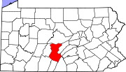
Huntingdon County, Pennsylvania
Huntingdon County is a county located in the U.S. state of Pennsylvania. In 2010, its population was 45,913.Huntingdon County was created on September 20, 1787, from part of Bedford County. Its county seat is Huntingdon.-Geography:According to the U.S...
by the Pennsylvania Historical and Museum Commission
Pennsylvania Historical and Museum Commission
The Pennsylvania Historical and Museum Commission is the governmental agency of the Commonwealth of Pennsylvania responsible for the collection, conservation and interpretation of Pennsylvania's historic heritage...
(PHMC). The locations of the historical markers, as well as the latitude and longitude coordinates as provided by the PHMC's database, are included below when available. There are 23 historical markers located in Huntingdon County.
Historical markers
| Marker title | Image | Date dedicated | Location | Marker type | Topics |
|---|---|---|---|---|---|
| Admiral Wm. Sims William Sims William Sowden Sims was an admiral in the United States Navy who sought during the late 19th and early 20th centuries to modernize the Navy. During World War I he commanded all United States naval forces operating in Europe... |
 |
Pa. 994 in Rockville, W of U.S. 522 40.2382°N 77.90167°W |
Roadside | Military, Military Post-Civil War | |
| Bedford Furnace | US 522, at SE end of Orbisonia °N °W |
Roadside | Business & Industry, Coal, Furnaces, Iron | ||
| Coleraine Forges | Pa. 45, 1.6 miles NE of Spruce Creek 40.6272°N 78.11406°W |
Roadside | Business & Industry, Coal, Iron | ||
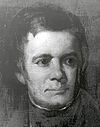
| David R. Porter David R. Porter David Rittenhouse Porter was the ninth Governor of Pennsylvania. He served from 1839 to 1845.-Life:Porter, the first governor under the State Constitution of 1838 was born October 31, 1788, near Norristown, Montgomery County, Pennsylvania spending his boyhood at Selma Mansion, a home built by his... |
 |
3rd & Penn Sts., Huntingdon 40.48378°N 78.00891°W |
City | Government & Politics, Government & Politics 19th Century, Governors, Professions & Vocations | |
| Fort Roberdeau Fort Roberdeau Fort Roberdeau, also known as The Lead Mine Fort, is a historic fort located near Culp, Blair County, Pennsylvania. It was built in 1777, and reconstructed in 1939-1941, by concerned local agencies with support from the National Youth Administration. It is a square structure with blockhouse-like... |
Pa. 453 & Truck Pa. 45 just S of Union Furnace (MISSING) 40.60975°N 78.16875°W |
Roadside | American Revolution, Forts, Military | ||
| Fort Shirley Fort Shirley Fort Shirley was a fort erected by the Province of Pennsylvania during the French and Indian War.-History:During the mid-1750s, the mountainous ridges and valleys of south central Pennsylvania were an important theater for colliding European and Native American cultures... |
U.S. 522 at N end Shirleysburg 40.30174°N 77.87404°W |
Roadside | Forts, French & Indian War, Military | ||
| Fort Shirley - PLAQUE | US 522, Shirleysburg 40.30131°N 77.87431°W |
Plaque | Forts, French & Indian War, Military | ||
| Fort Standing Stone | Penn St., Huntingdon 40.48162°N 78.00411°W |
Roadside | American Revolution, Forts, Military, Native American | ||
| Frankstown Path | US 22 at Water Street, PA (town name) 40.57096°N 78.13425°W |
Roadside | Paths & Trails, Transportation | ||
| Greenwood Furnace Greenwood Furnace State Park Greenwood Furnace State Park is a Pennsylvania state park in Jackson Township, Huntingdon County, Pennsylvania in the United States. The park is near the historic iron making center of Greenwood Furnace. The park includes the ghost town of Greenwood that grew up around the ironworks, old roads and... |
Pa. 305 at Greenwood Furnace State Park 40.64903°N 77.75705°W |
Roadside | Business & Industry, Furnaces, Iron | ||
| Hart's Log Alexandria, Pennsylvania Alexandria is a borough in Huntingdon County, Pennsylvania, United States. The population was 401 at the 2000 census.-Geography:According to the United States Census Bureau, the borough has a total area of , all of it land.-Demographics:... |
PA 305 at US22 junction, just S of Alexandria 40.55737°N 78.0993°W |
Roadside | Early Settlement, Paths & Trails, Professions & Vocations, Transportation | ||
| Huntingdon County Huntingdon County, Pennsylvania Huntingdon County is a county located in the U.S. state of Pennsylvania. In 2010, its population was 45,913.Huntingdon County was created on September 20, 1787, from part of Bedford County. Its county seat is Huntingdon.-Geography:According to the U.S... |
County Courthouse, Penn St., Huntingdon 40.48364°N 78.00813°W |
City | Government & Politics, Government & Politics 18th Century | ||
| Jack's Narrows | U.S. 22, 8.5 miles SE of Huntingdo (Missing) °N °W |
Roadside | Environment | ||
| Juniata Iron | U.S. 522, 1 mile S of Orbisonia °N °W |
Roadside | Business & Industry, Coal, Iron | ||
| Juniata Iron | U.S. 22 just E of Water Street 40.57088°N 78.13396°W |
Roadside | Business & Industry, Coal, Iron | ||
| Martin G. Brumbaugh | Pa. 26, 1.3 miles NE of Marklesburg 40.39705°N 78.1488°W |
Roadside | Education, Government & Politics, Government & Politics 20th Century, Governors | ||
| Martin G. Brumbaugh | US 22 & PA 26, W of Huntingdon 40.49208°N 78.04007°W |
Roadside | Education, Governors, Professions & Vocations | ||
| McAlevy's Fort | n/a | Junction Pa. 305 & Pa. 545 at McAlevy's Fort (Missing) °N °W |
Roadside | American Revolution, Military | |
| McMurtrie Mansion | 4th & Penn. Huntingdon 40.48447°N 78.01069°W |
City | Buildings, Mansions & Manors | ||
| Pennsylvania Furnace | Spruce Creek Rd. (PA 45) at Pennsylvania Furnace Rd., PA Furnace 40.70172°N 77.99935°W |
Roadside | Business & Industry, Coal, Furnaces, Iron | ||
| Rural Electrification Rural electrification Rural electrification is the process of bringing electrical power to rural and remote areas. Electricity is used not only for lighting and household purposes, but it also allows for mechanization of many farming operations, such as threshing, milking, and hoisting grain for storage; in areas... |
10700 Fairgrounds Rd., Huntingdon 40.5094°N 77.97878°W |
Roadside | Business & Industry, Electricity | ||
| Shadow of Death | Croghan Pike (US 522) W of Shade Gap 40.18869°N 77.87561°W |
Roadside | Paths & Trails, Transportation | ||
| Spruce Creek Church | Spruce Creek Rd. (PA 45) at church, just NE of Graysville 40.69087°N 78.288°W |
Roadside | Religion |
See also
- List of Pennsylvania state historical markers
- National Register of Historic Places listings in Huntingdon County, PennsylvaniaNational Register of Historic Places listings in Huntingdon County, PennsylvaniaThis is a list of the National Register of Historic Places listings in Huntingdon County, Pennsylvania.This is intended to be a complete list of the properties and districts on the National Register of Historic Places in Huntingdon County, Pennsylvania, United States...