

List of Pennsylvania state historical markers in Clinton County
Encyclopedia
This is intended to be a complete list of the official state historical markers placed in Clinton County, Pennsylvania
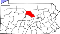
Clinton County, Pennsylvania
As of the census of 2000, there were 37,914 people, 14,773 households, and 9,927 families residing in the county. The population density was 43 people per square mile . There were 18,166 housing units at an average density of 20 per square mile...
by the Pennsylvania Historical and Museum Commission
Pennsylvania Historical and Museum Commission
The Pennsylvania Historical and Museum Commission is the governmental agency of the Commonwealth of Pennsylvania responsible for the collection, conservation and interpretation of Pennsylvania's historic heritage...
(PHMC). The locations of the historical markers, as well as the latitude and longitude coordinates as provided by the PHMC's database, are included below when available. There are 12 historical markers located in Clinton County.
Historical markers
| Marker title | Image | Date dedicated | Location | Marker type | Topics |
|---|---|---|---|---|---|
| Clinton County Clinton County, Pennsylvania As of the census of 2000, there were 37,914 people, 14,773 households, and 9,927 families residing in the county. The population density was 43 people per square mile . There were 18,166 housing units at an average density of 20 per square mile... |
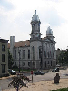 |
Clinton Co. Courthouse, Jay & Water Sts., Lock Haven °N °W |
City | Business & Industry, Government & Politics, Government & Politics 19th Century | |
| Daniel H. Hastings Daniel H. Hastings Daniel Hartman Hastings was the 21st Governor of Pennsylvania from 1895 to 1899. Although he was only 12 years old at the outbreak of the American Civil War, the young Hastings made three successive attempts to run away from home and enlist in the Union army, each time stopped by his father... |
Pa. 64 at Pa. 477 NW of Salona 41.0983°N 77.47962°W |
Roadside | Agriculture, Government & Politics, Government & Politics 19th Century, Governors | ||
| Fort Horn | Pa. 150, 4 miles NE of Lock Haven (Missing) °N °W |
Roadside | American Revolution, Forts, Military | ||
| Fort Reed | Pa. 120 (W. Main St. & W. Water St.), Lock Haven °N °W |
Roadside | Forts, French & Indian War, Military | ||
| Great Island, The | Pa. 150 (old U.S. 220), 1.3 miles NE of Lock Haven °N °W |
Roadside | Native American | ||
| Great Shamokin Path Great Shamokin Path The Great Shamokin Path was a major Native American trail in the U.S. State of Pennsylvania that ran from the native village of Shamokin along the left bank of the West Branch Susquehanna River north and then west to the Great Island... |
Eagle Valley Rd. (PA 150/old US 220) near Beech Creek Ave., 2.3 miles SW of Lock Haven °N °W |
Roadside | Native American, Paths & Trails, Transportation | ||
| Leidy Natural Gas Boom | SR 4001 just W of the Leidy Bridge, Leidy Twp. °N °W |
Roadside | Business & Industry, Oil & Gas | ||
| Pennsylvania Canal (West Branch Division) Pennsylvania Canal (West Branch Division) The West Branch Division of the Pennsylvania Canal ran from the canal basin at Northumberland, Pennsylvania, at the confluence of the West Branch Susquehanna River with the main stem of the Susquehanna River, north through Muncy, then west through Williamsport, Jersey Shore, and Lock Haven to its... |
Pa. 120 (E. Water St. near Jay St.), Lock Haven °N °W |
Roadside | Canals, Navigation, Transportation | ||
| Shamokin Path | Pa. 150, 6 miles NE of Lock Haven (Missing) °N °W |
Roadside | Native American, Paths & Trails, Transportation | ||
| Sinnemahoning Path Sinnemahoning Path The Sinnemahoning Path is an ancient trail which passes through what will be called Keating on its way to the upper Alleghenies. The Sinnemahoning Path followed the West Branch of the Susquehanna from “the Great Island” at Lock Haven to the Sinnemahoning Creek at Keating, to Portage Creek, then to... |
Pa. 120, 14 miles NW of Lock Haven °N °W |
Roadside | Native American, Paths & Trails, Transportation | ||
| Tiadaghton Elm Fair Play Men The Fair Play Men were illegal settlers who established their own system of self-rule from 1773 to 1785 in the West Branch Susquehanna River valley of Pennsylvania in what is now the United States. Because they settled in territory claimed by Native Americans, they had no recourse to the... |
River Rd. (SR 1016 / old US 220), at Bonner Ln., SE of Avis 41.18°N 77.27865°W |
Roadside | Government & Politics, Government & Politics 18th Century | ||
| Tiadaghton Elm Fair Play Men The Fair Play Men were illegal settlers who established their own system of self-rule from 1773 to 1785 in the West Branch Susquehanna River valley of Pennsylvania in what is now the United States. Because they settled in territory claimed by Native Americans, they had no recourse to the... |
2 miles S of River Rd. (SR 1016 / old US 220), just off twp. road E of Avis (Missing) °N °W |
Roadside | Government & Politics, Government & Politics 18th Century |
See also
- List of Pennsylvania state historical markers
- National Register of Historic Places listings in Clinton County, PennsylvaniaNational Register of Historic Places listings in Clinton County, PennsylvaniaThis is a list of the National Register of Historic Places listings in Clinton County, Pennsylvania.This is intended to be a complete list of the properties and districts on the National Register of Historic Places in Clinton County, Pennsylvania, United States...