

Linear scale
Encyclopedia
A linear scale, also called a bar scale, scale bar, graphic scale, or graphical scale, is a means of visually showing the scale
of a map
, nautical chart
, engineering drawing
, or architectural drawing
.
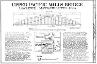
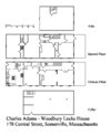
On large scale maps and charts, those covering a small area, and engineering and architectural drawings, the linear scale can be very simple, a line marked at intervals to show the distance on the earth or object which the distance on the scale represents. A person using the map can use a pair of dividers (or, less precisely, two fingers) to measure a distance by comparing it to the linear scale. The length of the line on the linear scale is equal to the distance represented on the earth multiplied by the map or chart's scale.
In most projections
, scale varies with latitude, so on small scale maps, covering large areas and a wide range of latitudes, the linear scale must show the scale for the range of latitudes covered by the map. One of these is shown below.
Since most nautical charts are constructed using the Mercator projection
whose scale varies substantially with latitude, linear scales are not used on charts with scales smaller than approximately 1/80,000. Mariners generally use the nautical mile
, which, because a nautical mile is approximately equal to a minute of latitude, can be measured against the latitude scale at the sides of the chart.
While linear scales are used on architectural and engineering drawings, particularly those that are drawn after the subject has been built, many such drawings do not have a linear scale and are marked "Do Not Scale Drawing" in recognition of the fact that paper size changes with environmental changes and only dimensions that are specifically shown on the drawing can be used reliably in precise manufacturing.
defined only "bar scale" in its 1962 Glossary,, but added a reference to "graphic scale" by its 2002 edition. Dutton used both terms in 1978. The International Hydrographic Organization
's Chart No. 1 uses only "linear scale". The British Admiralty's Mariner's Handbook uses "scale" to describe a linear scale and avoids confusion by using "natural scale" for the fraction defined at scale (map)
.
Scale (map)
The scale of a map is defined as the ratio of a distance on the map to the corresponding distance on the ground.If the region of the map is small enough for the curvature of the Earth to be neglected, then the scale may be taken as a constant ratio over the whole map....
of a map
Map
A map is a visual representation of an area—a symbolic depiction highlighting relationships between elements of that space such as objects, regions, and themes....
, nautical chart
Nautical chart
A nautical chart is a graphic representation of a maritime area and adjacent coastal regions. Depending on the scale of the chart, it may show depths of water and heights of land , natural features of the seabed, details of the coastline, navigational hazards, locations of natural and man-made aids...
, engineering drawing
Engineering drawing
An engineering drawing, a type of technical drawing, is used to fully and clearly define requirements for engineered items.Engineering drawing produces engineering drawings . More than just the drawing of pictures, it is also a language—a graphical language that communicates ideas and information...
, or architectural drawing
Architectural drawing
An architectural drawing or architect's drawing is a technical drawing of a building that falls within the definition of architecture...
.
On large scale maps and charts, those covering a small area, and engineering and architectural drawings, the linear scale can be very simple, a line marked at intervals to show the distance on the earth or object which the distance on the scale represents. A person using the map can use a pair of dividers (or, less precisely, two fingers) to measure a distance by comparing it to the linear scale. The length of the line on the linear scale is equal to the distance represented on the earth multiplied by the map or chart's scale.
In most projections
Map projection
A map projection is any method of representing the surface of a sphere or other three-dimensional body on a plane. Map projections are necessary for creating maps. All map projections distort the surface in some fashion...
, scale varies with latitude, so on small scale maps, covering large areas and a wide range of latitudes, the linear scale must show the scale for the range of latitudes covered by the map. One of these is shown below.
Since most nautical charts are constructed using the Mercator projection
Mercator projection
The Mercator projection is a cylindrical map projection presented by the Belgian geographer and cartographer Gerardus Mercator, in 1569. It became the standard map projection for nautical purposes because of its ability to represent lines of constant course, known as rhumb lines or loxodromes, as...
whose scale varies substantially with latitude, linear scales are not used on charts with scales smaller than approximately 1/80,000. Mariners generally use the nautical mile
Nautical mile
The nautical mile is a unit of length that is about one minute of arc of latitude along any meridian, but is approximately one minute of arc of longitude only at the equator...
, which, because a nautical mile is approximately equal to a minute of latitude, can be measured against the latitude scale at the sides of the chart.
While linear scales are used on architectural and engineering drawings, particularly those that are drawn after the subject has been built, many such drawings do not have a linear scale and are marked "Do Not Scale Drawing" in recognition of the fact that paper size changes with environmental changes and only dimensions that are specifically shown on the drawing can be used reliably in precise manufacturing.
Nomenclature
The terms "bar scale", "graphic scale", "graphical scale", "linear scale", and "scale" are all used. BowditchBowditch's American Practical Navigator
The American Practical Navigator , originally written by Nathaniel Bowditch, is an encyclopedia of navigation. It serves as a valuable handbook on oceanography and meteorology, and contains useful tables and a maritime glossary...
defined only "bar scale" in its 1962 Glossary,, but added a reference to "graphic scale" by its 2002 edition. Dutton used both terms in 1978. The International Hydrographic Organization
International Hydrographic Organization
The International Hydrographic Organization is the inter-governmental organisation representing the hydrographic community. It enjoys observer status at the UN and is the recognised competent authority on hydrographic surveying and nautical charting...
's Chart No. 1 uses only "linear scale". The British Admiralty's Mariner's Handbook uses "scale" to describe a linear scale and avoids confusion by using "natural scale" for the fraction defined at scale (map)
Scale (map)
The scale of a map is defined as the ratio of a distance on the map to the corresponding distance on the ground.If the region of the map is small enough for the curvature of the Earth to be neglected, then the scale may be taken as a constant ratio over the whole map....
.