

Levelling
Encyclopedia
Levelling or leveling is a branch of surveying, the object of which is
1) To find the elevation of a given point with respect to the given or assumed Datum.
2) to establish a point at a given elevation with respect to the given or assumed Datum.
Levelling or leveling is the measurement of geodetic
height
using an optical levelling instrument and a level staff
or rod having a numbered scale. Common levelling instruments include the spirit level
, the dumpy level
, the digital level, and the laser level
.
, an instrument consisting of a telescope and a tube level like that used by carpenters, rigidly connected. When the bubble in the tube level is in the middle, the telescope's optical axis (collimation axis) will point exactly in the direction of the local horizontal.
The spirit level is placed on a tripod in the middle between the two points whose height difference is to be determined; the points are marked by markers or benchmark
s in the rock or soil. A leveling staff or rod is placed on each point, with measured graduations, usually in centimetres and fractions thereof, or tenths and hundredths of a foot. The observer focuses in turn on each rod and reads the value from it. Subtracting the "back" and "forward" value provides the height difference.
The rod is then held on an unknown point and a foresight reading is taken in the same manner, allowing the elevation of the new point to be computed. The procedure is repeated until the destination point is reached. It is usual practice to perform either a complete loop back to the starting point or else close the traverse on a second point whose elevation is already known. The closure check guards against blunders in the operation, and allows residual error to be distributed in the most likely manner among the stations.
Some instruments provide three crosshairs which allow stadia
measurement of the foresight and backsight distances. These also allow use of the average of the three readings (3-wire leveling) as a check against blunders and for averaging out the error of interpolation between marks on the rod scale.
The two main types of levelling are single-levelling as already described, and double-levelling (Double-rodding). In double-levelling, a surveyor takes two foresights and two backsights and makes sure the difference between the foresights and the difference between the backsights are equal, thereby reducing the amount of error. Double-levelling costs twice as much as single-levelling.
The line of sight is horizontal at the instrument, but is not a straight line because of refraction in the air. The change of air pressure with elevation causes the line of sight to bend toward the earth. The amount of refraction depends slightly on air temperature and pressure.
The combined correction is approximately: or
or 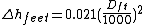
For precise work these effects need to be calculated and corrections applied. For most work it is sufficient to keep the foresight and backsight distances approximately equal so that the refraction and curvature effects cancel out.

around a loop. In the real gravity field of the Earth, this happens only approximately; on small loops typical of engineering projects, the loop closure is negligible, but on larger loops covering regions or continents it is not.
Instead of height differences, geopotential differences do close around loops:
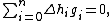
where stands for gravity at the leveling interval i. For precise leveling networks on a national scale, the latter formula should always be used.

should be used in all computations, producing geopotential values for the benchmarks of the network.
, but this fault is compensated by the practice of making foresights and backsights equal.
The Wye level is another older style of instrument, whose operation is similar to that of the dumpy level.
Precise Level designs were often used for large leveling projects where utmost accuracy was required. They differ from other levels in having a very precise spirit level tube and a micrometer adjustment to raise or lower the line of sight so that the crosshair can be made to coincide with a line on the rod scale and no interpolation is required.
The sensor can be mounted on earth-moving machinery to allow automated grading.
1) To find the elevation of a given point with respect to the given or assumed Datum.
2) to establish a point at a given elevation with respect to the given or assumed Datum.
Levelling or leveling is the measurement of geodetic
Geodetic system
Geodetic systems or geodetic data are used in geodesy, navigation, surveying by cartographers and satellite navigation systems to translate positions indicated on their products to their real position on earth....
height
Height
Height is the measurement of vertical distance, but has two meanings in common use. It can either indicate how "tall" something is, or how "high up" it is. For example "The height of the building is 50 m" or "The height of the airplane is 10,000 m"...
using an optical levelling instrument and a level staff
Level staff
A level staff, also called levelling rod, is a graduated wooden or aluminum rod, the use of which permits the determination of differences in elevation.-Rod construction and materials:...
or rod having a numbered scale. Common levelling instruments include the spirit level
Spirit level
A spirit level or bubble level is an instrument designed to indicate whether a surface ishorizontal or vertical . Different types of spirit levels may be used by carpenters, stonemasons, bricklayers, other building trades workers, surveyors, millwrights and other metalworkers, and in some...
, the dumpy level
Dumpy level
A dumpy level, builder's auto level, leveling instrument, or automatic level is an optical instrument used to establish or check points in the same horizontal plane...
, the digital level, and the laser level
Laser level
In surveying and construction, the laser level is affixed to a tripod, leveled and then spun to illuminate a horizontal plane. The laser beam projector employs a rotating head with a mirror for sweeping the laser beam about a vertical axis. If the mirror is not self-leveling, it is provided with...
.
Spirit (Optical) levelling
Spirit levelling employs a spirit levelSpirit level
A spirit level or bubble level is an instrument designed to indicate whether a surface ishorizontal or vertical . Different types of spirit levels may be used by carpenters, stonemasons, bricklayers, other building trades workers, surveyors, millwrights and other metalworkers, and in some...
, an instrument consisting of a telescope and a tube level like that used by carpenters, rigidly connected. When the bubble in the tube level is in the middle, the telescope's optical axis (collimation axis) will point exactly in the direction of the local horizontal.
The spirit level is placed on a tripod in the middle between the two points whose height difference is to be determined; the points are marked by markers or benchmark
Benchmark (surveying)
The term bench mark, or benchmark, originates from the chiseled horizontal marks that surveyors made in stone structures, into which an angle-iron could be placed to form a "bench" for a leveling rod, thus ensuring that a leveling rod could be accurately repositioned in the same place in the future...
s in the rock or soil. A leveling staff or rod is placed on each point, with measured graduations, usually in centimetres and fractions thereof, or tenths and hundredths of a foot. The observer focuses in turn on each rod and reads the value from it. Subtracting the "back" and "forward" value provides the height difference.
Leveling Procedure
A typical procedure is to set up the instrument within 100 meters (100 yards) of a known or assumed reference elevation point. A rod or staff is held on the point and the instrument is used either manually or automatically to read the rod scale as a backsight. This determines the height of the instrument above the point and allows the height of the instrument (H.I.) above the datum to be computed.The rod is then held on an unknown point and a foresight reading is taken in the same manner, allowing the elevation of the new point to be computed. The procedure is repeated until the destination point is reached. It is usual practice to perform either a complete loop back to the starting point or else close the traverse on a second point whose elevation is already known. The closure check guards against blunders in the operation, and allows residual error to be distributed in the most likely manner among the stations.
Some instruments provide three crosshairs which allow stadia
Stadia mark
Stadia marks, also called stadia lines or stadia hairs, are crosshairs on the reticle of a theodolite or other surveying instrument that allow stadiametric rangefinding.-Etymology:...
measurement of the foresight and backsight distances. These also allow use of the average of the three readings (3-wire leveling) as a check against blunders and for averaging out the error of interpolation between marks on the rod scale.
The two main types of levelling are single-levelling as already described, and double-levelling (Double-rodding). In double-levelling, a surveyor takes two foresights and two backsights and makes sure the difference between the foresights and the difference between the backsights are equal, thereby reducing the amount of error. Double-levelling costs twice as much as single-levelling.
Refraction and Curvature
The curvature of the earth means that a line of sight that is horizontal at the instrument will be higher and higher above a spheroid at greater distances. The effect may be significant for some work at distances under 100 meters.The line of sight is horizontal at the instrument, but is not a straight line because of refraction in the air. The change of air pressure with elevation causes the line of sight to bend toward the earth. The amount of refraction depends slightly on air temperature and pressure.
The combined correction is approximately:
or For precise work these effects need to be calculated and corrections applied. For most work it is sufficient to keep the foresight and backsight distances approximately equal so that the refraction and curvature effects cancel out.
Leveling loops and Gravity Variations
If the Earth's gravity field were completely regular and gravity constant, leveling loops would always close precisely:around a loop. In the real gravity field of the Earth, this happens only approximately; on small loops typical of engineering projects, the loop closure is negligible, but on larger loops covering regions or continents it is not.
Instead of height differences, geopotential differences do close around loops:
where
stands for gravity at the leveling interval i. For precise leveling networks on a national scale, the latter formula should always be used.should be used in all computations, producing geopotential values
for the benchmarks of the network.Older Instruments
The dumpy level is an older style of optical instrument. It is commonly believed that dumpy levelling is less accurate than other types of levelling, but such is not the case. Dumpy levelling requires shorter and therefore more numerous sightsSight (device)
A sight is a device used to assist aligning or aim weapons, surveying instruments, or other items by eye. Sights can be a simple set or system of markers that have to be aligned together as well as aligned with the target...
, but this fault is compensated by the practice of making foresights and backsights equal.
The Wye level is another older style of instrument, whose operation is similar to that of the dumpy level.
Precise Level designs were often used for large leveling projects where utmost accuracy was required. They differ from other levels in having a very precise spirit level tube and a micrometer adjustment to raise or lower the line of sight so that the crosshair can be made to coincide with a line on the rod scale and no interpolation is required.
Automatic level
Automatic levels make use of a compensator, which ensures that the line of sight is always horizontal regardless of whether or not the housing of the telescope is. This makes it easier and quicker to set up than a tilting or dumpy level. It also reduces the effect of minor settling of the tripod to the actual amount of motion instead of leveraging the tilt over the sight distance. These instruments became standard in the later part of the twentieth century.three level screws are given to adjust the instrument level.Digital Level
Digital levels electronically read a bar-coded scale on the staff. These instruments usually include data recording capability. The automation removes the requirement for the operator to read a scale and and write down the value, and so reduces blunders. It may also compute and apply refraction and curvature corrections.Laser level
Laser levels project a beam which is visible and/or detectable by a sensor on the leveling rod. This style is widely used in construction work but not for more precise control work. An advantage is that one person can perform the levelling independently, whereas other types require one person at the instrument and one holding the rod.The sensor can be mounted on earth-moving machinery to allow automated grading.