

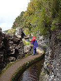
Levada
Encyclopedia
A levada is an irrigation
channel or aqueduct
specific to the island of Madeira
in the Atlantic Ocean
(about 500 miles (804.7 km) southwest of Portugal
).
A popular levada to hike is the Levada do Caldeirão Verde which continues as the Levada Caldeirão do Inferno. Together it is about 23 miles (37 km) long. Along both parts there are long sections which should not be attempted by hikers prone to vertigo
; and several tunnels for which flashlights and helmets are essential. The Levada do Caniçal is a much easier walk. This levada runs 7.1 miles (11.4 km) from Maroços to the Caniçal Tunnel. It is known as the mimosa levada because acacias (commonly misnamed mimosa
s) are found all along the route.
Irrigation
Irrigation may be defined as the science of artificial application of water to the land or soil. It is used to assist in the growing of agricultural crops, maintenance of landscapes, and revegetation of disturbed soils in dry areas and during periods of inadequate rainfall...
channel or aqueduct
Aqueduct
An aqueduct is a water supply or navigable channel constructed to convey water. In modern engineering, the term is used for any system of pipes, ditches, canals, tunnels, and other structures used for this purpose....
specific to the island of Madeira
Madeira
Madeira is a Portuguese archipelago that lies between and , just under 400 km north of Tenerife, Canary Islands, in the north Atlantic Ocean and an outermost region of the European Union...
in the Atlantic Ocean
Atlantic Ocean
The Atlantic Ocean is the second-largest of the world's oceanic divisions. With a total area of about , it covers approximately 20% of the Earth's surface and about 26% of its water surface area...
(about 500 miles (804.7 km) southwest of Portugal
Portugal
Portugal , officially the Portuguese Republic is a country situated in southwestern Europe on the Iberian Peninsula. Portugal is the westernmost country of Europe, and is bordered by the Atlantic Ocean to the West and South and by Spain to the North and East. The Atlantic archipelagos of the...
).
History
The levadas originated out of the necessity of bringing large amounts of water from the west and northwest of the island to the drier southeast, which is more conducive to habitation and agriculture (such as sugar cane production). In the sixteenth century the Portuguese started building levadas to carry water to the agricultural regions. The most recent were made in the 1940s. Madeira is very mountainous, and building the levadas was often difficult. Many are cut into the sides of mountains, and it was also necessary to dig 25 miles (40.2 km) of tunnels.Levadas today
Today the levadas not only supply water to the southern parts of the island but provide hydro-electric power. There are over 1350 miles (2,172.6 km) of levadas and they provide a remarkable network of walking paths. Some provide easy and relaxing walks through beautiful countryside, but others are narrow, crumbling ledges where a slip could result in serious injury or death.A popular levada to hike is the Levada do Caldeirão Verde which continues as the Levada Caldeirão do Inferno. Together it is about 23 miles (37 km) long. Along both parts there are long sections which should not be attempted by hikers prone to vertigo
Vertigo (medical)
Vertigo is a type of dizziness, where there is a feeling of motion when one is stationary. The symptoms are due to a dysfunction of the vestibular system in the inner ear...
; and several tunnels for which flashlights and helmets are essential. The Levada do Caniçal is a much easier walk. This levada runs 7.1 miles (11.4 km) from Maroços to the Caniçal Tunnel. It is known as the mimosa levada because acacias (commonly misnamed mimosa
Mimosa
Mimosa is a genus of about 400 species of herbs and shrubs, in the subfamily Mimosoideae of the legume family Fabaceae. The generic name is derived from the Greek word μιμος , meaning "mimic."...
s) are found all along the route.
See also
- The Canary island of La PalmaLa PalmaLa Palma is the most north-westerly of the Canary Islands. La Palma has an area of 706 km2 making it the fifth largest of the seven main Canary Islands...
also has a network of visitable water tunnels.