
Lemon technique
Encyclopedia
The Lemon technique is a method used by meteorologists using weather radar to determine the relative strength of thunderstorm
cells in a vertically sheared
environment. It is named for Leslie R. Lemon, the co-creator of the current conceptual model of a supercell
. The Lemon technique is largely a continuation of work by Keith A. Browning, who first identified and named the supercell.
The method focuses on updrafts and uses weather radar
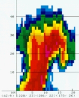
to measure quantities such as height (echo tops), reflectivity (such as morphology and gradient), and location to show features and trends described by Lemon. These features include:

Thunderstorm
A thunderstorm, also known as an electrical storm, a lightning storm, thundershower or simply a storm is a form of weather characterized by the presence of lightning and its acoustic effect on the Earth's atmosphere known as thunder. The meteorologically assigned cloud type associated with the...
cells in a vertically sheared
Wind shear
Wind shear, sometimes referred to as windshear or wind gradient, is a difference in wind speed and direction over a relatively short distance in the atmosphere...
environment. It is named for Leslie R. Lemon, the co-creator of the current conceptual model of a supercell
Supercell
A supercell is a thunderstorm that is characterized by the presence of a mesocyclone: a deep, continuously-rotating updraft. For this reason, these storms are sometimes referred to as rotating thunderstorms...
. The Lemon technique is largely a continuation of work by Keith A. Browning, who first identified and named the supercell.
The method focuses on updrafts and uses weather radar
Weather radar
Weather radar, also called weather surveillance radar and Doppler weather radar, is a type of radar used to locate precipitation, calculate its motion, estimate its type . Modern weather radars are mostly pulse-Doppler radars, capable of detecting the motion of rain droplets in addition to the...
to measure quantities such as height (echo tops), reflectivity (such as morphology and gradient), and location to show features and trends described by Lemon. These features include:
- Updraft tilt - The tilted updraftTilted updraftA tilted updraft is a thunderstorm which is not vertically erect. This happens as a result of unidirectional wind shear, or a change in wind speed with height. In such an environment, the top of the updraft is pushed further downstream than the lower parts as a result of stronger winds pushing...
(vertical orientation) of the main updraft is an indication of the strength of the updraft, with nearly vertical tilts indicating stronger updrafts.
- Echo overhang - In intense thunderstorms, an area of very strong reflectivity atop the weak echo region and on the low-level inflow inside side of the storm.
- Weak echo region (WER) - An area of markedly lower reflectivity, resulting from an increase in updraft strength.
- Bounded weak echo region (BWER) - Another area of markedly lower reflectivity, now bounded by an area of high reflectivity. This is observed as a "hole" in reflectivity, and is caused by an updraft powerful enough to prevent ice and liquid from reaching the ground. This powerful updraft is often an indication of, or is facilitated by, a mesocycloneMesocycloneA mesocyclone is a vortex of air, approximately 2 to 10 miles in diameter , within a convective storm....
. A mesocyclone is not strictly necessary for BWER development. Storm rotation can be reliably detected by the Doppler velocitiesDoppler effectThe Doppler effect , named after Austrian physicist Christian Doppler who proposed it in 1842 in Prague, is the change in frequency of a wave for an observer moving relative to the source of the wave. It is commonly heard when a vehicle sounding a siren or horn approaches, passes, and recedes from...
of a weather radarWeather radarWeather radar, also called weather surveillance radar and Doppler weather radar, is a type of radar used to locate precipitation, calculate its motion, estimate its type . Modern weather radars are mostly pulse-Doppler radars, capable of detecting the motion of rain droplets in addition to the...
.