
Lawrence Hargrave Drive
Encyclopedia
Wollongong, New South Wales
Wollongong is a seaside city located in the Illawarra region of New South Wales, Australia. It lies on the narrow coastal strip between the Illawarra Escarpment and the Pacific Ocean, 82 kilometres south of Sydney...
, New South Wales
New South Wales
New South Wales is a state of :Australia, located in the east of the country. It is bordered by Queensland, Victoria and South Australia to the north, south and west respectively. To the east, the state is bordered by the Tasman Sea, which forms part of the Pacific Ocean. New South Wales...
, Australia
Australia
Australia , officially the Commonwealth of Australia, is a country in the Southern Hemisphere comprising the mainland of the Australian continent, the island of Tasmania, and numerous smaller islands in the Indian and Pacific Oceans. It is the world's sixth-largest country by total area...
to both Wollongong and Sydney
Sydney
Sydney is the most populous city in Australia and the state capital of New South Wales. Sydney is located on Australia's south-east coast of the Tasman Sea. As of June 2010, the greater metropolitan area had an approximate population of 4.6 million people...
.
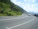
The road begins at the Old Princes Highway
Princes Highway
The Princes Highway extends from Sydney to Port Augusta via the coast through the states of New South Wales, Victoria and South Australia, a distance of 1941 km or 1898 km via the former alignments of the highway ....
, Helensburgh
Helensburgh, New South Wales
Helensburgh is a small town in New South Wales, Australia. Helensburgh is located 45 kilometres south of the Sydney central business district and north of Wollongong. Helensburgh is in the local government area of Wollongong City Council and marks the northern end of the Illawarra region...
(Southern Freeway
Southern Freeway
Southern Freeway is a freeway linking Sydney to Wollongong. It currently is designated as part of National Route 1, however was formerly signposted as F6 under a former route numbering system, and is commonly known by this latter name...
exit) and passes through Stanwell Tops
Stanwell Tops, New South Wales
Stanwell Tops is a locality between the cities of Sydney and Wollongong on the New South Wales, Australia coastline. It lies northwest of Stanwell Park and southwest of Otford.-References:...
to descend the steep Illawarra Escarpment
Illawarra escarpment
The Illawarra Escarpment is the fold created cliffs and plateau eroded outcrop mountain range west of the Illawarra coastal plain south of Sydney, Australia, enclosing the region known as the Illawarra which stretches from Stanwell Park in the north to Kiama, Gerringong and the Shoalhaven river in...
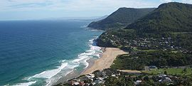
at Bald Hill, the site of a spectacular lookout and hang gliding
Hang gliding
Hang gliding is an air sport in which a pilot flies a light and unmotorized foot-launchable aircraft called a hang glider ....
area. The road then passes south through Stanwell Park
Stanwell Park, New South Wales
Stanwell Park is a picturesque coastal village and northern suburb of Wollongong, New South Wales, Australia. It is the northernmost point of the Illawarra coastal strip and lies south of Sydney's Royal National Park. It is situated in a small valley between Bald Hill to the north, Stanwell Tops...
and Coalcliff
Coalcliff, New South Wales
Coalcliff is a town on the coast of New South Wales, Australia, between Sydney and Wollongong. Together with Stanwell Park it belongs to the Little Bulli indentation of the northern Illawarra coast strip.- History :...
to cross the renowned Sea Cliff Bridge
Sea Cliff Bridge
The Sea Cliff Bridge is a balanced cantilever bridge located in the northern Illawarra region of New South Wales, Australia. The $52 million bridge links the coastal villages of Coalcliff and Clifton...
. The Sea Cliff Bridge construction was completed in December 2005, replacing the former cliff-hugging route which was prone to rockfalls. The road then winds its way through the coastal villages of Clifton
Clifton, New South Wales
Clifton is a village on the coast of New South Wales, Australia, between Sydney and Wollongong. Along with nearby Coalcliff, the village began life as a coal-mining centre. It is situated on a narrow area between the sea and the Illawarra escarpment...
, Scarborough
Scarborough, New South Wales
Scarborough is a small northern seaside suburb of Wollongong on the south coast of New South Wales, Australia. It sits in the northern Illawarra region on a narrow stretch between the Illawarra escarpment and sea cliffs....
, Wombarra
Wombarra, New South Wales
Wombarra , is a small beachside community now a far northern suburb of the city of Wollongong, New South Wales, Australia. Wombarra is understood to be an Aboriginal term meaning "Black Duck".[2]....
, Coledale
Coledale, New South Wales
Coledale is a small sea-side village approximately 18 kilometres north of Wollongong along the Princes Highway in New South Wales, Australia. It is part of the City of Wollongong and lies between Wombarra and Austinmer....
, Austinmer
Austinmer, New South Wales
Austinmer is a northern suburb of Wollongong on the south coast of New South Wales, Australia. It sits in the northern Illawarra region, south of Stanwell Park and immediately north of Thirroul....
and finally Thirroul
Thirroul, New South Wales
Thirroul is a northern seaside suburb of the city of Wollongong, Australia, with the name supposedly Aboriginal for "Valley of Cabbage Tree Palms". Situated between Austinmer and Bulli, it is approximately 13 kilometres north of Wollongong, and 69 km south of Sydney...
where it meets the Princes Highway
Princes Highway
The Princes Highway extends from Sydney to Port Augusta via the coast through the states of New South Wales, Victoria and South Australia, a distance of 1941 km or 1898 km via the former alignments of the highway ....
at the bottom of Bulli Pass
Bulli Pass
Bulli Pass is a mountain pass northwest of Bulli, New South Wales, Australia. It is situated on the Illawarra Escarpment west of the Illawarra coastal plain. It was built during the 19th century for use by loggers and locals transporting goods to and from Sydney...
.
The road is named after Lawrence Hargrave
Lawrence Hargrave
Lawrence Hargrave was an engineer, explorer, astronomer, inventor and aeronautical pioneer.- Early life :Hargrave was born in Greenwich, England, the second son of John Fletcher Hargrave and was educated at Queen Elizabeth's Grammar School, Kirkby Lonsdale, Westmorland...
, an Australian aviation pioneer and explorer who had a house at Stanwell Park and flew his devices from Bald Hill.
See also
- Bald Hill
- Bulli PassBulli PassBulli Pass is a mountain pass northwest of Bulli, New South Wales, Australia. It is situated on the Illawarra Escarpment west of the Illawarra coastal plain. It was built during the 19th century for use by loggers and locals transporting goods to and from Sydney...
- Illawarra escarpmentIllawarra escarpmentThe Illawarra Escarpment is the fold created cliffs and plateau eroded outcrop mountain range west of the Illawarra coastal plain south of Sydney, Australia, enclosing the region known as the Illawarra which stretches from Stanwell Park in the north to Kiama, Gerringong and the Shoalhaven river in...
- Sea Cliff BridgeSea Cliff BridgeThe Sea Cliff Bridge is a balanced cantilever bridge located in the northern Illawarra region of New South Wales, Australia. The $52 million bridge links the coastal villages of Coalcliff and Clifton...