
Laupahoehoe, Hawai'i
Encyclopedia
Laupāhoehoe is a census-designated place
(CDP) in Hawaii County
, Hawaii
, United States
located in the District of North Hilo. The population was 581 at the 2010 census.
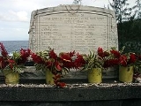
of Hawaii was struck by the so-called "April Fools Day tsunami
", originating from the Aleutian Islands earthquake. Approximately 160 people on the island were killed. While the greatest number of deaths occurred in Hilo, the school building at Laupāhoehoe was inundated, and twenty students and four teachers were drowned. A monument to the dead now stands on Laupāhoehoe Point. The community's name means "leaf-lava" and is named for the leaf-shaped lava that lines many of its beaches.
According to the United States Census Bureau
, the CDP has a total area of 2.3 square miles (6 km²), of which, 2.1 square miles (5.4 km²) of it is land and 0.2 square mile (0.517997622 km²) of it (8.41%) is water.
of 2010, there were 581 people in 214 households residing in the CDP. The population density
was 276.7 people per square mile (107.6/km²). There were 243 housing units at an average density of 115.7 per square mile (45.0/km²). The racial makeup of the CDP was 36.49% White, 0.34% African American, 0.17% American Indian & Alaska Native, 24.44% Asian, 4.82% Native Hawaiian & Pacific Islander, 0.86% from other races
, and 32.87% from two or more races. Hispanic or Latino of any race were 18.59% of the population.
There were 214 households out of which 28.0% had children under the age of 18 living with them. The average household size was 2.71.
In the Laupahoehoe CDP the population was spread out with 23.9% under the age of 18, 5.0% from 18 to 24, 12.9% from 25 to 34, 15.1% from 35 to 49, 26.0% from 50 to 64, and 17.0% who were 65 years of age or older. For every 100 females there were 105.3 males. For every 100 males there were 95.0 females.
The median income for a household in the CDP at the 2000 census was $29,250, and the median income for a family in 2000 was $30,000. Males had a median income in 2000 of $21,667 versus $21,607 for females. The per capita income
for the CDP in 2000 was $11,896. About 28.4% of families and 25.2% of the population were below the poverty line in 2000, including 41.1% of those under age 18 and 14.0% of those age 65 or over.
Census-designated place
A census-designated place is a concentration of population identified by the United States Census Bureau for statistical purposes. CDPs are delineated for each decennial census as the statistical counterparts of incorporated places such as cities, towns and villages...
(CDP) in Hawaii County
Hawaii County, Hawaii
Hawaii County is a county located in the U.S. state of Hawaii in the Hawaiian Islands. It is coterminous with the Island of Hawaii, often called the "Big Island" to distinguish it from the state as a whole. As of the 2010 Census the population was 185,079. The county seat is Hilo. There are no...
, Hawaii
Hawaii
Hawaii is the newest of the 50 U.S. states , and is the only U.S. state made up entirely of islands. It is the northernmost island group in Polynesia, occupying most of an archipelago in the central Pacific Ocean, southwest of the continental United States, southeast of Japan, and northeast of...
, United States
United States
The United States of America is a federal constitutional republic comprising fifty states and a federal district...
located in the District of North Hilo. The population was 581 at the 2010 census.
History
On April 1, 1946 the Big IslandHawaii (island)
The Island of Hawaii, also called the Big Island or Hawaii Island , is a volcanic island in the North Pacific Ocean...
of Hawaii was struck by the so-called "April Fools Day tsunami
Tsunami
A tsunami is a series of water waves caused by the displacement of a large volume of a body of water, typically an ocean or a large lake...
", originating from the Aleutian Islands earthquake. Approximately 160 people on the island were killed. While the greatest number of deaths occurred in Hilo, the school building at Laupāhoehoe was inundated, and twenty students and four teachers were drowned. A monument to the dead now stands on Laupāhoehoe Point. The community's name means "leaf-lava" and is named for the leaf-shaped lava that lines many of its beaches.
Geography
Laupāhoehoe is located at 19°59′5"N 155°14′10"W (19.983296, -155.235889).According to the United States Census Bureau
United States Census Bureau
The United States Census Bureau is the government agency that is responsible for the United States Census. It also gathers other national demographic and economic data...
, the CDP has a total area of 2.3 square miles (6 km²), of which, 2.1 square miles (5.4 km²) of it is land and 0.2 square mile (0.517997622 km²) of it (8.41%) is water.
Demographics
As of the censusCensus
A census is the procedure of systematically acquiring and recording information about the members of a given population. It is a regularly occurring and official count of a particular population. The term is used mostly in connection with national population and housing censuses; other common...
of 2010, there were 581 people in 214 households residing in the CDP. The population density
Population density
Population density is a measurement of population per unit area or unit volume. It is frequently applied to living organisms, and particularly to humans...
was 276.7 people per square mile (107.6/km²). There were 243 housing units at an average density of 115.7 per square mile (45.0/km²). The racial makeup of the CDP was 36.49% White, 0.34% African American, 0.17% American Indian & Alaska Native, 24.44% Asian, 4.82% Native Hawaiian & Pacific Islander, 0.86% from other races
Race (United States Census)
Race and ethnicity in the United States Census, as defined by the Federal Office of Management and Budget and the United States Census Bureau, are self-identification data items in which residents choose the race or races with which they most closely identify, and indicate whether or not they are...
, and 32.87% from two or more races. Hispanic or Latino of any race were 18.59% of the population.
There were 214 households out of which 28.0% had children under the age of 18 living with them. The average household size was 2.71.
In the Laupahoehoe CDP the population was spread out with 23.9% under the age of 18, 5.0% from 18 to 24, 12.9% from 25 to 34, 15.1% from 35 to 49, 26.0% from 50 to 64, and 17.0% who were 65 years of age or older. For every 100 females there were 105.3 males. For every 100 males there were 95.0 females.
The median income for a household in the CDP at the 2000 census was $29,250, and the median income for a family in 2000 was $30,000. Males had a median income in 2000 of $21,667 versus $21,607 for females. The per capita income
Per capita income
Per capita income or income per person is a measure of mean income within an economic aggregate, such as a country or city. It is calculated by taking a measure of all sources of income in the aggregate and dividing it by the total population...
for the CDP in 2000 was $11,896. About 28.4% of families and 25.2% of the population were below the poverty line in 2000, including 41.1% of those under age 18 and 14.0% of those age 65 or over.
External links
- Laupāhoehoe, Hawai'i is at coordinates 19°59′5"N 155°14′10"W.
- Laupahoehoe Train Museum