

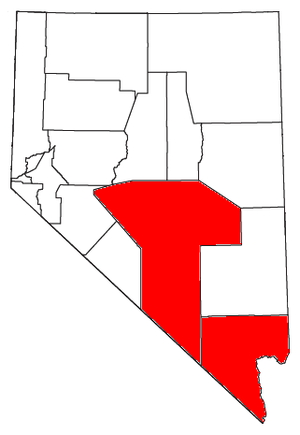
Las Vegas-Paradise-Pahrump combined statistical area
Encyclopedia
Nevada
Nevada is a state in the western, mountain west, and southwestern regions of the United States. With an area of and a population of about 2.7 million, it is the 7th-largest and 35th-most populous state. Over two-thirds of Nevada's people live in the Las Vegas metropolitan area, which contains its...
. The statistical area consists of the Las Vegas-Paradise, NV MSA and the Pahrump Micropolitan Statistical Area
Nye County, Nevada
-National protected areas:* Ash Meadows National Wildlife Refuge* Death Valley National Park * Humboldt-Toiyabe National Forest * Spring Mountains National Recreation Area -Demographics:...
. Also contained are portions of northwest Arizona. At the 2000 census
United States Census, 2000
The Twenty-second United States Census, known as Census 2000 and conducted by the Census Bureau, determined the resident population of the United States on April 1, 2000, to be 281,421,906, an increase of 13.2% over the 248,709,873 persons enumerated during the 1990 Census...
, the CSA had a population of 1,408,250 (though a July 1, 2009, estimate placed the population at 1,947,068).
Incorporated places
- Boulder CityBoulder City, NevadaBoulder City is a city in Clark County, Nevada, United States. It is approximately from the City of Las Vegas. As of the 2010 census the population of Boulder City was 15,023.Boulder City is one of only two cities in Nevada that prohibit gambling....
- HendersonHenderson, Nevada-Demographics:According to the 2000 census, there were 175,381 people, 66,331 households, and 47,095 families residing in the city. The population density was 2,200.8 people per square mile . There were 71,149 housing units at an average density of 892.8 per square mile...
- Las VegasLas Vegas, NevadaLas Vegas is the most populous city in the U.S. state of Nevada and is also the county seat of Clark County, Nevada. Las Vegas is an internationally renowned major resort city for gambling, shopping, and fine dining. The city bills itself as The Entertainment Capital of the World, and is famous...
(Principal city) - North Las VegasNorth Las Vegas, NevadaNorth Las Vegas is a city in Clark County, Nevada, United States, located in the Las Vegas metropolitan area. The city was incorporated on May 16, 1946.-Geography:...
- MesquiteMesquite, NevadaMesquite is a city in Clark County, Nevada, United States, adjacent to the Arizona state line and northeast of Las Vegas. As of the 2010 United States Census, it had a population of 15,277. The city is located in the Virgin River Valley...
- Bullhead City, ArizonaBullhead City, ArizonaBullhead City is a city located on the Colorado River in Mohave County, Arizona, USA, roughly south of Las Vegas, Nevada, and directly across the Colorado River from Laughlin, Nevada, whose casinos and ancillary services supply much of the employment for Bullhead City...
Census-designated places
Note: All census-designated places are unincorporatedUnincorporated area
In law, an unincorporated area is a region of land that is not a part of any municipality.To "incorporate" in this context means to form a municipal corporation, a city, town, or village with its own government. An unincorporated community is usually not subject to or taxed by a municipal government...
.
|
Mountain's Edge, Nevada Mountain's Edge is a master planned community in the unincorporated town of Enterprise in Clark County, Nevada.-History:Focus Property Group started the construction of Mountain's Edge in February, 2004. The development plans included 14,500 homes and more than 22 neighborhoods with stores, office... Pahrump, Nevada -Demographics:As of the census of 2000, there were 24,631 people, 10,153 households, and 7,127 families residing in the CDP. The population density was 82.7 people per square mile . There were 11,651 housing units at an average density of 39.1 per square mile... (Principal city) Paradise, Nevada Paradise is an unincorporated town in the Las Vegas metropolitan area in Clark County, Nevada, United States. The population was 223,167 at the 2010 census... (Principal city) Sandy Valley, Nevada Sandy Valley is a census-designated place in the Mesquite Valley in west-central Clark County, Nevada, United States. Sandy Valley has variant name of Sandy, Nevada. The population was 1,804 at the 2000 census. Sandy Valley is bordered on the East by the southern extension of the Spring Mountains... Searchlight, Nevada Searchlight is an unincorporated town in Clark County, Nevada, at the topographic saddle between two mountain ranges.-History:According to Nevada Senator Harry Reid, who has written extensively about his hometown, the most likely story as to how the town received its name was when George Frederick... Spring Valley, Nevada Spring Valley is an unincorporated town in Clark County, Nevada, United States located two miles west of the Las Vegas Strip. The population was 117,390 at the 2000 census.-Background:... Summerlin South, Nevada Summerlin South, also seen on maps as South Summerlin, is an affluent census-designated place in Clark County, Nevada, United States, on the western edge of Las Vegas and adjacent to the Red Rock Canyon National Conservation Area. It is so named because it is a southward extension of the... Sunrise Manor, Nevada Sunrise Manor is an unincorporated town in Clark County, Nevada, United States, located on the western base of Frenchman Mountain, east of Las Vegas. The population was 189,372 at the 2010 census... Tonopah, Nevada Tonopah is a census-designated place located in and the county seat of Nye County, Nevada. It is located at the junction of U.S. Routes 6 and 95 approximately mid-way between Las Vegas and Reno.... Whitney, Nevada Whitney is an unincorporated town in Clark County, Nevada, United States. The population was 18,273 at the 2000 census.-Background:... Winchester, Nevada Winchester is a census-designated place in Clark County, Nevada, United States that contains part of the Las Vegas Strip. It is one of a number of CDPs in the unincorporated urbanized area directly south of Las Vegas. The population was 26,958 at the 2000 census. It is governed by the Clark County... |
Unincorporated places
|
Logandale, Nevada Logandale is an unincorporated town located in Clark County, Nevada. The community is the home of the annual Clark County Fair and Rodeo. It began as a railroad station in 1912. It was originally named Logan but renamed to avoid confusion with Logan, Utah.... Manhattan, Nevada Manhattan is a small town in Nye County, Nevada located on State Route 377 about 50 miles north of Tonopah, the county seat, off State Route 376.... Mercury, Nevada Mercury, Nevada is a town in Nye County, Nevada, United States, 5 miles north of U.S. Route 95 at a point 65 miles further northwest of Las Vegas. It is situated within the Nevada Test Site and was constructed by the Atomic Energy Commission to house and service the staff of the test site. The... Mountain Springs, Nevada Mountain Springs is a small community in Clark County in southern Nevada. It is located at the pass over the Spring Mountains through which Highway 160 connects Las Vegas and Pahrump. Public buildings include a fire house and a saloon.-External links:*... Nelson, Nevada Nelson is an unincorporated community in Clark County, Nevada, United States, in the Las Vegas metropolitan area. The community is in the Pacific Standard Time zone. The location of Nelson is in El Dorado Canyon, Eldorado Mountains... Overton, Nevada Overton is an Unincorporated Town located in Clark County, Nevada. The town is on the north end of Lake Mead. The town is home to Perkins Field airport and Echo Bay Airport.... Primm, Nevada Primm is a tiny community in Clark County, Nevada, United States, primarily notable for its position straddling Interstate 15 where it crosses the border between California and Nevada... Round Mountain, Nevada Round Mountain is a small town in Nye County, Nevada. The population of Round Mountain, Nevada as of 2005 is 744 .Round Mountain is best known for the Round Mountain Gold Mine, a large open pit heap-leach gold mine owned by Kinross Gold Corporation and Barrick Gold Corporation... Scotty's Junction, Nevada Scotty's Junction is a place in Nye County, Nevada where State Route 267 meets with U.S. Route 95. It is named after Walter E. Scott .... Sloan, Nevada Sloan is an unincorporated community in Clark County, Nevada.It contains well-preserved petroglyphs and several hiking trails that allow visitors to photograph the petroglyphs... Sunnyside, Nevada Sunnyside is a small community in the White River Valley of Eastern Nevada, near the Southern terminus of the Egan Range. The site is located on Nevada State Route 318 approximately 31 miles by road South of Lund in White Pine County, the closest town, and 63 miles by road North by east of Hiko in... |
Demographics
At the 2000 censusCensus
A census is the procedure of systematically acquiring and recording information about the members of a given population. It is a regularly occurring and official count of a particular population. The term is used mostly in connection with national population and housing censuses; other common...
, there were 1,408,250 people, 525,562 households and 348,686 families residing within the CSA. The racial makeup of the CSA was 72.00% White, 8.90% African American, 0.82% Native American, 5.17% Asian, 0.46% Pacific Islander, 8.48% from other races
Race (United States Census)
Race and ethnicity in the United States Census, as defined by the Federal Office of Management and Budget and the United States Census Bureau, are self-identification data items in which residents choose the race or races with which they most closely identify, and indicate whether or not they are...
, and 4.17% from two or more races. Hispanic or Latino of any race were 21.65% of the population.
The median household income
Median household income
The median household income is commonly used to generate data about geographic areas and divides households into two equal segments with the first half of households earning less than the median household income and the other half earning more...
was $40,320 and the family median income was $46,064. Males had a median income of $36,260 versus $24,736 for females. The per capita income
Per capita income
Per capita income or income per person is a measure of mean income within an economic aggregate, such as a country or city. It is calculated by taking a measure of all sources of income in the aggregate and dividing it by the total population...
for the CSA was $19,874.