

Langstone Harbour
Encyclopedia
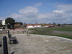
Langstone Harbour is an inlet of the English Channel
English Channel
The English Channel , often referred to simply as the Channel, is an arm of the Atlantic Ocean that separates southern England from northern France, and joins the North Sea to the Atlantic. It is about long and varies in width from at its widest to in the Strait of Dover...
in Hampshire, sandwiched between Portsea Island
Portsea Island
Portsea Island is a small, flat and low lying island just off the south coast of England. The island is totally within, and contains a large proportion of, the city of Portsmouth. It has the third-largest population of any island in the British Isles, after the mainlands of Great Britain and...
to the south and west, Hayling Island
Hayling Island
-Leisure activities:Although largely residential, Hayling is also a holiday, windsurfing and sailing centre, the site where windsurfing was invented....
to the south and east, and Langstone
Langstone
Langstone is a village near Havant, Hampshire in the south east of England, between Portsmouth and Chichester. It has good railway connections to London, Southampton, Portsmouth and Brighton, from the nearby Havant railway station. There are many large gated detached houses on the main road,...
to the north. Geographically it is a ria
Ria
A ria is a coastal inlet formed by the partial submergence of an unglaciated river valley. It is a drowned river valley that remains open to the sea. Typically, rias have a dendritic, treelike outline although they can be straight and without significant branches. This pattern is inherited from the...
.
Together with Chichester Harbour
Chichester Harbour
Chichester Harbour is a large natural harbour to the south west of the city of Chichester on the Solent. It straddles the boundary of West Sussex and Hampshire. Geographically it is a ria. It is one of four natural harbours in that area of the coastline, the others being Portsmouth Harbour,...
, which is at the other (eastern) side of Hayling Island it is designated as a Special Protection Area
Special Protection Area
A Special Protection Area or SPA is a designation under the European Union Directive on the Conservation of Wild Birds.Under the Directive, Member States of the European Union have a duty to safeguard the habitats of migratory birds and certain particularly threatened birds.Together with Special...
for wildlife. West of Portsmouth is Portsmouth Harbour
Portsmouth Harbour
Portsmouth Harbour is a large natural harbour in Hampshire, England. Geographically it is a ria: formerly it was the valley of a stream flowing from Portsdown into the Solent River. The city of Portsmouth lies to the east on Portsea Island, and Gosport to the west on the mainland...
and the three linked harbours are important recreational and conservation areas as well as supporting commercial fishing and shipping. It is administered by the Langstone Harbour Board.
The eastern boundary with Chichester Harbour is defined by an historic causeway known as the wade way, which was originally the only crossing between Hayling Island
Hayling Island
-Leisure activities:Although largely residential, Hayling is also a holiday, windsurfing and sailing centre, the site where windsurfing was invented....
and the mainland. It is now impassible, having been cut in two by a deep channel for the Portsmouth and Arundel Canal
Portsmouth and Arundel Canal
The Portsmouth and Arundel Canal was a canal in the south of England that ran between Portsmouth and Arundel, it was built in 1823 but was never a financial success and was abandoned in 1855, the company was wound up in 1888...
in the 1820s (for further information see Langstone
Langstone
Langstone is a village near Havant, Hampshire in the south east of England, between Portsmouth and Chichester. It has good railway connections to London, Southampton, Portsmouth and Brighton, from the nearby Havant railway station. There are many large gated detached houses on the main road,...
).
Islands
Langstone Harbour contains a number of islands; Baker's IslandBaker's Island
Baker's Island is an island in Langstone Harbour. It is long and up to wide but only rises to a little over above Ordnance Datum. Mesolithic and neolithic flintwork has been found on the island along with bronze age and Romano-British pottery...
, North Binness Island
North Binness Island
North Binness Island is an island in Langstone Harbour It is long and up to wide but only rises to above Ordnance Datum The island was originally part of Binner's Island. The island has been uninhabited in recent times but there is evidence of historical occupation...
, South Binness Island
South Binness Island
South Binness Island is an island in Langstone Harbour. It is long and up to wide but only rises to above Ordnance Datum. Archaeological finds include bronze age pottery and an unfinished Plano-convex knife....
and Long Island
Long Island (Hampshire)
Long Island is an island in Langstone Harbour in Hampshire, England. It is long and up to wide. Three bronze age pots have been found on the island as has Mesolithic and late neolithic flint-work...
. These are subject to erosion and during the 1990s a seven-year archaeology project took place before their history was lost to the seas.
There are also two smaller islands. Round nap island which is connected to South Binness Island by a tidal causeway and Oyster Island.
History
Langstone Harbour was originally a river valley of one of the tributaries flowing into the then River Solent. With the end of the last ice age sea levels rose until sometime between 4000 and 3500BC the harbour took on the form it would have until the 18th century.For much of its history the harbour has been an area of salt production. The Domesday Book
Domesday Book
Domesday Book , now held at The National Archives, Kew, Richmond upon Thames in South West London, is the record of the great survey of much of England and parts of Wales completed in 1086...
records three saltern
Saltern
Saltern is a word with a number of differing meanings. In English archaeology, a saltern is an area used for salt making, especially in the East Anglian fenlands....
s around the harbour and by the early 17th century a saltern at Copner was well established. Here a large shallow area of the harbour meant that even without further improvement salt could be extracted from the area after each tide. The Copner saltern ceased production in 1800 but salt production continued elsewhere in the harbour until 1933.
In 1771 Farlington Marshes
Farlington Marshes
Farlington Marshes is an area of reclaimed land in Langstone harbour. It was reclaimed from the harbour in 1771 and includes a larger part of what was formerly Binner's Island . Farlington Marshes is about 120 hectares in size and features both freshwater marsh and brackish marsh...
were reclaimed from the north of the harbour.
Oyster farming
Oyster farming
Oyster farming is an aquaculture practice in which oysters are raised for human consumption. Oyster farming most likely developed in tandem with pearl farming, a similar practice in which oysters are farmed for the purpose of developing pearls...
began in the harbour around 1820 with Winkle and Clam
Clam
The word "clam" can be applied to freshwater mussels, and other freshwater bivalves, as well as marine bivalves.In the United States, "clam" can be used in several different ways: one, as a general term covering all bivalve molluscs...
cultivation probably starting around much the same time. Production ceased in the 1950s. An attempt at Oyster farming in the 1980s soon failed. In 1997 work began to turn the remains into an artificial lagoon. The lagoon which has a small island at the centre has, as planned, become a breeding ground for birds, particularly Little Tern
Little Tern
The Little Tern, Sternula albifrons or Sterna albifrons, is a seabird of the tern family Sternidae. It was formerly placed into the genus Sterna, which now is restricted to the large white terns . The former North American and Red Sea S. a...
s.
During the Second World War the harbour was used as starfish decoy site
Starfish site
Starfish sites, or bombing decoy sites, were deliberately created simulations of burning towns that were constructed in Britain during World War II. The name came from the code name for one of the sites, "Starfish", itself from the original code, SF, for Special Fire.Starfish sites were used to...
to misdirect German bombers.
Wildlife
The harbour is home to an extensive range of marine and bird life. Fifty species of fish have been found in the harbour. The harbour's bird life is even richer, the harbour hosting a wide range of species some of which are represented by over 10,000 individuals. This is in a large part due to the Royal Society for the Protection of BirdsRoyal Society for the Protection of Birds
Bird Notes and News was first published in April 1903.The title changed to 'Bird Notes' in 1947. In the 1950s, there were four copies per year . Each volume covered two years, spread over three calendar years...
acquiring harbour's islands and a number of tidal areas in 1978 and turning them into bird sanctuaries. As a result of the number of birds the harbour as become a popular spot for bird watchers.
Seals occasionally appear in the harbour in winter.
On 31 July 2008 a 26-foot (8-meter), 7-tonne Northern Bottlenose whale
Bottlenose whale
The Northern bottlenose whale is a species of the ziphiid family, one of two members of the Hyperoodon genus. The northern bottlenose was hunted heavily by Norway and Britain in the 19th and early 20th centuries...
was beached on a mudflat in Langstone Harbour. A rescue operation was carried out to try to save the whale off the south coast of England and managed to free the whale from mudflats using a special lifting pontoon but it remained in shallow water. A decision was made to give the whale a lethal injection as a blood test revealed that it was suffering from kidney failure. If the whale swam into deeper water it could take up to two days to die naturally from renal failure. The whale ended up about 3000 miles (4,828 km) off course due to its illness.
Wrecks
There are several boat wrecks in the harbour. One of these is a paddle tug dating from 8 May 1945. The tug named the Irishman was sunk by a magnetic mine and now rests partially submerged at low tide. A slightly older wreck dating from 1926 is a Bucket dredger named the Withern. Of unrecorded age is the wreck of the Excelsior an 80 foot long barge. The harbour also contains a wrecked landing craft that rests with its bows almost permanently above the surface.Close to the entrance of the harbour there is a wrecked Phoenix breakwater type C. It was originally constructed to form part of a World War 2 Mulberry Harbour
Mulberry harbour
A Mulberry harbour was a British type of temporary harbour developed in World War II to offload cargo on the beaches during the Allied invasion of Normandy....
.