
La Palma, Chalatenango
Encyclopedia
La Palma is a municipality
in the Chalatenango
department
of El Salvador
. The municipality, located in a mountainous area of the country, covers an area of 131.89 km² and as of 2006 has an approximate population of 24,000.
It has historical importance since it played a fundamental role as a site for negotiations and battles between guerrillas and the government during Civil War of El Salvador.
Much of the municipality is mountainous and has a thriving artisan community. It is one of the most notable centres of craft in the country and the revenue generated from crafts through tourism and exports are crucial to the economy.
The area has great relevance in the History of El Salvador
since it played a prominent role in the solution of civil war. From 1980, the municipality was a platform of the ideological work of the guerrillas and later, it served as a battleground for combat between the insurgents and the army. On October 15, 1984, the president Jose Napoleón Duarte
and the leaders of the Frente Farabundo Martí para la Liberación Nacional (FMLN) had their first encounter, initiating the treaty that would culminate with Peace Accords of Chapultepec.
, to the south with Agua Caliente
, the east with Honduras
and the municipalities of San Fernando
, San Francisco Morazán
and La Reina
, and to the west with Metapan and Citalá
, borders by the Lempa River
.
La Palma is part of the mountainous zone of El Salvador, enjoying a cool climate. Administratively, the municipality is divided in 8 cantons and 87 small villages (caserios) in the rural area and 6 districts in the urban area. On July 1 of 1956, it was estimated that the population of La Palma was 5,337 , 2,780 male and 2,957 female. In 2006, however it was calculated that municipality of La Palma had a total population of 24,000 inhabitants in the urban and rural areas.
, the primary crops being vegetables, corn
, beans and coffee
.

 In the 1970s, Fernando Llort
developed the arts in the municipality, developing an artisan industry that is the main employer in La Palma.
There are around 100 crafts factories in the locality, half of which are dedicated to export
.
The growth of the artisan export in the municipality does not correspond to the national trend.

Municipality
A municipality is essentially an urban administrative division having corporate status and usually powers of self-government. It can also be used to mean the governing body of a municipality. A municipality is a general-purpose administrative subdivision, as opposed to a special-purpose district...
in the Chalatenango
Chalatenango Department
Chalatenango is a department of El Salvador, located in the northwest of the country. The capital is the city of Chalatenango. The Chalatenango Department encompasses 2,017 km² and contains more than 220,000 inhabitants. Las Matras Archaeological Ruins contains the relics of prehistoric...
department
Departments of El Salvador
||A list of the departments of El Salvador in alphabetical order.Department :# Ahuachapán # Cabañas # Chalatenango # Cuscatlán # La Libertad # La Paz...
of El Salvador
El Salvador
El Salvador or simply Salvador is the smallest and the most densely populated country in Central America. The country's capital city and largest city is San Salvador; Santa Ana and San Miguel are also important cultural and commercial centers in the country and in all of Central America...
. The municipality, located in a mountainous area of the country, covers an area of 131.89 km² and as of 2006 has an approximate population of 24,000.
It has historical importance since it played a fundamental role as a site for negotiations and battles between guerrillas and the government during Civil War of El Salvador.
Much of the municipality is mountainous and has a thriving artisan community. It is one of the most notable centres of craft in the country and the revenue generated from crafts through tourism and exports are crucial to the economy.
History
Arising from the colonial period, the name derives from a place formerly called the Palmita, a small village in the area located near Nonuapa River. After a flood of that river in 1882, their settlers moved to the present place and founded La Palma. In 1959 by Legislative Decree, it became a town and municipality, consisting of the cantons of Los Horcones, Los Planes, Las Granadillas, El Gramal, San José Sacaré, El Túnel, El Aguacatal and San Josecalera.The area has great relevance in the History of El Salvador
History of El Salvador
The history of El Salvador has been a history of struggle against conquistadors, empires, dictatorships and world powers to be free. El Salvador was one of the regions that resisted the Spanish invasion led by Pedro de Alvarado who had to fight Atlantica and retreat several times back to Guatemala...
since it played a prominent role in the solution of civil war. From 1980, the municipality was a platform of the ideological work of the guerrillas and later, it served as a battleground for combat between the insurgents and the army. On October 15, 1984, the president Jose Napoleón Duarte
José Napoleón Duarte
José Napoleón Duarte Fuentes was a Salvadoran political figure who, from March 3, 1980, to 1982, led the civil-military Revolutionary Government Junta that took power in a 1979 coup d'état...
and the leaders of the Frente Farabundo Martí para la Liberación Nacional (FMLN) had their first encounter, initiating the treaty that would culminate with Peace Accords of Chapultepec.
Geography
The municipality covers an area of approximately 131,89 km ². Its jurisdictional borders are: to the north with San IgnacioSan Ignacio, Chalatenango
San Ignacio is a municipality of El Salvador. Is located in the departament of Chalatenango, to a distance of 87 km. from San Salvador, and to 8 km. of the international border with Honduras.This municipality takes his name in honor to Ignatius of Loyola...
, to the south with Agua Caliente
Agua Caliente, El Salvador
Agua Caliente is a municipality in the Chalatenango department of El Salvador.Agua Caliente, El Salvador is a town north of Chalatenango, the capital city of the department of Chalatenango, North East of Nueva Concepcion. It occupies an area of 195 square kilometers, and has a population of 8,992....
, the east with Honduras
Honduras
Honduras is a republic in Central America. It was previously known as Spanish Honduras to differentiate it from British Honduras, which became the modern-day state of Belize...
and the municipalities of San Fernando
San Fernando, Chalatenango
San Fernando is a municipality in the Chalatenango department of El Salvador....
, San Francisco Morazán
San Francisco Morazán
San Francisco Morazán is a municipality in the Chalatenango department of El Salvador....
and La Reina
La Reina, Chalatenango
La Reina is a municipality in the Chalatenango department of El Salvador....
, and to the west with Metapan and Citalá
Citalá
Citalá is a municipality in the Chalatenango department of El Salvador.-Church del Pilar-Citalá:It is located in Villa of Citalá, head of the municipality of the same name, 47 km from Chalatenango and in the suburbs of the frontier of Honduras. It has an elevation of 788 meters over sea level...
, borders by the Lempa River
Lempa River
The Lempa River is a 422 km long river in Central America. Its sources are located in between the Sierra Madre and the Sierra del Merendón in southern Guatemala, near the town of Olopa. In Guatemala the river is called Río Olopa and flows southwards for 30.4 km before entering Honduras and...
.
La Palma is part of the mountainous zone of El Salvador, enjoying a cool climate. Administratively, the municipality is divided in 8 cantons and 87 small villages (caserios) in the rural area and 6 districts in the urban area. On July 1 of 1956, it was estimated that the population of La Palma was 5,337 , 2,780 male and 2,957 female. In 2006, however it was calculated that municipality of La Palma had a total population of 24,000 inhabitants in the urban and rural areas.
Climate
Economy
The economy of La Palma is based principally on the arts and crafts. 75% of the population lives off this trade and the revenue from tourism. The other 25% is involved in agricultureAgriculture
Agriculture is the cultivation of animals, plants, fungi and other life forms for food, fiber, and other products used to sustain life. Agriculture was the key implement in the rise of sedentary human civilization, whereby farming of domesticated species created food surpluses that nurtured the...
, the primary crops being vegetables, corn
Maize
Maize known in many English-speaking countries as corn or mielie/mealie, is a grain domesticated by indigenous peoples in Mesoamerica in prehistoric times. The leafy stalk produces ears which contain seeds called kernels. Though technically a grain, maize kernels are used in cooking as a vegetable...
, beans and coffee
Coffee
Coffee is a brewed beverage with a dark,init brooo acidic flavor prepared from the roasted seeds of the coffee plant, colloquially called coffee beans. The beans are found in coffee cherries, which grow on trees cultivated in over 70 countries, primarily in equatorial Latin America, Southeast Asia,...
.
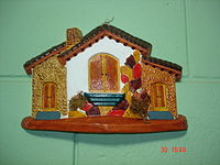
Arts
Fernando Llort
Fernando Llort Choussy is a Salvadoran artist of international recognition, called "El Salvador's National Artist" by the Foundation for Self-Sufficiency in Central America. He is known for teaching and inspiring the small town of La Palma, Chalatenango, how to make a living through art. His style...
developed the arts in the municipality, developing an artisan industry that is the main employer in La Palma.
There are around 100 crafts factories in the locality, half of which are dedicated to export
Export
The term export is derived from the conceptual meaning as to ship the goods and services out of the port of a country. The seller of such goods and services is referred to as an "exporter" who is based in the country of export whereas the overseas based buyer is referred to as an "importer"...
.
The growth of the artisan export in the municipality does not correspond to the national trend.
Agriculture
Coffee production is, according to the municipal economic report of 2006, the second most important industry in La Palma, although it has been decreasing due to the strong competition of foreign producers. In 1988, coffee production accounted for over half of El Salvador's revenue from exports, whereas for 2004 it has fallen dramatically to just 7%.Tourist attractions
- 13 kilometers outside La Palma town is Miramundo. It is located in the hill forest at an altitude of 2400 metres and is noted for its cool climate. The average temperature average of Miramundo is just 12°C.
- 3 kilometers away is San IgnacioSan Ignacio, ChalatenangoSan Ignacio is a municipality of El Salvador. Is located in the departament of Chalatenango, to a distance of 87 km. from San Salvador, and to 8 km. of the international border with Honduras.This municipality takes his name in honor to Ignatius of Loyola...
, a small town at 1010 metres. There are hotels and several organized tourist activities in the area. CitaláCitaláCitalá is a municipality in the Chalatenango department of El Salvador.-Church del Pilar-Citalá:It is located in Villa of Citalá, head of the municipality of the same name, 47 km from Chalatenango and in the suburbs of the frontier of Honduras. It has an elevation of 788 meters over sea level...
and the Lempa RiverLempa RiverThe Lempa River is a 422 km long river in Central America. Its sources are located in between the Sierra Madre and the Sierra del Merendón in southern Guatemala, near the town of Olopa. In Guatemala the river is called Río Olopa and flows southwards for 30.4 km before entering Honduras and...
are just a few minutes north of San Ignacio.
- Las Pilas is located in mountain forest of La Palma, with a very cold climate, even more so than Miramundo. The main agricultural products there are blackberries, strawberries, peachPeachThe peach tree is a deciduous tree growing to tall and 6 in. in diameter, belonging to the subfamily Prunoideae of the family Rosaceae. It bears an edible juicy fruit called a peach...
es, lettuceLettuceLettuce is a temperate annual or biennial plant of the daisy family Asteraceae. It is most often grown as a leaf vegetable. It is eaten either raw, notably in salads, sandwiches, hamburgers, tacos, and many other dishes, or cooked, as in Chinese cuisine in which the stem becomes just as important...
and cabbageCabbageCabbage is a popular cultivar of the species Brassica oleracea Linne of the Family Brassicaceae and is a leafy green vegetable...
s.
- The Cayahuanca StoneCayahuanca StoneThe Cayahuanca Stone is a stone located some 4 kilometers to the north of San Ignacio, Chalatenango on the border between Honduras and El Salvador, approximately 1550 metres above sea level...
(Piedra Cayahuanca ) is to 4 kilometers to the north of San Ignacio between HondurasHondurasHonduras is a republic in Central America. It was previously known as Spanish Honduras to differentiate it from British Honduras, which became the modern-day state of Belize...
and El Salvador, approximately 1550 metres above sea level. The rock marks the territorial border, giving a panoramic view of both countries. During EasterEasterEaster is the central feast in the Christian liturgical year. According to the Canonical gospels, Jesus rose from the dead on the third day after his crucifixion. His resurrection is celebrated on Easter Day or Easter Sunday...
, the local inhabitants and visitors meet at the point of Cayahuanca the Stone and camp overnight.
- El Pital is 12 kilometers from the town of La Palma. At a height of 2730 metres it is the highest point of the Salvadoran territory. It is a mountain in the middle of a cloudy forest that has an average annual temperature of 10°C. On April 13, 2004, the temperature hit record lows and much of the hill was covered by a frost and ice that caused commotion between the settlers, attributing the phenomenon to a supposed " nevada"