

Kolsås
Encyclopedia
Bærum
is a municipality in Akershus county, Norway. The administrative centre of the municipality is the town of Sandvika. Bærum was established as a municipality on 1 January 1838. A suburb of Oslo, Bærum is located on the west coast of the city....
, Norway
Norway
Norway , officially the Kingdom of Norway, is a Nordic unitary constitutional monarchy whose territory comprises the western portion of the Scandinavian Peninsula, Jan Mayen, and the Arctic archipelago of Svalbard and Bouvet Island. Norway has a total area of and a population of about 4.9 million...
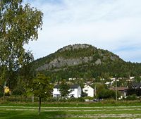
. Geologically, Kolsås belongs to the Oslo Graben
Oslo Graben
The Oslo Graben or Oslo Rift is a graben formed during a geologic rifting event in Permian time, the last phase of the Variscan orogeny. The main graben forming period began in the late Carboniferous, which culminated with rift formation and volcanism, with associated rhomb porphyry lava flows...
area. Its two peaks consist of hard rhomb porphyric lava
Lava
Lava refers both to molten rock expelled by a volcano during an eruption and the resulting rock after solidification and cooling. This molten rock is formed in the interior of some planets, including Earth, and some of their satellites. When first erupted from a volcanic vent, lava is a liquid at...
covering softer rocks, forming steep cliffs to the east, south and west.
The name
An old farm beneath the mountain has the name Kolsberg. The first element in this name is the genitive case of the old male name Kolr, and the last element is berg n 'mountain'. The parish and municipality of Bærum (Old NorseOld Norse
Old Norse is a North Germanic language that was spoken by inhabitants of Scandinavia and inhabitants of their overseas settlements during the Viking Age, until about 1300....
Bergheimr) is probably named after this prominent mountain. The last element in the name of the mountain was later changed to ås m 'mountain ridge' to distinguish it from the name of the farm.
Protected landscape area
The area from Kolsås to DælivannetDælivannet
Dælivannet is a lake in Bærum, Akershus county, Norway. It lies just beneath the Kolsås hill on the East side. The lake contains perch and pike and has a rich bird life....
is a protected landscape area from 1978 (five square kilometers), with four nature reserve
Nature reserve
A nature reserve is a protected area of importance for wildlife, flora, fauna or features of geological or other special interest, which is reserved and managed for conservation and to provide special opportunities for study or research...
s: Skotta, Dalbo, Kolsåsstupene and Kolsåstoppen nature reserve.
Climbing
Kolsås has been a training area for climbers since beginning of the 20th century. Today it is the largest rock climbingRock climbing
Rock climbing also lightly called 'The Gravity Game', is a sport in which participants climb up, down or across natural rock formations or artificial rock walls. The goal is to reach the summit of a formation or the endpoint of a pre-defined route without falling...
area in the Oslo region. The wall Øvre Sydstup on the southern wall has more than 200 climbing routes.
Winter sports
The northern hillside of Kolsås has alpine skiing facilities.Kolsåsbanen
KolsåsbanenKolsåsbanen
The Kolsås Line is a rapid transit line on the Oslo Metro network of Norway. It branches off from the Røa Line at Smestad, and runs to Kolsås; the terminus being from Stortinget. While the eastern part of the line is in Oslo, most of the line is in the neighboring municipality of Bærum...
is part of the subway rail system Oslo T-bane
Oslo T-bane
The Oslo Metro is the rapid transit system of Oslo, Norway, operated by Oslo T-banedrift on contract from the transit authority Ruter. The network consists of six lines that all run through the city centre, with a total length of . It has a daily ridership of 268,000 with 105 stations of which 16...
, running from downtown Oslo to Kolsås station
Kolsås (station)
Kolsås is the end station of the Kolsås Line on the Oslo Metro. The station, located in Bærum municipality, comes after Hauger, and is located from Stortinget....
, via Gjettum station
Gjettum (station)
Gjettum is a station on Kolsås Line of the Oslo Metro. It is located between Hauger and Valler at the foot of Kolsås, from Stortinget.The station was opened 1 January 1930 as part of the tramway Lilleaker Line....
and Hauger station
Hauger (station)
Hauger is a station on the Kolsås Line on the Oslo Metro system. It is between Kolsås and Gjettum, from Stortinget. It serves the neighborhood Hauger and the mainly industrial area Rud...
.
NATO base
The military base Kolsås leir, partly located inside the mountain, was home of NATO's Allied Forces Northern EuropeAllied Forces Northern Europe
Allied Forces Northern Europe was the most northern NATO command located at Kolsås outside Oslo. It was part of Allied Command Europe from around 1952 to 2003...
(AFNORTH) until 1994.
Culture
The area has occurrences of old petroglyphPetroglyph
Petroglyphs are pictogram and logogram images created by removing part of a rock surface by incising, picking, carving, and abrading. Outside North America, scholars often use terms such as "carving", "engraving", or other descriptions of the technique to refer to such images...
s, tumuli
Tumulus
A tumulus is a mound of earth and stones raised over a grave or graves. Tumuli are also known as barrows, burial mounds, Hügelgrab or kurgans, and can be found throughout much of the world. A tumulus composed largely or entirely of stones is usually referred to as a cairn...
and limestone
Limestone
Limestone is a sedimentary rock composed largely of the minerals calcite and aragonite, which are different crystal forms of calcium carbonate . Many limestones are composed from skeletal fragments of marine organisms such as coral or foraminifera....
quarries
Quarry
A quarry is a type of open-pit mine from which rock or minerals are extracted. Quarries are generally used for extracting building materials, such as dimension stone, construction aggregate, riprap, sand, and gravel. They are often collocated with concrete and asphalt plants due to the requirement...
.
The French painter Claude Monet
Claude Monet
Claude Monet was a founder of French impressionist painting, and the most consistent and prolific practitioner of the movement's philosophy of expressing one's perceptions before nature, especially as applied to plein-air landscape painting. . Retrieved 6 January 2007...
painted Mont Kolsaas in 1895.