

Ko Lan
Encyclopedia
Eastern Seaboard of Thailand
The Eastern Seaboard of Thailand is an emerging economic region, and plays a key role in Thailand's economy. Its importance lies in the fact that it is Thailand's center for export oriented industries. High value goods, such as Japanese branded automobiles, which are manufactured there and...
islands of Thailand
Thailand
Thailand , officially the Kingdom of Thailand , formerly known as Siam , is a country located at the centre of the Indochina peninsula and Southeast Asia. It is bordered to the north by Burma and Laos, to the east by Laos and Cambodia, to the south by the Gulf of Thailand and Malaysia, and to the...
.
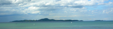
Geography
Ko Lan is the largest of the "Near Islands", off south PattayaPattaya
Pattaya is a city in Thailand, located on the east coast of the Gulf of Thailand, about 165 km southeast of Bangkok located within but not part of Amphoe Bang Lamung in the province of Chonburi....
. It is located at the SE end of the Bay of Bangkok
Bay of Bangkok
The Bay of Bangkok , also known as the Bight of Bangkok, is the northernmost part of the Gulf of Thailand, roughly extending from Hua Hin to the west and Sattahip to the east...
, on the eastern side of the Gulf of Siam. Administratively Ko Lan belongs to the Amphoe Bang Lamung
Amphoe Bang Lamung
Bang Lamung is a district in the southern part of Chonburi Province, Thailand.- History :Mueang Bang Lamung was located in Ban Bang Lamung, Tambon Bang Lamung. The government downgraded Bang Lamung to be a district, with the district office located on the bank of Khlong Nok Yang...
, Chonburi Province
Chonburi Province
Chonburi is a province of Thailand. Neighboring provinces are Chachoengsao, Chanthaburi and Rayong. To the west is the Gulf of Thailand. The eastern seaboard is heavily industrialized and underpinned by shipping, transportation, tourism, and manufacturing industries, and second to only Bangkok...
.
Ko Lan lies 8 km away from the nearest shore and it is about 4 km in length. It is a hilly island, covered with low tropical forest; its highest point reaches 205 m and there is a Buddhist shrine on top of the mountain. The island has two small villages on it: Ban Ko Lan and Ban Krok Makhan where there are lodgings and restaurants. There are ferries connecting Ko Lan to the mainland. Some local tour operators in nearby Pattaya organize picnic and snorkelling excursions to Ko Lan because there is a relaxed atmosphere and beaches with clear water. The ferry ride takes about 40 minutes. Ferries leave south Pattaya Bali Hai pier daily from 7:00 am to 6:30 pm, the one-way fare is 30 Baht. The return ferry leaves Koh Lan’s Na Ban Beach at 06.30 am to 6:00 pm.
Most of Ko Lan's beaches are on its western side. The most visited one is Tawaen Beach, where there is a small harbor. All the length of the beach is lined with small tourist shops behind which are dining halls of restaurants whose menu is based mainly on fish and seafood. Other beaches are Tonglang Beach, Tien Beach, Samae Beach and Naon Beach.
"Ko Lan" is the name of the island in the Royal Thai General System of Transcription. It is also known as "Koh Larn" in the English-based Thai transcription.
The "Koh Larn Classic" is a sailing and running race event held at the nearby Royal Varuna Yacht Club
Royal Varuna Yacht Club
The Royal Varuna Yacht Club is a yacht club in Pattaya, a popular tourist destination in Thailand. This club is named after Varuna , the Vedic divinity that rules the oceans.-History:...
in Pattaya.
Adjacent islands
Two smaller islands are located close to Ko Lan:- Ko Sak (เกาะสาก), a narrow "C"-shaped island with a small bay open towards the north. It is located 0.6 km off Ko Lan's northern tip. Highest point 33m. It has a horseshoe-shaped beach in the north. Accommodation is available.
- Ko Krok (เกาะครก), a private islandPrivate islandA private island is a disconnected body of land wholly owned by a single private citizen or corporation. Although this exclusivity gives the owner substantial control over the property, they still fall within the jurisdiction of national and sometimes local governments.-Ownership:There are many...
located less than 2 km to the east of Ko Lan's NE shore. Highest point 41 m.
Ko Phai
Ko Phai
Ko Phai is the largest island in Mu Ko Phai , a small uninhabited archipelago belonging to the Eastern Seaboard Islands of Thailand. It is located about 21 km to the west of Pattaya. It is also mentioned as "Bamboo Island", the meaning of its name in Thai, in tourist guides...
, the main island of Mu Ko Phai (หมู่เกาะไผ่), the group of "Far Islands", off Pattaya is located about 14 km to the west of Ko Lan.
External links
- thailand lonely planet - How to Travel From Bangkok to Koh Larn Pattaya by yourself