
Kirrawee, New South Wales
Encyclopedia
Suburb
The word suburb mostly refers to a residential area, either existing as part of a city or as a separate residential community within commuting distance of a city . Some suburbs have a degree of administrative autonomy, and most have lower population density than inner city neighborhoods...
in southern
Southern Sydney
This article refers to an area the same as a combination of St George and SutherlandSouthern Sydney is a general term which is used to describe the southern metropolitan area of Sydney, in the state of New South Wales, Australia....
Sydney
Sydney
Sydney is the most populous city in Australia and the state capital of New South Wales. Sydney is located on Australia's south-east coast of the Tasman Sea. As of June 2010, the greater metropolitan area had an approximate population of 4.6 million people...
, in the state of New South Wales
New South Wales
New South Wales is a state of :Australia, located in the east of the country. It is bordered by Queensland, Victoria and South Australia to the north, south and west respectively. To the east, the state is bordered by the Tasman Sea, which forms part of the Pacific Ocean. New South Wales...
, Australia
Australia
Australia , officially the Commonwealth of Australia, is a country in the Southern Hemisphere comprising the mainland of the Australian continent, the island of Tasmania, and numerous smaller islands in the Indian and Pacific Oceans. It is the world's sixth-largest country by total area...
. Kirrawee is located 25 kilometres south of the Sydney central business district
Sydney central business district
The Sydney central business district is the main commercial centre of Sydney, New South Wales, Australia. It extends southwards for about 3 kilometres from Sydney Cove, the point of first European settlement. Its north–south axis runs from Circular Quay in the north to Central railway station in...
in the Sutherland Shire
Sutherland Shire
The Sutherland Shire is a Local Government Area in the Southern Sydney region of Sydney, Australia. Geographically, it is the area to the south of Botany Bay and the Georges River...
. Kirrawee lies between Sutherland
Sutherland, New South Wales
Sutherland is a suburb in southern Sydney, in the state of New South Wales, Australia. Sutherland is located 26 kilometres south of the Sydney central business district and is the administrative centre for the local government area of the Sutherland Shire....
, to the west and Gymea
Gymea
Gymea may be a reference to:*Gymea, a suburb of Sydney in New South Wales, Australia*Gymea Bay, an adjacent suburb*the Gymea Lily, a flowing plant indigenous to coastal New South Wales...
and Grays Point
Grays Point, New South Wales
Grays Point is a suburb in southern Sydney, in the state of New South Wales, Australia. Grays Point is located 29 kilometres south of the Sydney central business district, in the local government area of the Sutherland Shire....
, to the east. Kirrawee's southern border is formed by The Royal National Park, while Kareela and Jannali form the northern border.
Kirrawee is split between commercial and residential areas. Approximately 90% of the area to the north of the train line is occupied by commercial and industrial properties while almost 100% of the area south of the train line is residential. South Kirrawee, which extends from the train line in the north to the Royal National Park
Royal National Park
Royal National Park is a national park in New South Wales, Australia, 29 km south of Sydney CBD.Founded by Sir John Robertson, Acting Premier of New South Wales, and formally proclaimed on 26 April 1879, it is the world's second oldest purposed national park, the first usage of the term...
in the south, has many houses on quiet roads with beautiful bush outlooks. North Kirrawee is predominantly a commercial/industrial zone containing small to medium factories housing local businesses. It is also home to a number of petrol stations, car dealerships and a fast food outlet. However, the most northerly and western sections of this part of Kirrawee are residential, with some parts also with bush outlooks.
History
Kirrawee is an AboriginalIndigenous Australians
Indigenous Australians are the original inhabitants of the Australian continent and nearby islands. The Aboriginal Indigenous Australians migrated from the Indian continent around 75,000 to 100,000 years ago....
word meaning 'lengthy'. The name was adopted in 1939 with the opening of the railway line. A postal receiving office in the locality was known as 'Bladesville'. It operated from the home of Mrs Louisa Blade, was opened in 1909 and closed in 1915 when a letter delivery service commenced from the post office at Sutherland
Sutherland, New South Wales
Sutherland is a suburb in southern Sydney, in the state of New South Wales, Australia. Sutherland is located 26 kilometres south of the Sydney central business district and is the administrative centre for the local government area of the Sutherland Shire....
.
Kirrawee, and all of southern Sydney
Sydney
Sydney is the most populous city in Australia and the state capital of New South Wales. Sydney is located on Australia's south-east coast of the Tasman Sea. As of June 2010, the greater metropolitan area had an approximate population of 4.6 million people...
, was inhabited by the Dharawal people for up to 8,000 years prior to European settlement.Early development was connected to the development of nearby Sutherland. It was not until the 1950s that Kirrawee became heavily settled with many families looking to resettle after World War II
World War II
World War II, or the Second World War , was a global conflict lasting from 1939 to 1945, involving most of the world's nations—including all of the great powers—eventually forming two opposing military alliances: the Allies and the Axis...
. Street names in Kirrawee commemorate notable Australians: Bligh and Putland, were named after the rum rebellion Governor Bligh and his daughter Mrs Putland; Meehan after an early surveyor; Johnston after a first fleet lieutenant; Kemp after a captain in charge of government stores; Gilmore after poet Dame Mary Gilmore.
Commercial area
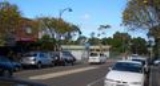
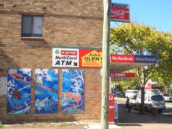
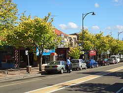
Kirrawee has a small shopping village on Oak Road, adjacent to the train station. It consists of a number of food outlets, newsagent, law firm, accountant, fruit shop and bike shop, among others. The train station and shopping village are located in the geographical centre of the suburb and are serviced by a 150 space carpark. A number of painted murals located around the shopping village and train station are an interesting feature in the suburb.Kirrawee Brickpit
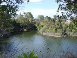
Kirrawee's disused "Brickpit" is a 4.5ha site just north of the main shopping village and its future has been the source of much debate by local residents, politicians, potential developers and media in the locality.Currently the deep brick pit covers approximately 50 - 60% of the total site and is half filled with water, making a natural lagoon
Lagoon
A lagoon is a body of shallow sea water or brackish water separated from the sea by some form of barrier. The EU's habitat directive defines lagoons as "expanses of shallow coastal salt water, of varying salinity or water volume, wholly or partially separated from the sea by sand banks or shingle,...
. It measures about 230metres long by about 80m wide and is about 16m deep. The remainder of the site is covered with overgrown trees and plants. The entire site is enclosed by a cyclone fence and there is no public access.
Used for industrial purposes between 1912 and 1979, the land was owned by various brick manufacturers, including Sutherland Brick Co, Refractory Bricks and Punchbowl Brick and Tile Co. Sydney Water Board acquired the land in 1974 for water-storage purposes but instead it became an equipment storage facility.
This site has been the subject of much controversy over recent years.
When it was evident Sydney Water had no use for the site and the State Government proposed to sell the site to developers for use as a mix of apartments, business units and a small park, Kirrawee Chamber of Commerce and a residents' group instead proposed the site be turned into a performing arts centre and large park.
In 2001, a 20 month program commenced to consult with the community about the future use of the site. This project was a joint initiative between the local council, the Department of Infrastructure, Planning and Natural Resources (DIPNR), Sydney Water
Sydney Water
Sydney Water is a New South Wales government owned corporation that provides drinking water, wastewater and some stormwater services to Sydney, Illawarra and the Blue Mountains, in Australia...
- the then owner of the site, and the local community. The Local Environment Plan (LEP) produced a master plan for the Kirrawee shopping village and brick pit which involved rezoning the site to a mix of commercial, residential and 20% open public space.
In April 2005, after the election of a new councillor, 45 amendments were passed with regards to the LEP. These amendments changed the zoning to make the Princes Highway
Princes Highway
The Princes Highway extends from Sydney to Port Augusta via the coast through the states of New South Wales, Victoria and South Australia, a distance of 1941 km or 1898 km via the former alignments of the highway ....
frontage commercial and the remainder "special uses". It was specifically noted that ...educational establishments are a permissible use in both zones.
Sutherland Shire Council moved to change the plan, but NSW state government Planning Minister Frank Sartor cemented the original proposal in a rewritten local environment plan.
In July 2007, a development group called Kirrawee Centre Pty Ltd, with directors including architect George Revay and brothers Stanley and John Roth, purchased the site from Sydney Water for $22.5million.
The State Government had previously said the buyer would have to develop it in accordance with a comprehensive master plan, which includes a mix of multi-storey apartments, business units and a one-hectare public park.
In May 2008 a new development application was proposed for the site including a shopping centre with 2 supermarkets and 63 apartments. http://www.sutherland.nsw.gov.au/ssc/home.nsf/WebPages/AD531E3EBC0BC402CA257441002432ED?OpenDocument&Expand=2
The development tick-tacked between council and the developer and eventually a far more commercially-based development proposal was lodged with the Land and Environment Court of NSW and heard over February, April, June and July 2009, with a judgement made on August 7, 2009.
In the case of Restifa Pty Ltd v Sutherland Shire Council & Ors [2009] NSWLEC 1267, the developer appealed against Council’s refusal of the development Masterplan for the site and of construction of Stage 1 for a mixed retail, commercial, residential development with a child care centre, basement car parking and open space recreation area. In the judgement, it was pointed out that during the course of the hearing there were many amendments and six sets of plans submitted. The retail component of the development was amended from the two supermarkets totalling about 7000 m2, with total retail 10,500 m2, to a proposal of one 4,500 m2 supermarket and total retail of about 8000m2. The development was ultimately rejected.
In July 2010, current owners Henroth Investments Pty Ltd bypassed Sutherland Shire Council, lodging a new development application with the NSW Planning Department for a $220 million, nine-storey development including nearly 500 residential units, over 13,500 square metres of retail space and 1378 car spaces.
The current application has 30 percent more units than the proposal refused by the Land and Environment Court in August 2009, which raised a number of concerns including the impact on retailers in Kirrawee and Sutherland, the design of the public open space, and the ecological impact.
Local retailer Superbarn was one of many to protest strongly, particularly after the group spent $18 million to develop a supermarket site in nearby Sutherland.
It is possible that the site will be approved by the current NSW government, however if not approved before the upcoming state election, the developers may yet be unsuccessful as the State opposition proposes returning decisions like this to local councils.
Transport
Kirrawee railway station is on the Cronulla branch of CityrailCityRail
CityRail is an operating brand of RailCorp, a corporation owned by the state government of New South Wales, Australia. It is responsible for providing commuter rail services, and some coach services, in and around Sydney, Newcastle and Wollongong, the three largest cities of New South Wales. It is...
's Illawarra Line which links Sydney
Sydney
Sydney is the most populous city in Australia and the state capital of New South Wales. Sydney is located on Australia's south-east coast of the Tasman Sea. As of June 2010, the greater metropolitan area had an approximate population of 4.6 million people...
's southern suburbs
Southern Sydney
This article refers to an area the same as a combination of St George and SutherlandSouthern Sydney is a general term which is used to describe the southern metropolitan area of Sydney, in the state of New South Wales, Australia....
to the CBD
Central business district
A central business district is the commercial and often geographic heart of a city. In North America this part of a city is commonly referred to as "downtown" or "city center"...
. Kirrawee is approximately 40 minutes by train to the CBD
Central business district
A central business district is the commercial and often geographic heart of a city. In North America this part of a city is commonly referred to as "downtown" or "city center"...
. Kirrawee was one of the last remaining single platform stations in Sydney
Sydney
Sydney is the most populous city in Australia and the state capital of New South Wales. Sydney is located on Australia's south-east coast of the Tasman Sea. As of June 2010, the greater metropolitan area had an approximate population of 4.6 million people...
. Duplication of the train line from Sutherland
Sutherland, New South Wales
Sutherland is a suburb in southern Sydney, in the state of New South Wales, Australia. Sutherland is located 26 kilometres south of the Sydney central business district and is the administrative centre for the local government area of the Sutherland Shire....
to Cronulla commenced in May 2006 and was completed in 2010. See Government Website.
Kirrawee has bus services operated by Veolia NSW which run down President Avenue and Waratah Street. Princes Highway services do not stop in Kirrawee.
Schools and churches
Education facilities within Kirrawee include Kirrawee High SchoolKirrawee High School
Kirrawee High School is a comprehensive co-educational high school located in Kirrawee NSW adjacent to the Royal National Park.The school was opened in 1968 and now caters for around 1200 students, most continuing their education from three local primary schools, Gymea Bay, Grays Point and Kirrawee...
and Kirrawee Public School, along with a number of pre-schools and childcare
Childcare
Child care means caring for and supervising child/children usually from 0–13 years of age. In the United States child care is increasingly referred to as early childhood education due to the understanding of the impact of early experiences of the developing child...
centres. Gymea Technology High School also lies on Kirrawee's outskirts.
St. Mary, St. Bakhomious and St. Shenouda Coptic Orthodox Church, located in Bath Road, was consecrated in 1996.
Politics
Kirrawee is part of the Sutherland ShireSutherland Shire
The Sutherland Shire is a Local Government Area in the Southern Sydney region of Sydney, Australia. Geographically, it is the area to the south of Botany Bay and the Georges River...
Government Area in Southern Sydney
Southern Sydney
This article refers to an area the same as a combination of St George and SutherlandSouthern Sydney is a general term which is used to describe the southern metropolitan area of Sydney, in the state of New South Wales, Australia....
. For local government purposes the Sutherland Shire is split into 5 wards, A through to E. These wards are reviewed every 4 years. Kirrawee is split between Ward B and Ward C by the Princes Highway
Princes Highway
The Princes Highway extends from Sydney to Port Augusta via the coast through the states of New South Wales, Victoria and South Australia, a distance of 1941 km or 1898 km via the former alignments of the highway ....
which runs east to west through the centre of the suburb.
In Federal parliament
Australian House of Representatives
The House of Representatives is one of the two houses of the Parliament of Australia; it is the lower house; the upper house is the Senate. Members of Parliament serve for terms of approximately three years....
, Kirrawee is again split over 2 electorates
Electorates in Australia
Electorates in Australia are geographically defined areas represented by a single elected Member of Parliament. Known officially as divisions at the federal level and electoral districts at the state and territory level, "electorates" are also commonly referred to as seats or constituencies.-See...
, Hughes
Division of Hughes
The Division of Hughes is an Australian Electoral Division in New South Wales. The division was created in 1955 and is named for Billy Hughes, who was Prime Minister of Australia 1915-23...
and Cook
Division of Cook
The Division of Cook is an Australian Electoral Division in New South Wales. The division was created in 1969 and is named for James Cook, who mapped the east coast of Australia in 1770. It is located in the southern suburbs of Sydney, including Caringbah, Cronulla, Miranda and Sylvania...
. All of Kirrawee, aside from a couple of streets, are within the Division of Cook
Division of Cook
The Division of Cook is an Australian Electoral Division in New South Wales. The division was created in 1969 and is named for James Cook, who mapped the east coast of Australia in 1770. It is located in the southern suburbs of Sydney, including Caringbah, Cronulla, Miranda and Sylvania...
. Both seats are presently held by the Liberal Party
Liberal Party of Australia
The Liberal Party of Australia is an Australian political party.Founded a year after the 1943 federal election to replace the United Australia Party, the centre-right Liberal Party typically competes with the centre-left Australian Labor Party for political office...
(2006).
At state
New South Wales Legislative Assembly
The Legislative Assembly, or lower house, is one of the two chambers of the Parliament of New South Wales, an Australian state. The other chamber is the Legislative Council. Both the Assembly and Council sit at Parliament House in the state capital, Sydney...
level, Kirrawee is located within the seat of Miranda
Electoral district of Miranda
Miranda is an electoral district of the Legislative Assembly in the Australian state of New South Wales. It is represented by Graham Annesley of the Liberal Party of Australia.-Members for Miranda:-Election results:...
, which is held by the Liberal Party
Liberal Party of Australia
The Liberal Party of Australia is an Australian political party.Founded a year after the 1943 federal election to replace the United Australia Party, the centre-right Liberal Party typically competes with the centre-left Australian Labor Party for political office...
.
Footnotes
1 History of Sutherland Shire Placenames2
Barry Collier 26 May 2005