
Kirk Fell
Encyclopedia
Kirk Fell is a fell
in the Western part of the English Lake District. It is situated between Great Gable
and Pillar
on the long ring of fells surrounding the valley
of Ennerdale
, and also stands over Wasdale
to the south. However, it is separated from its two higher neighbours by the low passes of Black Sail and Beck Head, giving it a high relative height and making it a Marilyn
, the thirteenth highest in the Lake District.
The direct ascent up the south western slope from Wasdale Head
is backbreakingly steep and the subject of an amusing drawing by Wainwright
. Usual ascents are by one of the aforementioned passes; alternatively one may climb Kirk Fell as part of the Mosedale Horseshoe, a walk on the fells surrounding Mosedale, a side-valley of Wasdale.
occupy a triangular sector of the Lake District, bordered by the River Cocker to the north east and Wasdale
to the south east. Westwards the hills diminish toward the coastal plain of Cumberland. At the central hub of the high country are Great Gable
and its satellites, while two principal ridges fan out on either flank of Ennerdale
, the western fells in effect being a great horseshoe around this long wild valley. Kirk Fell is the first on the southern arm.
The main watershed runs broadly westwards from Great Gable, dividing the headwaters of Ennerdale and Wasdale
. The main fells in this section are Kirk Fell, Pillar
, Scoat Fell
, Haycock and Caw Fell
, followed by the lower Lank Rigg
group.
Kirk Fell sits squarely at the head of Wasdale, rising between the main headstreams of Mosedale and Lingmell Becks. From this direction it appears as a truncated cone, steep sided with a wide level top. The flanks above Wasdale are unremittingly steep, 2000 ft (609.6 m) of grass and scree with little to break the monotony. The only stream on these slopes is Ill Gill, falling from the depression between the summit and the east top.
 To the west, between Kirk Fell and Pillar, is Black Sail Pass. This is a pedestrian route from Wasdale to Ennerdale, and from there onward via Scarth Gap to Buttermere
. A well graded path now used exclusively for leisure, it was once a thoroughfare for trade between the valleys. The summit of the pass at 1775 ft (541 m) is crossed by the Ennerdale Fence, a boundary marking the watershed around the head of the valley. Although some sections of the 'fence' are actually stone walls, that running over the top of Kirk Fell is only a remnant, marked by occasional posts.
The Ennerdale face of Kirk Fell has more features to offer, but due to the remoteness of the dalehead is much less familiar. A wall of rock rims the summit plateau, Boat How Crags to the east and Kirkfell Crags to the west. Between the two is the hollow of Baysoar Slack, the birthplace of Sail Beck. Below the crags the gradient is not quite as severe as on the Wasdale side, slopes running down to the bank of the River Liza. Kirk Fell does not have such a prominent position in Ennerdale, Great Gable standing at the head of the valley.
To the east of Kirk Fell is Beck Head (2,020 ft), the col
connecting to Great Gable. A small rocky spur, Rib End, runs down from the summit plateau to the tarns at the depression. Although prominently named on Ordnance Survey
maps, Beckhead Tarn is a small shallow pool with a bed of peat and submerged flags. A second smaller pool forms after heavy rain.
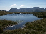
The summit plateau of Kirk Fell assumes a 'figure of eight' shape in plan, the narrow waist squeezed between Illgill Head and Baysoar Slack. The highest ground is to the west, while a subsidiary top occupies the other section. Kirk Fell east top has sufficient prominence (34 m, 112 ft) to qualify as a Hewitt in its own right. Between the summits is Kirkfell Tarn, actually two small tarns
. The deeper pool is an oval, while the other has an indented outline, reminiscent of Sprinkling Tarn on Seathwaite Fell
in miniature.
-phyric andesite
lava
s and subordinate sills of the Birker Fell Formation. The northern crags expose some granophyric granite
of the Ennerdale Intrusion, together with the bedded breccia
s, sandstone
s and tuff
s of the Round How Member.
set amid an area of stones. The east top has a cairn set on a rocky outcrop. Some remains of the old fence can be found on the watershed, crossing both tops.
Great Gable fills the eastern view, Gable Crag and the Napes seen in fascinating profile. Across Wasdale rise the Scafells
, while the High Stile
and Grasmoor
ranges are well seen in the other direction. There are also more distant glimpses of the Skiddaw
and Helvellyn range
s.
words "a relentless and unremitting treadmill, a turf clutching crawl, not a walk. There are only three opportunities of standing upright...". More conventional ascents can be made via Black Sail or Beck Head, the former providing easier gradients. Black Sail can also be used to give access from Ennerdale, although unless staying at Black Sail Youth Hostel, the nearest access in this direction is actually Gatesgarth via Scarth Gap.
Kirk Fell can also be climbed as part of the Mosedale Horseshoe, also taking in Yewbarrow
, Red Pike
, Scoat Fell
and Pillar
.
Fell
“Fell” is a word used to refer to mountains, or certain types of mountainous landscape, in Scandinavia, the Isle of Man, and parts of northern England.- Etymology :...
in the Western part of the English Lake District. It is situated between Great Gable
Great Gable
Great Gable is a mountain lying at the very heart of the English Lake District, appearing as a pyramid from Wasdale , but as a dome from most other directions. It is one of the most popular of the Lakeland fells, and there are many different routes to the summit...
and Pillar
Pillar (Lake District)
Pillar is a mountain in the western part of the English Lake District. Situated between the valleys of Ennerdale to the north and Wasdale to the south, it is the highest point of the Pillar group . At 892 metres it is the eighth highest mountain in the Lake District...
on the long ring of fells surrounding the valley
Valley
In geology, a valley or dale is a depression with predominant extent in one direction. A very deep river valley may be called a canyon or gorge.The terms U-shaped and V-shaped are descriptive terms of geography to characterize the form of valleys...
of Ennerdale
Ennerdale
Ennerdale may refer to:* Ennerdale, Gauteng, a suburb of Johannesburg, South Africa* Ennerdale Water, a lake in the Lake District in England**Ennerdale Bridge, a nearby settlement...
, and also stands over Wasdale
Wasdale
Wasdale is a valley and civil parish in the western part of the Lake District National Park in Cumbria, England. The River Irt flows through the valley to its estuary at Ravenglass. A large part of the main valley floor is occupied by Wastwater, the deepest lake in England...
to the south. However, it is separated from its two higher neighbours by the low passes of Black Sail and Beck Head, giving it a high relative height and making it a Marilyn
Marilyn (hill)
A Marilyn is a mountain or hill in the United Kingdom, Republic of Ireland or Isle of Man with a relative height of at least 150 metres , regardless of absolute height or other merit...
, the thirteenth highest in the Lake District.
The direct ascent up the south western slope from Wasdale Head
Wasdale Head
Wasdale Head is a small agricultural village in the Lake District National Park in Cumbria, England. The village claims to be home of the highest mountain , deepest lake , smallest church and biggest liar in England...
is backbreakingly steep and the subject of an amusing drawing by Wainwright
Alfred Wainwright
Alfred Wainwright MBE was a British fellwalker, guidebook author and illustrator. His seven-volume Pictorial Guide to the Lakeland Fells, published between 1955 and 1966 and consisting entirely of reproductions of his manuscript, has become the standard reference work to 214 of the fells of the...
. Usual ascents are by one of the aforementioned passes; alternatively one may climb Kirk Fell as part of the Mosedale Horseshoe, a walk on the fells surrounding Mosedale, a side-valley of Wasdale.
Topography
The Western FellsWestern Fells
The Western Fells are a group of hills in the English Lake District. Centred on Great Gable they occupy a triangular area between Buttermere and Wasdale...
occupy a triangular sector of the Lake District, bordered by the River Cocker to the north east and Wasdale
Wasdale
Wasdale is a valley and civil parish in the western part of the Lake District National Park in Cumbria, England. The River Irt flows through the valley to its estuary at Ravenglass. A large part of the main valley floor is occupied by Wastwater, the deepest lake in England...
to the south east. Westwards the hills diminish toward the coastal plain of Cumberland. At the central hub of the high country are Great Gable
Great Gable
Great Gable is a mountain lying at the very heart of the English Lake District, appearing as a pyramid from Wasdale , but as a dome from most other directions. It is one of the most popular of the Lakeland fells, and there are many different routes to the summit...
and its satellites, while two principal ridges fan out on either flank of Ennerdale
Ennerdale
Ennerdale may refer to:* Ennerdale, Gauteng, a suburb of Johannesburg, South Africa* Ennerdale Water, a lake in the Lake District in England**Ennerdale Bridge, a nearby settlement...
, the western fells in effect being a great horseshoe around this long wild valley. Kirk Fell is the first on the southern arm.
The main watershed runs broadly westwards from Great Gable, dividing the headwaters of Ennerdale and Wasdale
Wasdale
Wasdale is a valley and civil parish in the western part of the Lake District National Park in Cumbria, England. The River Irt flows through the valley to its estuary at Ravenglass. A large part of the main valley floor is occupied by Wastwater, the deepest lake in England...
. The main fells in this section are Kirk Fell, Pillar
Pillar (Lake District)
Pillar is a mountain in the western part of the English Lake District. Situated between the valleys of Ennerdale to the north and Wasdale to the south, it is the highest point of the Pillar group . At 892 metres it is the eighth highest mountain in the Lake District...
, Scoat Fell
Scoat Fell
Scoat Fell is a fell in the western part of the English Lake District. It stands at the head of the Mosedale Horseshoe with its back to Ennerdale...
, Haycock and Caw Fell
Caw Fell
Caw Fell is a fell in the English Lake District, standing between Haycock the Lank Rigg group. It occupies a wide upland area with Ennerdale to the north and Blengdale to the south...
, followed by the lower Lank Rigg
Lank Rigg
Lank Rigg is a fell in the English Lake District. It stands to the south of Ennerdale in the Western Fells. A sprawling hill with gentle grassy slopes it can be climbed from various points on the Coldfell road...
group.
Kirk Fell sits squarely at the head of Wasdale, rising between the main headstreams of Mosedale and Lingmell Becks. From this direction it appears as a truncated cone, steep sided with a wide level top. The flanks above Wasdale are unremittingly steep, 2000 ft (609.6 m) of grass and scree with little to break the monotony. The only stream on these slopes is Ill Gill, falling from the depression between the summit and the east top.
Buttermere
Buttermere is a lake in the English Lake District in North West England. The adjacent village of Buttermere takes its name from the lake. Historically within the former county of Cumberland, the lake is now within the county of Cumbria. It is owned by the National Trust, forming part of their...
. A well graded path now used exclusively for leisure, it was once a thoroughfare for trade between the valleys. The summit of the pass at 1775 ft (541 m) is crossed by the Ennerdale Fence, a boundary marking the watershed around the head of the valley. Although some sections of the 'fence' are actually stone walls, that running over the top of Kirk Fell is only a remnant, marked by occasional posts.
The Ennerdale face of Kirk Fell has more features to offer, but due to the remoteness of the dalehead is much less familiar. A wall of rock rims the summit plateau, Boat How Crags to the east and Kirkfell Crags to the west. Between the two is the hollow of Baysoar Slack, the birthplace of Sail Beck. Below the crags the gradient is not quite as severe as on the Wasdale side, slopes running down to the bank of the River Liza. Kirk Fell does not have such a prominent position in Ennerdale, Great Gable standing at the head of the valley.
To the east of Kirk Fell is Beck Head (2,020 ft), the col
Mountain pass
A mountain pass is a route through a mountain range or over a ridge. If following the lowest possible route, a pass is locally the highest point on that route...
connecting to Great Gable. A small rocky spur, Rib End, runs down from the summit plateau to the tarns at the depression. Although prominently named on Ordnance Survey
Ordnance Survey
Ordnance Survey , an executive agency and non-ministerial government department of the Government of the United Kingdom, is the national mapping agency for Great Britain, producing maps of Great Britain , and one of the world's largest producers of maps.The name reflects its creation together with...
maps, Beckhead Tarn is a small shallow pool with a bed of peat and submerged flags. A second smaller pool forms after heavy rain.
The summit plateau of Kirk Fell assumes a 'figure of eight' shape in plan, the narrow waist squeezed between Illgill Head and Baysoar Slack. The highest ground is to the west, while a subsidiary top occupies the other section. Kirk Fell east top has sufficient prominence (34 m, 112 ft) to qualify as a Hewitt in its own right. Between the summits is Kirkfell Tarn, actually two small tarns
Tarn (lake)
A tarn is a mountain lake or pool, formed in a cirque excavated by a glacier. A moraine may form a natural dam below a tarn. A corrie may be called a cirque.The word is derived from the Old Norse word tjörn meaning pond...
. The deeper pool is an oval, while the other has an indented outline, reminiscent of Sprinkling Tarn on Seathwaite Fell
Seathwaite Fell
Seathwaite Fell is an area of the Lake District in Cumbria, England. It stands above the hamlet of the same name at the head of Borrowdale.-Position of the summit:...
in miniature.
Geology
The summit area consists of drift deposits overlying the plagioclasePlagioclase
Plagioclase is an important series of tectosilicate minerals within the feldspar family. Rather than referring to a particular mineral with a specific chemical composition, plagioclase is a solid solution series, more properly known as the plagioclase feldspar series...
-phyric andesite
Andesite
Andesite is an extrusive igneous, volcanic rock, of intermediate composition, with aphanitic to porphyritic texture. In a general sense, it is the intermediate type between basalt and dacite. The mineral assemblage is typically dominated by plagioclase plus pyroxene and/or hornblende. Magnetite,...
lava
Lava
Lava refers both to molten rock expelled by a volcano during an eruption and the resulting rock after solidification and cooling. This molten rock is formed in the interior of some planets, including Earth, and some of their satellites. When first erupted from a volcanic vent, lava is a liquid at...
s and subordinate sills of the Birker Fell Formation. The northern crags expose some granophyric granite
Granite
Granite is a common and widely occurring type of intrusive, felsic, igneous rock. Granite usually has a medium- to coarse-grained texture. Occasionally some individual crystals are larger than the groundmass, in which case the texture is known as porphyritic. A granitic rock with a porphyritic...
of the Ennerdale Intrusion, together with the bedded breccia
Breccia
Breccia is a rock composed of broken fragments of minerals or rock cemented together by a fine-grained matrix, that can be either similar to or different from the composition of the fragments....
s, sandstone
Sandstone
Sandstone is a sedimentary rock composed mainly of sand-sized minerals or rock grains.Most sandstone is composed of quartz and/or feldspar because these are the most common minerals in the Earth's crust. Like sand, sandstone may be any colour, but the most common colours are tan, brown, yellow,...
s and tuff
Tuff
Tuff is a type of rock consisting of consolidated volcanic ash ejected from vents during a volcanic eruption. Tuff is sometimes called tufa, particularly when used as construction material, although tufa also refers to a quite different rock. Rock that contains greater than 50% tuff is considered...
s of the Round How Member.
Summit and view
The main top is marked by a cairnCairn
Cairn is a term used mainly in the English-speaking world for a man-made pile of stones. It comes from the or . Cairns are found all over the world in uplands, on moorland, on mountaintops, near waterways and on sea cliffs, and also in barren desert and tundra areas...
set amid an area of stones. The east top has a cairn set on a rocky outcrop. Some remains of the old fence can be found on the watershed, crossing both tops.
Great Gable fills the eastern view, Gable Crag and the Napes seen in fascinating profile. Across Wasdale rise the Scafells
Scafells
Image:Annotated Scafell range.jpg|thumb|right|300px|The Scafell range as seen looking west from Crinkle Crags. rect 23 372 252 419 Slight Side rect 173 794 560 834 Scafell East Buttress...
, while the High Stile
High Stile
High Stile is a mountain in the western part of the Lake District in northwest England. It is the eleventh highest English Marilyn, standing 807 metres high, and has a relative height of 362 metres ....
and Grasmoor
Grasmoor
Grasmoor is a mountain in the north-western part of the Lake District, northern England. It is the highest peak in a group of hills between the villages of Lorton, Braithwaite and Buttermere, and overlooks Crummock Water....
ranges are well seen in the other direction. There are also more distant glimpses of the Skiddaw
Skiddaw
Skiddaw is a mountain in the Lake District National Park in England. With a summit at 931 m above sea level it is the fourth highest mountain in England. It lies just north of the town of Keswick, Cumbria, and dominates the skyline in this part of the northern lakes...
and Helvellyn range
Helvellyn range
Helvellyn range is the name given to a part of the Eastern Fells in the English Lake District, fell being the local word for hill. The name comes from Helvellyn, the highest point of the group....
s.
Ascents
A path of sorts ascends direct from the village of Wasdale Head to the summit, the way being in Wainwright'sAlfred Wainwright
Alfred Wainwright MBE was a British fellwalker, guidebook author and illustrator. His seven-volume Pictorial Guide to the Lakeland Fells, published between 1955 and 1966 and consisting entirely of reproductions of his manuscript, has become the standard reference work to 214 of the fells of the...
words "a relentless and unremitting treadmill, a turf clutching crawl, not a walk. There are only three opportunities of standing upright...". More conventional ascents can be made via Black Sail or Beck Head, the former providing easier gradients. Black Sail can also be used to give access from Ennerdale, although unless staying at Black Sail Youth Hostel, the nearest access in this direction is actually Gatesgarth via Scarth Gap.
Kirk Fell can also be climbed as part of the Mosedale Horseshoe, also taking in Yewbarrow
Yewbarrow
Yewbarrow is a fell in the English Lake District which lies immediately north of the head of Wast Water. It is 628 metres high and in shape resembles the upturned hull of a boat or a barrow. Yewbarrow is on the left in the classic view of Great Gable and Wast Water.The top of Stirrup Crag...
, Red Pike
Red Pike (Wasdale)
Red Pike is a fell in the English Lake District. It is 826 m or high and lies due north of Wast Water. It is often climbed as part of the Mosedale Horseshoe, a walk which also includes Pillar....
, Scoat Fell
Scoat Fell
Scoat Fell is a fell in the western part of the English Lake District. It stands at the head of the Mosedale Horseshoe with its back to Ennerdale...
and Pillar
Pillar (Lake District)
Pillar is a mountain in the western part of the English Lake District. Situated between the valleys of Ennerdale to the north and Wasdale to the south, it is the highest point of the Pillar group . At 892 metres it is the eighth highest mountain in the Lake District...
.