

Kinoulton
Encyclopedia
Nottinghamshire
Nottinghamshire is a county in the East Midlands of England, bordering South Yorkshire to the north-west, Lincolnshire to the east, Leicestershire to the south, and Derbyshire to the west...
, England
England
England is a country that is part of the United Kingdom. It shares land borders with Scotland to the north and Wales to the west; the Irish Sea is to the north west, the Celtic Sea to the south west, with the North Sea to the east and the English Channel to the south separating it from continental...
. It is located 10 miles south east of the city of Nottingham
Nottingham
Nottingham is a city and unitary authority in the East Midlands of England. It is located in the ceremonial county of Nottinghamshire and represents one of eight members of the English Core Cities Group...
. According to the 2001 census it had a population of 1,037.
2004 estimates indicate a population of 990
The original settlement was close to the Roman Fosse Way
Fosse Way
The Fosse Way was a Roman road in England that linked Exeter in South West England to Lincoln in Lincolnshire, via Ilchester , Bath , Cirencester and Leicester .It joined Akeman Street and Ermin Way at Cirencester, crossed Watling Street at Venonis south...
, now the A46
A46 road
The A46 is an A road in England. It starts east of Bath, Somerset and ends in Cleethorpes, North East Lincolnshire, but it does not form a continuous route. Large portions of the old road have been lost, bypassed, or replaced by motorway development...
trunk road, just north of its junction with the present day A606 Nottingham to Melton Mowbray
Melton Mowbray
Melton Mowbray is a town in the Melton borough of Leicestershire, England. It is to the northeast of Leicester, and southeast of Nottingham...
road. It was close to the site of a civil war battle. Around the time when the Grantham Canal
Grantham Canal
The Grantham Canal is a canal that runs for 33 miles from Grantham, falling through 18 locks to West Bridgford where it joins the River Trent. It was built primarily to allow for the transportation of coal to Grantham. It opened in 1797, and its profitability steadily increased until 1841...
was opened in 1797, connecting the town of Grantham
Grantham
Grantham is a market town within the South Kesteven district of Lincolnshire, England. It bestrides the East Coast Main Line railway , the historic A1 main north-south road, and the River Witham. Grantham is located approximately south of the city of Lincoln, and approximately east of Nottingham...
in Lincolnshire with the River Trent
River Trent
The River Trent is one of the major rivers of England. Its source is in Staffordshire on the southern edge of Biddulph Moor. It flows through the Midlands until it joins the River Ouse at Trent Falls to form the Humber Estuary, which empties into the North Sea below Hull and Immingham.The Trent...
at Nottingham, the centre of the village migrated eastwards, downhill into the Vale of Belvoir
Vale of Belvoir
The Vale of Belvoir is an area of natural beauty on the borders of Leicestershire, Nottinghamshire and Lincolnshire in England. Indeed, the name itself derives from the Norman-French for beautiful view.-Extent and geology:...
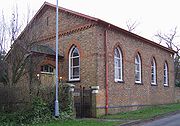
. A new parish church of St Luke was built for the Earl of Gainsborough
Earl of Gainsborough
Earl of Gainsborough is a title that has been created twice, once in the Peerage of England and once in the Peerage of the United Kingdom. The first creation ended in extinction when the sixth Earl died without heirs...
in 1792-93, close to the canal, and is a relatively rare example of a village parish church from this period. It is built in red brick, consisting of a nave and chancel, with a vestry to the north-east and a three-stage tower at the western end. It has been Grade II* listed since 1965. It replaced a church dedicated to St Wilfred which was located to the north of Kinoulton Lane. Although the building was demolished, the churchyard remains and contains a group of 34 headstones dating from the 1700s. The site of the village's pinfold
Pinfold
Pinfold, in Medieval Britain, is an area where stray animals were rounded up if their owners failed to properly supervise their use of common grazing land...
, where stray animals were kept if their owners failed to properly supervise their use of common grazing land, is adjacent to the new church, now only remembered in street names.
A moat 1 mile south of the village may have been the site of a grange of Launde Abbey in Leicestershire or Swineshead in Lincolnshire.
There is an ancient graveyard, with some graves dating back to 16th century. This is the graveyard of the settlement of Newbold, which was taken by the plague. Near it is Vimy Ridge Farmhouse, which is broken down and derlict. Evidence would show that disreputable youths have fires in the said place and smash glass bottles against walls, which can endanger passers by, and their dogs (especially Jack russells)