
Kingsland, London
Encyclopedia
Middlesex
Middlesex is one of the historic counties of England and the second smallest by area. The low-lying county contained the wealthy and politically independent City of London on its southern boundary and was dominated by it from a very early time...
. It has now been subsumed within inner city
Inner city
The inner city is the central area of a major city or metropolis. In the United States, Canada, United Kingdom and Ireland, the term is often applied to the lower-income residential districts in the city centre and nearby areas...
London
London
London is the capital city of :England and the :United Kingdom, the largest metropolitan area in the United Kingdom, and the largest urban zone in the European Union by most measures. Located on the River Thames, London has been a major settlement for two millennia, its history going back to its...
, principally as part of Dalston
Dalston
Dalston is a district of north-east London, England, located in the London Borough of Hackney. It is situated northeast of Charing Cross. The area is identified in the London Plan as one of 35 major centres in Greater London...
in the London Borough of Hackney
London Borough of Hackney
The London Borough of Hackney is a London borough of North/North East London, and forms part of inner London. The local authority is Hackney London Borough Council....
and has lost its separate identity.
Origins
Kingsland derives its name from being the hunting grounds of a Tudor royal residence at Newington GreenNewington Green
Newington Green is an open space in north London which straddles the border between Islington and Hackney. It gives its name to the surrounding area, roughly bounded by Ball's Pond Road to the south, Petherton Road to the west, the southern section of Stoke Newington with Green Lanes-Matthias Road...
—hence King's Lands. At the time, the area was still heavily forested—as part of a forest stretching from Shoreditch
Shoreditch
Shoreditch is an area of London within the London Borough of Hackney in England. It is a built-up part of the inner city immediately to the north of the City of London, located east-northeast of Charing Cross.-Etymology:...
to Enfield Chase
Enfield Chase
Enfield Chase is an area in the London Borough of Enfield, North London. It was once covered by woodland and used as a royal deer park. While it is no longer officially a 'place', the Church of England Parish of St Mary Magdalene, Enfield Chase, officially holds that title, which was effectively...
—and roamed by wild bulls, stags and wild boars. Deforestation occurred quickly – as the demands of the nearby City took wood for building and firewood; and the cleared land was quarried for brick clay. There were many wells and springs in the district. The (now lost) Pigwell Brook, had its source on Kingsland Green and followed the line of the modern Graham Road, before joining Hackney Brook
Hackney Brook
The Hackney Brook is one of the subterranean rivers of London. It crossed the northern parts of the current London boroughs of Hackney and Islington, emptying into the River Lea at Hackney Wick, with its source in Holloway.- Course of the River :...
in the region of Church Street (now, the Narroway). Another chalybeate spring beyond Dalston was tapped and water piped to Aldgate
Aldgate
Aldgate was the eastern most gateway through London Wall leading from the City of London to Whitechapel and the east end of London. Aldgate gives its name to a ward of the City...
, in 1535.
The small villages of Kingsland, Dalston
Dalston
Dalston is a district of north-east London, England, located in the London Borough of Hackney. It is situated northeast of Charing Cross. The area is identified in the London Plan as one of 35 major centres in Greater London...
, Newington
Newington Green
Newington Green is an open space in north London which straddles the border between Islington and Hackney. It gives its name to the surrounding area, roughly bounded by Ball's Pond Road to the south, Petherton Road to the west, the southern section of Stoke Newington with Green Lanes-Matthias Road...
and Shacklewell
Shacklewell
Shacklewell is a district within the London Borough of Hackney, roughly North-east of modern-day Dalston, .-History:...
were all situated within the Parish of Hackney
Hackney (parish)
Hackney was a parish in the historic county of Middlesex. The parish church of St John-at-Hackney was built in 1789, replacing the nearby former 16th century parish church dedicated to St Augustine . The original tower of that church was retained to hold the bells until the new church could be...
and were grouped together for assessment purposes. Together they had only as many houses as the village of Hackney
Hackney Central
Hackney Central is the central district of the London Borough of Hackney in London, England. It comprises the area roughly surrounding, and extending north from Mare Street. It is situated north east of Charing Cross...
. In 1672, Kingsland had 28 householders assessed for hearth tax, but expanded rapidly in the 18th century, along the line of Kingsland Road, north of the junction; and by 1724 had five inn
INN
InterNetNews is a Usenet news server package, originally released by Rich Salz in 1991, and presented at the Summer 1992 USENIX conference in San Antonio, Texas...
s, compared to Dalston's two. The road was heavily trafficked, including goods wagons pulled by six, or more horses, and this caused the state of the road to deteriorate. The local parishes appealed to Parliament in 1713 for the right to set up a Turnpike Trust
Turnpike trust
Turnpike trusts in the United Kingdom were bodies set up by individual Acts of Parliament, with powers to collect road tolls for maintaining the principal highways in Britain from the 17th but especially during the 18th and 19th centuries...
, to pay for the maintenance. Gates were installed at Kingsland and Stamford Hill
Stamford Hill
Stamford Hill is a place in the north of the London Borough of Hackney, England, near the border with Haringey. It is home to Europe's largest Hasidic Jewish and Adeni Jewish community.Stamford Hill is NNE of Charing Cross.-History:...
to collect the tolls. The village was still very rural, with market garden
Market gardening
A market garden is the relatively small-scale production of fruits, vegetables and flowers as cash crops, frequently sold directly to consumers and restaurants. It is distinguishable from other types of farming by the diversity of crops grown on a small area of land, typically, from under one acre ...
s established around the village. Large scale development began in 1807; again by the main road and a new estate was created on Lamb farm – to the south and west of the junction. By 1831, building began along Dalston Lane—linking the two villages.
In his youth, Samuel Pepys
Samuel Pepys
Samuel Pepys FRS, MP, JP, was an English naval administrator and Member of Parliament who is now most famous for the diary he kept for a decade while still a relatively young man...
lodged in the village, for a while with his brother Tom and his nurse, Goody Lawrence. Also, it is recorded that Pepys "used to shoot with bow and arrows" here in the 17th century.
Kingsland had a six-penny bath and a leper hospital, south of the green; also known as the 'Lock Hospital'. This was founded in 1280, by the City of London
City of London
The City of London is a small area within Greater London, England. It is the historic core of London around which the modern conurbation grew and has held city status since time immemorial. The City’s boundaries have remained almost unchanged since the Middle Ages, and it is now only a tiny part of...
, as one of ten located on the main roads from the City. This continued until 1559 and the last case of leprosy in London. From 1549, it was administered by St Bartholomew's Hospital
St Bartholomew's Hospital
St Bartholomew's Hospital, also known as Barts, is a hospital in Smithfield in the City of London, England.-Early history:It was founded in 1123 by Raherus or Rahere , a favourite courtier of King Henry I...
, and treated other infectious diseases. After the Great Fire
Great Fire of London
The Great Fire of London was a major conflagration that swept through the central parts of the English city of London, from Sunday, 2 September to Wednesday, 5 September 1666. The fire gutted the medieval City of London inside the old Roman City Wall...
, St Bartholomew's no longer had the funds to support the Lock hospital; but patients were accepted if they could fund their own care – this continued until 1680, when again the main hospital was able to resume funding. By 1669, there were six wards, now for women only – male patients were sent to Southwark
Southwark
Southwark is a district of south London, England, and the administrative headquarters of the London Borough of Southwark. Situated east of Charing Cross, it forms one of the oldest parts of London and fronts the River Thames to the north...
. The hospital was rebuilt in 1720, but closed in 1760. The hospital had a chapel, dedicated to St Bartholomew. This was used, informally, as a chapel of ease
Chapel of ease
A chapel of ease is a church building other than the parish church, built within the bounds of a parish for the attendance of those who cannot reach the parish church conveniently....
, saving residents the walk to church at the parish church in Hackney
St Augustine's Tower Hackney
St Augustine's Tower stands in St John's Church Gardens, in Hackney Central, in the London Borough of Hackney, just off the southern end of the Narrow Way . It is all that remains of the early 16th century parish church of Hackney of St Augustine, which replaced the 13th century medieval church...
. At the closure of the hospital, local people petitioned to keep the chapel open; it was never repaired and was in poor condition in the 1820s, being demolished in 1846.
Disappearing district

Queensbridge (ward)
Queensbridge is a ward in the London Borough of Hackney and forms part of the Hackney South and Shoreditch constituency.The ward returns three councillors to Borough Council, with an election every four years. At the last election on 6 May 2010, Emma Plouviez, Tom Price, and Patrick Vernon, all...
within the Borough of Hackney.
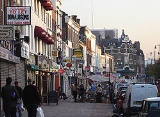
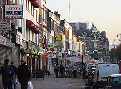
Before the arrival of the railways, in about 1850, Kingsland was the dominant village; and why the section of the A10 road that is modern Dalston's main shopping centre is Kingsland High Street, and why Kingsland Road
Kingsland Road
Kingsland Road is the name of a road, part of the A10, in the London Borough of Hackney in England. It runs from the junction with Old Street and Hackney Road north to the junction with Balls Pond Road and Dalston Lane, where it changes its name to Kingsland High Street...
, not Dalston Road, extends south from the junction. Dalston was overshadowed by Kingsland at this time, and was a less important settlement ranged along that part of Dalston Lane to the north of Graham Road.
The North London Railway
North London Railway
The North London Railway was a railway company that opened lines connecting the north of London to the East and West India Docks. The main east to west route is now part the North London Line. Other lines operated by the company fell into disuse, but were later revived as part of the Docklands...
arrived in 1865, and adopted 'Dalston Junction' as the name of the junction and new station —one of the most important on the line, since it connected directly with the City
City of London
The City of London is a small area within Greater London, England. It is the historic core of London around which the modern conurbation grew and has held city status since time immemorial. The City’s boundaries have remained almost unchanged since the Middle Ages, and it is now only a tiny part of...
. Thus Kingsland's fate was sealed. Over time, the area round the junction became known by the name of the station—a common phenomenon in London—though simple 'Dalston' was reserved for the area around the original settlement. In 1986, the closure of Dalston Junction station and its route to the city might have spelled a reprieve for Kingsland, since it was replaced with a new east-west station called Dalston Kingsland
Dalston Kingsland railway station
Dalston Kingsland railway station is a railway station on the North London Line in London, England. It is in the Dalston area of the London Borough of Hackney, on the western side of Kingsland High Street and opposite Ridley Road Market. The station and all trains serving it are operated by London...
. But it was not to be—the result was that people simply dropped the 'Junction', effectively moving the centre of Dalston a kilometre west and putting the last nail in Kingsland's coffin.
Although the A-Z (2005) still assigns Kingsland a place just southwest of Dalston Junction, this area became lost to Kingsland a long time ago—it is, in fact, part of De Beauvoir Town
De Beauvoir Town
De Beauvoir Town is a district of the London Borough of Hackney that partly falls within the London Borough of Islington. Its borders are Kingsland Road in the east, Southgate Road to the west, the Regent's Canal in the south and Tottenham Road to the north...
, a later settlement than either Kingsland or Dalston, but one that runs all the way north to the Balls Pond Road. The picture right shows the Trolley Stop pub (just under the 'D' of Kingsland in the 2005 A-Z on Stamford Road), however the wrought iron work betrays the pub's original identity as The De Beauvoir Arms. And about 100 metres to the west is the De Beauvoir Primary School.
Education
Transport and locale

London Overground
London Overground is a suburban rail network in London and Hertfordshire. It has been operated by London Overground Rail Operations since 2007 as part of the National Rail network, under the franchise control and branding of Transport for London...
are Dalston Junction
Dalston Junction railway station
Dalston Junction railway station is in the Dalston area of the London Borough of Hackney at the crossroad of Dalston Lane, Kingsland Road and Balls Pond Road...
and Haggerston
Haggerston railway station
Haggerston railway station is in the London Borough of Hackney, in London. The station is located on the Kingsland Viaduct in the Haggerston district at the junction of Arbutus Street and Frederick Terrace, near Kingsland Road. The main entrance is in Lee Street...
External links
- Brickfields (Hackney History project) Kingsland Road