

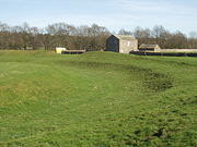
King Arthur's Round Table, Cumbria
Encyclopedia
Neolithic
The Neolithic Age, Era, or Period, or New Stone Age, was a period in the development of human technology, beginning about 9500 BC in some parts of the Middle East, and later in other parts of the world. It is traditionally considered as the last part of the Stone Age...
henge
Henge
There are three related types of Neolithic earthwork which are all sometimes loosely called henges. The essential characteristic of all three types is that they feature a ring bank and ditch but with the ditch inside the bank rather than outside...
in the village of Eamont Bridge
Eamont Bridge
Eamont Bridge is a small village immediately to the south of Penrith, Cumbria.The village is named after the River Eamont and straddles the boundary between the ancient counties of Cumberland and Westmorland...
within the English
England
England is a country that is part of the United Kingdom. It shares land borders with Scotland to the north and Wales to the west; the Irish Sea is to the north west, the Celtic Sea to the south west, with the North Sea to the east and the English Channel to the south separating it from continental...
county of Cumbria
Cumbria
Cumbria , is a non-metropolitan county in North West England. The county and Cumbria County Council, its local authority, came into existence in 1974 after the passage of the Local Government Act 1972. Cumbria's largest settlement and county town is Carlisle. It consists of six districts, and in...
, around 2 km south east of Penrith
Penrith, Cumbria
Penrith was an urban district between 1894 and 1974, when it was merged into Eden District.The authority's area was coterminous with the civil parish of Penrith although when the council was abolished Penrith became an unparished area....
. The site is free to visitors and is under the control of English Heritage
English Heritage
English Heritage . is an executive non-departmental public body of the British Government sponsored by the Department for Culture, Media and Sport...
.
The henge is around 90m in diameter
Diameter
In geometry, a diameter of a circle is any straight line segment that passes through the center of the circle and whose endpoints are on the circle. The diameters are the longest chords of the circle...
with two original entrances of which only that in the south-east survives due to modern road truncation. The external bank is 1.5m high with an internal quarry ditch which was 9m wide, flat bottomed and 1.4m deep when excavated in the 1937 and 1939. William Stukeley
William Stukeley
William Stukeley FRS, FRCP, FSA was an English antiquarian who pioneered the archaeological investigation of the prehistoric monuments of Stonehenge and Avebury, work for which he has been remembered as "probably... the most important of the early forerunners of the discipline of archaeology"...
recorded two standing stone
Standing stone
Standing stones, orthostats, liths, or more commonly megaliths are solitary stones set vertically in the ground and come in many different varieties....
s outside the northern entrance although these are no longer visible.

Attempts to turn the site into a landscaped garden in the 19th century have also caused disturbance and created a raised plateau in the centre. A cremation trench was identified in the middle during the excavations in the 1930s. It was 2.4m long, 0.8m wide and just 0.25m deep, contained cremated bone and may have been covered by a stone structure although little remained for analysis.
Another henge called the Little Round Table stood 200m to the south but was destroyed in the 19th century. The better preserved henge at Mayburgh
Mayburgh Henge
Mayburgh Henge is a large prehistoric monument in the county of Cumbria in northern England. Mayburgh Henge is just outside the village of Eamont Bridge close to the confluence of the Rivers Eamont and Lowther around 1 mile south of Penrith, just a few hundred yards from the M6 motorway.Mayburgh...
is also very close by, indicating the presence of a henge complex and possible ritual landscape similar to those at Thornborough or Salisbury Plain
Salisbury Plain
Salisbury Plain is a chalk plateau in central southern England covering . It is part of the Southern England Chalk Formation and largely lies within the county of Wiltshire, with a little in Hampshire. The plain is famous for its rich archaeology, including Stonehenge, one of England's best known...
.
External links
- Britain Express online
- JSTOR online journal