
King's Lynn and West Norfolk
Encyclopedia
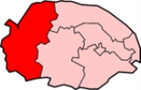
King's Lynn and West Norfolk is a local government district
and borough
in Norfolk
, England
. Its council is based in the town of King's Lynn
.
, Hunstanton
and Downham Market
urban district
s along with Docking Rural District, Downham Rural District, Freebridge Lynn Rural District
and Marshland Rural District. The district was originally known as just West Norfolk, and adopted its present name in 1981.
, the district had an area of 1,473 km²
, of which 28 km²
was in the urban area and 1,445 km²
in the surrounding parishes. The district had a population of 135,345 in 58,338 households, with 34,564 in 15,285 households living in the urban area, whilst 100,781 people in 43,053 households lived in the surrounding parishes.
The urban area of King's Lynn itself is unparished. The remainder of the district lies within the following civil parishes:
Non-metropolitan district
Non-metropolitan districts, or colloquially shire districts, are a type of local government district in England. As created, they are sub-divisions of non-metropolitan counties in a so-called "two-tier" arrangement...
and borough
Borough
A borough is an administrative division in various countries. In principle, the term borough designates a self-governing township although, in practice, official use of the term varies widely....
in Norfolk
Norfolk
Norfolk is a low-lying county in the East of England. It has borders with Lincolnshire to the west, Cambridgeshire to the west and southwest and Suffolk to the south. Its northern and eastern boundaries are the North Sea coast and to the north-west the county is bordered by The Wash. The county...
, England
England
England is a country that is part of the United Kingdom. It shares land borders with Scotland to the north and Wales to the west; the Irish Sea is to the north west, the Celtic Sea to the south west, with the North Sea to the east and the English Channel to the south separating it from continental...
. Its council is based in the town of King's Lynn
King's Lynn
King's Lynn is a sea port and market town in the ceremonial county of Norfolk in the East of England. It is situated north of London and west of Norwich. The population of the town is 42,800....
.
History
The district was formed in 1974 by the merger of the Municipal Borough of King's LynnKing's Lynn
King's Lynn is a sea port and market town in the ceremonial county of Norfolk in the East of England. It is situated north of London and west of Norwich. The population of the town is 42,800....
, Hunstanton
Hunstanton
Hunstanton, often pronounced by locals as and known colloquially as 'Sunny Hunny', is a seaside town in Norfolk, England, facing The Wash....
and Downham Market
Downham Market
Downham Market is a town and civil parish in Norfolk, England. It lies on the edge of the Fens, on the River Great Ouse, some 20 km south of the town of King's Lynn, 60 km west of the city of Norwich and the same distance north of the city of Cambridge....
urban district
Urban district
In the England, Wales and Ireland, an urban district was a type of local government district that covered an urbanised area. Urban districts had an elected Urban District Council , which shared local government responsibilities with a county council....
s along with Docking Rural District, Downham Rural District, Freebridge Lynn Rural District
Freebridge Lynn Rural District
Freebridge Lynn Rural District was a rural district in Norfolk, England from 1894 to 1974.It was formed under the Local Government Act 1894 based on the Freebridge Lynn rural sanitary district, and was named after the Freebridge Lynn hundred...
and Marshland Rural District. The district was originally known as just West Norfolk, and adopted its present name in 1981.
Composition
The district comprises the urban area of King's Lynn itself, together with 102 surrounding parishes. At the time of the 2001 censusUnited Kingdom Census 2001
A nationwide census, known as Census 2001, was conducted in the United Kingdom on Sunday, 29 April 2001. This was the 20th UK Census and recorded a resident population of 58,789,194....
, the district had an area of 1,473 km²
1 E9 m²
To help compare orders of magnitude of different geographical regions, we list here areas between 1,000 km2 and 10,000 km2. See also areas of other orders of magnitude.* areas less than 1000 km2* 1,000 km2 is equal to:...
, of which 28 km²
1 E7 m²
To help compare sizes of different geographic regions, we list here areas between 10 km2 and 100 km2...
was in the urban area and 1,445 km²
1 E9 m²
To help compare orders of magnitude of different geographical regions, we list here areas between 1,000 km2 and 10,000 km2. See also areas of other orders of magnitude.* areas less than 1000 km2* 1,000 km2 is equal to:...
in the surrounding parishes. The district had a population of 135,345 in 58,338 households, with 34,564 in 15,285 households living in the urban area, whilst 100,781 people in 43,053 households lived in the surrounding parishes.
The urban area of King's Lynn itself is unparished. The remainder of the district lies within the following civil parishes:
- AnmerAnmer, NorfolkAnmer is a small village and civil parish in the English county of Norfolk, situated about 12 miles north by north-east of the town of King's Lynn, and 35 miles north-west of the city of Norwich...
- Bagthorpe with BarmerBagthorpe with BarmerBagthorpe with Barmer is a civil parish in the English county of Norfolk. The parish includes the hamlets of Bagthorpe and Barmer, and is situated some 15 km west of Fakenham and 20 km north east of King's Lynn....
, Barton BendishBarton BendishBarton Bendish is a village and a civil parish in the English county of Norfolk. The village is east of Downham Market, west of Norwich and north-east of London. The village lies south of the town of Kings Lynn.The nearest railway station is at Downham Market for the Fen Line which runs...
, BarwickBarwick, NorfolkBarwick is a hamlet and civil parish in the English county of Norfolk. It is situated adjacent to the slightly larger village of Stanhoe, some 30 km north-east of the town of King's Lynn and 60 km north-west of the city of Norwich....
, BawseyBawseyBawsey is a village and civil parish in the English county of Norfolk. The village is about 4 miles east of the town of King's Lynn and 40 miles west of the city of Norwich...
, BirchamBirchamBircham is a civil parish in the English county of Norfolk. It includes the three villages of Great Bircham, Bircham Newton and Bircham Tofts...
, BoughtonBoughton, NorfolkBoughton is a village and a civil parish in the English county of Norfolk. The village is west of Norwich, south-south-west of King’s Lynn and north-east of London. The nearest town is Downham Market which is east of the village. The village is a north of the route A134 which links King’s Lynn...
, BrancasterBrancasterBrancaster is a village and civil parish on the north coast of the English county of Norfolk. The civil parish of Brancaster comprises Brancaster itself, together with Brancaster Staithe and Burnham Deepdale...
, Burnham MarketBurnham MarketBurnham Market is a village with and civil parish near the north coast of Norfolk, England. Burnham Market is one of the Burnhams, a group of adjacent villages in North Norfolk...
, Burnham NortonBurnham NortonBurnham Norton is a village and civil parish in the English county of Norfolk. Burnham Norton is one of the Burnhams, a group of adjacent villages in North Norfolk...
, Burnham OveryBurnham OveryBurnham Overy is a civil parish on the north coast of Norfolk, England. In modern times a distinction is often made between the two settlements of Burnham Overy Town, the original village adjacent to the parish church and now reduced to a handful of houses, and Burnham Overy Staithe, a rather...
, Burnham ThorpeBurnham ThorpeBurnham Thorpe is a small village and civil parish on the River Burn and near the coast of Norfolk in the United Kingdom. It is famous for being the birthplace of Vice Admiral Horatio Nelson, victor at the Battle of Trafalgar and one of Britain's greatest heroes... - Castle AcreCastle AcreCastle Acre is a village and civil parish in the English county of Norfolk. The village is situated on the River Nar some north of the town of Swaffham...
, Castle RisingCastle RisingCastle Rising is a village and civil parish in the English county of Norfolk. It is best known as the location of Castle Rising Castle, which dominates the village...
, ChoseleyChoseleyChoseley is a tiny hamlet and civil parish in the English county of Norfolk. It is situated between the villages of Titchwell and Docking and about from each...
, ClenchwartonClenchwartonClenchwarton is a village and civil parish in the English county of Norfolk. It is located on the west side of the River Great Ouse, about 2 km from the river and from the town of King's Lynn on the east side of the river....
, ConghamConghamCongham is a village and civil parish in the English county of Norfolk. It is situated some 10 km west of the town of King's Lynn and 55 km west of the city of Norwich....
, CrimpleshamCrimpleshamCrimplesham is a village and civil parish in the English county of Norfolk. It is situated 4 km west of the small town of Downham Market, 20 km south of the larger town of King's Lynn, and 60 km west of the city of Norwich.... - DenverDenver, NorfolkDenver is a village and civil parish in the English county of Norfolk. It is located on the River Great Ouse, 1 mile south of the small town of Downham Market, 14 miles south of the larger town of King's Lynn, and 37 miles west of the city of Norwich.The civil parish has an area of...
, DersinghamDersinghamDersingham is a village and civil parish in the English county of Norfolk. It is situated some north of the town of King's Lynn and north-west of the city of Norwich, opening onto the Wash....
, DockingDocking, NorfolkDocking is a village and civil parish in the English county of Norfolk and contains the highest point in North West Norfolk.It covers an area of and had a population of 1,150 in 469 households as of the 2001 census....
, Downham MarketDownham MarketDownham Market is a town and civil parish in Norfolk, England. It lies on the edge of the Fens, on the River Great Ouse, some 20 km south of the town of King's Lynn, 60 km west of the city of Norwich and the same distance north of the city of Cambridge....
, Downham WestDownham WestDownham West is a civil parish in the English county of Norfolk The parish is west of Norwich, south-south-west of King's Lynn and north of London. The nearest town is Downham Market which is north east of the parish. The nearest railway station is at Downham Market for the Fen Line which runs... - East RudhamEast RudhamEast Rudham is a village and civil parish in the English county of Norfolk. It covers an area of and had a population of 525 in 240 households as of the 2001 census....
, East WaltonEast WaltonEast Walton is a civil parish in the English county of Norfolk.It covers an area of and had a population of 90 in 40 households as of the 2001 census.For the purposes of local government, it falls within the district of King's Lynn and West Norfolk....
, East WinchEast WinchEast Winch is a civil parish in the English county of Norfolk, a few miles southeast of King's LynnIt covers an area of and had a population of 782 in 325 households as of the 2001 census....
, EmnethEmnethEmneth is a village and a civil parish in the English county of Norfolk. The village is west of Norwich, south-west of King's Lynn and north of London. The nearest town is Wisbech which is north-north-west of the village. The Village lies to the south-west of the route of the A47 between... - FeltwellFeltwellFeltwell is a village 10 miles west of Thetford, Norfolk, England, and is in the borough of King's Lynn and West Norfolk.Feltwell is a small village with a thriving community. The village has a small primary school which was originally built as a hospital. The pubs, The Lodge and the West End, are...
, Fincham, Flitcham with AppletonFlitcham with AppletonFlitcham with Appleton is a civil parish in the English county of Norfolk.It covers an area of and had a population of 236 in 96 households as of the 2001 census....
, FordhamFordham, NorfolkFordham is a small village and civil parish in the English county of Norfolk between Hilgay and Denver near the town of Downham Market. The parish falls in the district of King's Lynn and West Norfolk...
, FringFring, NorfolkFring is a civil parish in the English county of Norfolk.It covers an area of and had a population of 94 in 41 households as of the 2001 census.For the purposes of local government, it falls within the district of King's Lynn and West Norfolk.... - GaytonGayton, NorfolkGayton is a small village in the west of the English county of Norfolk. It is 7.3 miles east of the town of King's Lynn, and 10.1 miles north-west of the town of Swaffham. The Gaywood River has its source just north of the village at Derby Fen...
, Great MassinghamGreat MassinghamGreat Massingham is a village and civil parish in the English county of Norfolk.It has a primary school , a village shop, a pub , a village hall and a church . It is also notable for the number of ponds in the village - two large ones in the village centre and more in the outskirts...
, GrimstonGrimston, NorfolkGrimston is a civil parish in the English county of Norfolk approximately 6 miles north-east of King's Lynn.It covers an area of and had a population of 1,952 in 823 households as of the 2001 census.... - Harpley, HeachamHeachamHeacham is a village of 4,707 inhabitants, located in north-west Norfolk, England, between King's Lynn, to the south and Hunstanton, about to the north, on The Wash.- History :...
, HilgayHilgayHilgay is a civil parish in the English county of Norfolk, outside of Downham Market.It covers an area of and had a population of 1,174 in 500 households as of the 2001 census....
, HillingtonHillington, NorfolkHillington is a civil parish in the English county of Norfolk.It covers an area of and had a population of 287 in 123 households as of the 2001 census.For the purposes of local government, it falls within the district of King's Lynn and West Norfolk....
, Hockwold cum WiltonHockwold cum WiltonHockwold cum Wilton is 10 miles west of Thetford, Norfolk, England and is in the borough of King's Lynn and West Norfolk. It is located near several USAF airbases, notably RAF Lakenheath and RAF Mildenhall...
, Holme next the Sea, HoughtonHoughton, NorfolkHoughton is a civil parish in the English county of Norfolk.It covers an area of and had a population of 69 in 36 households as of the 2001 census.For the purposes of local government, it falls within the district of King's Lynn and West Norfolk....
, HunstantonHunstantonHunstanton, often pronounced by locals as and known colloquially as 'Sunny Hunny', is a seaside town in Norfolk, England, facing The Wash.... - IngoldisthorpeIngoldisthorpeIngoldisthorpe is a village and civil parish in the north-west of the English county of Norfolk. It is located approximately north-east of the town King's Lynn and from the county town of Norwich....
- LeziateLeziateLeziate is a Hamlet and a civil parish in the English county of Norfolk.The village is west of Norwich, east of King's Lynn and north-north-east of London. The Village is located a small distance south of the B1145 which rouns between King's Lynn and Mundesley. The nearest railway station is...
, Little MassinghamLittle MassinghamLittle Massingham is a small village and civil parish in the English county of Norfolk. It is located on the northern boundary of Great Massingham.It covers an area of and had a population of 74 in 37 households as of the 2001 census.... - MarhamMarhamMarham is a village and civil parish in the English county of Norfolk. An RAF station, RAF Marham, is situated nearby at Upper Marham.The village covers an area of and had a population of 2,951 in 788 households as of the 2001 census....
, Marshland St. James, MethwoldMethwold' is a civil parish in the English county of Norfolk, on the edge of the Norfolk Fens and BrecklandsIt covers an area of and had a population of 1,476 in 591 households as of the 2001 census...
, MiddletonMiddleton, NorfolkMiddleton is a civil parish in the English county of Norfolk.It covers an area of and had a population of 1,516 in 621 households as of the 2001 census.For the purposes of local government, it falls within the district of King's Lynn and West Norfolk.... - NordelphNordelphNordelph is a civil parish in the English county of Norfolk.It covers an area of and had a population of 375 in 151 households as of the 2001 census.For the purposes of local government, it falls within the district of King's Lynn and West Norfolk....
, North CreakeNorth CreakeNorth Creake is a village and civil parish in the north west of the English county of Norfolk.It covers an area of and had a population of 414 in 184 households as of the 2001 census....
, North RunctonNorth RunctonNorth Runcton is a village and a civil parish in the English county of Norfolk. The village is west of Norwich, south-south-west of King's Lynn and north of London. The village is located a small distance south-west of the A47 between King's Lynn and Swaffham. The nearest railway station is at...
, NorthwoldNorthwoldNorthwold is a village and civil parish in the English county of Norfolk.It covers an area of and had a population of 1,070 in 448 households as of the 2001 census....
, North WoottonNorth Wootton, NorfolkNorth Wootton is a village near the town of King's Lynn in Norfolk, England, and remains a separate civil parish.It covers an area of and had a population of 2,387 in 935 households as of the 2001 census.... - Old HunstantonOld HunstantonOld Hunstanton is a village and civil parish in the English county of Norfolk.It covers an area of and had a population of 47 in 25 households as of the 2001 census.For the purposes of local government, it falls within the district of North Norfolk....
, OutwellOutwellOutwell is a village and a civil parish in the English county of Norfolk The village is west of Norwich, south-west of King's Lynn and north of London. The nearest town is Wisbech which is north west of the village. The Village is on the route of the A1101 Bury St. Edmunds to Long Sutton road... - PentneyPentneyPentney is a village and civil parish in the English county of Norfolk, located about south east of Kings Lynn placing it about halfway between Kings Lynn and Swaffham on the A47 road....
- RingsteadRingstead, NorfolkRingstead is a village and civil parish in the English county of Norfolk.It covers an area of and had a population of 355 in 155 households as of the 2001 census....
, RoydonRoydon, King's Lynn and West NorfolkRoydon is a small village and civil parish east of King's Lynn in the English county of Norfolk.It covers an area of and had a population of 368 in 144 households as of the 2001 census....
, Runcton HolmeRuncton HolmeRuncton Holme is a civil parish in the English county of Norfolk.It covers an area of and had a population of 676 in 288 households as of the 2001 census.For the purposes of local government, it falls within the district of King's Lynn and West Norfolk....
, RystonRystonRyston is a small village and civil parish in the English county of Norfolk. It once had its own railway station.It covers an area of and had a population of 93 in 34 households as of the 2001 census.... - SandringhamSandringham, NorfolkSandringham is a village and civil parish in the north of the English county of Norfolk. The village is situated some south of the village of Dersingham, north of the town of King's Lynn and north-west of the city of Norwich....
, SedgefordSedgefordSedgeford is a civil parish in the English county of Norfolk, about 6 km south of the North Sea and east of the Wash. It is approximately north east of Cambridge.It covers an area of and had a population of 540 in 224 households as of the 2001 census....
, ShernborneShernborneShernborne is a civil parish in the English county of Norfolk.It covers an area of and had a population of 59 in 24 households as of the 2001 census.For the purposes of local government, it falls within the district of King's Lynn and West Norfolk....
, ShouldhamShouldhamShouldham is a civil parish in the English county of Norfolk.It covers an area of and had a population of 608 in 246 households as of the 2001 census....
, Shouldham ThorpeShouldham ThorpeShouldham Thorpe is a civil parish in the English county of Norfolk.It covers an area of and had a population of 157 in 66 households as of the 2001 census....
, SnettishamSnettishamSnettisham is a village and civil parish in the English county of Norfolk. It is located near the west coast of Norfolk, some south of the seaside resort of Hunstanton, north of the town of King's Lynn and north-west of the city of Norwich....
, South CreakeSouth CreakeSouth Creake is a village and civil parish in north west Norfolk, England. The village lies south of its twin village of North Creake, and some five miles north-west of the town of Fakenham....
, SoutherySoutherySouthery is a civil parish in the English county of Norfolk.It covers an area of and had a population of 1,161 in 476 households as of the 2001 census.For the purposes of local government, it falls within the district of King's Lynn and West Norfolk....
, South WoottonSouth WoottonSouth Wootton is a village and civil parish in the English county of Norfolk, approximately north-east of King's Lynn.It covers an area of and had a population of 3,717 in 1,450 households as of the 2001 census....
, StanhoeStanhoeStanhoe is a village and civil parish in the English county of Norfolk, 6.4 miles from the North Sea. It covers an area of and had a population of 196 in 97 households as of the 2001 census. For the purposes of local government, it falls within the district of King's Lynn and West Norfolk.Its...
, Stoke FerryStoke FerryStoke Ferry is a civil parish in the English county of Norfolk, 6.5 miles south-east of Downham Market. The village lies on the River Wissey which has also been known as the River Stoke....
, Stow BardolphStow BardolphStow Bardolph is a civil parish in the English county of Norfolk, lying between King's Lynn and Downham Market on the A10.It covers an area of and had a population of 1,014 in 421 households as of the 2001 census. For the purposes of local government, it falls within the district of King's Lynn...
, StradsettStradsettStradsett is a village and civil parish in the English county of Norfolk The village is west of Norwich, south of King's Lynn and north of London. The nearest town is Downham Market which is east of the parish. The village is located on the A1122 which runs between Outwell and Swaffham. The...
, SyderstoneSyderstoneSyderstone is a civil parish in the English county of Norfolk near the town of Fakenham.It covers an area of and had a population of 532 in 224 households as of the 2001 census.... - Terrington St. ClementTerrington St ClementTerrington St Clement is a large village in Norfolk, in the UK. It is situated in the drained marshlands to the south of The Wash, 7 miles west of King's Lynn, Norfolk, and 5 miles east of Sutton Bridge, Lincolnshire, on the old route of the A47 trunk road. The parish covers an area of...
, Terrington St. John, ThornhamThornham, NorfolkThornham is a village and civil parish in the English county of Norfolk. It is situated on the north Norfolk coast some north-east of the seaside resort of Hunstanton, north of the town of King's Lynn and north-west of the city of Norwich....
, Tilney All SaintsTilney All SaintsTilney All Saints is a civil parish in the English county of Norfolk.It covers an area of and had a population of 563 in 230 households as of the 2001 census.For the purposes of local government, it falls within the district of King's Lynn and West Norfolk....
, Tilney St. LawrenceTilney St. LawrenceTilney St Lawrence is a village and a civil parish in the English county of Norfolk The village is west of Norwich, south-south-west of King's Lynn and north of London. The nearest town is Wisbech which is west-south-west of the village. The village lies to the south of the route of the A47 ...
, TitchwellTitchwellTitchwell is a village and civil parish in the English county of Norfolk. It is situated on the north Norfolk coast some west of the village of Brancaster, north-east of the seaside resort of Hunstanton, north of the town of King's Lynn and north-west of the city of Norwich.The civil parish has...
, TottenhillTottenhillTottenhill is a civil parish in the English county of Norfolk.It covers an area of and had a population of 231 in 97 households as of the 2001 census.For the purposes of local government, it falls within the district of King's Lynn and West Norfolk.... - UpwellUpwellUpwell is a civil parish in the English county of Norfolk.It covers an area of and had a population of 2,456 in 1,033 households as of the 2001 census.For the purposes of local government, it falls within the district of King's Lynn and West Norfolk...
- WalpoleWalpole, NorfolkWalpole is a civil parish in the English county of Norfolk.It covers an area of , including the villages of Walpole St. Peter and Walpole St. Andrew, and had a population of 1,707 in 654 households as of the 2001 census....
, Walpole Cross KeysWalpole Cross KeysWalpole Cross Keys is a civil parish in the English county of Norfolk.It covers an area of and had a population of 469 in 182 households as of the 2001 census....
, Walpole HighwayWalpole HighwayWalpole Highway is a village and civil parish in the English county of Norfolk.It covers an area of and had a population of 685 in 266 households as of the 2001 census.For the purposes of local government, it falls within the district of North Norfolk....
, WalsokenWalsokenWalsoken is a village and a civil parish in the English county of Norfolk. The village is west of Norwich, west-south-west of King's Lynn and north of London. The nearest town is Wisbech which is east-north-east of the village. The Village straddles the route of the B198 which was the old A47...
, WatlingtonWatlington, NorfolkWatlington is a civil parish in the English county of Norfolk.It covers an area of and had a population of 2,031 in 852 households as of the 2001 census.For the purposes of local government, it falls within the district of King's Lynn and West Norfolk....
, WelneyWelneyWelney is a village and civil parish in the Fens of England, and the county of Norfolk. The village is situated immediately to the west of parallel Old Bedford River, River Delph and New Bedford River, which are here crossed by the A1101 road. The village is some south-west of the town of Downham...
, WerehamWerehamWereham is a small village and civil parish in the English county of Norfolk.-Location:Wereham lies in the Wissey valley and is on the main A134 road; it is some five miles to the east of the town of Downham Market and thirteen miles from King's Lynn...
, West AcreWest Acre, NorfolkWest Acre is a civil parish in the English county of Norfolk.It covers an area of and had a population of 187 in 83 households as of the 2001 census.For the purposes of local government, it falls within the district of King's Lynn and West Norfolk....
, West DerehamWest DerehamWest Dereham is a village and civil parish in the English county of Norfolk.It covers an area of and had a population of 440 in 176 households as of the 2001 census....
, West RudhamWest RudhamWest Rudham is a civil parish in the English county of Norfolk. The village straddles the A148 King's Lynn to Cromer road.It covers an area of and had a population of 213 in 97 households as of the 2001 census....
, West WaltonWest WaltonWest Walton is a village and a civil parish in the English county of NorfolkThe village is west of Norwich, west-south-west of King's Lynn and north of London. The nearest town is Wisbech which is south of the village. The nearest railway station is at Watlington, Norfolk for the Fen Line...
, West WinchWest WinchWest Winch is a civil parish in the English county of Norfolk.It covers an area of and had a population of 2,596 in 1,068 households as of the 2001 census.For the purposes of local government, it falls within the district of King's Lynn and West Norfolk....
, Wiggenhall St. Germans, Wiggenhall St. Mary Magdalen, WimbotshamWimbotshamWimbotsham is a village and civil parish in the English county of Norfolk. It is situated close to the River Great Ouse, north of the town of Downham Market, south of the town of King's Lynn, and west of the city of Norwich....
, WormegayWormegayWormegay is a civil parish in the English county of Norfolk. The village is situated some south of King's Lynn and west of Norwich.It covers an area of and had a population of 339 in 141 households as of the 2001 census....
, WrettonWrettonWretton is a village and civil parish in the English county of Norfolk.It covers an area of and had a population of 392 in 155 households as of the 2001 census....