

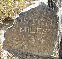
King's Highway (Charleston to Boston)
Encyclopedia
The King's Highway is a route over 1300 miles (2,092.1 km) in length in the eastern United States
. It joins Charleston
, South Carolina
, to Boston
, Massachusetts
. It was named after Charles II of England
, who in 1650 directed his colonial governors to build it. It did not become a continuous wagon road
until 1735. The part north of New York City
became the Upper Boston Post Road laid out on January 22, 1673.
An account of ye Post of ye Continent of Nth. America as they were regulated by ye Postmaster Genl. of ye Post House.
The Western Posts setts out from Philadelphia and arrives at New York Saturday night; the distance between Philadelphia & New York being 106 Miles. The Post goes Eastward every Monday morning from New York and arrives at Seabrook Thursady noon.; being 150 Miles the Post setts out from Boston at the same time; the New York Post returns with the Eastern Letters, and the Boston Post with the Western. Bags are dropt at New London, Stommington, Rhode Island, and Bristol. The Post from Boston to Pisacataway being 70 Miles leaves Letters at Ipswich, Salem, Marblehead, Newberry. There are offices keept at Burlington, Perth Amboy, New Jersey, New London and Stommington in Connecticott, at Rhode Island, Bristol, Ipswich, Salem, Marblehead, & Newberry. and the 3 great offices are Boston, New York, and Phildelphia.
 The Boston Post Road
was a system of mail-delivery routes between New York City
and Boston
, Massachusetts
that evolved into the first major highways in the United States
. The Upper Post Road was originally called the Pequot Path and had been in use by native Americans long before Europeans arrived. Some of these important native trails had been pounded by moccasin-shod
feet for so many years that they were two feet below the surrounding woodland.
The colonists first used this trail to deliver the mail using post riders
. The first ride to lay-out the Upper Post Road started on January 1, 1673. Later, the newly-blazed trail was widened and smoothed to the point where horse-drawn wagons or stagecoach
es could use the road
. During the 19th century, turnpike
companies took over and improved pieces of the road. Large sections of the various routes are still called the King's Highway and Boston Post Road. Much of the Post Road is now U.S. Route 1
, and U.S. Route 20
.

United States
The United States of America is a federal constitutional republic comprising fifty states and a federal district...
. It joins Charleston
Charleston, South Carolina
Charleston is the second largest city in the U.S. state of South Carolina. It was made the county seat of Charleston County in 1901 when Charleston County was founded. The city's original name was Charles Towne in 1670, and it moved to its present location from a location on the west bank of the...
, South Carolina
South Carolina
South Carolina is a state in the Deep South of the United States that borders Georgia to the south, North Carolina to the north, and the Atlantic Ocean to the east. Originally part of the Province of Carolina, the Province of South Carolina was one of the 13 colonies that declared independence...
, to Boston
Boston
Boston is the capital of and largest city in Massachusetts, and is one of the oldest cities in the United States. The largest city in New England, Boston is regarded as the unofficial "Capital of New England" for its economic and cultural impact on the entire New England region. The city proper had...
, Massachusetts
Massachusetts
The Commonwealth of Massachusetts is a state in the New England region of the northeastern United States of America. It is bordered by Rhode Island and Connecticut to the south, New York to the west, and Vermont and New Hampshire to the north; at its east lies the Atlantic Ocean. As of the 2010...
. It was named after Charles II of England
Charles II of England
Charles II was monarch of the three kingdoms of England, Scotland, and Ireland.Charles II's father, King Charles I, was executed at Whitehall on 30 January 1649, at the climax of the English Civil War...
, who in 1650 directed his colonial governors to build it. It did not become a continuous wagon road
Road
A road is a thoroughfare, route, or way on land between two places, which typically has been paved or otherwise improved to allow travel by some conveyance, including a horse, cart, or motor vehicle. Roads consist of one, or sometimes two, roadways each with one or more lanes and also any...
until 1735. The part north of New York City
New York City
New York is the most populous city in the United States and the center of the New York Metropolitan Area, one of the most populous metropolitan areas in the world. New York exerts a significant impact upon global commerce, finance, media, art, fashion, research, technology, education, and...
became the Upper Boston Post Road laid out on January 22, 1673.
Mail delivery in the Northeast
Herman Moll’s 1729 “Post Map” described the route as follows:An account of ye Post of ye Continent of Nth. America as they were regulated by ye Postmaster Genl. of ye Post House.
The Western Posts setts out from Philadelphia and arrives at New York Saturday night; the distance between Philadelphia & New York being 106 Miles. The Post goes Eastward every Monday morning from New York and arrives at Seabrook Thursady noon.; being 150 Miles the Post setts out from Boston at the same time; the New York Post returns with the Eastern Letters, and the Boston Post with the Western. Bags are dropt at New London, Stommington, Rhode Island, and Bristol. The Post from Boston to Pisacataway being 70 Miles leaves Letters at Ipswich, Salem, Marblehead, Newberry. There are offices keept at Burlington, Perth Amboy, New Jersey, New London and Stommington in Connecticott, at Rhode Island, Bristol, Ipswich, Salem, Marblehead, & Newberry. and the 3 great offices are Boston, New York, and Phildelphia.
Boston Post Road
Boston Post Road
The Boston Post Road was a system of mail-delivery routes between New York City and Boston, Massachusetts that evolved into the first major highways in the United States.The three major alignments were the Lower Post Road The Boston Post Road was a system of mail-delivery routes between New York...
was a system of mail-delivery routes between New York City
New York City
New York is the most populous city in the United States and the center of the New York Metropolitan Area, one of the most populous metropolitan areas in the world. New York exerts a significant impact upon global commerce, finance, media, art, fashion, research, technology, education, and...
and Boston
Boston
Boston is the capital of and largest city in Massachusetts, and is one of the oldest cities in the United States. The largest city in New England, Boston is regarded as the unofficial "Capital of New England" for its economic and cultural impact on the entire New England region. The city proper had...
, Massachusetts
Massachusetts
The Commonwealth of Massachusetts is a state in the New England region of the northeastern United States of America. It is bordered by Rhode Island and Connecticut to the south, New York to the west, and Vermont and New Hampshire to the north; at its east lies the Atlantic Ocean. As of the 2010...
that evolved into the first major highways in the United States
United States
The United States of America is a federal constitutional republic comprising fifty states and a federal district...
. The Upper Post Road was originally called the Pequot Path and had been in use by native Americans long before Europeans arrived. Some of these important native trails had been pounded by moccasin-shod
Moccasin (footwear)
A moccasin is a slipper made of deerskin or other soft leather, consisting of a sole and sides made of one piece of leather, stitched together at the top, and sometimes with a vamp . Though sometimes worn inside, it is chiefly intended for outdoor use, as in exploring wildernesses and running from...
feet for so many years that they were two feet below the surrounding woodland.
The colonists first used this trail to deliver the mail using post riders
Post riders
Post riders or postriders describes a horse and rider postal delivery system that existed at various times and various places throughout history...
. The first ride to lay-out the Upper Post Road started on January 1, 1673. Later, the newly-blazed trail was widened and smoothed to the point where horse-drawn wagons or stagecoach
Stagecoach
A stagecoach is a type of covered wagon for passengers and goods, strongly sprung and drawn by four horses, usually four-in-hand. Widely used before the introduction of railway transport, it made regular trips between stages or stations, which were places of rest provided for stagecoach travelers...
es could use the road
Road
A road is a thoroughfare, route, or way on land between two places, which typically has been paved or otherwise improved to allow travel by some conveyance, including a horse, cart, or motor vehicle. Roads consist of one, or sometimes two, roadways each with one or more lanes and also any...
. During the 19th century, turnpike
Toll road
A toll road is a privately or publicly built road for which a driver pays a toll for use. Structures for which tolls are charged include toll bridges and toll tunnels. Non-toll roads are financed using other sources of revenue, most typically fuel tax or general tax funds...
companies took over and improved pieces of the road. Large sections of the various routes are still called the King's Highway and Boston Post Road. Much of the Post Road is now U.S. Route 1
U.S. Route 1
U.S. Route 1 is a major north–south U.S. Highway that serves the East Coast of the United States. It runs 2,377 miles from Fort Kent, Maine at the Canadian border south to Key West, Florida. U.S. 1 generally parallels Interstate 95, though it is significantly farther west between...
, and U.S. Route 20
U.S. Route 20
U.S. Route 20 is an east–west United States highway. As the "0" in its route number implies, US 20 is a coast-to-coast route. Spanning , it is the longest road in the United States, and the route sparsely parallels Interstate 90...
.
Route of the King's Highway
- Boston, MA
- New Haven, CT
- Fairfield, CT
- Greenwich, CT
- Rye, NY
- Kingsbridge, NY
- New York CityNew York CityNew York is the most populous city in the United States and the center of the New York Metropolitan Area, one of the most populous metropolitan areas in the world. New York exerts a significant impact upon global commerce, finance, media, art, fashion, research, technology, education, and...
- Newark, NJ
- Elizabeth, NJ
- Rahway, NJ
- Perth Amboy, NJ
- New Brunswick, NJ
- Princeton, NJ
- Trenton, NJ
- Bordentown, NJ
- Burlington, NJ
- Philadelphia, PA
- Chester, PA
- Wilmington, DE
- New Castle, DE
- Annapolis, MD
- Alexandria, VA
- Fredericksburg, VA
- Bowling Green, VA
- King William, VA
- New Kent, VA
- Williamsburg, VA
- Yorktown, VA
- Hampton, VA
- Norfolk, VA
- Suffolk, VA
- Edenton, NC
- New Bern, NC
- Wilmington, NC
- Georgetown, SC
- Charleston, SC
See also
- List of roads and highways
- Washington-Rochambeau Revolutionary RouteWashington-Rochambeau Revolutionary RouteThe Washington–Rochambeau Revolutionary Route is a 680-mile -long series of encampments and roads used by U.S. Continental Army troops under George Washington and French troops under Jean-Baptiste de Rochambeau during their march from Newport, Rhode Island to Yorktown, Virginia in 1781. The route...
- Assunpink TrailAssunpink TrailThe Assunpink Trail was a Native American trail in what later became Middlesex, Somerset, and Mercer counties in the central and western part of New Jersey...