
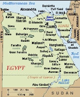
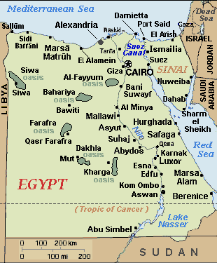
Kharga Oasis
Encyclopedia
Egypt
Egypt , officially the Arab Republic of Egypt, Arabic: , is a country mainly in North Africa, with the Sinai Peninsula forming a land bridge in Southwest Asia. Egypt is thus a transcontinental country, and a major power in Africa, the Mediterranean Basin, the Middle East and the Muslim world...
's five western oases
Oasis
In geography, an oasis or cienega is an isolated area of vegetation in a desert, typically surrounding a spring or similar water source...
. It is located in the Libyan Desert
Libyan Desert
The Libyan Desert covers an area of approximately 1,100,000 km2, it extends approximately 1100 km from east to west, and 1,000 km from north to south, in about the shape of a rectangle...
, about 200 km to the west of the Nile
Nile
The Nile is a major north-flowing river in North Africa, generally regarded as the longest river in the world. It is long. It runs through the ten countries of Sudan, South Sudan, Burundi, Rwanda, Democratic Republic of the Congo, Tanzania, Kenya, Ethiopia, Uganda and Egypt.The Nile has two major...
valley, and is some 150 km long. It is located in and is the capital of New Valley Governorate. This oasis, which was known as the 'Southern Oasis' to the Ancient Egypt
Ancient Egypt
Ancient Egypt was an ancient civilization of Northeastern Africa, concentrated along the lower reaches of the Nile River in what is now the modern country of Egypt. Egyptian civilization coalesced around 3150 BC with the political unification of Upper and Lower Egypt under the first pharaoh...
ians, is the largest of the oases in the Libyan desert of Egypt and "consists of a depression about 160km long and from 20km to 80km wide." Its population is over 100,000.
Overview
Kharga is the most modernized of Egypt's western oases. The main town is a highly functional town with all modern facilities, and virtually nothing left of old architecture. Although framed by the oasis, there is no oasis feeling to it; unlike all other oases in this part of Egypt. There are extensive thorn palm, acacia, buffalo thorn and jujube forests in the oasis surrounding the modern town of Kharga. Many remnant wildlife species inhabit this region.Darb el-Arbain caravan route
The Darb el-Arbain trade route, passing through Kharga in the south and AsyutAsyut
Asyut is the capital of the modern Asyut Governorate in Egypt; the ancient city of the same name is situated nearby. The modern city is located at , while the ancient city is at .- Etymology :...
in the north, was a long caravan route running north-south between Middle Egypt and the Sudan. It was used from as early as the Old Kingdom of Egypt for the transport and trade of gold
Gold
Gold is a chemical element with the symbol Au and an atomic number of 79. Gold is a dense, soft, shiny, malleable and ductile metal. Pure gold has a bright yellow color and luster traditionally considered attractive, which it maintains without oxidizing in air or water. Chemically, gold is a...
, ivory
Ivory
Ivory is a term for dentine, which constitutes the bulk of the teeth and tusks of animals, when used as a material for art or manufacturing. Ivory has been important since ancient times for making a range of items, from ivory carvings to false teeth, fans, dominoes, joint tubes, piano keys and...
, spice
Spice
A spice is a dried seed, fruit, root, bark, or vegetative substance used in nutritionally insignificant quantities as a food additive for flavor, color, or as a preservative that kills harmful bacteria or prevents their growth. It may be used to flavour a dish or to hide other flavours...
s, wheat
Wheat
Wheat is a cereal grain, originally from the Levant region of the Near East, but now cultivated worldwide. In 2007 world production of wheat was 607 million tons, making it the third most-produced cereal after maize and rice...
, animal
Animal
Animals are a major group of multicellular, eukaryotic organisms of the kingdom Animalia or Metazoa. Their body plan eventually becomes fixed as they develop, although some undergo a process of metamorphosis later on in their life. Most animals are motile, meaning they can move spontaneously and...
s and plant
Plant
Plants are living organisms belonging to the kingdom Plantae. Precise definitions of the kingdom vary, but as the term is used here, plants include familiar organisms such as trees, flowers, herbs, bushes, grasses, vines, ferns, mosses, and green algae. The group is also called green plants or...
s. The maximum extent of the Darb el-Arbain was northward from Kobbei
Kobbei
Kobbei is a former town in North Darfur of western Sudan, west of Al-Fashir. It is now deserted. At its peak in the 19th century it was a thriving town, the largest in Darfur, with a population of up to 8,000...
, 25 miles north of al-Fashir
Al-Fashir
Al Fashir or Al-Fashir is the capital city of North Darfur, Sudan. It is a large town in the Darfur region of northwestern Sudan, 120 miles northeast of Nyala, Sudan....
, passing through the desert, through Bir Natrum and Wadi Howar
Wadi Howar
Wadi Howar is a wadi in Sudan and Chad. It travels approximately 400 kilometres in a northeasterly direction from the Ouaddaï highlands in Chad across the North Darfur state of Sudan, before losing itself in the Libyan Desert...
, and ending in Egypt
Egypt
Egypt , officially the Arab Republic of Egypt, Arabic: , is a country mainly in North Africa, with the Sinai Peninsula forming a land bridge in Southwest Asia. Egypt is thus a transcontinental country, and a major power in Africa, the Mediterranean Basin, the Middle East and the Muslim world...
.
All the oases have always been crossroads of caravan
Camel train
A camel train is a series of camels carrying goods or passengers in a group as part of a regular or semi-regular service between two points. Although they rarely travelled faster than the walking speed of a man, camels' ability to handle harsh conditions made camel trains a vital part of...
routes converging from the barren desert. In the case of Kharga, this is made particularly evident by the presence of a chain of fortresses that the Romans built to protect the Darb el-Arbain. The forts vary for size and function, some being just small outposts, some guarding large settlements complete with cultivation. Some were installed where earlier settlements already existed, while others were probably founded anew. All of them are made of mud bricks, but some also contain small stone temples with inscribed walls.
Described by Herodotus
Herodotus
Herodotus was an ancient Greek historian who was born in Halicarnassus, Caria and lived in the 5th century BC . He has been called the "Father of History", and was the first historian known to collect his materials systematically, test their accuracy to a certain extent and arrange them in a...
as a road "traversed ... in forty days," the Darb el-Arbain became by his time an important land route facilitating trade between Nubia
Nubia
Nubia is a region along the Nile river, which is located in northern Sudan and southern Egypt.There were a number of small Nubian kingdoms throughout the Middle Ages, the last of which collapsed in 1504, when Nubia became divided between Egypt and the Sennar sultanate resulting in the Arabization...
and Egypt
Egypt
Egypt , officially the Arab Republic of Egypt, Arabic: , is a country mainly in North Africa, with the Sinai Peninsula forming a land bridge in Southwest Asia. Egypt is thus a transcontinental country, and a major power in Africa, the Mediterranean Basin, the Middle East and the Muslim world...
. For this reason, it is sometimes referred to as the Forty Days Road.
As part of a caravan proceeding to Dafur, the English explorer W.G. Browne
William George Browne
William George Browne was an English traveller.Browne was born at Great Tower Hill, London. At seventeen he was sent to Oriel College, Oxford. Having had a moderate inheritance left him by his father, on quitting the university he applied himself entirely to literary pursuits...
paused for several days at Kharga, leaving with the rest of the group 7 June 1793. At the time a Gindi was stationed at Kharga, "belonging to Ibrahim-bey-el-kebir, to whom those villages appertain; and to [this official] is entrusted the management of what relates to the caravan during the time of its stay there."
Demographics
Native Khargans belong to the related BejaBeja people
The Beja people are an ethnic group dwelling in parts of North Africa and the Horn of Africa.-Geography:The Beja are found mostly in Sudan, but also in parts of Eritrea, and Egypt...
ethnic group. They speak their own Afro-Asiatic
Afro-Asiatic languages
The Afroasiatic languages , also known as Hamito-Semitic, constitute one of the world's largest language families, with about 375 living languages...
language, though Arabic
Arabic language
Arabic is a name applied to the descendants of the Classical Arabic language of the 6th century AD, used most prominently in the Quran, the Islamic Holy Book...
is the dominant tongue.
Transportation
A regular bus service connects the oasis to the other Western oases and to the rest of Egypt. A railway line Kharga - QenaQena
Qena is a city in Upper Egypt, and the capital of the Qena Governorate. Situated on the east bank of the Nile, it was known as Kaine during the Greco-Roman period and as Cainepolis in antiquity.- Overview :...
(Nile Valley) - Port Safaga
Port Safaga
Port Safaga, also known as Bur Safaga and Safaga , is a town in Egypt, on the coast of the Red Sea, located south of Hurghada. This small port is also a tourist area that consists of several bungalows and rest houses, including the Safaga Hotel, with a capacity of 48 rooms .Having numerous...
(Red Sea) has been in service since 1996.
Archaeological sites
The Temple of Hibis is a Saite-era temple founded by Psamtik II, which was erected largely ca. 500 BC. It is located about 2 kilometres north of modern Kharga, in a palm-grove. There is a second 1st millennium BC temple in the southern most part of the oasis at Dush. An ancient Christian cemetery at Al-Bagawat also functioned at Kharga Oasis from the 3rd to the 7th century AD. It is one of the earliest and best preserved Christian cemeteries in the ancient world.Sites
-
- (with wikimedia image sub-categories under "Category:Kharga Oasis" of external link below)
- Ain el-Beleida (Roman)
- Ain el-Labakha (Roman)
- Ain Manawir (Persian, Roman)
- Ain Shams el-Din (Coptic church)
- Ain el-Tarakwa (Roman)
- Ain Tauleib (Roman)
- Deir Mustafa Kashef (Coptic monastery)
- Deir el-Munira (Roman)
- Gabbanat el-Bagawat - CopticCopticCoptic may refer to:*The Copts: were a major ethnic group in Egypt. This term described all the people living in Egypt under Roman rule during the 4th to 6th centuries A.D., and until the Muslims took over....
cemetery - Gebel el-Teir (Rock inscriptions starting from prehistoric times)
- El-Nadura (Roman)
- Qasr el-Dabashiya (Roman)
- Qasr Dush (Greco-Roman)
- Qasr el-Ghweita (Late Period)
- Qasr el-Gibb (Roman)
- Qasr el-Zayyan (Greco-Roman)
- Sumeira (Roman)
- Temple of Hibis (Persian - c. 500s BCE.)
- Umm el-Dabadib (Roman)
- Umm Mawagir (Middle Kingdom, 2nd Intermediate Period)
- (with wikimedia image sub-categories under "Category:Kharga Oasis" of external link below)
External links
- Wilford, John Noble (6 September 2010) "Desert Roads Lead to Discovery in Egypt" The New York Times
- Information on the forts and archaelogical work
- Travel guide Khārga on Wikivoyage