
Kepler Track
Encyclopedia
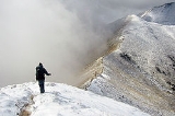
The Kepler Track is a 60 km (37.3 mi) circular tramping track which travels through some of the spectacular scenery on the South Island
of New Zealand
. The track passes through many landscapes of the Fiordland National Park
ranging from rocky mountain ridges to tall mossy forests, from lake shores to deep gorges. Like the mountains it traverses, the track is named after Johannes Kepler
. The track is administered by New Zealand Department of Conservation
(DOC).
Compared with other tracks in New Zealand, this walking track is constructed to a very high standard. Most streams are bridged, boardwalks cover boggy areas and the very steep sections have steps. It is a moderate walking track that takes three to four days to complete.
The Kepler Track is also home to the Kepler Challenge, an annual running race that traverses the whole 60 kilometres in less than five hours.
Richard Henry, Fiordland's first ranger, lived at the southern end of Lake Te Anau for many years and often explored the Kepler area. James McKerrow named the range after the 17th Century German astronomer Johannes Kepler.
Early tracks up onto Mt. Luxmore were cut by Jack Beer to provide summer grazing for his sheep.
Many tracks in New Zealand have evolved from Māori trails or pioneer exploration routes. The Kepler track however was established in 1988 and opened in February of that year as a Great Walk as part of the Fiordland National Park Centennial celebrations. Funding came from New Zealand Tourist and Publicity Department. It was designed to ease the strain on the popular Milford
and Routeburn Track
s.
The track had a considerable contribution from the International Expedition Operation Raleigh during 1986/87, when expeditioners from around the world constructed much of the walkways and the Iris Burn and Mount Luxmore huts.
The caves at Mt Luxmore were also mapped and Mount Raleigh was named above the Iris Burn.
Control Gates. It can be walked in either direction. If time is short, the track can be shortened to three days by exiting or entering at the Rainbow Reach swing bridge using a car or bus. Trampers are encouraged to complete a 'Notice of Intentions' form at the Fiordland Visitors Information centre, prior to any walk.
While it is possible to complete the Kepler whilst camping this requires a 10 hour hike between Brod Bay and Iris Burn campsites. A much easier option is to stay at Luxmore Hut on the first night, then continue on to Iris Burn campsite for the second night, completing the track to Rainbow Reach on day three.
Peak season prices for accommodation are $51.10 for the huts and $15.30 for the campsites (26 October to 26 April). Off peak accommodation costs $15.30 NZD for the huts and $5.10 NZD for the campsites.
The Lake Te Anau Control Gates are approximately 4.6 kilometres (2.9 mi) from the DOC visitors centre in Te Anau
.
The DOC provides very conservative estimates on the hiking time from point to point on the track, and experienced hikers may cover quoted distances in half of the recommended time.
.jpg)
(4.6 km or 2.9 mi away) and Manapouri
have a full range of accommodation and shops catering to all tramping needs.
The Kepler Track is accessed from the Lake Te Anau Control Gates, either by road or a 50-minute walk from the Fiordland National Park
Visitor Centre in Te Anau, or over the swingbridge across the Waiau River
at Rainbow Reach, a ten minute (12 km or 7.5 mi) drive from Te Anau.
Shuttle buses also operate during the summer months to entry and exit points on the track and a scheduled boat service provides access to Brod Bay.
South Island
The South Island is the larger of the two major islands of New Zealand, the other being the more populous North Island. It is bordered to the north by Cook Strait, to the west by the Tasman Sea, to the south and east by the Pacific Ocean...
of New Zealand
New Zealand
New Zealand is an island country in the south-western Pacific Ocean comprising two main landmasses and numerous smaller islands. The country is situated some east of Australia across the Tasman Sea, and roughly south of the Pacific island nations of New Caledonia, Fiji, and Tonga...
. The track passes through many landscapes of the Fiordland National Park
Fiordland National Park
Fiordland National Park occupies the southwest corner of the South Island of New Zealand. It is the largest of the 14 national parks in New Zealand, with an area of 12,500 km², and a major part of the Te Wahipounamu World Heritage site...
ranging from rocky mountain ridges to tall mossy forests, from lake shores to deep gorges. Like the mountains it traverses, the track is named after Johannes Kepler
Johannes Kepler
Johannes Kepler was a German mathematician, astronomer and astrologer. A key figure in the 17th century scientific revolution, he is best known for his eponymous laws of planetary motion, codified by later astronomers, based on his works Astronomia nova, Harmonices Mundi, and Epitome of Copernican...
. The track is administered by New Zealand Department of Conservation
New Zealand Department of Conservation
The Department of Conservation , commonly known by its acronym, "DOC", is the state sector organisation which deals with the conservation of New Zealand’s natural and historic heritage...
(DOC).
Compared with other tracks in New Zealand, this walking track is constructed to a very high standard. Most streams are bridged, boardwalks cover boggy areas and the very steep sections have steps. It is a moderate walking track that takes three to four days to complete.
The Kepler Track is also home to the Kepler Challenge, an annual running race that traverses the whole 60 kilometres in less than five hours.
History
Māori legend has it that Rakaihautu, legendary leader of the Māori canoe Uruao, is said to have named the great lakes while exploring the interior of the South Island. During a period of wet weather his party found a large and beautiful lake which they named Te Aria Au, meaning cave of rain, and just south of it another lake which Rakaihautu named Roto Ua, the lake where rain is constant. Today we know Roto Ua as Lake Manapouri. The Kepler is situated between the two lakes.Richard Henry, Fiordland's first ranger, lived at the southern end of Lake Te Anau for many years and often explored the Kepler area. James McKerrow named the range after the 17th Century German astronomer Johannes Kepler.
Early tracks up onto Mt. Luxmore were cut by Jack Beer to provide summer grazing for his sheep.
Many tracks in New Zealand have evolved from Māori trails or pioneer exploration routes. The Kepler track however was established in 1988 and opened in February of that year as a Great Walk as part of the Fiordland National Park Centennial celebrations. Funding came from New Zealand Tourist and Publicity Department. It was designed to ease the strain on the popular Milford
Milford Track
The Milford Track is a widely known tramping route in New Zealand – located amidst mountains and temperate rain forest in Fiordland National Park in the southwest of the South Island....
and Routeburn Track
Routeburn Track
The Routeburn Track is a world-renowned tramping track found in the South Island of New Zealand. The track is usually completed by starting on the Queenstown side of the Southern Alps, at the northern end of Lake Wakatipu, and finishing on the Te Anau side, at the Divide, several kilometres from...
s.
The track had a considerable contribution from the International Expedition Operation Raleigh during 1986/87, when expeditioners from around the world constructed much of the walkways and the Iris Burn and Mount Luxmore huts.
The caves at Mt Luxmore were also mapped and Mount Raleigh was named above the Iris Burn.
Tramping
The track is usually recommended to be walked in this route from the Lake Te AnauLake Te Anau
Lake Te Anau is in the southwestern corner of the South Island of New Zealand. Its name was originally Te Ana-au, Maori for 'The cave of swirling water'. The lake covers an area of 344 km², making it the second-largest lake by surface area in New Zealand and the largest in the South Island...
Control Gates. It can be walked in either direction. If time is short, the track can be shortened to three days by exiting or entering at the Rainbow Reach swing bridge using a car or bus. Trampers are encouraged to complete a 'Notice of Intentions' form at the Fiordland Visitors Information centre, prior to any walk.
While it is possible to complete the Kepler whilst camping this requires a 10 hour hike between Brod Bay and Iris Burn campsites. A much easier option is to stay at Luxmore Hut on the first night, then continue on to Iris Burn campsite for the second night, completing the track to Rainbow Reach on day three.
Peak season prices for accommodation are $51.10 for the huts and $15.30 for the campsites (26 October to 26 April). Off peak accommodation costs $15.30 NZD for the huts and $5.10 NZD for the campsites.
| Place | Day (Full) | Day (Short) | Distance | Time | Description |
|---|---|---|---|---|---|
| Lake Te Anau Control Gates 45°26′30.5"S 167°41′23"E |
1 | 5.6 km (3.5 mi) | 1.5 hours | The track follows the shores of Lake Te Anau in beech forest to sandy Brod Bay where camping is permitted, and where it is possible to enter or exit the track by an arranged shuttle boat. | |
| Brod Bay | |||||
| 1 | 8.2 km (5.1 mi) | 3.5 - 4.5 hours | From Brod Bay, the track climbs up past limestone bluffs (at 747 m or 2,450.8 ft) to Luxmore Hut (1085 m or 3,559.7 ft) on Mt Luxmore. A short walk from the hut leads to a cave, one of about 30 in the area, of which many are still unexplored. | ||
| Luxmore Hut | |||||
| 2 | 2 | 14.6 km (9.1 mi) | 5 – 6 hours | A gradual climb from the hut to Luxmore Saddle (1400 m or 4,593.2 ft) which is the highest point on the main trail, offering extensive views of the park. There is an opportunity to climb to the peak of Mount Luxmore (1472 m or 4,829.4 ft) for a 360 degree view including Lake Te Anau. Emergency shelters are located at Forrest Burn and Hanging Valley - though overnight stays are expressly forbidden, except in an emergency. The path then follows a long, open ridge toward the Iris Burn and descends via a series of zigzags into a hanging valley. The track descends through forest, and provides a view of a large natural landslide. The Iris Burn Hut (497 m or 1,630.6 ft) is sited in a large tussock clearing 1.5 km (0.93205910497471 mi) from Iris Burn waterfall. |
|
| Iris Burn Hut | |||||
| 3 | 3 | 16.2 km (10.1 mi) | 5 – 6 hours | The track climbs over a low saddle and wanders through mixed forest to the large slip formed during heavy rain in January 1984. The track sidles through a gorge to come out on river flats near the mouth of the Iris Burn. It follows the lakeshore around Shallow Bay to Moturau Hut, situated beside a beautiful beach with panoramic views of Lake Manapouri. | |
| Moturau Hut 45°28′54"S 167°36′37"E |
|||||
| 4 | 6 km (3.7 mi) | 1.5 – 2 hours | This short section crosses many small streams, before running next to the Waiau River until it reaches the Rainbow Reach swing bridge, where there is a carpark, and tramper bus services. | ||
| Rainbow Reach Swing Bridge 45°29′27"S 167°39′45"E |
|||||
| 9.5 km (5.9 mi) | 2.5 - 3.5 hours | The undulating track here traverses mixed forest and crosses many small streams, arriving back at the Control Gates. | |||
| Lake Te Anau Control Gates |
The Lake Te Anau Control Gates are approximately 4.6 kilometres (2.9 mi) from the DOC visitors centre in Te Anau
Te Anau
Te Anau is a town in the South Island of New Zealand. It is on the eastern shore of Lake Te Anau in Fiordland. Lake Te Anau is the largest lake in the South Island and second only within New Zealand to Lake Taupo. The 2001 census recorded the town's population as 1,857...
.
The DOC provides very conservative estimates on the hiking time from point to point on the track, and experienced hikers may cover quoted distances in half of the recommended time.
Location
The Kepler Track is located in the south west of the South Island. The nearest townships of Te AnauTe Anau
Te Anau is a town in the South Island of New Zealand. It is on the eastern shore of Lake Te Anau in Fiordland. Lake Te Anau is the largest lake in the South Island and second only within New Zealand to Lake Taupo. The 2001 census recorded the town's population as 1,857...
(4.6 km or 2.9 mi away) and Manapouri
Manapouri
Manapouri is a small town in Southland / Fiordland, in the southwest corner of the South Island, in New Zealand. Located at the edge of the Fiordland National Park, on the eastern shore of Lake Manapouri, close to its outflow into the Waiau River, tourist boat services are based in the...
have a full range of accommodation and shops catering to all tramping needs.
The Kepler Track is accessed from the Lake Te Anau Control Gates, either by road or a 50-minute walk from the Fiordland National Park
Fiordland National Park
Fiordland National Park occupies the southwest corner of the South Island of New Zealand. It is the largest of the 14 national parks in New Zealand, with an area of 12,500 km², and a major part of the Te Wahipounamu World Heritage site...
Visitor Centre in Te Anau, or over the swingbridge across the Waiau River
Waiau River, Southland
Waiau River is the largest river in the Southland Region of New Zealand. It is the outflow of Lake Te Anau, flowing from it into Lake Manapouri 10 kilometres to the south, and from there flows south for 70 kilometres before reaching the Foveaux Strait eight kilometres south of Tuatapere...
at Rainbow Reach, a ten minute (12 km or 7.5 mi) drive from Te Anau.
Shuttle buses also operate during the summer months to entry and exit points on the track and a scheduled boat service provides access to Brod Bay.