

Kentucky Route 880
Encyclopedia
Kentucky Route 880 is a 3-mile-long east–west state highway
that forms a connector between U.S. Route 231
and KY 234
in the city of Bowling Green
, Kentucky
. The western terminus of the route is at U.S.231 in Bowling Green. The eastern terminus is at Kentucky Route 234
near the community of Indian Hills east of downtown.
 The old route started at the junction of KY 185 (Sixth Avenue) and Gordon Avenue near downtown Bowling Green. KY 185 turned north onto Gordon Avenue while Sixth Avenue became Veterans Memorial Boulevard and KY 880. From its starting point, KY 880 ran approximately 3.6 miles (5.8 km) around northwestern Bowling Green, intersecting Kentucky Route 2665
(Glen Lily Road) ahead of a junction with U.S. Route 231
. US 231 turned south onto the loop, joining KY 880, while U.S. Route 231 Business, the former routing of US 231 into downtown Bowling Green, continued east.
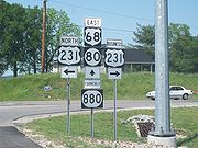
The conjoined routes, collectively named Campbell Lane, ran for five miles (8 km) around the southern portion of Bowling Green, passing through one of the main commercial districts of the city. 1.5 miles (2.4 km) into the concurrency, US 231 and KY 880 intersect the conjoined U.S. Route 68
/Kentucky Route 80. Two intersections to the east, Campbell Lane meets U.S. Route 31W
. The routes remained overlapped to another intersection with US 231 Business, where US 231 separated from the loop and followed its previous alignment south out of the city. The old route also contained the current route from this point eastward.
exit 26.
KY 880 is currently partially two lanes before bridging out into four lanes near its Eastern Terminus.Lovers Lane is currently undergoing widening to accommodate increased residential and commercial buildup along the remaining two lane section.
On 9 August 1999, US 231 was rerouted onto KY 880 between its two junctions with KY 880 west and south of the city, forming a concurrency between the two routes. The former alignment of US 231 through Bowling Green was re-designated as US 231 Business.
In March 2008, a good deal of the former length of KY 880 was redesignated as new routing for, from west to east, US 68
, KY 80, and US 231. The portion of the highway that was formerly conjoined with US 231 is now designated solely as that highway.
State highway
State highway, state road or state route can refer to one of three related concepts, two of them related to a state or provincial government in a country that is divided into states or provinces :#A...
that forms a connector between U.S. Route 231
U.S. Route 231
U.S. Route 231 is a parallel route of U.S. Route 31. It currently runs for 912 miles from St. John, Indiana, at U.S. Route 41 to south of U.S. Route 98 in Downtown Panama City, Florida.One of its most notable landmarks is the William H...
and KY 234
Kentucky Route 234
Kentucky Route 234 is a 20.033 mile long north–south state highway in southern Kentucky. The southern terminus of the route is at Kentucky Route 101 six miles north of Scottsville. The northern terminus is at U.S...
in the city of Bowling Green
Bowling Green, Kentucky
Bowling Green is the third-most populous city in the state of Kentucky after Louisville and Lexington, with a population of 58,067 as of the 2010 Census. It is the county seat of Warren County and the principal city of the Bowling Green, Kentucky Metropolitan Statistical Area with an estimated 2009...
, Kentucky
Kentucky
The Commonwealth of Kentucky is a state located in the East Central United States of America. As classified by the United States Census Bureau, Kentucky is a Southern state, more specifically in the East South Central region. Kentucky is one of four U.S. states constituted as a commonwealth...
. The western terminus of the route is at U.S.231 in Bowling Green. The eastern terminus is at Kentucky Route 234
Kentucky Route 234
Kentucky Route 234 is a 20.033 mile long north–south state highway in southern Kentucky. The southern terminus of the route is at Kentucky Route 101 six miles north of Scottsville. The northern terminus is at U.S...
near the community of Indian Hills east of downtown.
Previous routing
Kentucky Route 2665
Kentucky Route 2665 is an east–west highway in Warren County, Kentucky. Starting in the western part of the city of Bowling Green, it winds into the countryside before ending in western Warren County...
(Glen Lily Road) ahead of a junction with U.S. Route 231
U.S. Route 231
U.S. Route 231 is a parallel route of U.S. Route 31. It currently runs for 912 miles from St. John, Indiana, at U.S. Route 41 to south of U.S. Route 98 in Downtown Panama City, Florida.One of its most notable landmarks is the William H...
. US 231 turned south onto the loop, joining KY 880, while U.S. Route 231 Business, the former routing of US 231 into downtown Bowling Green, continued east.
The conjoined routes, collectively named Campbell Lane, ran for five miles (8 km) around the southern portion of Bowling Green, passing through one of the main commercial districts of the city. 1.5 miles (2.4 km) into the concurrency, US 231 and KY 880 intersect the conjoined U.S. Route 68
U.S. Route 68
U.S. Route 68 is an east–west United States highway that runs for from northwest Ohio to western Kentucky. The highway's western terminus is at U.S. Route 62 in Reidland, Kentucky. Its eastern terminus is at Interstate 75 in Findlay, Ohio...
/Kentucky Route 80. Two intersections to the east, Campbell Lane meets U.S. Route 31W
U.S. Route 31W
U.S. Route 31W is the westernmost of two parallel routes for U.S. Route 31 from Nashville, Tennessee to Louisville, Kentucky. At one time, it split with U.S...
. The routes remained overlapped to another intersection with US 231 Business, where US 231 separated from the loop and followed its previous alignment south out of the city. The old route also contained the current route from this point eastward.
Current routing
Starting at a junction with US 231 and US 231 business, KY 880 runs to the northeast for approximately three miles as Lovers Lane until reaching its eastern terminus at KY 234, less than a mile from Interstate 65Interstate 65
Interstate 65 is a major Interstate Highway in the United States. The southern terminus is located at an intersection with Interstate 10 in Mobile, Alabama, and its northern terminus is at an interchange with Interstate 90 , U.S. Route 12, and U.S...
exit 26.
KY 880 is currently partially two lanes before bridging out into four lanes near its Eastern Terminus.Lovers Lane is currently undergoing widening to accommodate increased residential and commercial buildup along the remaining two lane section.
History
KY 880 was added to the State Secondary and Rural Secondary systems on 9 February 1983. On 6 April 1990, the Northwest Bypass, a 4.389 miles (7.1 km) segment of KY 880 between KY 185 and Tomblinson Way, was added to the State Secondary System. An additional 0.638 miles (1 km) were added to KY 880 on 18 May 1992.On 9 August 1999, US 231 was rerouted onto KY 880 between its two junctions with KY 880 west and south of the city, forming a concurrency between the two routes. The former alignment of US 231 through Bowling Green was re-designated as US 231 Business.
In March 2008, a good deal of the former length of KY 880 was redesignated as new routing for, from west to east, US 68
U.S. Route 68
U.S. Route 68 is an east–west United States highway that runs for from northwest Ohio to western Kentucky. The highway's western terminus is at U.S. Route 62 in Reidland, Kentucky. Its eastern terminus is at Interstate 75 in Findlay, Ohio...
, KY 80, and US 231. The portion of the highway that was formerly conjoined with US 231 is now designated solely as that highway.