
Kellington
Encyclopedia
Kellington is a small village and civil parish
in the Selby
district of North Yorkshire
, England
, on the banks of the River Aire
. Situated almost equidistant between the towns of Pontefract
and Selby
, the village dates back to at least the 11th Century when it was listed in the Domesday Book
(as Chelinctone). The semi-rural community grew in size with the advent of local mining as housing was built to accommodate the workers of nearby Kellingley Colliery
.
Due to its location at the southernmost tip of North Yorkshire, the village is close to the borders of West, East and South Yorkshire. Its proximity to both the A19
and M62
major roads has resulted in a steady population growth, although to a lesser extent than its neighbour, Eggborough
.
The low lying ground that separates the village from the River Aire
has given rise to a history of flooding the surrounding farmland, most recently in 2000 when residents were woken in the middle of the night by police who advised them to evacuate as a precationary measure. As it was only two people took the police's advice and, along with their dogs, spent the rest of the night at Sherburn High School. The floodbanks easily contained the threat to the village itself.
The Selby District Councillors for the village are local husband and wife team, John and Mary McCartney. John is also the North Yorkshire County Councillor for the division of Osgoldcross, which includes Kellington.
In 2008 the continuation of Kellington as a separate village was put at risk because of a proposal to turn it, along with neighbouring Beal and Eggborough, into a new town, under a scheme being promoted by the then Labour government of building so-called eco-towns around the country. This specific proposal was put in by a Leeds based developer, GMI. Led by John and Mary McCartney all three villages rose up in anger. Using imaginative media stunts, innovative campaigning, sending thousands of emails and letters to decision makers and local and regional newspapers, lobbying those those decision makers and attracting TV coverage the villagers were within a year successful. And, GMI, after spending many thousands of pounds scuttled back to their hideout in Leeds.
 Sitting in the shadow of nearby Eggborough Power Station
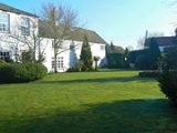
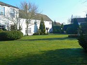
, Kellington has a variety of housing, with traditional country cottages, council housing and modern housing estates. The village is served by a pub, hotel & restaurant, Kellington Manor Hotel, http://kellingtonmanor.com which was previously known as Tree Tops and also as Squires, a small public house, The Red Lion, as well as a small convenience store and a Post Office. There are also two guesthouses in the village and a retirement home. The majority of local children attend Kellington County Primary School, which as of February 2006 was serving 133 pupils.
Located just inside the village boundary is Beal Carrs, a watered area formed in 1999 as a result of extensive flooding. Popular with birdwatchers, the Carrs are visited by Kestrels, Grey Herons and other birds and wildfowl.
Kellington
was named after the village.
The vessel was recently vandelised while docked in Middlesbrough.
Civil parish
In England, a civil parish is a territorial designation and, where they are found, the lowest tier of local government below districts and counties...
in the Selby
Selby (district)
Selby is a local government district of North Yorkshire, England. The local authority, Selby District Council, is based in the town of Selby and provides services to an area which includes Tadcaster and a host of villages....
district of North Yorkshire
North Yorkshire
North Yorkshire is a non-metropolitan or shire county located in the Yorkshire and the Humber region of England, and a ceremonial county primarily in that region but partly in North East England. Created in 1974 by the Local Government Act 1972 it covers an area of , making it the largest...
, England
England
England is a country that is part of the United Kingdom. It shares land borders with Scotland to the north and Wales to the west; the Irish Sea is to the north west, the Celtic Sea to the south west, with the North Sea to the east and the English Channel to the south separating it from continental...
, on the banks of the River Aire
River Aire
The River Aire is a major river in Yorkshire, England of length . Part of the river is canalised, and is known as the Aire and Calder Navigation....
. Situated almost equidistant between the towns of Pontefract
Pontefract
Pontefract is an historic market town in West Yorkshire, England. Traditionally in the West Riding, near the A1 , the M62 motorway and Castleford. It is one of the five towns in the metropolitan borough of the City of Wakefield and has a population of 28,250...
and Selby
Selby
Selby is a town and civil parish in North Yorkshire, England. Situated south of the city of York, along the course of the River Ouse, Selby is the largest and, with a population of 13,012, most populous settlement of the wider Selby local government district.Historically a part of the West Riding...
, the village dates back to at least the 11th Century when it was listed in the Domesday Book
Domesday Book
Domesday Book , now held at The National Archives, Kew, Richmond upon Thames in South West London, is the record of the great survey of much of England and parts of Wales completed in 1086...
(as Chelinctone). The semi-rural community grew in size with the advent of local mining as housing was built to accommodate the workers of nearby Kellingley Colliery
Kellingley Colliery
Kellingley Colliery is one of the newest of the few deep coal mines left in Britain today. It is situated at Beal in North Yorkshire, about east of Knottingley in West Yorkshire, on the A645, although the postal address is Knottingley, West Yorkshire, and east of Ferrybridge power station. The...
.
Due to its location at the southernmost tip of North Yorkshire, the village is close to the borders of West, East and South Yorkshire. Its proximity to both the A19
A19 road
The A19 is a major road in England running approximately parallel to and east of the A1 road, although the two roads meet at the northern end of the A19, the two roads originally met at the southern end of the A19 in Doncaster but the old route of the A1 was changed to the A638. From Sunderland...
and M62
M62 motorway
The M62 motorway is a west–east trans-Pennine motorway in Northern England, connecting the cities of Liverpool and Hull via Manchester and Leeds. The road also forms part of the unsigned Euroroutes E20 and E22...
major roads has resulted in a steady population growth, although to a lesser extent than its neighbour, Eggborough
Eggborough
Eggborough is a village and civil parish of 750 homes, in the Selby district of North Yorkshire, England, close to the county borders with South Yorkshire, West Yorkshire and the East Riding. The village is situated at the intersection of the A19 and the A645, approximately seven miles east of...
.
The low lying ground that separates the village from the River Aire
River Aire
The River Aire is a major river in Yorkshire, England of length . Part of the river is canalised, and is known as the Aire and Calder Navigation....
has given rise to a history of flooding the surrounding farmland, most recently in 2000 when residents were woken in the middle of the night by police who advised them to evacuate as a precationary measure. As it was only two people took the police's advice and, along with their dogs, spent the rest of the night at Sherburn High School. The floodbanks easily contained the threat to the village itself.
The Selby District Councillors for the village are local husband and wife team, John and Mary McCartney. John is also the North Yorkshire County Councillor for the division of Osgoldcross, which includes Kellington.
In 2008 the continuation of Kellington as a separate village was put at risk because of a proposal to turn it, along with neighbouring Beal and Eggborough, into a new town, under a scheme being promoted by the then Labour government of building so-called eco-towns around the country. This specific proposal was put in by a Leeds based developer, GMI. Led by John and Mary McCartney all three villages rose up in anger. Using imaginative media stunts, innovative campaigning, sending thousands of emails and letters to decision makers and local and regional newspapers, lobbying those those decision makers and attracting TV coverage the villagers were within a year successful. And, GMI, after spending many thousands of pounds scuttled back to their hideout in Leeds.
Amenities
Eggborough Power Station
Eggborough Power Station is a large coal-fired power station in North Yorkshire, England, capable of co-firing biomass. It is siuated on the River Aire, between the towns of Knottingley and Snaith, deriving its name from the nearby village of Eggborough...
, Kellington has a variety of housing, with traditional country cottages, council housing and modern housing estates. The village is served by a pub, hotel & restaurant, Kellington Manor Hotel, http://kellingtonmanor.com which was previously known as Tree Tops and also as Squires, a small public house, The Red Lion, as well as a small convenience store and a Post Office. There are also two guesthouses in the village and a retirement home. The majority of local children attend Kellington County Primary School, which as of February 2006 was serving 133 pupils.
Points of interest
Of interest in Kellington is the local parish church, St Edmunds, dating back to at least 1185, its gate posts were built in 1698 and are under a protection order.Located just inside the village boundary is Beal Carrs, a watered area formed in 1999 as a result of extensive flooding. Popular with birdwatchers, the Carrs are visited by Kestrels, Grey Herons and other birds and wildfowl.
HMS Kellington
A Ton class minesweeperTon class minesweeper
The Ton class were coastal minesweepers built in the 1950s for the Royal Navy, but also used by other navies such as the South African Navy and the Royal Australian Navy...
Kellington
HMS Kellington (M1154)
HMS Kellington was a Ton-class minesweeper of the Royal Navy, launched on 12 October 1954 and named after the village of Kellington in North Yorkshire....
was named after the village.
The vessel was recently vandelised while docked in Middlesbrough.